Related Research Articles

The zebra mussel is a small freshwater mussel. The species originates from the lakes of southern Russia and Ukraine, but has been accidentally introduced to numerous other areas and has become an invasive species in many countries worldwide. Since the 1980s, the species has invaded the Great Lakes, Hudson River, Lake Travis, Finger Lakes, Lake Bonaparte, and Lake Simcoe. The adverse effects of dreissenid mussels on freshwater systems have led to their ranking as one of the world's most invasive aquatic species.

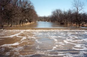
The Kankakee River is a tributary of the Illinois River, approximately 133 miles (214 km) long, in the Central Corn Belt Plains of northwestern Indiana and northeastern Illinois in the United States. At one time, the river drained one of the largest wetlands in North America and furnished a significant portage between the Great Lakes and the Mississippi River. Significantly altered from its original channel, it flows through a primarily rural farming region of reclaimed cropland, south of Lake Michigan.

The Paria River is a tributary of the Colorado River, approximately 95 miles (153 km) long, in southern Utah and northern Arizona in the United States. It drains a rugged and arid region northwest of the Colorado, flowing through roadless slot canyons along part of its course.
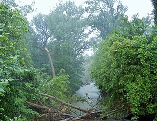
The Eel River is a 94-mile-long (151 km) tributary of the Wabash River in northern Indiana in the United States. Via the Wabash and Ohio rivers, its waters flow to the Mississippi River and ultimately the Gulf of Mexico. The Eel River rises southeast of Huntertown in Allen County and flows southwest through Allen, Whitley, Kosciusko, Wabash, Miami, and Cass counties to join the Wabash at Logansport. The river was called Kineepikwameekwa Siipiiwi - "river of the snake fish" by the Miami people, who inhabited the area at the time of European contact, the English rendered it as Ke-na-po-co-mo-co. It is the northern of the two rivers named Eel River within Indiana.
The Kansas Geological Survey (KGS) is a research and service division of the University of Kansas, charged by statute with studying and providing information on the geologic resources of Kansas. The KGS has no regulatory authority and does not take positions on natural resource issues.

Spring Mill State Park is a 1,358-acre (5 km2) state park in the state of Indiana. The park is located to the south of Bloomington, about 3 miles (5 km) east of the city of Mitchell on Indiana Highway 60. It contains a settler's village, the Gus Grissom Memorial, a nature center, and campgrounds.
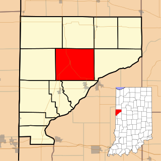
Liberty Township is one of twelve townships in Warren County, Indiana, United States. According to the 2020 census, its population was 861 and it contained 370 housing units.
The Jackson School of Geosciences at The University of Texas at Austin unites the Department of Earth and Planetary Sciences with two research units, the Institute for Geophysics and the Bureau of Economic Geology.
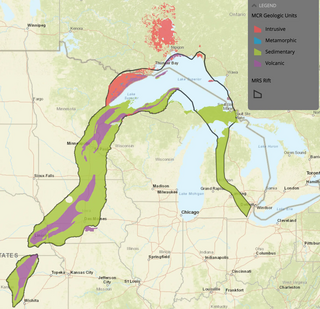
The Midcontinent Rift System (MRS) or Keweenawan Rift is a 2,000 km (1,200 mi) long geological rift in the center of the North American continent and south-central part of the North American plate. It formed when the continent's core, the North American craton, began to split apart during the Mesoproterozoic era of the Precambrian, about 1.1 billion years ago. The rift failed, leaving behind thick layers of igneous rock that are exposed in its northern reaches, but buried beneath later sedimentary formations along most of its western and eastern arms. Those arms meet at Lake Superior, which is contained within the rift valley. The lake's north shore in Ontario and Minnesota defines the northern arc of the rift. From the lake, the rift's eastern arm trends south to central lower Michigan, and possibly into Indiana, Ohio, Kentucky, Tennessee, and Alabama. The western arm runs from Lake Superior southwest through portions of Wisconsin, Minnesota, Iowa, and Nebraska to northeastern Kansas, and possibly into Oklahoma.

Howard Township is one of thirteen townships in Parke County, Indiana, United States. As of the 2020 census, its population was 382 and it contained 162 housing units. The township includes the western end of Shades State Park and the southeast quarter of Turkey Run State Park.

Albion Township is one of thirteen townships in Noble County, Indiana, United States. As of the 2020 census, its population was 2,326 and it contained 1,012 housing units.

Allen Township is one of thirteen townships in Noble County, Indiana, United States. As of the 2020 census, its population was 7,029 and it contained 3,000 housing units.

The United States Geological Survey (USGS), founded as the Geological Survey, is an agency of the United States government whose work spans the disciplines of biology, geography, geology, and hydrology. The agency was founded on March 3, 1879, to study the landscape of the United States, its natural resources, and the natural hazards that threaten it. The agency also makes maps of extraterrestrial planets and moons based on data from U.S. space probes.

Calero Reservoir, also called Calero Lake, is a reservoir in San Jose, California, located in the Calero neighborhood of Almaden Valley in South San Jose. It is the site of Calero County Park, which also includes a large area covering the lake and hundreds of acres of hills around it.
The East Arm Little Calumet River, also known as the Little Calumet River East Branch, is a 22.1-mile-long (35.6 km) portion of the Little Calumet River that begins just east of Holmesville, Indiana in New Durham Township in LaPorte County and flows west to Porter County and the Port of Indiana-Burns Waterway.
The Prairie Research Institute is a multidisciplinary research institute charged with providing objective research, expertise, and data on the natural and cultural resources of Illinois. It was established as a unit of the University of Illinois at Urbana-Champaign by a Public Act of the Illinois State Legislature in 2008. The institute comprises four state scientific surveys: the Illinois Natural History Survey (INHS), the Illinois State Archaeological Survey (ISAS), the Illinois State Geological Survey (ISGS), and the Illinois State Water Survey (ISWS), and the institute also houses the Illinois Sustainable Technology Center (ISTC). The institute has a combined total staff of more than 700 employees, with facilities located on the Urbana-Champaign campus of the University of Illinois, and field offices and research stations throughout the state.

Paleontology in Indiana refers to paleontological research occurring within or conducted by people from the U.S. state of Indiana. Indiana's fossil record stretches back to the Precambrian, when the state was inhabited by microbes. More complex organisms came to inhabit the state during the early Paleozoic era. At that time the state was covered by a warm shallow sea that would come to be inhabited by creatures like brachiopods, bryozoans, cephalopods, crinoids, and trilobites. During the Silurian period the state was home to significant reef systems. Indiana became a more terrestrial environment during the Carboniferous, as an expansive river system formed richly vegetated deltas where amphibians lived. There is a gap in the local rock record from the Permian through the Mesozoic. Likewise, little is known about the early to middle Cenozoic era. During the Ice Age however, the state was subject to glacial activity, and home to creatures like short-faced bears, camels, mammoths, and mastodons. After humans came to inhabit the state, Native Americans interpreted the fossil proboscidean remains preserved near Devil's Lake as the bones of water monsters. After the advent of formal scientific investigation one paleontological survey determined that the state was home to nearly 150 different kinds of prehistoric plants.
The Louisiana Geological Survey is a state geological survey established by the Louisiana legislature by Act 131 in 1934 to serve the citizens Louisiana by collecting, preserving, and disseminating impartial information on the geomorphology, hydrogeology, geology, paleontology, economic geology, and geological resources of Louisiana. The Louisiana Geological Survey was originally part of the Louisiana Department of Conservation. Later it was a division of the Louisiana Department of Natural Resources and finally transferred by the Louisiana legislature's HB 2353 to Louisiana State University. At Louisiana State University, it is part of the Office of Research and Economic Development.

Lake Kankakee formed 14,000 years before present (YBP) in the valley of the Kankakee River. It developed from the outwash of the Michigan Lobe, Saginaw Lobe, and the Huron-Erie Lobe of the Wisconsin glaciation. These three ice sheets formed a basin across Northwestern Indiana. It was a time when the glaciers were receding, but had stopped for a thousand years in these locations. The lake drained about 13,000 YBP, until reaching the level of the Momence Ledge. The outcropping of limestone created an artificial base level, holding water throughout the upper basin, creating the Grand Kankakee Marsh.
The China University of Geosciences (Beijing) is a public university located in Beijing, China. It is affiliated with the Ministry of Education, and co-funded by the Ministry of Education and the Ministry of Natural Resources. The university is part of the Double First-Class Construction and Project 211.
References
- ↑ "About IGS". Indiana Geological Survey. Retrieved 20 March 2015.
- ↑ "Indiana Geological Survey changes name to add focus on water resources". News at IU. 2017-07-06. Retrieved 2019-07-31.
Located in: Bloomington, Indiana | |||||||
| Academics |  | ||||||
| Athletics |
| ||||||
| Campus | |||||||
| Student life | |||||||
| People | |||||||
| |||||||
| | This Indiana-related article is a stub. You can help Wikipedia by expanding it. |