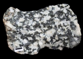
Diorite is an intrusive igneous rock formed by the slow cooling underground of magma that has a moderate content of silica and a relatively low content of alkali metals. It is intermediate in composition between low-silica (mafic) gabbro and high-silica (felsic) granite.

Ami Boué was a geologist of French Huguenot origin. Born at Hamburg, he was trained in Edinburgh and across Europe. He travelled across Europe, studying geology, as well as ethnology, and is considered to be among the first to produce a geological map of the world.

Albert Auguste Cochon de Lapparent was a French geologist.

Jean Baptiste Julien d'Omalius d'Halloy was a Belgian statesman and geologist. He was the first to define the Cretaceous as a distinct geological period, in 1822. He produced the first geological map of France, the Benelux, the Rhineland and Switzerland, completed in 1813 and published in 1822. Halloysite, a clay mineral, was named in his honour. He also wrote on races.

Eugène Renevier was a Swiss geologist.

Jakob Johannes Sederholm was a Finnish petrologist most associated with his studies of migmatites.
Geologic mapping of Georgia is the creation of geologic maps—special-purpose maps made to show geological features—of the State of Georgia in the United States. Rock units or geologic strata are shown by colors or symbols to indicate where they are exposed at the surface. Structural features such as faults and shear zones are also shown. Since the first national geological map, in 1809, there have been numerous maps which included the geology of Georgia. The first Georgia-specific geologic map was created in 1825. The most recent state-produced geologic map of Georgia, by the Georgia Department of Natural Resources is 1:500,000 scale, and was created in 1976 by the department's Georgia Geological Survey. It was generated from a base map produced by the United States Geological Survey. The state geologist and Director of the Geological Survey of Georgia was Sam M. Pickering, Jr. Since 1976, several geological maps of Georgia, featuring the state's five distinct geologic regions, have been produced by the federal government.
A Veiki moraine is a type of moraine found in northern Sweden, Finnmark in Norway, and parts of Canada. This moraine is characterized by forming a hummocky landscape of irregular moraine plateaus with elevated rims that are intercalated with ponds. Gunnar Hoppe was the first to define the Veiki moraine concept in 1952, naming it after a locality consisting of two farms located about 10 kilometers north of Gällivare and Malmberget. To the east in Finnish Lapland, a moraine type similar to Veiki moraine but smaller is known as Pulju moraine since 1967.
A Pulju moraine is a type of moraine found in northern Finland. Pulju moraines were first identified as distinct moraine type in 1967 by Finnish geologist Raimo Kujansuu who noticed moraines that resembled Veiki moraines as those described by Gunnar Hoppe in 1952 but were smaller. Raimo Kujansuu described Pulju moraines with the following words:
...consists of small hummocks, often only from one to five meters high, or of ridges of the same height and between 50 and 300 meters long, which are situated helter-skelter or in thick clusters running either parallel to the movement or margin of the ice sheet or crossvalleywise. In many spots one also meets with ring ridges, measuring no more than 50 to 150 meters in diameter. The slopes are gentle and the hollows between the ridges are mostly filled with peat.
The Société géologique de France (SGF) is a French learned society founded on 17 March 1830. As of 2006, it counts 1,200 members.

Henri Fontaine, was a French Roman Catholic missionary. He was also a pre-Tertiary geologist/paleontologist, Paleozoic corals specialist, and archaeologist.
Hoàng Thị Thân is the first woman to graduate from the Department of Geological Engineering of Laval University, the first female Vietnamese geological engineer and archeologist. She is also a boat person.

Marie-Henriette Alimen was a French paleontologist and geologist. Alimen studied at École Normale Supérieure, later going on to teach at Musée de l'Homme, and serve as president of Société géologique de France. Alimen's career was mainly focused on Quaternary geology in France and Africa while working for Centre national de la recherche scientifique. She later became a Knight of both the Legion of Honour and the Ordre des Palmes Académiques.
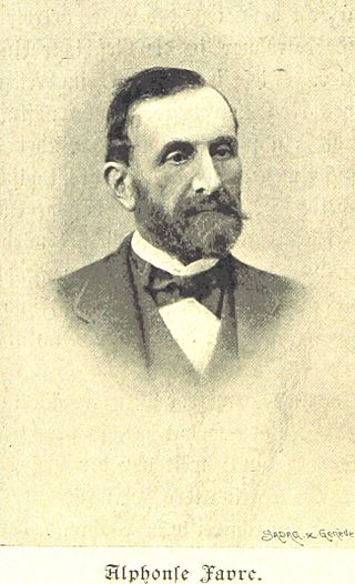
Jean Alphonse Favre was a Swiss geologist. He was a pioneer of alpine geology and became director of the Swiss Geological Commission (Schweizerische Geologische Kommission), which was charged with creating the geological map of Switzerland.
Bulletin of the Geological Society of Finland is a peer-reviewed open access scholarly journal publishing research articles and short communications in all branches of geosciences. It the official journal of the Geological Society of Finland. The current editor-in-chief is Dr. Niina Kuosmanen. From 1929 to 1967, it was known as Comptes Rendus de la Société Géologique de Finlande before changing to the current name from Volume 40 onwards to the present day.

The Commission for the Geological Map of the World is an international association in the field of geology. Its main role is the production of small-scale geological or geoscience-related maps of the globe, or parts of the globe. It is an organization affiliated to the IUGS International Union of Geological Sciences (IUGS) and International Union of Geodesy and Geophysics (IUGG) and is a UNESCO-related scientific NGO.
Gilles Joseph Gustave Dewalque was a Belgian physician, geologist, paleontologist, and mineralogist.
Henri Schoeller was an influential French geologist and hydrogeologist.