The Department of Natural Resources, operating under the FIP applied title Natural Resources Canada (NRCan), is the ministry of the government of Canada responsible for natural resources, energy, minerals and metals, forests, earth sciences, mapping and remote sensing. It was created in 1995 by amalgamating the now-defunct Departments of Energy, Mines and Resources and Forestry. Natural Resources Canada (NRCan) works to ensure the responsible development of Canada's natural resources, including energy, forests, minerals and metals. NRCan also uses its expertise in earth sciences to build and maintain an up-to-date knowledge base of our landmass and resources. To promote internal collaboration, NRCan has implemented a departmental wide wiki based on MediaWiki. Natural Resources Canada also collaborates with American and Mexican government scientists, along with the Commission for Environmental Cooperation, to produce the North American Environmental Atlas, which is used to depict and track environmental issues for a continental perspective.
A geological survey is the systematic investigation of the geology beneath a given piece of ground for the purpose of creating a geological map or model. Geological surveying employs techniques from the traditional walk-over survey, studying outcrops and landforms, to intrusive methods, such as hand augering and machine-driven boreholes, to the use of geophysical techniques and remote sensing methods, such as aerial photography and satellite imagery. Such surveys may be undertaken by state, province, or national geological survey organizations to maintain the geological inventory and advance the knowledge of geosciences for the benefit of the nation. A geological survey map typically superimposes the surveyed extent and boundaries of geological units on a topographic map, together with information at points and lines. The maps and reports created by geological survey organisations generally aim for geographic continuity and completeness in establishing the spatial patterns of near-surface rock units. The map may include cross sections to illustrate the three-dimensional interpretation. Subsurface geological and geophysical maps, providing limited coverage of deeper geology, are maintained internally by major oil companies and regulators. Some geological survey organisations have collaborated with them to include subsurface geology in their systematic surveys, for example, the Geological Atlas of the Western Canada Sedimentary Basin. Subsurface maps typically depict the three-dimensional form of geological surfaces by means of contours and cross sections. Computer-based models are increasingly used to provide more comprehensive information storage and greater flexibility of presentation. In the United States, the 50 state surveys are coordinated by the Association of American State Geologists.

The California Geological Survey, previously known as the California Division of Mines and Geology, is the California state geologic agency.

Geoscience Australia is an agency of the Australian Government. It carries out geoscientific research. The agency is the government's technical adviser on all aspects of geoscience, and custodian of the geographic and geological data and knowledge of the nation.

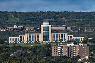
The Confederation Building serves as the home of the Newfoundland and Labrador House of Assembly. It is located on Confederation Hill overlooking Newfoundland and Labrador's capital city, St. John's. The brick- and concrete-clad building has 11 storeys and is 64 metres (210 ft) tall. It was completed in 1960 at a cost of $9 million to replace the Colonial Building. A lantern is located at the top of the copper roof of the central tower and acts as a beacon when turned on at night.

The Geological Survey of Pakistan, is an attached department under the Ministry of Energy . Basic mandate of GSP is to explore the mineral resources of Pakistan. Main tasks GSP perform are Geological, Geophysical and Geo-chemical Mapping of Pakistan. Target of these mapping are mineral exploration, Geo-Technical/Engineering assessment, Geo-hazard prediction/prevention and addressing environmental issue.
The Utah Geological Survey is based in Salt Lake City, Utah, United States. It also has an office in Cedar City, Utah.
The Geological Association of Canada (GAC) is a learned society that promotes and develops the geological sciences in Canada. The organization holds conferences, meetings and exhibitions for the discussion of geological problems and the exchange of views in matters related to geology. It publishes various journals and collections of learned papers dealing with geology.

A geologist is a scientist who studies the solid, liquid, and gaseous matter that constitutes the Earth and other terrestrial planets, as well as the processes that shape them. Geologists usually study geology, although backgrounds in physics, chemistry, biology, and other sciences are also useful. Field work is an important component of geology, although many subdisciplines incorporate laboratory work.

The Mines and Geo-sciences Bureau (MGB) is a government agency of the Philippines under the Department of Environment and Natural Resources (DENR). The MGB( is responsible for the conservation, management, development and use of the country's mineral resources, including those in reservations and lands of public domains.

The Delaware Geological Survey (DGS) is a scientific agency for the State of Delaware, located at the University of Delaware (UD), that conducts geologic and hydrologic research, service, and exploration. The mission of the DGS is to provide objective earth science information, advice, and service to citizens, policy makers, industries, and educational institutions of Delaware. The DGS became formally affiliated with the university's College of Earth, Ocean, and Environment (CEOE) in July 2008. Most DGS scientists have secondary faculty appointments in the College's Department of Geological Sciences.

The Michigan Geological Survey is a scientific agency of the U.S. state of Michigan. The survey is headed by the State Geologist of Michigan.

The Renews Head Formation is a geologic formation in Newfoundland and Labrador. It preserves fossils dating back to the Ediacaran period.
The Central Mineral Belt is a geologically defined area of Labrador in northeastern Canada, forming a part of the Canadian Shield. It is important as a source of iron ore, uranium and other minerals.
Rex Vincent Gibbons is a geologist, educator and former politician in Newfoundland. He represented St. John's West in the Newfoundland House of Assembly from 1989 to 1997.
Carolyn Relf is a Canadian geologist. She has served as director of the Yukon Geological Survey, project geologist with the Government of the Northwest Territories, chief geologist with Indigenous and Northern Affairs Canada, federal co-manager of the Northwest Territories' Geoscience Office, director of the Mineral and Petroleum Resources for Indian and Northern Affairs Canada, as well as adjunct professor at the University of Alberta.

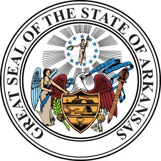
The Arkansas Geological Survey (AGS), formerly the Arkansas Geological Commission (AGC), is a government agency of the State of Arkansas. It is responsible for the investigation of the geology, geologic processes, and geologic resources within the state. It encourages the considered management and utilization of the state's mineral, fossil-fuel, and water resources with attention to the potential environmental issues of that activity.

The Colombian Geological Survey (CGS) is a scientific agency of the Colombian government in charge of contributing to the socioeconomic development of the nation through research in basic and applied geosciences of the subsoil, the potential of its resources, evaluating and monitoring threats of geological origin, managing the geoscientific knowledge of the nation, and studying the nuclear and radioactive elements in Colombia.
The Geological Survey of Queensland (GSQ) is the Australian state of Queensland's government body responsible for the management of geoscience knowledge. It is a unit within the Government of Queensland's Department of Natural Resources, Mines and Energy.


