![]() | This article has multiple issues. Please help improve it or discuss these issues on the talk page . (Learn how and when to remove these messages)
|
(in German) Bundesamt für Landestopografie (in French) Office fédéral de topographie (in Italian) Ufficio federale di topografia (in Romansh) Uffizi federal da topografia | |
![]() | |
![]() Building in Wabern. | |
Agency overview | |
---|---|
Jurisdiction | Federal administration of Switzerland |
Headquarters | Wabern |
Minister responsible | |
Parent agency | Federal Department of Defence, Civil Protection and Sports |
Website | www.swisstopo.admin.ch |
Swisstopo is the official name for the Swiss Federal Office of Topography, [a] Switzerland's national mapping agency.
The current name was made official in 2002. It had been used as the domain name for the homepage of the institute, swisstopo.admin.ch, since 1997. [1]
The main class of products produced by Swisstopo are topographical maps on seven different scales. Swiss maps have been praised for their accuracy and quality. [2]
The numbering system of Swiss regular maps (apart from composites) is directly based on the geographical situation. A map number is always one higher than the map number of the adjacent map to the west, and one lower than the adjacent map to the east. From north to south, the numbers differ by 20 for the scale 1:25.000, 10 for the scale 1:50.000 and 5 for the scale 1:100.000. However, as can be seen on the Seite nicht gefunden, [3] there are some exceptions to this rule: Switzerland is a little bit too large to be only 20 1:25.000 maps wide. Instead of choosing another system, the map to the east of 1199 Scuol is called 1199bis Piz Lad. The same is true for some maps at scale 1:50.000.
In 1809, the first topographical surveys of Switzerland took place on a confederate, military level. They took place in the north-eastern area and were led by Hans Conrad Finsler. Measurements in the alpine region started in 1825 with triangulations by Antoine-Joseph Buchwalder. This work would be finished in 1837 by Johannes Eschmann. At New Year 1838, the Topographical Bureau (Eidgenössisches Topographisches Bureau) was founded in Carouge, Geneve by Guillaume Henri Dufour. This bureau published its first map the same year, the Carte topographique du Canton de Genève. Topographic surveys also started in the alpine regions of Switzerland. These had their first results in 1845, a year later than planned, when a map scaled 1:100.000 was published. This was the start of what are termed Dufourkarten (Dufour's Maps). The topographic survey finished in 1862. To honour Dufour, the Swiss government decided to rename the highest peak on the Dufourkarten from Höchste Spitze to Dufourspitze: it still carries that name today. In 1863, the SAC published a 1:50.000 map of the region Tödi, based on unpublished survey material. A year later, the last map of the Dufourkarten was published, and the following year, Dufour retired and Hermann Siegfried became Chief of the Topographical Bureau.
In 1865, Herman Siegfried becomes the Chief of the Topographical Bureau, and the bureau moves from Geneva to Bern. Over the next few years, a composite map is published of Ticino, soundings start to measure the depth of the major Swiss lakes, and a first map is published scaled 1:250.000. In 1868, a Federal Act is passed to enforce the continuation of the initial topographic surveys, as well as the publication of the results. This results in new topographical surveys in 1869 and the publication of the first 13 Siegfriedkarten (1:25.000 and 1:50.000) in 1870. In 1878, a 1:1.000.000 map is published, and the next year, the height of the Pierre du Niton is measured to be 376.86 metre. In 1880, Herman Siegfried is succeeded by Jules Dumur.
In 1895, the Topographical surveys for the Siegfriedkarten are finished. As of 1901, 581 sheets of the Siegfriedkarten have been published, with only a few individual more maps to come (there would be 604 maps in 1926). On old maps of the modern series, a reference to those maps can still be found: until the 1970s, the Siegfriedkarte was the best scale available for some areas of Switzerland, and therefore used by climbers and other alpinists. The printing of the Siegfriedkarten would continue until 1952.
In 1887, the first maps with relief shading are published. In 1889, a photographic studio is appended to the bureau. In the years after 1894, a wall-map for schools is published, in response to a request from the parliament to do so. In 1898, the soundings of the major Swiss lakes are finished. In 1901, the bureau is moved into an independent division within the military, and the name Eidgenössische Landestopographie becomes customary, a name still used by some people until today, and a name which can be found on some older maps. Hermann Kümmerly publishes a relief wall-map for schools in the same year. In 1908, map trials are started to serve as a replacement for the Dufourkarten. Two years later, trials start to replace the Siegfriedkarten. Much of this military work would remain secret for many years. In 1913, 1922 and 1924, trials are done with aerial photogrammetry, first with balloons and later with aircraft, but only as of 1930 this is used for production of maps, and in 1940 terrestrial photogrammetry is abandoned.
On 21 June 1935, a Federal Act was passed on the production of the new National Map series, ranging in scale from 1:25.000 to 1:1.000.000. Because of the political situation in Europe, work was started on the 1:50.000 maps.[ clarification needed ] For this purpose, a 'M18d' Messerschmitt was bought for aerial photography, the first aircraft owned by the Eidgenössischie Landestopographie. In 1938, the first 1:50.000 map was published: 263 Wildstrubel. From 1939 to 1945, all sales were suspended because of World War II. In 1939, the Eidgenössische Landestopographie also procured its first vehicle.
The first 1:25:000 map, 1145 Bielersee, was published in 1952. The last 1:25.000 map, 1292 Maggia, was published in 1979. This marked the finish of the lowest-scale mapping of Switzerland. The first composite in this scale, 2501 St. Gallen, was published in 1956.
The 1:50.000 series was completed in 1963 with 285 Domodossola. With the publication of this map, the Siegfriedkarten have been entirely replaced. The first composite on this scale, 5001 Gotthard, was published in 1954.
The 1:100.000 series started with 41 Col du Pillon (1954), and finished with 47 Monte Rosa in 1965. With this publication, the Dufourkarten have been entirely replaced.
The 1:200.000 series started with No. 3 in 1971 and finished with No. 4 in 1976.
The maps on the scales 1:500.000 and 1:1.000.000 were respectively first published in 1965 and 1994. With the publication of the latter map, the work required by the Federal Act of 1935 was finally finished.
Since 1951, different sorts of leisure maps have been published by the Federal Office of Topography. See above for a list of those.
In 1958, the coordinate system of the maps was changed. Before 1958, the centre of the coordinate system, Bern, had coordinates (0, 0). Subsequently, it has coordinates (600, 200). This was done so that any coordinate is either an x-coordinate or a y-coordinate: this prevents confusion about the order of the coordinates.
In 1968, the name officially became Eidgenössische Landestopographie instead of Abteilung für Landestopographie, although this had been common practice for decades. The English name remained unchanged (Topographical Survey of Switzerland).
In 1979, the Eidgenössische Landestopographie was renamed to the current name Bundesamt für Landestopographie. See above for the names in other languages. Since 2002, the international name Swisstopo has been used. This name had already been used since the website www
Some maps produced by Swisstopo scarcely have any Switzerland on it. This is especially true for the scales 1:100.000 and 1:50.000. As can be seen here, the map 45 Haute Savoie only has a very little spot of Switzerland on it, in the extreme north-western corner. The same is true for the 1:50.000 map 285 Domodossola. In both cases, no 1:25.000 maps have been published for the corresponding part of the 1:50.000 map: at the 1:25.000 scale, some maps are a tiny bit larger than others, to be able to get all of Switzerland onto a map without the need of maps with less than 0.1% domestic territory on it.
Initially, the plan was to be more generous also for 1:25.000 maps. Thirty-one maps were once planned, most of which did not have a single km^2 Switzerland on it, that were never published. Some of them (1158 Zeinisjoch) were up to ten kilometers away from the Swiss border. On old Swiss maps, one can still see the Blattübersicht were those are signified as planned maps.
Some maps have been published in the past, but have been discontinued, also because they lack any part of Switzerland. 1035 Friedrichshafen is an example of that. When one looks at the Mapsheet Index Northeast, there is no map to the east or to the north of 1055 Romanshorn. However, when one then looks at the area of 1055 Romanshorn, it can be seen that these maps do in fact exist, but do not have any Swiss land on the map.
In modern mapping, a topographic map or topographic sheet is a type of map characterized by large-scale detail and quantitative representation of relief features, usually using contour lines, but historically using a variety of methods. Traditional definitions require a topographic map to show both natural and artificial features. A topographic survey is typically based upon a systematic observation and published as a map series, made up of two or more map sheets that combine to form the whole map. A topographic map series uses a common specification that includes the range of cartographic symbols employed, as well as a standard geodetic framework that defines the map projection, coordinate system, ellipsoid and geodetic datum. Official topographic maps also adopt a national grid referencing system.
Guillaume Henri Dufour was a Swiss military officer, structural engineer and topographer. He served under Napoleon I and held the Swiss office of General four times in his career, firstly in 1847 when he led the Swiss Confederation forces to victory against the Sonderbund. In 1864 Dufour presided over the First Geneva Convention which established the International Red Cross. He was founder and president of the Swiss Federal Office of Topography.
The Swiss coordinate system is a geographic coordinate system used in Switzerland and Liechtenstein for maps and surveying by the Swiss Federal Office of Topography (Swisstopo).
Smith Island is 20 miles (32 km) long and 5 miles wide, lying 49 miles (79 km) west of Deception Island in the South Shetland Islands of the British Antarctic Territory. It is separated from Snow Island by the 25 miles (40 km)-wide Boyd Strait, and from Low Island by the 17 miles (27 km)-wide Osmar Strait. Surface area is 148 square kilometres (57 sq mi).
Perunika Glacier is an 8 km long and 3 km wide (average) roughly crescent-shaped glacier in eastern Livingston Island in the South Shetland Islands, Antarctica situated east of Pimpirev Glacier, south of Saedinenie Snowfield, southwest of Kaliakra Glacier, west of Huron Glacier, and north of Balkan Snowfield and the head of Huntress Glacier.
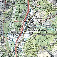
The cartography of Switzerland is the history of surveying and creation of maps of Switzerland. Switzerland has had its current boundaries since 1815, but maps of the Old Swiss Confederacy were drawn since the 16th century. The first topographical survey on a federal level began in 1809, resulting in the Topographic Map of Switzerland or Dufour Map. From 1869 to 1901, this map was replaced by the Topographic Atlas of Switzerland or Siegfried Map.
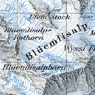
The National Maps of Switzerland, also referred to as the Swisstopo maps, are a set of official map series designed, edited and distributed by Swisstopo, the Swiss Federal Office of Topography. Each map series is based on an oblique, conformal, cylindrical projection, with a Swiss Coordinate system. All maps are updated in a complete cycle of about six years.
The Dunantspitze, formerly called Ostspitze, is a peak of the Monte Rosa Massif in the Pennine Alps in Switzerland. It is the second highest peak of the massif, after the Dufourspitze (4,634 m) and the second highest summit in Switzerland, but its prominence is only about 15 metres. At the time of its first ascent it was unclear which of the summits was the higher.
The Bürgenstock is a mountain in Switzerland with an elevation of 1,128 m (3,701 ft) above sea level, situated beside Lake Lucerne. Since the late 19th century, the Bürgenstock is the site of a large hotel and conference centre, today known as Bürgenstock Resort, situated some 600 m (2,000 ft) above Lake Lucerne.
A national mapping agency (NMA) is an organisation, usually publicly owned, that produces topographic maps and geographic information of a country. Some national mapping agencies also deal with cadastral matters.
Metres above the Sea is the vertical datum used in Switzerland. Both the system and the term are also used in the Principality of Liechtenstein.
The Topographic Atlas of Switzerland, also known as the Siegfried Atlas or Siegfried Map, is an official map series of Switzerland. Its publication was begun by the Federal Topographic Bureau under Hermann Siegfried, and continued from 1870 to 1926. During this period the individual maps were drawn by different lithographers, including Walter Hauenstein, Georg Christian von Hoven and Rudolf Leuzinger. Since it is, in today's parlance, not strictly an atlas but a map series, map historians now describe it only by the expression Siegfried Map.
A map series is a group of topographic or thematic charts or maps usually having the same scale and cartographic specifications, and with each sheet appropriately identified by its publisher as belonging to the same series.
The Topographic Map of Switzerland, also known as the Dufour Map is a 1:100 000 scale map series depicting Switzerland for the first time based on accurate geometric measurements. It is also the oldest official map series of Switzerland.
Roché Glacier is the 5.8 km long and 2 km wide glacier draining the central part of Vinson Plateau in Sentinel Range, Ellsworth Mountains in Antarctica. Its head is bounded by Mount Vinson to the north, Corbet Peak and Clinch Peak to the east, Wahlstrom Peak to the southeast, and Hollister Peak to the south, with the glacier flowing westwards and descending steeply north of Silverstein Peak to join Branscomb Glacier.
Hoek Glacier is a glacier flowing into Dimitrov Cove northeast of Veshka Point on the northwest coast of Velingrad Peninsula on Graham Coast in Graham Land, Antarctica, southward of the Llanquihue Islands. It was charted by the British Graham Land Expedition under John Rymill, 1934–37, and was named by the UK Antarctic Place-Names Committee in 1959 for Henry W. Hoek (1878–1951), a pioneer Swiss ski-mountaineer and author of one of the earliest skiing manuals.
Rudolf Leuzinger was a Swiss cartographer. He is known as one of the most prolific cartographers in Switzerland and one of the best interpreters of mountain landscapes and geologic forms. Leuzinger was also the first to produce terrain maps in color lithography. His more than 300 maps are a rare combination of accuracy, scientific thoroughness and artistry and earned him several national and international honors.