Hurricane Ike

Last updated

Map key
  Tropical depression (≤38 mph, ≤62 km/h)
  Tropical storm (39–73 mph, 63–118 km/h)
  Category 1 (74–95 mph, 119–153 km/h)
  Category 2 (96–110 mph, 154–177 km/h)
  Category 3 (111–129 mph, 178–208 km/h)
  Category 4 (130–156 mph, 209–251 km/h)
  Category 5 (≥157 mph, ≥252 km/h)
  Unknown
Storm type
Disc Plain black.svg Tropical cyclone
Solid black.svg Subtropical cyclone
ArrowUp.svg Extratropical cyclone, remnant low, tropical disturbance, or monsoon depression

The origins of Hurricane Ike can be traced back to a well-defined tropical wave first identified by the National Hurricane Center  (NHC) just within the western coast of Africa on August 28. [7] [8] Despite the development of a low-pressure area associated with the wave and signs of organization within favorable conditions near the Cape Verde Islands, [9] the system was only able to generate intermittent thunderstorm activity. The broad low-pressure continued to track westward and was considered to have become sufficiently organized to be classified as a tropical depression at 06:00  UTC on September 1. By this time the cyclone had tracked 780 miles (1,260 kilometers) west of Cape Verde. Although post-analysis indicated that the depression reached tropical storm strength at 12:00 UTC that day, [10] operationally the NHC began issuing advisories on Ike three hours later, by which time the system had already gained numerous curved rainbands and well-established outflow. [11] Over the next few hours, Ike developed additional rainbands, [12] but failed to develop a centralized area of convection due to the presence of dry air to the storm's south and its location in an area with only marginally favorable sea surface temperatures. [13] These factors were also responsible for Ike's slow developmental trend that began after formation. [10]

Meteorological prediction of Ike's path on September 3, 2008 234613W sm.gif
Meteorological prediction of Ike's path on September 3, 2008

Ike's gradual strengthening began to quicken early on September 3, with the strengthening of an intense rainband around the center of the storm. At roughly 15:00 UTC that day, microwave imaging indicated that a primordial eye was developing within the intensifying tropical storm. [10] Tracking northwestward, the NHC upgraded Ike to hurricane status at 18:00 UTC based on objective satellite intensity estimates and the appearance of the eye on visible satellite imagery. [10] [14] During this time, Ike was centered 690 mi (1,110 km) east-northeast of the Leeward Islands and was tracking west-northwestward as a result of a weakened subtropical ridge to its northeast. [10] Ike's placement in an area with virtually no wind shear allowed for the hurricane to undergo explosive intensification despite unfavorable upper-level winds to its north, [14] reaching major hurricane strength six hours after its designation as a hurricane. [15] At 06:00 UTC on September 4, Ike peaked with maximum sustained winds of 145 miles per hour (233 kilometers per hour) and a minimum barometric pressure of 935 millibars (27.6 inches of mercury ), making the storm a Category 4 on the Saffir–Simpson hurricane wind scale. After peaking in strength, a ridge of high pressure to the storm's west strengthened, causing Ike to track towards the southwest—a path unusual for the time of year. However, this track also brought the storm into an area of strong wind shear, [10] causing the storm to become asymmetric in structure late on September 4 and weaken, [16] briefly dropping below major hurricane status on September 6 while 150 miles (240 km) east of Grand Turk Island. [17] Although wind shear abated and allowed for reintensification, Ike would fluctuate in strength over the next few days. After passing near the Turks and Caicos Islands, Ike made its first landfall on Inagua in the Bahamas at 13:00 UTC on September 7 with winds of 125 mph (201 km/h). [18]

After passing over Inagua, [18] the development of a double eyewall—a feature that usually denotes the beginning of an eyewall replacement cycle—slightly weakened Ike late on September 7. [19] However, the hurricane was able to reintensify and reach Category 4 intensity for a final time before making landfall near Cabo Lucrecia on the coast of Holguín Province in Cuba by 00:00 UTC the next day. [18] Although Ike remained well-defined for most of its crossing of eastern Cuba, [20] the hurricane's core had become disrupted by the time it had reached the Caribbean Sea after spending a few hours over land. [21] Over the next day, Ike tracked westward, paralleling the southern coast of Cuba without much intensification; at times the center of the hurricane was within 12 mi (19 km) of the island. At around 14:00 UTC on September 9, Ike made a second Cuban landfall, this time on Punta La Capitana in Pinar del Rio, with winds of 80 mph (130 km/h). Roughly six hours later, the hurricane emerged into the Gulf of Mexico as a slightly weakened system. [18]

Despite tracking back over water, Ike's prolonged interaction with Cuba had greatly disrupted the system's core, and instead of quickly strengthening and coalescing, the storm's wind field instead grew and only gradual intensification ensued. [18] Due to the storm's comparatively small inner core and intensity of the outer rainbands, [22] an eyewall replacement cycle took place, preventing Ike from rapidly intensifying. At around the same time, a high-pressure area strengthened to the hurricane's north, steering the cyclone further west than initially anticipated. Moving over the warm waters of the Loop Current, [18] Ike reached a secondary minimum in barometric pressure on 00:00 UTC with an estimate of 944 mbar (27.9 inHg); though winds would continue to strengthen afterward, the storm's pressure would rise. [23] By late on September 12, Ike had reached the western edge of the nearby high-pressure area and began to curve northward. The formation of an eye just prior to landfall resulted in a slight increase in winds, [18] and at 0700 UTC on September 13, Ike made landfall on the northeast end of Galveston Island in Texas, with a minimum barometric pressure of 950 mbar (28 inHg) and sustained winds of 110 mph (180 km/h), making Ike a Category 2 hurricane. [23] After tracking inland, Ike weakened as it sped northward and later northeastward, weakening to tropical storm status east of Palestine, Texas late on September 13 and later becoming a powerful extratropical cyclone on September 14 over the Ozarks. [18] A more steady weakening phase ensued, and after tracking across southern Ontario and Quebec, the remnants of Ike were absorbed by another extratropical low near the St. Lawrence River, on September 15. [24]

Preparations

Turks and Caicos Islands and The Bahamas

Hurricane Ike approaching Cuba as a Category 4 hurricane Ike 2008-09-07 1825Z.jpg
Hurricane Ike approaching Cuba as a Category 4 hurricane

Fearing a repeat of Hurricane Donna in 1960, the overseas branch of the British Red Cross began preparing contingency plans for 2,000 families considered to be at risk from Ike. A group of 260 Chinese construction workers stuck on Middle Caicos after the passage of Hurricane Hanna were evacuated by the British Red Cross. [25] Immediately before the storm struck, 348 people on Grand Turk were put into emergency shelters. [26]

Florida

A Florida Army National Guardsman uses a Single Mobile User Case Set to send a situation report on ongoing preparations for Hurricane Ike in Key West, Florida. USArmyHurricaneIke.jpg
A Florida Army National Guardsman uses a Single Mobile User Case Set to send a situation report on ongoing preparations for Hurricane Ike in Key West, Florida.

On September 5, Florida Governor Charlie Crist declared a state of emergency in advance of Ike's arrival, (which was expected to be as early as September 8). Authorities in Key West issued a mandatory evacuation for all visitors for September 6. The Federal Emergency Management Agency (FEMA) positioned supplies, and emergency response crews in Florida and along the Gulf Coast.

Florida Keys officials began evacuations on the low-lying chain of islands in phases, starting at the end in Key West by 8 am Sunday and continuing throughout the day—at noon for the Middle Keys, and at 4 pm for the Upper Keys, including Key Largo. Visitors were told to leave on Saturday. [27] Overall 15,000 tourists evacuated, but the storm stayed to the south, only causing minor beach erosion. [1]

Texas

A US-Air Force Staff Sergeant receives a hug from a resident after Hurricane Ike, September 13, 2008. After Hurricane Ike in Texas.jpg
A US-Air Force Staff Sergeant receives a hug from a resident after Hurricane Ike, September 13, 2008.

On September 7, The Texas Water/Wastewater Agency Response Network (TXWARN) [28] activated its 700-member utility mutual aid network and began coordination with the State Emergency Operations Center and the Texas Commission on Environmental Quality (TCEQ) to begin preparations and notifications to utilities to prepare for Ike. [29] State rural water associations activated mutual aid networks to prepare for the landfall of Ike while still providing assistance to areas affected by Hurricane Gustav. [30] [31] The Texas Rural Water Association held meetings with state agencies on September 9, to plan for landfall along the Texas Gulf Coast. [32] [33]

On September 11, forecasting models began to show Ike making landfall just south of Galveston. City Manager Steven LeBlanc late Wednesday issued a mandatory evacuation order for the low-lying west end of Galveston Island. [34] Later, the mandatory evacuation order was extended to the entire island of Galveston, as well as low-lying areas around Houston, Texas. [35] Mandatory evacuations were also ordered for Jefferson, Orange, and Chambers counties located east of Houston. Voluntary evacuations were in effect for Hardin and Tyler as well as Newton and Jasper counties. [36] Residents evacuating ahead of Ike were received by emergency workers in the Dallas/Fort Worth(DFW) Metroplex where they were provided a place of refuge, medical treatment, and provisions. In addition to the orders of local and state officials, federal officials were thoroughly involved in evacuation decisions. On September 10, U.S. President George W. Bush made an emergency declaration for Texas, making more federal help available for preparations and evacuations. [37] More than one million people evacuated in advance of Hurricane Ike, but more than 100,000 people did not. [38]

At 8:19 pm (CDT) September 11, the National Weather Service in Houston/Galveston, Texas issued a strongly worded bulletin, regarding storm surge along the shoreline of Galveston Bay. The bulletin advised that residents living in single-family homes in some parts of coastal Texas faced "certain death" if they did not heed orders to evacuate. [39] [40] [41] Reports said as many as 40 percent of Galveston's citizens did not pay attention to the warnings. [42] It was feared to be much the same in Port Arthur, and it was predicted that low-lying areas between Morgan City, Louisiana and Baffin Bay, Texas, particularly those areas east of Ike's projected eye landfall would experience the greatest damage from storm surges of up to 20 feet (6.1 m). [43]

The price of gas increased in the expectation of damage to some of the numerous oil refineries along the South Texas coast, or at least delays in production from the oil and gas platforms in the Gulf of Mexico. [44] 14 oil refineries shut down production and nearly 150 oil tankers and cargo ships waited off-shore as every port from Lake Charles, Louisiana to Corpus Christi, Texas shut down in preparation for the storm. [1]

Impact

Hurricane Ike
Ike 2008-09-04 1440Z.jpg
Ike near peak intensity, northeast of the Leeward Islands on September 4
IBTrACS OOjs UI icon edit-ltr-progressive.svg
Fatalities by country [1]
CountryDeathsMissing
Haiti 74N/A
Dominican Republic 2N/A
Cuba 7N/A
United States11316
Total19616

Turks and Caicos Islands and The Bahamas

Numerous hurricane-damaged houses, buildings, and structures were still to be found in early January 2009 on Grand Turk. Caribbean winter 2008 2009 2 969.JPG
Numerous hurricane-damaged houses, buildings, and structures were still to be found in early January 2009 on Grand Turk.

Power was lost throughout Grand Turk Island, an estimated 80%–95% of the houses there were damaged, 20% of which was a total loss. [1] [26] [46] There was also significant structural damage to roofs and buildings containing health services resulting in the disruption of most health services. [26] The local pharmacy roof collapsed, destroying the area's prescription drug supply, the police station, and the prison was significantly damaged and local supplies facilities were either damaged or destroyed. [26] A two-year-old cruise ship terminal on Grand Turk owned by Carnival Cruise Lines was significantly damaged. [1] Water and electricity were also disrupted but since have been restored.[ citation needed ] Meanwhile, in South Caicos, 95% of the houses were also damaged, with over one-third significantly damaged or destroyed. Damage also occurred on other islands, mostly agricultural or the fishing industry, but in general, the damage was minor. [1]

Buildings on the islands have been severely weakened and 750 people have lost their homes. [47] Due to the extent and magnitude of damage and affected the population, the Government of the Turks and Caicos declared Grand Turk and South Caicos Islands disaster areas.

In Great Inagua Island, The Bahamas, eighty percent of houses sustained damage with almost a third of them having significant damage. The local Morton Salt factory was damaged and shut down operations. [1] A few outlining islands suffered minor damage and no casualties were reported. Overall damage from the Turks and Caicos and The Bahamas was estimated between $50 million and $200 million. [1]

Haiti

The remains of a school in Port-au-Prince, Haiti on September 15, 2008 Destroyed school in Port-Au-Prince.jpg
The remains of a school in Port-au-Prince, Haiti on September 15, 2008

The outer bands of Ike caused additional flooding in Haiti, which was already devastated by Hanna and also hit hard by Fay and Gustav. The last bridge still standing into the city of Gonaïves was washed away, slowing relief in the community considerably and creating a deep humanitarian and food crisis in the hard-hit region. [1] [48] 74 deaths were reported in Haiti from Ike, most of which were in the coastal community of Cabaret which was swept away by floodwaters and mudslides. [1] [49] Haitian Prime Minister Michèle Pierre-Louis called for help at the end of the week, saying that four storms in three weeks have left over 550 dead and as many as one million homeless. [50] She also said that parts of Gonaïves were so severely damaged that the city may have to be rebuilt elsewhere. [50] Two additional deaths were reported in the Dominican Republic. [1]

Cuba

Costliest Cuban hurricanes
RankHurricaneSeasonDamageRefs
1 Irma 2017 $13.2 billion [51]
2 Ike 2008 $7.3 billion [52]
3 Matthew 2016 $2.58 billion [53]
4 Gustav 2008$2.1 billion [52]
5 Michelle 2001 $2 billion [54]
Sandy 2012 [55]
7 Dennis 2005 $1.5 billion [56]
8 Ivan 2004 $1.2 billion [57]
9 Charley 2004$923 million [57]
10 Wilma 2005$700 million [58]

About 2.6 million Cubans, a fourth of the population, were evacuated ahead of Ike. [59] In Baracoa, 200 homes were reported to be destroyed and waves were running 23 ft (7 m) high and peaked at 40 ft (12 m) in different areas of Cuba. The Category 4 hurricane made landfall on September 8 on the north coast of eastern Cuba in the province of Holguín near Puerto de Sama, with sustained winds of about 130 mph (209 km/h), [1] causing widespread flooding and damage to the eastern provinces. [1] It passed across the central provinces of Holguín, Las Tunas, and Camagüey, emerging over the sea to the south of Cuba during the day. Ike dropped to Category One intensity by the time it crossed the island. [60] It then followed the southern coast of Cuba and crossed the western end of the island in Pinar del Río Province, close to the path taken by Hurricane Gustav ten days previously. The western areas of Cuba, already devastated by just 10 days before Ike hit, suffered additional major flooding from the rain and storm surge. [2] The sugar cane crop was devastated, with over 3,400 square kilometres (1,300 sq mi) destroyed. The banana, yucca, coffee, and corn crops also suffered significant damage. [1] Alongside Gustav, they were described as the "worst ever" storms by Cuban officials. [61]

In total, seven people were killed in Cuba from Ike due to drowning or collapsing structures. [2] [1] Over 300,000 houses were damaged, with an estimated 43,000 a total loss. [1] The combined damage estimate from Ike and Gustav, and succeeding Paloma is about $9.7 billion (USD), with $7.3 billion of that from Ike, making Ike the most destructive hurricane in Cuban history at the time. It was later surpassed by Hurricane Irma almost exactly nine years later. [62]

United States

Radar animation of Ike at landfall Hurricane Ike NEXRAD radar animation.gif
Radar animation of Ike at landfall
Costliest U.S. Atlantic hurricanes [63] [64] [nb 2]
RankHurricaneSeasonDamage
1 3  Katrina 2005 $125 billion
 4  Harvey 2017
3 4  Ian 2022 $113 billion
4 4  Maria 2017 $90 billion
5 4  Ida 2021 $75 billion
6 ET  Sandy 2012 $65 billion
7 4  Irma 2017 $52.1 billion
8 2  Ike 2008 $30 billion
9 5  Andrew 1992 $27 billion
10 5  Michael 2018 $25 billion

Due to the intensity of the storm, Texas closed many of its chemical plants and oil refineries. Because much of the United States oil refining capacity is located in Texas, the closings caused a temporary increase in the prices of gasoline, home heating oil, and natural gas. [65] Increases were particularly high in North Carolina, especially in the mountains, where average prices were as much as 60 cents higher than the national average. [66] The closing of refineries so soon after Hurricane Gustav, and the time required to restart production, also resulted in shortages of gasoline in such places as the Carolinas and Tennessee, partly as a result of panic buying. [67] 113 direct and indirect deaths have been reported in the US, including 85 in Texas (18 direct), eight in Louisiana, one in Arkansas, two in Tennessee, one in Kentucky, seven in Indiana, four in Missouri, two in Illinois, two in Michigan, seven in Ohio and one in Pennsylvania. [1] As of August 2011, 16 people remain unaccounted for, 11 of them in the Galveston area. [1] On September 15, 2008, the United States Congress held a moment of silence for those who died in the hurricane.

MV Antalina

On September 11, the MV Antalina, a 584-foot (178 m) cargo ship, was among the ships that left Port Arthur to avoid the hurricane. The ship had a crew of 22 and carried a cargo of petroleum coke. On September 12, the ship's engine failed, and the ship was adrift 90 nautical miles (170 km) from the shore. The crew unsuccessfully attempted to repair the engine and requested to be evacuated by the Coast Guard, but the rescue mission was aborted because weather conditions were not within the safety parameters. The crew was forced to ride out the storm but kept in contact with the Coast Guard. [68] [69] The ship successfully rode out the storm and all 22 crew members were uninjured. On September 13, a tugboat was dispatched to return the vessel to port. [70]

Louisiana

A Coast Guard helicopter flying over New Iberia, Louisiana Hurricane Ike New Iberia.jpg
A Coast Guard helicopter flying over New Iberia, Louisiana

Ike's storm surge affected Louisiana well ahead of the hurricane's landfall in Texas. Areas in coastal south-central and southwestern Louisiana, some of which were flooded by Gustav, were re-flooded as a result of Ike. [71] Some areas that had not yet recovered from Gustav power outages received additional outages. [72] The hardest-hit areas were in and around Cameron Parish, with nearly every square inch of the coastline in that area was flooded heavily, reaching as far north as Lake Charles, nearly 30 miles inland. [1] Hundreds of people had to be rescued, [73] including 363 people who were rescued by Louisiana Department of Wildlife and Fisheries Search and Rescue teams in conjunction with the Louisiana National Guard and the U.S. Coast Guard. [74]

One person was killed in a flooded bayou in Terrebonne Parish, [75] and a wind-related death was reported near Houma. [76] Two other deaths took place in a car crash in the evacuation phase in Iberville Parish, [77] and two other storm-related deaths in Jefferson Davis Parish that were ruled as deaths by natural causes. [76]

Texas

Damage from Ike in Gilchrist, which was largely destroyed by the hurricane Hurricane Ike Gilchrist damage edit.jpg
Damage from Ike in Gilchrist, which was largely destroyed by the hurricane

On the morning of September 13, 2008, the eye of Hurricane Ike approached the upper Texas coast, making landfall at 2:10 am CDT over the east end of Galveston Island, with a high storm surge, and travelled north up Galveston Bay, along the east side of Houston [78] (see storm-path image ). People in low-lying areas who had not heeded evacuation orders, in single-family one- or two-story homes, were warned by the weather service that they faced "certain death" from the overnight storm surge. [41] Nearly 16,000 families in the Galveston-Houston area stayed in temporary shelters under federal housing programs, while 1700 were referred for assistance but could not be reached or were refused aid. [ citation needed ]

In regional Texas towns, electrical power began failing on September 12 before 8 pm CDT, [41] leaving millions without power (estimates range from 2.8 million [79] to 4.5 million [80] customers). Grocery store shelves in the Houston area were empty for weeks in the aftermath of the storm. [81]

Flood waters begin to rise in a neighbourhood of Bayou Vista, Texas. Hurricane Ike-38263.jpg
Flood waters begin to rise in a neighbourhood of Bayou Vista, Texas.

In Galveston, by 4 pm CDT (2100 UTC) on September 12, the rising storm surge began overtopping the 17 ft (5.2 m) Galveston Seawall, which faces the Gulf of Mexico; [41] waves had been crashing along the seawall earlier, from 9 am CDT. [82] Although Seawall Boulevard is elevated above the shoreline, many areas of town slope down behind the seawall to the lower elevation of Galveston Island.

Even though there were advance evacuation plans, Mary Jo Naschke, spokesperson for the city of Galveston, estimated that (as of Friday morning) a quarter of the city's residents paid no attention to calls for them to evacuate, despite predictions that most of Galveston Island would suffer heavy flooding from storm tide. [82] By 6 pm Friday night estimates varied as to how many of the 58,000 residents remained, but the figures of remaining residents were in the thousands. [83] Widespread flooding included downtown Galveston: [78] six feet (1.8 m) deep inside the Galveston County Courthouse, and the University of Texas Medical Branch, the primary hospital in Galveston county, was dealt significant damage due to flooding. The wide-scale flooding caused failures to all the facilities systems and allowed mold to invade all the buildings. [84] Tourist attractions on the island suffered various degrees of damage. The Lone Star Flight Museum suffered massive damage, as the storm surge washed through the airport and hangars with about 8 feet (2.4 m) of water; however, Moody Gardens was built with storms in mind and was able to withstand the worst of the storm. [85]

Flooding in Galveston, Texas Hurricane Ike-38265.jpg
Flooding in Galveston, Texas

In Houston, windows also broke in downtown buildings, including the 75-story JP Morgan Chase Tower, [78] and Reliant Stadium lost part of its roof. [1] As a result of the high wind and eyewall that passed directly through the city, power outages were a major problem. Some residents were without electricity for over a month. Because the storm system moved rapidly and did not linger over Houston, flooding was not a major problem for most of the city, as it normally is in a storm event, as a result of the relatively flat topography. [78]

Windows were broken throughout the JPMorgan Chase Tower. Houston Morgan Chase Building Ike.jpg
Windows were broken throughout the JPMorgan Chase Tower.

On Bolivar Peninsula, Texas, dozens of people were rescued as flood waters exceeded 12 feet (3.7 m) above sea level in advance of the hurricane. Many residents, some trapped by high water on the road at Rollover Pass and others elsewhere along Bolivar Peninsula were not rescued. The peninsula bore the brunt of Ike's right-front quadrant, historically the worst part of a hurricane, and experienced catastrophic damage with the worst being between Rollover Pass and Gilchrist, Texas – west of High Island. [86] Estimates of lost homes in the peninsula were around 80%. [87]

The Southeast Texas communities of Bridge City on Sabine Lake and large areas of nearby Orange (80 miles or 130 kilometres from the center of landfall) were inundated by the storm surge which traveled as much as 16 miles (26 km) inland from the coast. Bridge City mayor Kirk Roccaforte estimated that only about 14 homes (later updated to around two dozen) in the city were unaffected by the surge. [88] Ike also caused widespread wind damage throughout southeast Texas, but was not bad due to Hurricane Rita striking the region in 2005 and Hurricane Humberto in 2007.

NASA's Johnson Space Center suffered minor roof damage to Mission Control and minor cosmetic damage to some of its other buildings. NASA's operations at Ellington Field also sustained roof and awning damage, [89] and one hangar was severely damaged.

Farther Inland

Ike's storm total rainfall across the United States Ike 2008 rainfall.gif
Ike's storm total rainfall across the United States

On September 14, after Ike became extratropical and was enhanced by an upper-level shortwave trough, a major wind event took place across the lower and middle Ohio Valley and lower Great Lakes, and significant rainfall and flooding took place to the west. The St. Louis Metropolitan Area experienced hurricane conditions, with Ike's remnants inflicting severe damage to homes. Several areas in Illinois and Indiana, already flooded by the frontal boundto the north, saw significant additional rainfall. [90] Due to flooding in Chicago, Todd Stroger declared a state of emergency for Cook County due to flooding of the Des Plaines River. Hurricane-force wind gusts were reported to the east of the centre across parts of Kentucky, Indiana, Ohio, and Pennsylvania with significant wind damage including structural damage to buildings and trees. The Louisville area declared a state of emergency due to major damage and power outages, and the Louisville International Airport was closed temporarily. A LG&E spokesperson said that this was the worst power outage in 30 years. [91] Later in the day, a statewide state of emergency was declared in Kentucky by Governor Steve Beshear. [92] Cincinnati-Northern Kentucky International Airport was also temporarily shut down, and the control tower was evacuated. In Cincinnati, numerous reports of roof damage and uprooted trees were called in to law enforcement, and on September 15, most of the schools in Hamilton County, Butler County, and Warren County had classes canceled because of power outages, some of which lasted seven days.

Wind gusts of 75 mph (121 km/h) were recorded in both Cincinnati and Columbus, which is equivalent to sustained wind levels found in a Category 1 hurricane. [93] Additionally, a state of emergency was declared in Ohio. [94] Damages in Ohio was originally estimated at $553 million with 131,000 insurance claims filed in the first few days following the storm. [95] The overall total damage in Ohio exceeded $1.1 billion, tying the 1974 Xenia tornado as the costliest storm in Ohio's history. [1] Also in Salem, Indiana, and Scottsburg, Indiana, wind gusts up to 81 mph (130 km/h) were recorded. In Indiana, high winds caused more than 200,000 customers to be without power throughout the state. Wind gusts of 63 mph (101 km/h) were recorded at Indianapolis International Airport.

Coming into Indianapolis, on September 14, Ike also caused disruptions to the first-ever motorcycle Grand Prix held in Indianapolis, stopping both the 125cc and MotoGP races after two-thirds of the race distance, and causing the cancellation of the 250cc race. In Arkansas, about 200,000 customers lost power as a result of the winds, the worst power loss in that state since an ice storm in 2000. [96] In the Louisville area, over 300,000 customers were without power — the worst power outage in the utility's history. [91] The Cincinnati metropolitan area was hard hit as well, with over 927,000 customers losing power in that region. A Duke Energy spokesperson said "We have never seen anything like this. Never. We're talking about 90 percent of our customers without power." There were so many power outages and so few workers available Duke Energy was thinking of sending workers from their base in Charlotte, North Carolina. [97] Many homes and business were without power for 3–7 days. Cincinnati Public Schools cancelled classes for students for at least three days for all schools. In the Dayton, Ohio area 300,000 of 515,000 Dayton Power & Light Co. customers lost power at some point following severe wind storms on the afternoon of September 14, according to a company spokesperson. [98] Also hard hit were central Ohio (with over 350,000 customers losing power) and northeastern Ohio (with over 310,000 customers losing power), [99] as well as Illinois (49,000), [100] Missouri (85,000), [101] and western Pennsylvania (with over 180,000 customers losing power). [102] In western Kentucky, outside crews had to be brought in from as far away as Mississippi to restore power. [103] In Indiana, about 350,000 customers lost power statewide, mainly in the southern part of the state. [104] In New York State, over 100,000 customers were reported without power. [105] In total, 28 deaths have been blamed on Ike in the inland states. [1]

Canada

Accumulations in Canada Accumulation Ike Canada.png
Accumulations in Canada

In Ontario, Ike's remnants brought a record amount of rain on Sunday, September 14, in the Windsor region. It was closely following a slow-moving frontal system that had drenched the city the day before, dumping 75.2 millimeters (2.96 inches) of rain and breaking the old record of 39.1 mm (1.54 in) in 1979, according to Environment Canada. Most damage in the Windsor area with Ike was confined to downed power lines and toppled tree branches with the wind gusts reaching 80 km/h (50 mph), with spotty street flooding that made driving completely treacherous in some areas. [106] Highways were washed out in the Bruce Peninsula, and trees were uprooted in London, Ontario. The storm continued to cause wind and rain damage as it continued east along the St. Lawrence River leaving around 25,000 customers without electricity, especially in Belleville, Brockville, Bancroft, Peterborough, Bowmanville, Huntsville, and Timmins. [107]

In Quebec, regions to the north of the Saint Lawrence River received 50 to 70 mm (2.0 to 2.8 in) of rainfall (Hautes-Laurentides, Haute-Mauricie, Réserve faunique des Laurentides, Saguenay-Lac-Saint-Jean, Charlevoix and Côte-Nord). Maximum rainfall was recorded between Lac-St-Jean and the Réserve faunique des Laurentides with a station recording more than 90 mm (3.5 in) of rain [108] Along the river, the amount were more in the 10 and 30 mm (0.4 and 1.2 in) range, except in Quebec City area which received almost 50 mm (2.0 in), most of it between 7:00 pm and 8:00 pm. [108] This rain caused small inundations, storm drain overflows, and closed one major highway. [109] In Montreal, high humidity levels pushed by the system caused electrical malfunction one of the lines of the subway, stranding over 25,000 commuters. [110] High winds up to 78 km/h (48 mph) caused, at their worst, over 25,000 households to lose electricity in Montreal, Laval, Estrie and Montérégie [111] and when it reached the Magdalen Islands, it had enough strength to cause a sailboat, the Océan, to sink. Its six passengers were rescued by a helicopter of the Canadian Coast Guard. [108] [111]

The "Ike Spike" in gasoline prices was quite severe in Canada, with gas prices rising anywhere from 15 to 20 cents per liter. [112]

Iceland

Ike's remnants combined with an unusual depression that affected southwestern Iceland on September 17, three days after Ike became extratropical. [113] The storm produced 9 m (30 ft) waves along southwest coasts of the island. Rainfall peaked near 200 mm (7.9 in) close to Reykjavík. Wind gusts were measured up to 89 mph (143 km/h). [114] Strong winds on the backside of the system produced a large dust storm in northern areas of the island. [115]

Aftermath

Turks and Caicos Islands and The Bahamas

Due to the damage brought by Ike in the Turks and Caicos Islands, the insular government declared the islands of Grand Turk and South Caicos as disaster areas. Damage on the islands was surveyed immediately following the hurricane's passage by a CDERA assessment team from Jamaica. Following the occurrence of extensive power outages, the Caribbean Electric Utilities Services Cooperation offered to support the restoration of power services. The British HMS Iron Duke (F234) was sent to the islands to assist in recovery efforts, and personnel from the British Red Cross were also dispatched. [116]

Criticism of aid

After Hurricane Ike, many residents applied to FEMA for loans and FEMA trailers. Many residents were forced to wait several weeks until their trailers arrived. Some waited for up to two months, living in hotels, in homes of relatives several miles away, or in their homes, with no power or running water. Many residents were angry at the response that FEMA gave to the problem. Texas state leaders also accused FEMA of foot dragging and insensitivity. [117]

$3.1 billion in federal aid was eventually allocated to Texas by the Department of Housing and Urban Development. It was supposed to be used to repair single-family homes of lower and middle-class income families, but as of 2011 only 10% of those funds were released, while the rest were held up because of "state bureaucracy". [118]

Public and mental health issues

Hurricane Ike also brought many health issues to the victims. Damages from the homes and the environment helped create these issues amongst the public. Following the disaster, communities were challenged to provide the correct medical treatment in emergency rooms and other medical facilities. It developed stress restricting victims their basic health services. Orange County had an 88.5 percent capacity loss of intermediate care facilities reducing its overall capacity. By late October five hospitals that usually served the areas that were impacted by the hurricane stayed closed while only one hospital continued to operate but with a limit of patients. [119]

The need for mental health services increased after the disaster especially for depression and post-traumatic stress disorder. Most individuals will not progress to constant behavioral or mental health problems, but the World Health Organization estimates between five and ten percent of victims will have more long-term issues. [119] Telephone interviews and mental health diagnoses were ordered randomly to households concerning the effects of Hurricane Ike. Post-disaster mental health occurrences were 5.9 percent for post-traumatic stress disorder, 4.5 percent for major depressive episode, and 9.9 percent for general anxiety disorder. [120] A Galveston Bay Recovery Study (GBRS) was a survey distributed through a random stratified cluster sampling of victims in the Galveston Bay area for research on traumatic stress and disaster exposure. When surveyed victims were asked how they felt and what they experienced after the hurricane there was an immediate emotional response to fear of the loss of property, employment, displacement, and damages. [121] Children were targeted for physical abuse by parents and guardians because of loss of property and employment. [119] Results of post-traumatic stress disorder, depressive symptoms, anxiety symptoms, dysfunctions, and disabilities were reported when asked how stressful their lives have been since Hurricane Ike. [121] There was an increase of impairments, interference with social activities and health behaviors such as eating poorly, smoking more, and restlessness. [121] Development of these mental health problems was due to the lack of sufficient clean clothing, electricity, food, money, transportation, or water for at least one week.

Victims and workers face numerous residential and occupational hazards during the process of repairing their homes or community. An exposure to hazardous materials through the process created health threats of diseases, air contamination, smoke inhalation, and lead poisoning. As disaster victims return to their damaged homes children were exposed to the debris and other hazards, developing a risk of injury. [119] After the hurricane because of power outages individuals and family misused portable generators causing carbon monoxide poisoning. Eighty-two percent to 87 percent of carbon monoxide were caused by the improper use of generators. The Texas Department of State Health Services issued that gasoline generators should not be used indoors. [122] Fifty-four people were reported by the Texas poison centers to have storm-related carbon monoxide exposure. The Undersea and Hyperbaric Medical Society and The Center for Disease Control reported 15 people had to undergo hyperbaric oxygen treatment for carbon monoxide poisoning. [122] [123] Symptoms from exposure were headaches, nausea, and vomiting with the majority of the treated cases under the age of eighteen. [123] [124]

Sports

Hurricane Ike forced the Houston Astros and the Chicago Cubs to play out their 3-game set in Milwaukee at Miller Park. [125] Ike also forced the postponement of the second-week NFL game between the Houston Texans and the Baltimore Ravens. The game was later made up in Houston after repairs were made to Reliant Stadium on November 9, 2008. It also forced the NCAA football game on September 13 between the Houston Cougars and the Air Force Falcons to be moved from Robertson Stadium in Houston to Gerald Ford Stadium in Dallas. [126] Ike also forced the postponement of a Texas Longhorns game in Austin, [127] Texas due to increased evacuee traffic in the city's shelters. The Sam Houston Bearkats football game with Prairie View A&M was also canceled. Tickets for World Wrestling Entertainment (WWE) WrestleMania XXV were originally scheduled to go on sale September 20, 2008, but it was postponed due to the effect of Ike on the state of Texas until November 8, 2008. [128] [129]

Relief efforts

There were a number of relief efforts set up to help those caught up in Ike, including one set up by Portlight and Weather Underground. Most of them raised at least $10,000 to help out. [130] The Portlight/Weather Underground effort created some initial controversy springing from the unexpected overwhelming response to requests for assistance.

Portlight delivered over $500,000 worth of equipment to people with disabilities and outlying communities that were impacted by Hurricane Ike. They also delivered pizza to the residents of the hard-hit Bolivar peninsula and helped provide a Christmas party for residents of Bridge City, Texas. [131] [132]

Direct Relief, an emergency response organization, provided over $1.1 million in hurricane emergency aid as of September 20, 2008. The organization sent shipments that contained medicines, and hygienic supplies. [133] [134]

Oil and gas spills

Hurricane Ike's winds, surge, and giant waves tossed storage tanks and punctured pipelines. However, operators in the Gulf of Mexico (ranging from major integrated producers like BP and Shell to small privately owned independents) shut in operations in advance of Ike's approach as a precautionary measure. As a result of these shut-ins, US oil production dropped from 5 million barrels per day (790,000 cubic meters per day) to 4 Mbbl/d (640,000 m3/d) in the immediate aftermath of the hurricane. By late November, production was restored to pre-Ike levels. Despite the hurricane, only 500,000 U.S. gallons (1,900 cubic meters) of crude oil split into the Gulf of Mexico and the marshes, bayous and bays of Louisiana and Texas over a coastline distance of 185 miles (298 kilometres). Much of the spillage occurred in the High Island area of Galveston County, Texas, where storm surge rose over a low-lying oilfield and flooded the marshy area around several producing wells, beam pumps and storage tanks. During the days both before and after the storm, companies, and residents reported around 448 releases of gas, oil and other substances into the environment in Louisiana and Texas. The hardest hit places were industrial centres near Houston and Port Arthur, Texas, as well as oil production facilities off Louisiana's coast. [135]

The Coast Guard, with the Environmental Protection Agency and state agencies, has responded to more than 3,000 pollution reports associated with the storm and its surge along the upper Texas coast. Most callers complain about abandoned propane tanks, paint cans and other hazardous materials containers turning up in marshes, backyards, and other places. [136]

Collision of oil tanker with drilling rig

On March 6, 2009, a 159,000-ton Norwegian tanker, SKS Satilla, collided with jackup drilling rig Ensco 74, operated by Ensco (now Valaris Limited), which had been missing after Ike struck. [137] The tanker's double hull prevented an oil spill at the site, 65 miles south of Galveston, which is 115 miles west of the original position of the rig. [138] Four drilling rigs, including Ensco 74, were damaged by Ike, but Ensco 74 was the only missing rig. At least 52 oil platforms were damaged by Ike. [139]

Retirement

Because of the tremendous damage, number of deaths, and people left missing, the name Ike was officially retired on April 22, 2009, by the World Meteorological Organization, and will never be used again for an Atlantic tropical cyclone. It was replaced with Isaias for the 2014 season. [140] Isaias, however, was not used in 2014. Instead, it was used in 2020 for the first time.

Future mitigation

A commission was established by Rick Perry, the Texas Governor, following the hurricane to investigate preparing for and mitigating future disasters. A proposal has been put forth to build an "Ike Dike", a massive levee system which would protect the Galveston Bay, and the important industrial facilities which line the coast and the ship channel, from a future, potentially more destructive storm. The proposal has gained widespread support from a variety of business interests. As of 2009, it is currently only at the conceptual stage. [141]

See also

Notes

  1. For consistency, Coordinated Universal Time  (UTC) is used for all references of time as the cyclone existed in multiple time zones throughout its existence.
  2. The storm category color indicates the intensity of the hurricane when landfalling in the U.S.

Related Research Articles

<span class="mw-page-title-main">Hurricane Lili</span> Category 4 Atlantic hurricane in 2002

Hurricane Lili was the second costliest, deadliest, and strongest hurricane of the 2002 Atlantic hurricane season, only surpassed by Hurricane Isidore, which affected the same areas around a week before Lili. Lili was the twelfth named storm, fourth hurricane, and second major hurricane of the 2002 Atlantic hurricane season. The storm developed from a tropical disturbance in the open Atlantic on September 21. It continued westward, affecting the Lesser Antilles as a tropical storm, then entered the Caribbean. As it moved west, the storm dissipated while being affected by wind shear south of Cuba, and regenerated when the vertical wind shear weakened. It turned to the northwest and strengthened up to category 2 strength on October 1. Lili made two landfalls in western Cuba later that day, and then entered the Gulf of Mexico. The hurricane rapidly strengthened on October 2, reaching Category 4 strength that afternoon. It weakened rapidly thereafter, and hit Louisiana as a Category 1 hurricane on October 3. It moved inland and dissipated on October 6.

<span class="mw-page-title-main">Hurricane Alicia</span> Category 3 Atlantic hurricane in 1983

Hurricane Alicia was a small but powerful tropical cyclone that caused significant destruction in the Greater Houston area of Southeast Texas in August 1983. Although Alicia was a relatively small hurricane, its track over the rapidly growing metropolitan area contributed to its $3 billion damage toll, making it the costliest Atlantic hurricane at the time. Alicia spawned from a disturbance that originated from the tail-end of a cold front over the northern Gulf of Mexico in mid-August 1983. The cyclone was named on August 14 when it became a tropical storm, and the combination of weak steering currents and a conducive environment allowed Alicia to quickly intensify as it drifted slowly westward. On August 17, Alicia became a hurricane and continued to strengthen, topping out as a Category 3 major hurricane as it made landfall on the southwestern end of Galveston Island. Alicia's eye passed just west of Downtown Houston as the system accelerated northwestwards across East Texas; Alicia eventually weakened into a remnant area of low pressure over Oklahoma on August 20 before they were last noted on August 21 over eastern Nebraska.

<span class="mw-page-title-main">1900 Galveston hurricane</span> Category 4 Atlantic hurricane

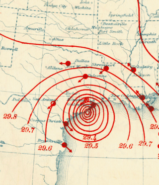
The 1900 Galveston hurricane, also known as the Great Galveston hurricane and the Galveston Flood, and known regionally as the Great Storm of 1900 or the 1900 Storm, is the deadliest natural disaster in United States history. The strongest storm of the 1900 Atlantic hurricane season, it left between 6,000 and 12,000 fatalities in the United States; the number most cited in official reports is 8,000. Most of these deaths occurred in and near Galveston, Texas, after the storm surge inundated the coastline and the island city with 8 to 12 ft of water. It remains among the deadliest Atlantic hurricanes on record. In addition to the number killed, the storm destroyed about 7,000 buildings of all uses in Galveston, which included 3,636 demolished homes; every dwelling in the city suffered some degree of damage. The hurricane left approximately 10,000 people in the city homeless, out of a total population of fewer than 38,000. The disaster ended the Golden Era of Galveston, as the hurricane alarmed potential investors, who turned to Houston instead. In response to the storm, three engineers designed and oversaw plans to raise the Gulf of Mexico shoreline of Galveston Island by 17 ft (5.2 m) and erect a 10 mi (16 km) seawall.

<span class="mw-page-title-main">2008 Atlantic hurricane season</span> Hurricane season in the Atlantic Ocean

The 2008 Atlantic hurricane season was the most destructive Atlantic hurricane season since 2005, causing over 1,000 deaths and nearly $50 billion in damage. The season ranked as the third costliest ever at the time, but has since fallen to ninth costliest. It was an above-average season, featuring sixteen named storms, eight of which became hurricanes, and five which further became major hurricanes. It officially started on June 1 and ended on November 30. These dates conventionally delimit the period of each year when most tropical cyclones form in the Atlantic basin. However, the formation of Tropical Storm Arthur caused the season to start one day early. It was the only year on record in which a major hurricane existed in every month from July through November in the North Atlantic. Bertha became the longest-lived July tropical cyclone on record for the basin, the first of several long-lived systems during 2008.

<span class="mw-page-title-main">Hurricane Rita</span> Category 5 Atlantic hurricane in 2005

Hurricane Rita was the most intense tropical cyclone on record in the Gulf of Mexico and the fourth-most intense Atlantic hurricane ever recorded. Part of the record-breaking 2005 Atlantic hurricane season, which included three of the top ten most intense Atlantic hurricanes in terms of barometric pressure ever recorded, Rita was the seventeenth named storm, tenth hurricane, and fifth major hurricane of the 2005 season. It was also the earliest-forming 17th named storm in the Atlantic until Tropical Storm Rene in 2020. Rita formed near The Bahamas from a tropical wave on September 18, 2005 that originally developed off the coast of West Africa. It moved westward, and after passing through the Florida Straits, Rita entered an environment of abnormally warm waters. Moving west-northwest, it rapidly intensified to reach peak winds of 180 mph (285 km/h), achieving Category 5 status on September 21. However, it weakened to a Category 3 hurricane before making landfall in Johnson's Bayou, Louisiana, between Sabine Pass, Texas and Holly Beach, Louisiana, with winds of 115 mph (185 km/h). Rapidly weakening over land, Rita degenerated into a large low-pressure area over the lower Mississippi Valley by September 26th.

<span class="mw-page-title-main">Hurricane Bret</span> Category 4 Atlantic hurricane in 1999

Hurricane Bret was the first of five Category 4 hurricanes that developed during the 1999 Atlantic hurricane season and the first tropical cyclone since Hurricane Jerry in 1989 to make landfall in Texas at hurricane intensity. Forming from a tropical wave on August 18, Bret slowly organized within weak steering currents in the Bay of Campeche. By August 20, the storm began to track northward and underwent rapid intensification on August 21. After this period of strengthening, Bret attained its peak intensity with winds of 145 miles per hour (233 km/h) and a barometric pressure of 944 mbar (hPa; 27.9 inHg). Later that day, the storm weakened to a Category 3 hurricane and made landfall on Padre Island, Texas. Shortly thereafter, the storm weakened further, becoming a tropical depression 24 hours after moving inland. The remnants of the storm eventually dissipated early on August 26 over northern Mexico.

<span class="mw-page-title-main">Hurricane Claudette (2003)</span> Category 1 Atlantic hurricane

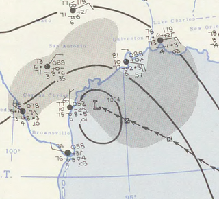
Hurricane Claudette was a moderately strong tropical cyclone that struck South Texas in July 2003. A fairly long-lived July Atlantic hurricane, Claudette was the fourth depression, third tropical storm and first hurricane of the 2003 Atlantic hurricane season. Claudette began as a tropical wave in the eastern Caribbean. It moved quickly westward, brushing past the Yucatán Peninsula before moving northwestward through the Gulf of Mexico. Claudette remained a tropical storm until just before making landfall in Port O'Connor, Texas, when it quickly strengthened to a strong Category 1 hurricane on the Saffir-Simpson Hurricane Scale. Forecasting of its path and intensity was uncertain throughout its lifetime, resulting in widespread and often unnecessary preparations along its path.

<span class="mw-page-title-main">Hurricane Ella (1958)</span> Category 2 Atlantic hurricane in 1958

Hurricane Ella brought flooding to the Greater Antilles and Texas in September 1958. The fifth named storm and third hurricane of the annual season, Ella developed from a tropical wave located just east of the Lesser Antilles on August 30. Initially a tropical depression, it strengthened into Tropical Storm Ella six hours later. The system crossed the Leeward Islands and entered the Caribbean Sea late on August 30. Ella headed westward and by August 31, intensified into a Category 1 hurricane. Hours later, it strengthened into a Category 2 hurricane on the Saffir–Simpson hurricane wind scale. The storm curved northwestward while south of Hispaniola and as a result, struck the Tiburon Peninsula of Haiti on September 1. Flooding in that country killed 30 people in Aux Cayes and left 3 other missing. Additionally, thousands were left homeless, about one-third of crops were washed out, and numerous cattle were killed.

<span class="mw-page-title-main">Hurricane Jerry (1989)</span> Category 1 Atlantic Hurricane in 1989

Hurricane Jerry caused minor damage in Texas and flash flooding in Kentucky and Virginia in October 1989. The fourteenth tropical cyclone, tenth named storm, and seventh hurricane of the season, Jerry developed from a tropical wave in the Bay of Campeche on October 12. Initially a tropical depression, the system moved north-northwestward across the Gulf of Mexico and strengthened into Tropical Storm Jerry early on the following day. Jerry continuously deepened until October 14 and then maintained intensity while curving northeastward and briefly decelerating. Later that day, the storm re-curved north-northwestward. Jerry began to intensify on October 15 and soon became a Category 1 hurricane on the Saffir–Simpson hurricane wind scale. Early on October 16, Jerry made landfall on Galveston Island, Texas with winds of 85 miles per hour (137 km/h). Less than six hours later, Jerry weakened to a tropical storm and then a tropical depression shortly thereafter. Late on October 16, Jerry was absorbed by a frontal system while situated over southwestern Arkansas.

<span class="mw-page-title-main">1915 Galveston hurricane</span> Category 4 Atlantic hurricane

The 1915 Galveston hurricane was a tropical cyclone that caused extensive damage in the Galveston area in August 1915. Widespread damage was also documented throughout its path across the Caribbean Sea and the interior of the United States. Due to similarities in strength and trajectory, the storm drew comparisons with the deadly 1900 Galveston hurricane. While the newly completed Galveston Seawall mitigated a similar-scale disaster for Galveston, numerous fatalities occurred along unprotected stretches of the Texas coast due to the storm's 16.2 ft (4.9 m) storm surge. Overall, the major hurricane inflicted at least $30 million in damage and killed 403–405 people. A demographic normalization of landfalling storms suggested that an equivalent storm in 2005 would cause $68.0 billion in damage in the United States.

<span class="mw-page-title-main">Hurricane Fern</span> Category 1 Atlantic hurricane in 1971

Hurricane Fern was the sixth named storm and fourth hurricane of the 1971 Atlantic hurricane season. It formed from a tropical wave which interacted with a large trough of low pressure to form Fern, as well as Hurricane Ginger, Tropical Storm Heidi, and a system later designated as Tropical Depression Sixteen, which moved into South Carolina. Fern crossed southeastern Louisiana as a tropical depression on September 4 before swinging back out over the Gulf of Mexico. Fern reached hurricane status on September 8, reaching a peak intensity of 90 mph (140 km/h) before making landfall near Freeport, Texas, two days later.

<span class="mw-page-title-main">Tropical Storm Cindy (1963)</span> Atlantic tropical storm in 1963

Tropical Storm Cindy was a strong tropical storm which impacted portions of the United States Gulf Coast in September 1963. The third named storm of the 1963 Atlantic hurricane season, Cindy developed within a trough as a tropical storm in the Gulf of Mexico on 16 September. The disturbance quickly intensified, with a distinct eye becoming visible on satellite imagery as it drifted north-northwestwards toward the Texas coastline. After peaking with 1-minute maximum sustained winds of 65 mph (100 km/h), it made landfall at High Island on the morning of 17 September at peak strength with an atmospheric pressure of 997 mbar. Cindy remained nearly stationary for almost a day, dropping copious rainfall over the Texas coastal plain, before finally turning west-southwestward and dissipating west of Corpus Christi on 20 September.

<span class="mw-page-title-main">Hurricane Dolly (2008)</span> Category 2 Atlantic hurricane in 2008

Hurricane Dolly was a strong tropical cyclone that made landfall in Deep South Texas in July 2008. Dolly was the fourth tropical cyclone and second hurricane to form during the 2008 Atlantic hurricane season. Dolly developed on July 20 from an area of disturbed weather in association with a strong tropical wave. It was named at the same time it formed, as the precursor wave already had tropical storm-force winds. This marked the earliest time a fourth named cyclone formed since the 2005 season, which used to hold the record until it was surpassed by the 2012 season, the 2016 season, and the 2020 season.

<span class="mw-page-title-main">Effects of Tropical Storm Allison in Texas</span> Aftermath of tropical storm in texas

The effects of Tropical Storm Allison in Texas included 23 deaths caused by extreme flooding. The first storm of the 2001 Atlantic hurricane season, Tropical Storm Allison lasted unusually long for a June storm, remaining tropical or subtropical for 15 days. The storm developed from a tropical wave in the northern Gulf of Mexico on June 4, and struck the Texas coast shortly thereafter. It drifted northward through the state, turned back to the south, and re-entered the Gulf of Mexico. The storm continued to the east-northeast, made landfall on Louisiana, then moved across the southeast United States and Mid-Atlantic. Allison was the first storm since Tropical Storm Frances in 1998 to strike the northern Texas coastline.

<span class="mw-page-title-main">Effects of Hurricane Ike in Texas</span>

The effects of Hurricane Ike in Texas were crippling and long-lasting. Ike's effects included deaths, widespread damage, and impacts to the price and availability of oil and gas. Hurricane Ike also had a long-term impact on the U.S. economy. Making landfall over Galveston, at 2:10 a.m. CDT on September 13, 2008, Category 2 Hurricane Ike caused extensive damage in Texas, with sustained winds of 110 mph (180 km/h), a 22 ft (6.7 m) storm surge, and widespread coastal flooding.

<span class="mw-page-title-main">1941 Texas hurricane</span> Category 3 Atlantic hurricane in 1941

The 1941 Texas hurricane, the second storm of the 1941 Atlantic hurricane season, was a large and intense tropical cyclone that struck coastal Texas as a major hurricane in September 1941, causing relatively severe damage. The storm is estimated to have formed in the eastern Gulf of Mexico on September 16. After attaining hurricane strength, it completed a clockwise loop and turned northwestward. The hurricane continued to strengthen until it made landfall near East Matagorda Bay, Texas, with winds of 125 miles per hour (201 km/h), but rapidly weakened as it headed inland. Damage from the storm amounted to about $6.5 million, and crops throughout the region were largely destroyed. The city of Houston suffered extensive damage as the storm passed to the east. The hurricane disrupted activities related to the Louisiana Maneuvers. Later, the system became extratropical and passed over Lake Huron, killing three people in Toronto. Overall, seven people lost their lives due to the cyclone.

<span class="mw-page-title-main">Hurricane Harvey</span> Category 4 Atlantic hurricane in 2017

Hurricane Harvey was a devastating Category 4 hurricane that made landfall on Texas and Louisiana in August 2017, causing catastrophic flooding and more than 100 deaths. It is tied with 2005's Hurricane Katrina as the costliest tropical cyclone on record, inflicting $125 billion in damage, primarily from catastrophic rainfall-triggered flooding in the Houston metropolitan area and Southeast Texas; this made the storm the costliest natural disaster recorded in Texas at the time. It was the first major hurricane to make landfall in the United States since Wilma in 2005, ending a record 12-year span in which no hurricanes made landfall at the intensity of a major hurricane throughout the country. In a four-day period, many areas received more than 40 inches (1,000 mm) of rain as the system slowly meandered over eastern Texas and adjacent waters, causing unprecedented flooding. With peak accumulations of 60.58 in (1,539 mm), in Nederland, Texas, Harvey was the wettest tropical cyclone on record in the United States. The resulting floods inundated hundreds of thousands of homes, which displaced more than 30,000 people and prompted more than 17,000 rescues.

References

General
Specific
  1. 1 2 3 4 5 6 7 8 9 10 11 12 13 14 15 16 17 18 19 20 21 22 23 24 Berg, Robbie; National Hurricane Center (March 18, 2014). Hurricane Ike: November 5 - 9, 2008 (PDF) (Tropical Cyclone Report). United States National Oceanic and Atmospheric Administration's National Weather Service. Retrieved June 30, 2016.
  2. 1 2 3 "Hurricane Ike kills 7 in Cuba". USA Today. Associated Press. September 12, 2008. Retrieved September 12, 2008.
  3. "Evacuation and Devastation in Southern Texas". Boston.com. September 14, 2009. Retrieved November 24, 2013.
  4. "Flooding in Miss. and FL". Usatoday.com. September 11, 2008. Retrieved November 24, 2013.
  5. Costliest U.S. tropical cyclones tables updated (PDF) (Report). National Hurricane Center. January 26, 2018. Retrieved January 26, 2018.
  6. "Texas goes on 'largest search-and-rescue operation' after Ike". NewsOK. Associated Press. September 14, 2008. Retrieved October 23, 2018.
  7. Berg, p. 1
  8. Knabb, Richard; National Hurricane Center (August 28, 2008). "Atlantic Tropical Weather Outlook for 8:00 AM EDT on August 28, 2008". Miami, Florida: United States National Oceanic and Atmospheric Administration's National Weather Service. Retrieved July 18, 2014.
  9. Brown, Daniel; National Hurricane Center (August 29, 2008). "Atlantic Tropical Weather Outlook for 8:00 PM EDT on August 29, 2008". Miami, Florida: United States National Oceanic and Atmospheric Administration's National Weather Service. Retrieved July 18, 2014.
  10. 1 2 3 4 5 6 Berg, p. 2
  11. Avila, Lixion; National Hurricane Center (September 1, 2008). "Tropical Depression Nine Discussion Number 1". Miami, Florida: United States National Oceanic and Atmospheric Administration's National Weather Service. Retrieved July 18, 2014.
  12. Roberts, Dave; Franklin, James; National Hurricane Center (September 1, 2008). "Tropical Storm Ike Discussion Number 3". Miami, Florida: United States National Oceanic and Atmospheric Administration's National Weather Service. Retrieved July 18, 2014.
  13. Pasch, Richard; Franklin, James; National Hurricane Center (September 2, 2008). "Tropical Storm Ike Discussion Number 4". Miami, Florida: United States National Oceanic and Atmospheric Administration's National Weather Service. Retrieved July 18, 2014.
  14. 1 2 Knabb, Richard; National Hurricane Center (September 3, 2008). "Hurricane Ike Discussion Number 10". Miami, Florida: United States National Oceanic and Atmospheric Administration's National Weather Service. Retrieved July 18, 2014.
  15. Brown, Daniel; National Hurricane Center (September 3, 2008). "Hurricane Ike Special Discussion Number 11". Miami, Florida: United States National Oceanic and Atmospheric Administration's National Weather Service. Retrieved July 18, 2014.
  16. Blake, Eric; National Hurricane Center (September 4, 2008). "Hurricane Ike Special Discussion Number 11". Miami, Florida: United States National Oceanic and Atmospheric Administration's National Weather Service. Retrieved July 18, 2014.
  17. Rhome, Jamie; Beven, Jack; National Hurricane Center (September 6, 2008). "Hurricane Ike Advisory 22". Miami, Florida: United States National Oceanic and Atmospheric Administration's National Weather Service. Retrieved July 18, 2014.
  18. 1 2 3 4 5 6 7 8 Berg, p. 3
  19. Rhome, Jamie; Beven, Jack; National Hurricane Center (September 7, 2008). "Hurricane Ike Discussion 27". Miami, Florida: United States National Oceanic and Atmospheric Administration's National Weather Service. Retrieved July 18, 2014.
  20. Rhome, Jamie; Avila, Lixion; National Hurricane Center (September 8, 2008). "Hurricane Ike Discussion 30". Miami, Florida: United States National Oceanic and Atmospheric Administration's National Weather Service. Retrieved July 18, 2014.
  21. Rhome, Jamie; Avila, Lixion; National Hurricane Center (September 8, 2008). "Hurricane Ike Discussion 31". Miami, Florida: United States National Oceanic and Atmospheric Administration's National Weather Service. Retrieved July 18, 2014.
  22. Knabb, Richard; National Hurricane Center (September 10, 2008). "Hurricane Ike Discussion 40". Miami, Florida: United States National Oceanic and Atmospheric Administration's National Weather Service. Retrieved July 18, 2014.
  23. 1 2 Berg, p. 16
  24. Berg, p. 4
  25. British Red Cross (September 7, 2008). "Red Cross responds to Hurricane Ike". ReliefWeb. Retrieved July 19, 2014.
  26. 1 2 3 4 Pan American Health Organization; World Health Organization (September 8, 2008). "Hurricane Ike in Turks and Caicos: Appeal for health emergency needs". ReliefWeb. Retrieved October 23, 2018.
  27. "Powerful Hurricane Ike looms as trouble for Gulf". Associated Press. September 7, 2008. Archived from the original on September 10, 2008. Retrieved September 7, 2008.
  28. "Texas Water/Wastewater Agency Response Network". www.txwarn.org.
  29. Association, American Water Works. "Water/Wastewater Agency Response Network - American Water Works Association". www.nationalwarn.org.
  30. "More relief moves into Louisiana as other states brace for more storms". National Rural Water Association. 2008. Archived from the original on February 26, 2012. Retrieved September 5, 2008.
  31. "States prepare for second hit while providing aid to Louisiana". National Rural Water Association. 2008. Archived from the original on January 2, 2011. Retrieved September 5, 2008.
  32. "Texas Rural Water prepares for Hurricane Ike". National Rural Water Association. 2008. Archived from the original on January 2, 2011. Retrieved September 5, 2008.
  33. "Texas prepares, Louisiana systems still without power". National Rural Water Association. 2008. Archived from the original on January 2, 2011. Retrieved September 10, 2008.
  34. "Ike Turns Northeast, Threat to SA, Corpus Christi Lessened". WOAI (AM). 2008. Archived from the original on May 25, 2012. Retrieved September 11, 2008.
  35. Galveston, part of Houston evacuated ahead of Ike. Retrieved September 11, 2008.
  36. Rappleye, Christine (September 11, 2008). "Mandatory evacuation called for Jefferson, Orange counties". Hearst Newspapers II, LLC . Retrieved January 12, 2015.
  37. Carney, Mike. "Hurricane Ike: Bush declares emergency in Texas". USA Today. Archived from the original on September 11, 2008. Retrieved September 12, 2008.
  38. Cutter, Susan L.; Smith, Mark M. (2009). "Fleeing from the Hurricane's Wrath. Evacuation and the Two Americas". Environment. 51 (2): 26–36. doi:10.3200/envt.51.2.26-36. S2CID   154800836.
  39. "Hurricane Local Statement for IKE". Houston/Galveston, Texas National Weather Service Forecast Office. 2008.
  40. "'Certain death' warning over Ike". BBC News. September 12, 2008. Retrieved September 18, 2008.
  41. 1 2 3 4 Ahlers, Mike; et al. (September 12, 2008). "One death as Ike edges toward Category 3 power". CNN. Archived from the original on September 18, 2008. Retrieved September 13, 2008.
  42. A Million Flee as Huge Storm Hits Texas Coast, September 13, 2008.
  43. "Experts: Giant Ike's Size Driving Massive Storm Surge". Fox News. Associated Press. September 12, 2008. Retrieved September 11, 2008.
  44. "Oil prices churn as Hurricane Ike approaches". CNN Money. Archived from the original on September 17, 2008. Retrieved September 12, 2008.
  45. "Turks & Caicos Weekly News". Tcweeklynews.com. Retrieved November 24, 2013.
  46. "Hurricane Ike strikes Turks and Caicos as Category 4". USA Today. Associated Press. September 11, 2008. Retrieved June 30, 2016.
  47. Oughton, Sarah (September 7, 2008). "Red Cross responds to Hurricane Ike". British Red Cross. Archived from the original on September 7, 2008. Retrieved September 7, 2008.
  48. Weaver, Matthew (September 7, 2008). "Hurricane Ike hampers relief effort in Haiti". The Guardian. Retrieved June 30, 2016.
  49. "Ike's floods kill 48, cut off aid to parts of Haiti". CNN. Associated Press. September 7, 2008. Archived from the original on September 11, 2008. Retrieved September 7, 2008.
  50. 1 2 'One million homeless' in Haiti BBC News
  51. "Raúl Castro cifra los daños del huracán Irma a Cuba en 13.185 millones de dólares" (in Spanish). Agencia EFE. December 22, 2017. Retrieved May 20, 2019.
  52. 1 2 Brown, Daniel P; Beven, John L; Franklin, James L; Blake, Eric S (May 1, 2010). "Atlantic Hurricane Season of 2008*". Monthly Weather Review. American Meteorological Society. 138 (5): 1975–2001. Bibcode:2010MWRv..138.1975B. doi:10.1175/2009MWR3174.1. Archived (PDF) from the original on October 12, 2012. Retrieved December 9, 2012.
  53. "Hurricane Matthew in Cuba causes over 2.5 bln USD in damage". CubaSi. Xinhua. November 1, 2016. Archived from the original on October 12, 2019. Retrieved November 3, 2016.
  54. Pielke, Roger A; Rubiera, Jose; Landsea, Christopher; Fernández, Mario L; Klein, Roberta (August 1, 2003). "Hurricane Vulnerability in Latin America and The Caribbean: Normalized Damage and Loss Potentials" (PDF). Natural Hazards Review. 4 (3): 101–114. doi:10.1061/(ASCE)1527-6988(2003)4:3(101). ISSN   1527-6988. Archived from the original (PDF) on August 15, 2014. Retrieved November 28, 2012.
  55. Blake, Eric S; Kimberlain, Todd B; Berg, Robert J; Cangialosi, John P; Beven II, John L; National Hurricane Center (February 12, 2013). Hurricane Sandy: October 22 – 29, 2012 (PDF) (Tropical Cyclone Report). United States National Oceanic and Atmospheric Administration's National Weather Service. Archived from the original on February 17, 2013. Retrieved February 17, 2013.
  56. "Lluvias intensas observadas y grandes inundaciones reportadas" [Heavy rains observed and large reported floods] (in Spanish). Instituto Nacional de Recursos Hidráulicos. 2003. Archived from the original on March 12, 2007. Retrieved February 10, 2007.
  57. 1 2 RA IV Hurricane Committee (August 12, 2005). Twenty-seventh Session (March 31 to April 5, 2005) (PDF) (Final Report). World Meteorological Organization. Archived from the original on November 27, 2012. Retrieved November 27, 2012.
  58. "Hurricane Wilma exacts losses of 704 million dollars: Cuban government". ReliefWeb. November 28, 2005. Retrieved May 8, 2010.
  59. Associated Press (September 10, 2008). "Lesson From Ike: Cuba gets evacuations right". NBC News. Retrieved October 23, 2018.
  60. Deadly hurricane heads for Havana BBC News
  61. "Cuban storms damage 'worst ever'". BBC. September 16, 2008. Retrieved September 16, 2008.
  62. "Report on 2008 Hurricane Season in Cuba". World Meteorological Organization . Retrieved April 14, 2009.
  63. Costliest U.S. tropical cyclones tables update (PDF) (Report). United States National Hurricane Center. January 12, 2018. Archived (PDF) from the original on January 27, 2018. Retrieved January 12, 2018.
  64. "Assessing the U.S. Climate in 2018". National Centers for Environmental Information (NCEI). February 6, 2019. Retrieved February 9, 2019.
  65. Ailworth, Erin (September 13, 2008). "Gas, heating oil prices rise on hurricane threat". Boston Globe. Retrieved September 13, 2008.
  66. Neal, Dale (September 21, 2008). "State's Highest Gas Prices? They're in WNC". Asheville Citizen-Times.
  67. Ostendorff, Jon (September 26, 2008). "Fuel Shortage Worsened by Timing of Hurricanes". Asheville Citizen-Times.
  68. Kovach, Gretel C. (September 12, 2008). "Crew Trapped on Disabled Ship in Ike's Wake". Newsweek. Retrieved September 13, 2008.
  69. Flood, Mary; Mellon, Ericka (September 12, 2008). "Coast Guard aborts rescue mission of stranded freighter". Houston Chronicle. Retrieved September 13, 2008.
  70. "Adrift bulk freighter survives hurricane, awaits tow to port". United States Coast Guard. September 13, 2008. Archived from the original on September 15, 2008. Retrieved September 13, 2008.
  71. Deslatte, Melinda; McGill, Kevin (September 12, 2008). "Louisiana coast floods as Ike heads west". KATC. Archived from the original on September 13, 2008. Retrieved September 12, 2008.
  72. "Ike causes new round of power outages". Times-Picayune . September 13, 2008. Archived from the original on September 15, 2008. Retrieved September 15, 2008.
  73. "Most of Louisiana's Coast Still Flooded by Ike". KALB-TV. Associated Press. September 14, 2008. Archived from the original on September 23, 2015. Retrieved September 15, 2008.
  74. Search and Rescue Operations Coordinated by LDWF Transport 363 Residents to Safety During Hurricane Ike's Pass Through State, September 16, 2008 Emergency.louisiana.gov Archived August 1, 2020, at the Wayback Machine
  75. "Louisiana La. resident drowns in Ike's floodwaters". KPLC. Associated Press. September 13, 2008. Retrieved September 13, 2008.[ permanent dead link ]
  76. 1 2 "Louisiana coast floods as Ike heads west". KATC. Associated Press. September 14, 2008. Archived from the original on November 16, 2018. Retrieved September 15, 2008.
  77. "2 Ike evacuees die in traffic crash". KATC. Associated Press. September 13, 2008. Archived from the original on November 16, 2018. Retrieved September 13, 2008.
  78. 1 2 3 4 Juan A. Lozano & Chris Duncan, Associated Press Writers (September 13, 2008). "Ike blasts Texas coast, floods homes, cuts power". Yahoo! NEWS. Archived from the original on September 16, 2008. Retrieved September 13, 2008.
  79. "Hurricane Ike Situation Report # 2" (PDF). September 14, 2008. Archived from the original (PDF) on October 1, 2008. Retrieved September 19, 2008.
  80. Sullivan, Brian K.; Korosec, Tom (September 13, 2008). "Hurricane Ike Batters Texas, 4.5 Million Lose Power (Update4)". Bloomberg. Retrieved September 19, 2008.
  81. Wray, James; Stabe, Ulf (September 17, 2008). "Houston struggles back to normal after Hurricane Ike (Feature)". Monsters and Critics. Archived from the original on May 27, 2009. Retrieved May 5, 2009.
  82. 1 2 Carney, Mike; Dorell, Oren (September 12, 2008). "Hurricane Ike: Galveston says 25% ignored evacuation order". USA Today. Archived from the original on September 15, 2008. Retrieved September 12, 2008.
  83. Casselman, Ben (September 12, 2008). "As Waters Rise, Many Decline To Leave Galveston Island". The Wall Street Journal. Retrieved September 13, 2008.
  84. Ortolon, Ken. "Rising From the Storm: UTMB struggles to recover after Hurricane Ike" (PDF). Texas Medicine. No. December 2009. Retrieved June 30, 2016.
  85. Press Room Archived January 3, 2009, at the Wayback Machine
  86. Crystal Beach looks like 'someone set a bomb off' Archived September 17, 2008, at the Wayback Machine Galveston County 06:06 am CDT on Monday, September 15, 2008 KHOU.com
  87. Drye, Willie. ""Freak" Hurricane Ike Will Cost $22 Billion". National Geographic. Archived from the original on September 16, 2008. Retrieved June 30, 2016.
  88. Rappleye, Christine (September 19, 2008). "Bridge City residents try to dry out, clean up". Beaumontenterprise.com. Retrieved November 24, 2013.
  89. KHOU.com staff report (September 13, 2008). "Minor damage at NASA's Johnson Space Center". KHOU-TV. Archived from the original on September 18, 2008. Retrieved September 13, 2008.
  90. "Hurricane remnants blamed for 3 deaths in". Kansas City Star . Associated Press. September 14, 2008.
  91. 1 2 News Staff (September 14, 2008). ""A significant amount of time" to restore power, LG&E says". Courier-Journal .
  92. Noll, Jessica (September 14, 2008). "Beshear Issues State Of Emergency For Ky". WCPO. Archived from the original on November 16, 2017. Retrieved September 14, 2008.
  93. "National Weather Service Forecast Office – Wilmington Ohio". Erh.noaa.gov. Retrieved November 24, 2013.
  94. "State Of Emergency In Ohio, 1.4 Million Without Power". WHIO.com. WHIO. September 15, 2008.{{cite web}}: Missing or empty |url= (help)
  95. Wartenberg, Steve (October 7, 2008). "Damage in Ohio from Hurricane Ike at $553 million and counting". The Columbus Dispatch. Retrieved June 30, 2016.
  96. Martin, Betsey (September 14, 2008). "5:34 pm Update — Power Outages Reported Statewide". KARK. Archived from the original on October 11, 2008. Retrieved September 14, 2008.
  97. Ellis, Amber; Wartman, Scott (September 14, 2008). "High winds knock out power". Cincinnati Enquirer . Retrieved September 15, 2008.
  98. Staff Reports (September 18, 2008). "More DP&L customers get power; about 90,000 still in dark". Dayton Daily News.
  99. "1 dead from Ike when tree falls on mobile home". greeleytribune.com. Associated Press. September 14, 2008. Archived from the original on July 18, 2011. Retrieved September 15, 2008.
  100. "Thousands Still Without Power in Illinois". WTHI-TV. Associated Press. September 15, 2008. Retrieved September 15, 2008.[ permanent dead link ]
  101. Staff Writer (September 14, 2008). "Remnants of Ike Leave Thousands Without Power in Missouri". St. Louis American . Retrieved September 15, 2008.[ permanent dead link ]
  102. News Staff (September 14, 2008). "Ike's Strong Winds, Power Outages Plague Pittsburgh Area". WTAE-TV. Archived from the original on February 14, 2012. Retrieved September 15, 2008.
  103. Staff Report (September 15, 2008). "Thousands still without power; winds blamed for Kentucky boy's death". Evansville Courier & Press . Retrieved September 15, 2008.
  104. Staff Report (September 15, 2008). "Power Trouble Lingers After Ike Strikes Indiana". WRTV. Archived from the original on September 29, 2008. Retrieved September 15, 2008.
  105. "Heavy winds lead to power outages". WCAX. September 15, 2008. Archived from the original on September 25, 2008. Retrieved September 15, 2008.
  106. Canwest Media (September 15, 2008). "Windsor storm topples trees". Windsor Star . Archived from the original on March 3, 2016. Retrieved July 1, 2016.
  107. Canwest Media (September 15, 2008). "Ike's fury keeps 25,000 Ontarians in the dark". Ottawa Citizen. Archived from the original on March 3, 2016. Retrieved July 1, 2016.
  108. 1 2 3 CRIACC and Environment Canada (September 25, 2008). "Remnants of Tropical Storm "Ike" – September 14–15, 2008". Centre des Ressources en Impacts et Adaptations au Climat et à ses Chamgements (CRIACC). Archived from the original on February 26, 2009. Retrieved October 4, 2008.
  109. Staff Journalist (September 15, 2008). "Fortes pluies sur Québec" (in French). Radio-Canada (Quebec City). Archived from the original on January 13, 2009. Retrieved October 4, 2008.
  110. Staff Journalist (September 16, 2008). "Métro breakdowns blamed on humidity". Montreal Gazette . Retrieved July 1, 2016.[ permanent dead link ]
  111. 1 2 Staff Journalist (September 16, 2008). "L'Océan coule à pic" (in French). Radio-Canada (Est du Quebec). Archived from the original on September 19, 2008. Retrieved July 1, 2016.
  112. "Gas prices skyrocket again as Ike touches down". Canwest News Service. September 13, 2008. Archived from the original on May 18, 2012. Retrieved September 28, 2008.
  113. Staff Writer (September 17, 2008). "Fierce Storm Hits Southwest Iceland". Iceland Review. Archived from the original on June 5, 2011. Retrieved June 4, 2009.
  114. Staff Writer (September 18, 2008). "Ex-Hurricane Ike makes landfall in Northern Europe". European Organisation for the Exploitation of Meteorological Satellites. Archived from the original on November 15, 2008. Retrieved June 4, 2009.
  115. Wettre, C. (October 7, 2008). "Dust Storm off Iceland". NASA. Retrieved June 4, 2009.
  116. Caribbean Disaster Emergency Response Agency (September 7, 2008). "Update on Impacts on CDERA Participating States Aug 23 – Sep 7, 2008". ReliefWeb. Retrieved July 19, 2014.
  117. "FEMA 'insensitive' toward Ike victims, Texas officials say | Houston & Texas News | Chron.com — Houston Chronicle". Houston Chronicle. October 27, 2008. Retrieved July 4, 2010.
  118. Fernandez, Manny (October 11, 2011). "In Texas, Extending the Miseries of Hurricane Ike". The New York Times. Retrieved October 23, 2018.
  119. 1 2 3 4 Federal Emergency Management Agency. 2008. "Social Environment." pp 4–11 in Hurricane Ike Impact Report. Retrieved October 21, 2012. (fema.gov)
  120. Ruggiero, KJ, Gros K, McCauley JL, Resnick HS, Morgan M, Kilpatrick DG, Muzzy W, Acierno R. 2012 "Mental health outcomes among adults in Galveston and Chambers counties after Hurricane Ike." Disaster Med Public Health Prep. (1):26–32 Retrieved November 20, 2012
  121. 1 2 3 Norris, Fran H.2010 "Prevalence and Consequences of Disaster-Related Illness." American Psychological Association 55(3)Pp:221–230. Retrieved October 21, 2012.
  122. 1 2 Centers for Disease Control and Prevention. 2009. Carbon Monoxide Exposures After Hurricane Ike. Retrieved November 19, 2012.
  123. 1 2 Smith, L; Maus, E; Fife, C; McCarthy, J; Koehler, M; Hawkins, T; Hampson, N (2009). "[Abstract] Dying to play video games: Carbon monoxide poisoning from electrical generators following Hurricane Ike". Undersea and Hyperbaric Medicine. Archived from the original on December 30, 2013. Retrieved December 30, 2013.{{cite journal}}: CS1 maint: unfit URL (link)
  124. Texas Department of State Health Services. 2008. Health-Related Precautions Following Hurricane Ike. Archived October 23, 2014, at the Wayback Machine
  125. Jayson Stark (2008). Carlos Zambrano threw a no-hitter during that series.Strange But True year in review. Retrieved on February 1, 2009.
  126. Associated Press (2008). Air Force runs down clock to stop Houston rally. Retrieved on February 1, 2009.
  127. Associated Press (2008). Arkansas-Texas postponed due to Hurricane Ike. Retrieved on February 1, 2009.
  128. "WrestleMania XXV ticket sales postponed to Nov. 8". World Wrestling Entertainment. September 19, 2008. Retrieved September 28, 2008.
  129. "Tickets for the 25th Anniversary of WrestleMania available now!". World Wrestling Entertainment. November 8, 2008. Archived from the original on February 18, 2009. Retrieved November 8, 2008.
  130. StormJunkie (August 3, 2008). "Why I Am Voting for Ike Relief". Weather Underground. Archived from the original on December 2, 2013. Retrieved November 24, 2013.
  131. Masters, Jeff (October 2, 2008). "October hurricane season outlook". Weather Underground. Archived from the original on July 15, 2014. Retrieved November 24, 2013.
  132. Masters, Jeff (October 29, 2008). "Honduras, Yemen struggle to recover from tropical cyclones; tropics remain quiet". Weather Underground. Archived from the original on December 2, 2013. Retrieved November 24, 2013.
  133. "USA: Additional medical aid set for arrival at clinics, shelters Tuesday". ReliefWeb Mobile. September 13, 2008. Retrieved August 29, 2019.[ verification needed ]
  134. Hecht, Jon (August 26, 2017). "7 Organizations You Can Donate To Right Now To Help Hurricane Harvey Victims". Bustle. Retrieved August 29, 2019.[ verification needed ]
  135. "Hurricane Ike". U.S. Energy Information Administration. United States Department of Energy. September 2008. Archived from the original on October 23, 2018. Retrieved October 23, 2018.
  136. Cappiello, Dina; Bass, Frank; Burdeau, Cain (October 5, 2008). "AP Investigation: Ike environmental toll apparent". Yahoo News. Associated Press. Archived from the original on October 9, 2008. Retrieved October 16, 2008.
  137. Rice, Harvey (March 6, 2009). "Oil tanker rights itself after taking on water off Galveston". Houston Chronicle. Archived from the original on April 18, 2023.
  138. Turner, Allan (March 11, 2009). "Tanker's double hull prevented major spill off Galveston". Houston Chronicle. Archived from the original on April 18, 2023.
  139. "Environmental damage widespread after Ike". NBC News. Associated Press. October 5, 2008. Archived from the original on April 18, 2023.
  140. "Retired Hurricane Names Since 1954". National Oceanic and Atmospheric Administration. April 22, 2009. Archived from the original on June 28, 2011. Retrieved April 22, 2009.
  141. Casselman, Ben (June 4, 2009). "Planning the 'Ike Dike' Defense" . Wall Street Journal. Archived from the original on April 12, 2023.