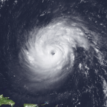
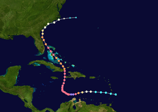
Hurricane Erika was the strongest and longest-lasting tropical cyclone in the 1997 Atlantic hurricane season. It developed from a tropical wave on September 3 and moved west-northwestward across the tropical Atlantic Ocean, steadily intensifying until it attained hurricane status on September 4, becoming the fifth named storm and third hurricane of the season. Erika passed a short distance to the north of the Lesser Antilles, and later turned to the north in response to an approaching trough. The hurricane quickly strengthened to become the only major hurricane of the season, reaching maximum sustained winds of 125 mph (201 km/h) on September 8; after maintaining its peak strength for 24 hours, Erika began to weaken as it passed over cooler waters. It turned to the east, weakened to a tropical storm, and became extratropical after passing near the Azores archipelago.

Hurricane Gordon was the first tropical cyclone since 1992 to affect the Azores while retaining tropical characteristics. The eighth tropical storm, third hurricane, and first major hurricane of the 2006 Atlantic hurricane season, Gordon formed on September 10 in the tropical Atlantic Ocean. It gradually matured into a hurricane as it tracked northward, reaching its peak intensity with winds of 195 km/h (121 mph) early on September 14 while located about 925 km (575 mi) southeast of Bermuda. After becoming nearly stationary, Gordon weakened to minimal hurricane status, although it re-intensified after accelerating to the east. It weakened again after moving over cooler waters, and passed through the Azores on September 20. Shortly thereafter, it became an extratropical cyclone and subsequently affected Spain, Ireland, and the United Kingdom.

Hurricane Wilma was the most intense tropical cyclone in the Atlantic basin on record in terms of minimum barometric pressure, with an atmospheric pressure of 882 millibars (26.0 inHg). Wilma's destructive journey began in the second week of October 2005. A large area of disturbed weather developed across much of the Caribbean and gradually organized to the southeast of Jamaica. By late on October 15, the system was sufficiently organized for the National Hurricane Center to designate it as Tropical Depression Twenty-Four.

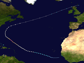
The meteorological history of Hurricane Ivan, the longest tracked tropical cyclone of the 2004 Atlantic hurricane season, lasted from late August through late September. The hurricane developed from a tropical wave that moved off the coast of Africa on August 31. Tracking westward due to a ridge, favorable conditions allowed it to develop into Tropical Depression Nine on September 2 in the deep tropical Atlantic Ocean. The cyclone gradually intensified until September 5, when it underwent rapid deepening and reached Category 4 status on the Saffir-Simpson Hurricane Scale; at the time Ivan was the southernmost major North Atlantic hurricane on record.

Hurricane Isaac was a large and powerful tropical cyclone that lasted through late September and early October 2000. The thirteenth tropical cyclone, ninth named storm, and the fifth hurricane of 2000 Atlantic hurricane season, Isaac developed from a tropical wave south of Cape Verde on September 21. The depression intensified, and on the following day, it was upgraded to Tropical Storm Isaac. Due to conductive atmospheric conditions, Isaac continued to strengthen, and attained hurricane intensity on September 23. Isaac managed to become a Category 3 hurricane on September 24, before steadily weakening shortly thereafter. By September 26, the storm had deteriorated to a Category 1 hurricane. However, it again encountered favorable conditions, which caused Isaac to re-intensify.

Hurricane Bertha was the longest-lived Atlantic tropical cyclone on record during July, as well as the furthest east system to attain tropical storm intensity during the month. The second named storm, first hurricane, and first major hurricane of the active 2008 season, Bertha developed into a tropical depression on July 3 from a tropical wave that departed western Africa two days prior. On a west-northwest to northwest track, the depression intensified into Tropical Storm Bertha six hours formation and ultimately attained hurricane intensity on July 7. A period of rapid deepening brought the cyclone to its peak as a Category 3 hurricane with winds of 125 mph (205 km/h) late that afternoon. Changes in wind shear and the storm's internal structure allowed Bertha to fluctuate in intensity over the next week as it passed very near Bermuda, but a track over cooler waters eventually caused the system to become an extratropical cyclone by July 20. It continued northeast and was absorbed by another low near Iceland the following day. Rough surf propelled by Bertha killed three people along the East Coast of the United States; hundreds of other swimmers were injured and/or required rescuing. In Bermuda, some streets were flooded and strong gusts cut power to approximately 7,500 homes; only minor damage was observed.
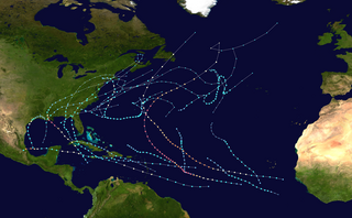
The 2011 Atlantic hurricane season was the second in a group of three very active Atlantic hurricane seasons, each with 19 named storms, tied with 1887, 1995, 2010, and 2012. The above-average activity was mostly due to a La Niña that persisted during the previous year. Of the season's 19 tropical storms, only seven strengthened into hurricanes, and four of those became major hurricanes: Irene, Katia, Ophelia, and Rina. The season officially began on June 1 and ended on November 30, dates which conventionally delimit the period during each year in which most tropical cyclones develop in the Atlantic Ocean. However, the first tropical storm of the season, Arlene, did not develop until nearly a month later. The final system, Tropical Storm Sean, dissipated over the open Atlantic on November 11.
The 2011 Atlantic hurricane season was an event in the annual hurricane season in the north Atlantic Ocean. It was well above average, with 19 tropical storms forming. Even so, it was the first season on record in which the first eight storms failed to attain hurricane strength. The season officially began on June 1, 2011, and ended on November 30, 2011, dates that conventionally delimit the period of each year when most tropical cyclones develop in the Atlantic basin. The season's first storm, Tropical Storm Arlene did not form until June 28. The final storm to develop, Tropical Storm Sean, dissipated on November 11.

The 2016 Atlantic hurricane season was the first above-average hurricane season since 2012, producing 15 named storms, 7 hurricanes and 4 major hurricanes. The season officially started on June 1 and ended on November 30, though the first storm, Hurricane Alex which formed in the Northeastern Atlantic, developed on January 12, being the first hurricane to develop in January since 1938. The final storm, Otto, crossed into the Eastern Pacific on November 25, a few days before the official end. Following Alex, Tropical Storm Bonnie brought flooding to South Carolina and portions of North Carolina. Tropical Storm Colin in early June brought minor flooding and wind damage to parts of the Southeastern United States, especially Florida. Hurricane Earl left 94 fatalities in the Dominican Republic and Mexico, 81 of which occurred in the latter. In early September, Hurricane Hermine, the first hurricane to make landfall in Florida since Hurricane Wilma in 2005, brought extensive coastal flooding damage especially to the Forgotten and Nature coasts of Florida. Hermine was responsible for five fatalities and about $550 million (2016 USD) in damage.

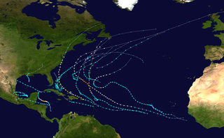
The 2017 Atlantic hurricane season was a devastating and extremely active Atlantic hurricane season that became the costliest on record, with a damage total of at least $294.92 billion (USD). The season featured 17 named storms, 10 hurricanes, and 6 major hurricanes. Most of the season's damage was due to hurricanes Harvey, Irma, and Maria. Another notable hurricane, Nate, was the worst natural disaster in Costa Rican history. These four storm names were retired following the season due to the number of deaths and amount of damage they caused. Collectively, the tropical cyclones were responsible for at least 3,364 deaths. The season also had the highest accumulated cyclone energy (ACE) since 2005 with an approximate index of 224 units, with a record three hurricanes each generating an ACE of over 40: Irma, Jose, and Maria. This season featured two Category 5 hurricanes, and the only season other than 2007 with two hurricanes making landfall at that intensity. The season's ten hurricanes occurred one after the other, the greatest number of consecutive hurricanes in the satellite era, and tied for the highest number of consecutive hurricanes ever observed in the Atlantic basin.
Hurricane Matthew was the first Category 5 Atlantic hurricane since Felix in 2007 and the southernmost Category 5 Atlantic hurricane on record. The system originated from a tropical wave that emerged off the west coast of Africa on September 22, and ultimately dissipated as an extratropical cyclone near Atlantic Canada on October 10. Late on September 29, it began a period of explosive intensification that brought it to Category 5 strength early on October 1. It weakened slightly and remained a Category 4 until its landfalls in Haiti and Cuba, afterwards it traversed through the Bahamas and paralleled the coast of Florida until making landfall in South Carolina as a Category 1 hurricane. Matthew later transitioned into a post-tropical cyclone on October 10.

Hurricane Ophelia was regarded as the worst storm to affect Ireland in 50 years, and was also the easternmost Atlantic major hurricane on record. The tenth and final consecutive hurricane and the sixth major hurricane of the very active 2017 Atlantic hurricane season, Ophelia had non-tropical origins from a decaying cold front on 6 October. Located within a favorable environment, the storm steadily strengthened over the next two days, drifting north and then southeastwards before becoming a hurricane on 11 October. After becoming a Category 2 hurricane and fluctuating in intensity for a day, Ophelia intensified into a major hurricane on 14 October south of the Azores, brushing the archipelago with high winds and heavy rainfall. Shortly after achieving peak intensity, Ophelia began weakening as it accelerated over progressively colder waters to its northeast towards Ireland and Great Britain. Completing an extratropical transition early on 16 October, Ophelia became the second storm of the 2017–18 European windstorm season. Early on 17 October, the cyclone crossed the North Sea and struck western Norway, with wind gusts up to 70 kilometres per hour (43 mph) in Rogaland county, before weakening during the evening of 17 October. The system then moved across Scandinavia, before dissipating over Norway on the next day.

Hurricane Katia was a strong tropical cyclone which became the most intense storm to hit the Bay of Campeche since Karl in 2010. The eleventh named storm and sixth hurricane of the exceptionally active 2017 Atlantic hurricane season, Katia originated on September 5, out of a broad low-pressure area that formed in the Bay of Campeche. Located in an area of weak steering currents, Katia meandered around in the region, eventually intensifying into a hurricane on September 6. The nascent storm eventually peaked as a 105 mph (165 km/h) Category 2 hurricane on the Saffir–Simpson scale while it began to move southwestward. However, land interaction began to weaken the hurricane as it approached the Gulf Coast of Mexico. Early on September 9, Katia made landfall near Tecolutla at minimal hurricane intensity. The storm quickly dissipated several hours later, although its mid-level circulation remained intact and later spawned what would become Hurricane Otis in the Eastern Pacific.

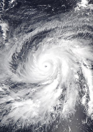
Hurricane Maria was among the most intense Atlantic hurricanes on record and caused catastrophic damage in Puerto Rico in late September 2017. Originating from a tropical wave, it developed into a tropical depression on September 16 while situated to the east of the Lesser Antilles. Gradual intensification occurred over the next day or two and it strengthened into a tropical storm, which was named Maria. By late on September 17, Maria had intensified into a hurricane. As it approached the island arc, it underwent explosive intensification on September 18, with the hurricane reaching Category 5 intensity as it made landfall on the island of Dominica early on September 19. Land interaction weakened the storm somewhat, although it was able to quickly recover and later peaked that night with sustained winds of 175 mph (280 km/h) and a pressure of 908 mbar (26.8 inHg). Early the next morning it weakened to a high-end Category 4 hurricane before making landfall in Puerto Rico. Maria weakened significantly due to crossing the island, but was able to strengthen somewhat as it passed close to Hispaniola and The Bahamas on September 21–23. Structural changes in the hurricane as it moved further north and close to the Outer Banks in the United States ultimately caused Maria to weaken quickly. Turning away from the United States as a weakened tropical storm, it became extratropical on September 30, dissipating 3 days later.
The 2021 Atlantic hurricane season was the third-most active Atlantic hurricane season on record in terms of number of tropical cyclones, although many of them were weak and short-lived. With 21 named storms forming, it became the second season in a row and third overall in which the designated 21-name list of storm names was exhausted. Seven of those storms strengthened into a hurricane, four of which reached major hurricane intensity, which is slightly above-average. The season officially began on June 1 and ended on November 30. These dates historically describe the period in each year when most Atlantic tropical cyclones form. However, subtropical or tropical cyclogenesis is possible at any time of the year, as demonstrated by the development of Tropical Storm Ana on May 22, making this the seventh consecutive year in which a storm developed outside of the official season.
Hurricane Walaka was a strong tropical cyclone that brought high surf and a powerful storm surge to the Northwestern Hawaiian Islands. Walaka was the nineteenth named storm, twelfth hurricane, eighth major hurricane, and second Category 5 hurricane of the 2018 Pacific hurricane season.
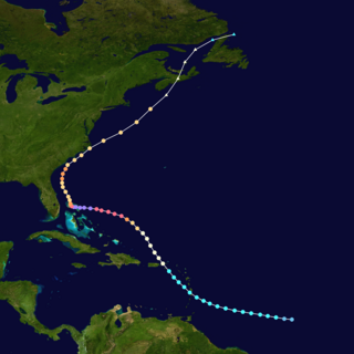
Hurricane Dorian was the strongest hurricane to affect The Bahamas on record, causing catastrophic damage on the islands of Abaco Islands and Grand Bahama, in early September 2019. The cyclone's intensity, as well as its slow forward motion near The Bahamas, broke numerous records. The fifth tropical cyclone, fourth named storm, second hurricane, and first major hurricane of the 2019 Atlantic hurricane season, Dorian originated from a westward-traveling tropical wave, that departed from the western coast of Africa on August 19. The system organized into a tropical depression and later a tropical storm, both on August 24.

Hurricane Epsilon was a strong tropical cyclone that affected Bermuda, and parts of North America and Western Europe. The twenty-seventh tropical or subtropical cyclone, twenty-sixth named storm, eleventh hurricane, and fourth major hurricane of the extremely-active 2020 Atlantic hurricane season, Epsilon had a non-tropical origin, developing from an upper-level low off the East Coast of the United States on October 13. The low gradually organized, becoming Tropical Depression Twenty-Seven on October 19, and six hours later, Tropical Storm Epsilon. The storm executed a counterclockwise loop before turning westward, while strengthening. On October 20, Epsilon began undergoing rapid intensification, becoming a Category 1 hurricane on the next day, before peaking as a Category 3 major hurricane on October 22, with maximum 1-minute sustained winds of 115 mph (185 km/h) and a minimum central pressure of 952 millibars (28.1 inHg). This made Epsilon the easternmost major hurricane this late in the calendar year, as well as the strongest late-season major hurricane in the northeastern Atlantic, and the fastest recorded case of a tropical cyclone undergoing rapid intensification that far northeast that late in the hurricane season. Afterward, Epsilon began to weaken as the system turned northward, with the storm dropping to Category 1 intensity late that day. Epsilon maintained its intensity as it moved northward, passing to the east of Bermuda. On October 24, Epsilon turned northeastward and gradually accelerated, before weakening into a tropical storm on the next day. On October 26, Epsilon transitioned into an extratropical cyclone, before being absorbed by another larger extratropical storm later that same day.

Hurricane Pablo was a late-season tropical cyclone that became the farthest east-forming hurricane in the North Atlantic tropical cyclone basin on record, beating the previous record set by Hurricane Vince in 2005. The seventeenth tropical/subtropical cyclone, sixteenth named storm and sixth hurricane of the 2019 Atlantic hurricane season, Pablo originated from a baroclinic cyclone a few hundred miles west of the Azores Islands. The precursor cyclone formed on October 22, traveling eastward towards the island chain. The system initially had multiple centers of circulation, but they consolidated into one small low-pressure system embedded within the larger extratropical storm. On October 25, the embedded cyclone developed into a subtropical cyclone, receiving the name Pablo. The cyclone continued eastwards, transitioning into a fully-tropical storm later that day. Pablo quickly intensified between October 26 and 27, forming an eye and spiral rainbands. At 12:00 Coordinated Universal Time (UTC) on October 27, Pablo intensified into a Category 1 hurricane. The storm continued to strengthen, reaching its peak intensity of 80 mph (130 km/h) and a minimum central pressure of 977 mbar (28.9 inHg) at 18:00 UTC on the same day. The storm quickly weakened the next day, becoming extratropical again, and dissipated on October 29.

Hurricane Sam was a powerful and long-lived tropical cyclone that threatened Bermuda, lasting from September 22 through October 7, 2021. It was the fifth longest-lasting intense Atlantic hurricane, as measured by accumulated cyclone energy, since reliable records began in 1966. Sam was the eighteenth named storm, seventh hurricane, and fourth major hurricane of the 2021 Atlantic hurricane season.