Ridge

Last updated
A mountain ridge in Japan Tsubakurodake from Otenshodake 2002-8-22.jpg
A mountain ridge in Japan
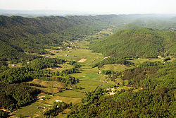
A strike ridge within the Appalachian Mountains. Bristol tenn ridgelines2.jpg
A strike ridge within the Appalachian Mountains.
The edges of tuyas can form ridges. The Table1.jpg
The edges of tuyas can form ridges.
Pirin Mountain main ridge - view from Koncheto knife-edge ridge towards the pyramidal peaks Vihren and Kutelo Vihren Pirin IMG 0859.jpg
Pirin Mountain main ridge – view from Koncheto knife-edge ridge towards the pyramidal peaks Vihren and Kutelo

A ridge is a long, narrow, elevated geomorphologic landform, structural feature, or a combination of both separated from the surrounding terrain by steep sides. The sides of a ridge slope away from a narrow top, the crest or ridgecrest, with the terrain dropping down on either side. The crest, if narrow, is also called a ridgeline. Limitations on the dimensions of a ridge are lacking. Its height above the surrounding terrain can vary from less than a meter to hundreds of meters. A ridge can be either depositional, erosional, tectonic, or a combination of these in origin and can consist of either bedrock, loose sediment, lava, or ice depending on its origin. A ridge can occur as either an isolated, independent feature or part of a larger geomorphological and/or structural feature. Frequently, a ridge can be further subdivided into smaller geomorphic or structural elements. [1] [2] [3]
Contents

Classification

As in the case of landforms in general, there is a lack of any commonly agreed classification or typology of ridges. They can be defined and classified on the basis of a variety of factors including either genesis, morphology, composition, statistical analysis of remote sensing data, or some combinations of these factors.

An example of ridge classification is that of Schoeneberger and Wysocki, [4] which provides a relatively simple and straightforward system that is used by the USA National Cooperative Soil Survey Program to classify ridges and other landforms. This system uses the dominant geomorphic process or setting to classify different groups of landforms into two major groups, Geomorphic Environments and Other Groupings with a total of 16 subgroups. The groups and their subgroups are not mutually exclusive; landforms, including ridges, can belong to multiple subgroups. In this classification, ridges are found in the Aeolian, Coastal Marine and Estuarine, Lacustrine, Glacial, Volcanic and Hydrothermal, Tectonic and Structural, Slope, and Erosional subgroups. [4]

Aeolian ridge

Aeolian dune ridge
An aeolian dune ridge is a ridge of sand piled up by the wind. A sand dune can be either a hill or ridge of sand piled up by the wind. A single sand dune can range in length from less than one meter to several tens of kilometers, their height can vary from a few tens of centimeters to a 150 meters. Megadunes or draas are very large dunes, which can have smaller dunes superimposed on them. [5]

Coastal ridges

Beach ridge
A beach ridge is a low, essentially continuous ridge of beach or beach-and-dune sediments piled up by the action of waves and currents on a shoreline beyond the present limit of storm waves and the reach of ordinary tides. They occur occurring singly or as one of a series of approximately parallel ridges that are roughly parallel to the shoreline. [2]

Erosional ridges

Dendritic ridge
In typical dissected plateau terrain, the stream drainage valleys will leave intervening ridges. These are by far the most common ridges. These ridges usually represent slightly more erosion resistant rock, but not always – they often remain because there were more joints where the valleys formed or other chance occurrences. This type of ridge is generally somewhat random in orientation, often changing direction frequently, often with knobs at intervals on the ridge top.
Strike ridge
A strike ridge is an asymmetric ridge created by the differential erosion of a hard, erosion-resistant, dipping layer of rock sandwiched between layers of weaker, more easily eroded rock. A strike ridge has a distinctly gentler sloping side (dip slope), that roughly parallels the inclined layer of erosion-resistant rock. The opposite side of a strike ridge is relatively short, steep or cliff-like slope (scarp slope) that cuts across the tilted layers of rocks. In foldbelts such as the Ridge-and-Valley Appalachians, they form series of long, parallel, straight to arcuate ridges. Strike ridges are subdivided into cuestas, flatirons, homoclinal ridges, and hogbacks. [2]
Reef
A term applied by early explorers and settlers in the western United States to ridges that formed a rocky barrier to land travel, by analogy with ocean reefs as barriers to sea travel. Examples include Capitol Reef National Park [6] and the San Rafael Reef. The usage may have originated with sailors during the Australian gold rushes to describe the gold-bearing ridges of Bendigo, Australia. [7]

Glacial ridges

Moraines and eskers
Glacial activity may leave ridges in the form of moraines and eskers. An arête is a thin ridge of rock that is formed by glacial erosion. [2]
Pressure ridge (ice)
An ice pressure ridge is a ridge of deformed ice along the boundaries of individual ice floes when the ice floes on a lake or ocean collide and compress their edges. The average height of a sea ice pressure ridge is between 5 and 30 meters. [8]

Tectonic and Structural ridges

Oceanic spreading ridge
In tectonic spreading zones around the world, such as at the Mid-Atlantic Ridge, the volcanic activity forms new land between tectonic boundaries creating volcanic ridges at the spreading zone. Isostatic settling and erosion gradually reduces the elevations moving away from the zone. [2]
Impact Crater ridge
Large asteroid strikes typically form large impact craters bordered by rim(s) that are circular ridge(s). [9]
Shutter ridge
A shutter ridge is a ridge that has moved along a fault line, blocking or diverting drainage. Typically, a shutter ridge creates a valley corresponding to the alignment of the fault that produces it. [2]

Volcanic and Hydrothermal ridges

Pressure ridge (lava)
A specific case of pressure ridge, also known as a tumulus, usually develops in lava flows, especially when slow-moving lava beneath a solidified crust wells upward. The brittle crust usually buckles to accommodate the inflating core of the flow, thus creating a central crack along the length of the tumulus. [10]
Volcanic crater/caldera ridges
Large volcanoes often have a central crater or caldera or both, bordered by rims that form circular ridges. [10]
Volcanic subglacial ridges
Subglacial volcanic eruptions can create volcanic ridges, known as tindars , that vary from tens of meters up to 250 meters in height. Tindars are a piles of volcanic ash that have been generated by explosive subaqueous eruptions in a glacial meltwater-filled vault or lake within a glacier or ice sheet. [11]

See also

Related Research Articles

<span class="mw-page-title-main">Geomorphology</span> Scientific study of landforms

Geomorphology is the scientific study of the origin and evolution of topographic and bathymetric features created by physical, chemical or biological processes operating at or near Earth's surface. Geomorphologists seek to understand why landscapes look the way they do, to understand landform and terrain history and dynamics and to predict changes through a combination of field observations, physical experiments and numerical modeling. Geomorphologists work within disciplines such as physical geography, geology, geodesy, engineering geology, archaeology, climatology, and geotechnical engineering. This broad base of interests contributes to many research styles and interests within the field.

<span class="mw-page-title-main">Shoal</span> Natural submerged sandbank that rises from a body of water to near the surface

In oceanography, geomorphology, and geoscience, a shoal is a natural submerged ridge, bank, or bar that consists of, or is covered by, sand or other unconsolidated material and rises from the bed of a body of water to near the surface. It often refers to those submerged ridges, banks, or bars that rise near enough to the surface of a body of water as to constitute a danger to navigation. Shoals are also known as sandbanks, sandbars, or gravelbars. Two or more shoals that are either separated by shared troughs or interconnected by past or present sedimentary and hydrographic processes are referred to as a shoal complex.

Landforms are categorized by characteristic physical attributes such as their creating process, shape, elevation, slope, orientation, rock exposure, and soil type.

<span class="mw-page-title-main">Aeolian processes</span> Processes due to wind activity

Aeolian processes, also spelled eolian, pertain to wind activity in the study of geology and weather and specifically to the wind's ability to shape the surface of the Earth. Winds may erode, transport, and deposit materials and are effective agents in regions with sparse vegetation, a lack of soil moisture and a large supply of unconsolidated sediments. Although water is a much more powerful eroding force than wind, aeolian processes are important in arid environments such as deserts.

<span class="mw-page-title-main">Cirque</span> An amphitheatre-like valley formed by glacial erosion

A cirque is an amphitheatre-like valley formed by glacial erosion. Alternative names for this landform are corrie and cwm. A cirque may also be a similarly shaped landform arising from fluvial erosion.

<span class="mw-page-title-main">Geology of Venus</span> Geological structure and composition of the second planet from the Sun

Venus is a planet with striking geology. Of all the other planets in the Solar System, it is the one nearest to Earth and most like it in terms of mass, but has no magnetic field or recognizable plate tectonic system. Much of the ground surface is exposed volcanic bedrock, some with thin and patchy layers of soil covering, in marked contrast with Earth, the Moon, and Mars. Some impact craters are present, but Venus is similar to Earth in that there are fewer craters than on the other rocky planets that are largely covered by them. This is due in part to the thickness of the Venusian atmosphere disrupting small impactors before they strike the ground, but the paucity of large craters may be due to volcanic re-surfacing, possibly of a catastrophic nature. Volcanism appears to be the dominant agent of geological change on Venus. Some of the volcanic landforms appear to be unique to the planet. There are shield and composite volcanoes similar to those found on Earth. Given that Venus has approximately the same size, density, and composition as Earth, it is plausible that volcanism may be continuing on the planet today, as demonstrated by recent studies.

<span class="mw-page-title-main">Depression (geology)</span> Landform sunken or depressed below the surrounding area

In geology, a depression is a landform sunken or depressed below the surrounding area. Depressions form by various mechanisms.

<span class="mw-page-title-main">Terrace (geology)</span> A step-like landform

In geology, a terrace is a step-like landform. A terrace consists of a flat or gently sloping geomorphic surface, called a tread, that is typically bounded on one side by a steeper ascending slope, which is called a "riser" or "scarp". The tread and the steeper descending slope together constitute the terrace. Terraces can also consist of a tread bounded on all sides by a descending riser or scarp. A narrow terrace is often called a bench.

<span class="mw-page-title-main">Terra Sabaea</span> Terra on Mars

Terra Sabaea is a large area on Mars. Its coordinates are 2°N42°E and it covers 4,700 kilometres (2,900 mi) at its broadest extent. It was named in 1979 after a classic albedo feature on the planet. Terra Sabaea is fairly large and parts of it are found in five quadrangles: Arabia quadrangle, Syrtis Major quadrangle, Iapygia quadrangle, Ismenius Lacus quadrangle, and Sinus Sabaeus quadrangle.

<span class="mw-page-title-main">Athabasca Valles</span> Outflow channel on Mars

The Athabasca Valles are a late Amazonian-period outflow channel system in the central Elysium Planitia region of Mars, located to the south of the Elysium Rise. They are part of a network of outflow channels in this region that are understood to emanate from large fissures in the Martian surface rather than the chaos terrains that source the circum-Chryse outflow channels. The Athabasca Valles in particular emanate from one of the Cerberus Fossae fissures and flow downstream to the southwest, constrained to the south by a wrinkle ridge for over 100 km, before debouching into the Cerberus Palus volcanic plain. The Athabasca Valles are widely understood to be the youngest outflow channel system on the planet.

Aeolian landforms are features produced by either the erosive or depositive action of the wind. These features may be built up from sand or snow, or eroded into rock, snow, or ice. Aeolian landforms are commonly observed in sandy deserts and on frozen lakes or sea ice and have been observed and studied across Earth and on other planets, including Mars and Pluto

<span class="mw-page-title-main">Lava cave</span> Cave formed in volcanic rock, especially one formed via volcanic processes

A lava cave is any cave formed in volcanic rock, though it typically means caves formed by volcanic processes, which are more properly termed volcanic caves. Sea caves, and other sorts of erosional and crevice caves, may be formed in volcanic rocks, but through non-volcanic processes and usually long after the volcanic rock was emplaced.

<span class="mw-page-title-main">Noachis quadrangle</span> Map of Mars

The Noachis quadrangle is one of a series of 30 quadrangle maps of Mars used by the United States Geological Survey (USGS) Astrogeology Research Program. The Noachis quadrangle is also referred to as MC-27.

<span class="mw-page-title-main">Phlegra Montes</span> System of eroded massifs and knobbly terrain on Mars

The Phlegra Montes are a system of eroded Hesperian–Noachian-aged massifs and knobby terrain in the mid-latitudes of the northern lowlands of Mars, extending northwards from the Elysium Rise towards Vastitas Borealis for nearly 1,400 km (870 mi). The mountain ranges separate the large plains provinces of Utopia Planitia (west) and Amazonis Planitia (east), and were named in the 1970s after a classical albedo feature. The massif terrains are flanked by numerous parallel wrinkle ridges known as the Phlegra Dorsa.

<span class="mw-page-title-main">Ganges Mensa</span> Mensa in the Coprates quadrangle of Mars

Ganges Mensa is a mesa and an interior layered deposit in Ganges Chasma, one of the peripheral valleys of Valles Marineris on Mars. The mesa rises up to 4 kilometres (13,000 ft) from the floor of Ganges Chasma, nearly to the same elevation as the surrounding plateaux of Lunae Planum. Like Hebes Mensa, the mesa is completely separated from the surrounding canyon walls and has sustained significant erosion that has caused it to retreat in areal extent.

<span class="mw-page-title-main">Mount Cayley volcanic field</span> Remote volcanic zone in Canada

The Mount Cayley volcanic field (MCVF) is a remote volcanic zone on the South Coast of British Columbia, Canada, stretching 31 km (19 mi) from the Pemberton Icefield to the Squamish River. It forms a segment of the Garibaldi Volcanic Belt, the Canadian portion of the Cascade Volcanic Arc, which extends from Northern California to southwestern British Columbia. Most of the MCVF volcanoes were formed during periods of volcanism under sheets of glacial ice throughout the last glacial period. These subglacial eruptions formed steep, flat-topped volcanoes and subglacial lava domes, most of which have been entirely exposed by deglaciation. However, at least two volcanoes predate the last glacial period and both are highly eroded. The field gets its name from Mount Cayley, a volcanic peak located at the southern end of the Powder Mountain Icefield. This icefield covers much of the central portion of the volcanic field and is one of the several glacial fields in the Pacific Ranges of the Coast Mountains.

The common surface features of Mars include dark slope streaks, dust devil tracks, sand dunes, Medusae Fossae Formation, fretted terrain, layers, gullies, glaciers, scalloped topography, chaos terrain, possible ancient rivers, pedestal craters, brain terrain, and ring mold craters.

<span class="mw-page-title-main">Surface features of Venus</span>

The surface of Venus is dominated by geologic features that include volcanoes, large impact craters, and aeolian erosion and sedimentation landforms. Venus has a topography reflecting its single, strong crustal plate, with a unimodal elevation distribution that preserves geologic structures for long periods of time. Studies of the Venusian surface are based on imaging, radar, and altimetry data collected from several exploratory space probes, particularly Magellan, since 1961. Despite its similarities to Earth in size, mass, density, and possibly composition, Venus has a unique geology that is unlike Earth's. Although much older than Earth's, the surface of Venus is relatively young compared to other terrestrial planets, possibly due to a global-scale resurfacing event that buried much of the previous rock record. Venus is believed to have approximately the same bulk elemental composition as Earth, due to the physical similarities, but the exact composition is unknown. The surface conditions on Venus are more extreme than on Earth, with temperatures ranging from 453 to 473 °C and pressures of 95 bar. Venus lacks water, which makes crustal rock stronger and helps preserve surface features. The features observed provide evidence for the geological processes at work. Twenty feature types have been categorized thus far. These classes include local features, such as craters, coronae, and undae, as well as regional-scale features, such as planitiae, plana, and tesserae.

Azas Plateau is a volcanic field in Russia. It is also known as East Tuva Plateau, Khamsara-Biykhem Plateau and Northeast Tuva Plateau. It covers a surface area of 2,000 square kilometres (770 sq mi) west of Lake Baikal. Volcanic activity in the area also occurred at the Oka Plateau and the Jom-Bolok volcanic field.

<span class="mw-page-title-main">Geology of Reykjanes Peninsula</span>

The Reykjanes Peninsula in southwest Iceland is the continuation of the mostly submarine Reykjanes Ridge, a part of the Mid-Atlantic Ridge, on land and reaching from Esja in the north and Hengill in the east to Reykjanestá in the west. Suðurnes is an administrative unit covering part of Reykjanes Peninsula.

References

  1. Nystuen, J.P. (ed.). Rules and recommendations for naming geological units in Norway, Norsk Geologisk Tidsskrift 69, supplement 2. Oslo, Norway. p. 111.
  2. 1 2 3 4 5 6 Huggett, R.J. (2011). Fundamentals of geomorphology (3rd ed.). New York, New York: Routledge. p. 516. ISBN   978-0203860083.
  3. Neuendorf, K.K.E.; Mehl, J.P. Jr.; Jackson, J.A., eds. (2005). Glossary of Geology (5th ed.). Alexandria, Virginia: American Geological Institute. p. 554. ISBN   978-0922152896.
  4. 1 2 Schoeneberge, P.J.; Wysocki, D.A. (2017). "Geomorphic Description System, version 5.0" (PDF). National Soil Survey Center, Lincoln, Nebraska: USDA Natural Resources Conservation Service. pp. 25–52.
  5. Pye., K.; Tsoar., H. (2008). Sand and Sand Dunes. Berlin, Germany: Springer-Verlag. p. 458. ISBN   978-3-540-85909-3.
  6. "Capitol Reef National Park – Geology". Capitol Reef National Park web site. U.S. National Park Service. 2007. Retrieved January 17, 2009.
  7. Van Cott, John W. (1990). Utah place names : a comprehensive guide to the origins of geographic names : a compilation. Salt Lake City, Utah: University of Utah Press. p. 65. ISBN   9780874803457 . Retrieved 2 June 2022.
  8. Timco, G.W.; Burden, R.P. (1997). "An analysis of the shapes of sea ice ridges". Cold Regions Science and Technology. 25: 65–77.
  9. French, Bevan M (1998). Traces of Catastrophe: A Handbook of Shock-Metamorphic Effects in Terrestrial Meteorite Impact Structures. Houston, Texas: Lunar and Planetary Institute. p. 120. OCLC   40770730.
  10. 1 2 Schmincke, Hans-Ulrich (2003). Volcanism. Berlin, Germany: Springer. pp. 13–20. ISBN   9783540436508.
  11. Smellie, J.L. (2013). "Quaternary Vulcanism: Subglacial Landforms". In Elias, S.A.; Mock, C.J. (eds.). Encyclopedia of Quaternary Science (2nd ed.). New York, New York: Elsevier. pp. 780–802. ISBN   978-0-444-53643-3.