Related Research Articles
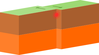
A transform boundary occurs when two tectonic plates move past one another. Shear stress operates at transform boundaries, which involves sliding motion. No lithosphere is destroyed or created, and mountain chains are not built at transform boundaries. They accommodate the lateral offset between segments of divergent boundaries, forming a zigzag pattern. This is a result of oblique seafloor spreading where the direction of motion is not perpendicular to the trend of the overall divergent boundary. A smaller number of such faults are found on land, although these are generally better-known, such as the San Andreas Fault and North Anatolian Fault.

An escarpment is a steep slope or long cliff that forms as a result of faulting or erosion and separates two relatively level areas having different elevations.

The North American Plate is a tectonic plate covering most of North America, Cuba, the Bahamas, extreme northeastern Asia, and parts of Iceland and the Azores. With an area of 76 million km2 (29 million sq mi), it is the Earth's second largest tectonic plate, behind the Pacific Plate.

The Cumberland Mountains are a mountain range in the southeastern section of the Appalachian Mountains. They are located in western Virginia, southwestern West Virginia, the eastern edges of Kentucky, and eastern middle Tennessee, including the Crab Orchard Mountains. Their highest peak, with an elevation of 4,223 feet (1,287 m) above mean sea level, is High Knob, which is located near Norton, Virginia.

A ridge is a long, narrow, elevated geomorphologic landform, structural feature, or combination of both separated from the surrounding terrain by steep sides. The sides of a ridge slope away from a narrow top, the crest or ridgecrest, with the terrain dropping down on either side. The crest, if narrow, is also called a ridgeline. Limitations on the dimensions of a ridge are lacking. Its height above the surrounding terrain can vary from less than a meter to hundreds of meters. A ridge can be either depositional, erosional, tectonic, or combination of these in origin and can consist of either bedrock, loose sediment, lava, or ice depending on its origin. A ridge can occur as either an isolated, independent feature or part of a larger geomorphological and/or structural feature. Frequently, a ridge can be further subdivided into smaller geomorphic or structural elements.

A wrinkle ridge is a type of feature commonly found on lunar maria, or basalt plains. These features are low, sinuous ridges formed on the mare surface that can extend for up to several hundred kilometers. Wrinkle ridges are tectonic features created after the lava cooled and solidified. They frequently outline ring structures buried within the mare, follow circular patterns outlining the mare, or intersect protruding peaks. They are sometimes called veins due to their resemblance to the veins that protrude from beneath the skin.

A fracture zone is a linear feature on the ocean floor—often hundreds, even thousands of kilometers long—resulting from the action of offset mid-ocean ridge axis segments. They are a consequence of plate tectonics. Lithospheric plates on either side of an active transform fault move in opposite directions; here, strike-slip activity occurs. Fracture zones extend past the transform faults, away from the ridge axis; seismically inactive, they display evidence of past transform fault activity, primarily in the different ages of the crust on opposite sides of the zone.

Wheeler Ridge is an unincorporated community in the southwestern San Joaquin Valley, within Kern County, California. It is at the junction of the valley floor and the Wheeler Ridge landform of the Tehachapi Mountains.

Sanborn County Park is a 3,453 acre county park situated in the Santa Cruz Mountains, managed by the Santa Clara County Parks and Recreation Department. The deeply forested park features over 15 miles of trails, second-growth redwoods, and creeks that flow year-round. It offers hiking, RV camping, walk-in campsites, and picnicking/BBQ sites. In the summer months, Sanborn County Park hosts the only outdoor Shakespearean company in Silicon Valley.

The state of Georgia is commonly divided into four geologic regions that influence the location of the state's five traditional physiographic regions. The four geologic regions include the Appalachian foreland, Blue Ridge, Piedmont, and Coastal Plain. These four geologic regions commonly share names with and typically overlap the four physiographic regions of the state: the Appalachian Plateau and adjacent Valley and Ridge; the Blue Ridge; the Piedmont and the Coastal Plain. The geologic regions of the state, established by geologists based on relationships between stratigraphic units, significantly influence the physiographic regional names used by physical geographers. Geologic regions of the state, however, do not perfectly coincide with physiographic regions of the state. Most geologic regions (terranes) in the state are separated from one another by major thrust faults that formed during the growth of the Appalachian Mountains. The Appalachian foreland, for example, is separated from the geologic Blue Ridge by the Talladega-Cartersville-Great Smoky fault. The geologic Blue Ridge is separated from the geologic Piedmont by the Brevard fault zone. The Fall Line, the surface expression of the Coastal Plain unconformity, is the geologic boundary between the Piedmont and the Coastal Plain.

The Explorer Ridge is a mid-ocean ridge, a divergent tectonic plate boundary located about 241 km (150 mi) west of Vancouver Island, British Columbia, Canada. It lies at the northern extremity of the Pacific spreading axis. To its east is the Explorer Plate, which together with the Juan de Fuca Plate and the Gorda Plate to its south, is what remains of the once-vast Farallon Plate which has been largely subducted under the North American Plate. The Explorer Ridge consists of one major segment, the Southern Explorer Ridge, and several smaller segments. It runs northward from the Sovanco Fracture Zone to the Queen Charlotte Triple Junction, a point where it meets the Queen Charlotte Fault and the northern Cascadia subduction zone.
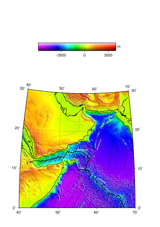
The Aden Ridge is a part of an active oblique rift system located in the Gulf of Aden, between Somalia and the Arabian Peninsula to the north. The rift system marks the divergent boundary between the Somali and Arabian tectonic plates, extending from the Owen Transform Fault in the Arabian Sea to the Afar Triple Junction or Afar Plume beneath the Gulf of Tadjoura in Djibouti.

Huo Hsing Vallis is an ancient river valley in the Syrtis Major quadrangle of Mars at 30.5° north latitude and 293.4° west longitude. It is about 318 km long and was named after the word for "Mars" in Chinese.

The Eastern Frontal Fault System is a megaregional system of oblique and thrust faults cross-cutting Colombia from Ecuador in the south to Venezuela in the north. The system from south to north covers ten out of 32 departments of Colombia; Nariño, Putumayo, Cauca, Huila, Caquetá, Cundinamarca, Meta, Boyacá, Casanare and Arauca. The Eastern Frontal Fault System underlies and affects the capitals of Putumayo, Mocoa, Caquetá, Florencia, Meta, Villavicencio and Casanare, Yopal. The fault system has a total length of 921.4 kilometres (572.5 mi) with a cumulative length of the faults of 1,821.8 kilometres (1,132.0 mi) and runs along an average northeast to southwest strike of 042.1 ± 19 bordering and crossing the Eastern Ranges of the Colombian Andes. The fault system forms the boundary between the North Andes microplate and the South American Plate.
The Rosas-Julumito Fault is an oblique dextral strike-slip fault in the department of Cauca in southwestern Colombia. The fault is part of the megaregional Romeral Fault System and has a total length of 43.3 kilometres (26.9 mi) and runs along an average northeast to southwest strike of 026.9 ± 7 in the Central Ranges of the Colombian Andes. The fault is associated with the 1983 Popayán earthquake that partially destroyed Popayán, the capital of Cauca, and led to more than 300 fatalities. A maximum moment magnitude earthquake of 6.8 is estimated for the fault.
The Espíritu Santo Fault is a dextral oblique strike-slip fault in the department of Antioquia in northwestern Colombia. The fault has a total length of 124.4 kilometres (77.3 mi) and runs along an average northeast to southwest strike of 033.9 ± 5 in the Central Ranges of the Colombian Andes. Estimated activity took place around 500 years ago.
The Palestina Fault is a regional sinistral oblique thrust fault in the departments of Antioquia, Caldas and Bolívar in central Colombia. The fault has a total length of 369.6 kilometres (229.7 mi) and runs along an average north-northeast to south-southwest strike of 017.8 ± 11 along the Central Ranges of the Colombian Andes.

The Chile Ridge, also known as the Chile Rise, is a submarine oceanic ridge formed by the divergent plate boundary between the Nazca Plate and the Antarctic Plate. It extends from the triple junction of the Nazca, Pacific, and Antarctic plates to the Southern coast of Chile. The Chile Ridge is easy to recognize on the map, as the ridge is divided into several segmented fracture zones which are perpendicular to the ridge segments, showing an orthogonal shape toward the spreading direction. The total length of the ridge segments is about 550–600 km.
References
- ↑ Glossary, Earthquake Hazards Program, USGS Archived 2014-09-29 at the Wayback Machine
- ↑ Easterbrook, Don J. (1999). Surface processes and landforms (2. ed.). Upper Saddle River, NJ: Prentice Hall. ISBN 0-13-860958-6.
| | This article about structural geology is a stub. You can help Wikipedia by expanding it. |