Orogeny is a mountain-building process that takes place at a convergent plate margin when plate motion compresses the margin. An orogenic belt or orogen develops as the compressed plate crumples and is uplifted to form one or more mountain ranges. This involves a series of geological processes collectively called orogenesis. These include both structural deformation of existing continental crust and the creation of new continental crust through volcanism. Magma rising in the orogen carries less dense material upwards while leaving more dense material behind, resulting in compositional differentiation of Earth's lithosphere. A synorogenic process or event is one that occurs during an orogeny.

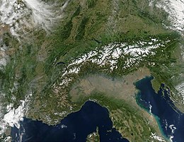
The Alps form part of a Cenozoic orogenic belt of mountain chains, called the Alpide belt, that stretches through southern Europe and Asia from the Atlantic all the way to the Himalayas. This belt of mountain chains was formed during the Alpine orogeny. A gap in these mountain chains in central Europe separates the Alps from the Carpathians to the east. Orogeny took place continuously and tectonic subsidence has produced the gaps in between.

The geology of the Appalachians dates back more than 1.1 billion years to the Mesoproterozoic era when two continental cratons collided to form the supercontinent Rodinia, 500 million years prior to the later development of the range during the formation of the supercontinent Pangea. The rocks exposed in today's Appalachian Mountains reveal elongate belts of folded and thrust faulted marine sedimentary rocks, volcanic rocks and slivers of ancient ocean floor – strong evidence that these rocks were deformed during plate collision. The birth of the Appalachian ranges marks the first of several mountain building plate collisions that culminated in the construction of the supercontinent Pangea with the Appalachians and neighboring Anti-Atlas mountains near the center. These mountain ranges likely once reached elevations similar to those of the Alps and the Rocky Mountains before they were eroded.

The Alleghanian orogeny or Appalachian orogeny is one of the geological mountain-forming events that formed the Appalachian Mountains and Allegheny Mountains. The term and spelling Alleghany orogeny was originally proposed by H.P. Woodward in 1957.
The geology of the Himalayas is a record of the most dramatic and visible creations of the immense mountain range formed by plate tectonic forces and sculpted by weathering and erosion. The Himalayas, which stretch over 2400 km between the Namcha Barwa syntaxis at the eastern end of the mountain range and the Nanga Parbat syntaxis at the western end, are the result of an ongoing orogeny — the collision of the continental crust of two tectonic plates, namely, the Indian Plate thrusting into the Eurasian Plate. The Himalaya-Tibet region supplies fresh water for more than one-fifth of the world population, and accounts for a quarter of the global sedimentary budget. Topographically, the belt has many superlatives: the highest rate of uplift, the highest relief, among the highest erosion rates at 2–12 mm/yr, the source of some of the greatest rivers and the highest concentration of glaciers outside of the polar regions. This last feature earned the Himalaya its name, originating from the Sanskrit for "the abode of the snow".

In geology, a nappe or thrust sheet is a large sheetlike body of rock that has been moved more than 2 km (1.2 mi) or 5 km (3.1 mi) above a thrust fault from its original position. Nappes form in compressional tectonic settings like continental collision zones or on the overriding plate in active subduction zones. Nappes form when a mass of rock is forced over another rock mass, typically on a low angle fault plane. The resulting structure may include large-scale recumbent folds, shearing along the fault plane, imbricate thrust stacks, fensters and klippes.

The Austroalpine nappes are a geological nappe stack in the European Alps. The Alps contain three such stacks, of which the Austroalpine nappes are structurally on top of the other two. The name Austroalpine means Southern Alpine, because these nappes crop out mainly in the Eastern Alps.

Décollement is a gliding plane between two rock masses, also known as a basal detachment fault. Décollements are a deformational structure, resulting in independent styles of deformation in the rocks above and below the fault. They are associated with both compressional settings and extensional settings.

The Western Carpathians are a mountain range and geomorphological province that forms the western part of the Carpathian Mountains.

The state of Georgia is commonly divided into four geologic regions that influence the location of the state's four traditional physiographic regions. The four geologic regions include the Appalachian foreland, Blue Ridge, Piedmont, and Coastal Plain. These four geologic regions commonly share names with and typically overlap the four physiographic regions of the state: the Appalachian Plateau and adjacent Valley and Ridge; the Blue Ridge; the Piedmont and the Coastal Plain. The geologic regions of the state, established by geologists based on relationships between stratigraphic units, significantly influence the physiographic regional names used by physical geographers. Geologic regions of the state, however, do not perfectly coincide with physiographic regions of the state. Most geologic regions (terranes) in the state are separated from one another by major thrust faults that formed during the growth of the Appalachian Mountains. The Appalachian foreland, for example, is separated from the geologic Blue Ridge by the Talladega-Cartersville-Great Smoky fault. The geologic Blue Ridge is separated from the geologic Piedmont by the Brevard fault zone. The Fall Line, the surface expression of the Coastal Plain unconformity, is the geologic boundary between the Piedmont and the Coastal Plain.

The Fatra-Tatra Area or the Tatra-Fatra Belt of core mountains is a part of the Inner Western Carpathians, a subprovince of the Western Carpathians. Most of the area lies in Slovakia with small parts reaching into Austria and Poland. The highest summit of the whole Carpathians, the Gerlachovský štít at 2,655 m (8,711 ft), lies in the High Tatras range which belongs to this area.

Fold mountains are formed by the effects of folding on layers within the upper part of the Earth's crust. Before the development of the theory of plate tectonics and before the internal architecture of thrust belts became well understood, the term was used to describe most mountain belts but has otherwise fallen out of use.

The Glarus thrust is a major thrust fault in the Alps of eastern Switzerland. Along the thrust the Helvetic nappes were thrust more than 100 km to the north over the external Aarmassif and Infrahelvetic complex. The thrust forms the contact between older (Helvetic) Permo-Triassic rock layers of the Verrucano group and younger (external) Jurassic and Cretaceous limestones and Paleogene flysch and molasse.

The Western Carpathians are an arc-shaped mountain range, the northern branch of the Alpine-Himalayan fold and thrust system called the Alpide belt, which evolved during the Alpine orogeny. In particular, their pre-Cenozoic evolution is very similar to that of the Eastern Alps, and they constitute a transition between the Eastern Alps and the Eastern Carpathians.

The Pyrenees are a 430-kilometre-long, roughly east–west striking, intracontinental mountain chain that divide France, Spain, and Andorra. The belt has an extended, polycyclic geological evolution dating back to the Precambrian. The chain's present configuration is due to the collision between the microcontinent Iberia and the southwestern promontory of the European Plate. The two continents were approaching each other since the onset of the Upper Cretaceous (Albian/Cenomanian) about 100 million years ago and were consequently colliding during the Paleogene (Eocene/Oligocene) 55 to 25 million years ago. After its uplift, the chain experienced intense erosion and isostatic readjustments. A cross-section through the chain shows an asymmetric flower-like structure with steeper dips on the French side. The Pyrenees are not solely the result of compressional forces, but also show an important sinistral shearing.

The Carpathian Flysch Belt is an arcuate tectonic zone included in the megastructural elevation of the Carpathians on the external periphery of the mountain chain. Geomorphologically it is a portion of the Outer Carpathians. Geologically it is a thin-skinned thrust belt or accretionary wedge, formed by rootless nappes consisting of so-called flysch – alternating marine deposits of claystones, shales and sandstones which were detached from their substratum and moved tens of kilometers to the north (generally). The Flysch Belt is together with Neogene volcanic complexes the only extant tectonic zone along the whole Carpathian arc.

The main points that are discussed in the geology of Iran include the study of the geological and structural units or zones; stratigraphy; magmatism and igneous rocks; ophiolite series and ultramafic rocks; and orogenic events in Iran.

The geology of Germany is heavily influenced by several phases of orogeny in the Paleozoic and the Cenozoic, by sedimentation in shelf seas and epicontinental seas and on plains in the Permian and Mesozoic as well as by the Quaternary glaciations.

The geology of Slovakia is structurally complex, with a highly varied array of mountain ranges and belts largely formed during the Paleozoic, Mesozoic and Cenozoic eras.

The geology of Italy includes mountain ranges such as the Alps and the Apennines formed from the uplift of igneous and primarily marine sedimentary rocks all formed since the Paleozoic. Some active volcanoes are located in Insular Italy.