Syncline

Last updated
A syncline is a fold of rocks with younger rock layers closer to the center of the structure, whereas an anticline is the inverse of a syncline. Anticline-Syncline-s-ink-FabioCrameri.png
A syncline is a fold of rocks with younger rock layers closer to the center of the structure, whereas an anticline is the inverse of a syncline.

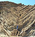
In structural geology, a syncline is a fold with younger layers closer to the center of the structure, whereas an anticline is the inverse of a syncline. A synclinorium (plural synclinoriums or synclinoria) is a large syncline with superimposed smaller folds. [1] Synclines are typically a downward fold (synform), termed a synformal syncline (i.e. a trough), but synclines that point upwards can be found when strata have been overturned and folded (an antiformal syncline).

Contents

Characteristics

On a geologic map, synclines are recognized as a sequence of rock layers, with the youngest at the fold's center or hinge and with a reverse sequence of the same rock layers on the opposite side of the hinge. If the fold pattern is circular or elongate, the structure is a basin. Folds typically form during crustal deformation as the result of compression that accompanies orogenic mountain building.

Notable examples

See also

Related Research Articles

<span class="mw-page-title-main">Los Angeles Basin</span> Sedimentary basin located along the coast of southern California

The Los Angeles Basin is a sedimentary basin located in Southern California, in a region known as the Peninsular Ranges. The basin is also connected to an anomalous group of east–west trending chains of mountains collectively known as the Transverse Ranges. The present basin is a coastal lowland area, whose floor is marked by elongate low ridges and groups of hills that is located on the edge of the Pacific plate. The Los Angeles Basin, along with the Santa Barbara Channel, the Ventura Basin, the San Fernando Valley, and the San Gabriel Basin, lies within the greater Southern California region. The majority of the jurisdictional land area of the city of Los Angeles physically lies within this basin.

<span class="mw-page-title-main">Fold (geology)</span> Stack of originally planar surfaces

In structural geology, a fold is a stack of originally planar surfaces, such as sedimentary strata, that are bent or curved ("folded") during permanent deformation. Folds in rocks vary in size from microscopic crinkles to mountain-sized folds. They occur as single isolated folds or in periodic sets. Synsedimentary folds are those formed during sedimentary deposition.

The visible geology of Hampshire in southern England broadly comprises a folded succession of sedimentary rocks dating from the Cretaceous and Palaeogene periods – mostly gentle folding in the north, more complex folding along the south coast. The lower (early) Cretaceous rocks are sandstones and mudstones whilst those of the upper (late) Cretaceous are the various formations that comprise the Chalk Group and give rise to the county's downlands. Overlying these rocks are the less consolidated Palaeogene clays, sands, gravels and silts of the Lambeth, Thames and Bracklesham Groups which characterise the Hampshire Basin.

<span class="mw-page-title-main">Sideling Hill</span> Mountain ridge in the Appalachian Mountains, U.S.

Sideling Hill, also Side Long Hill, is a long, steep, narrow mountain ridge in the Ridge-and-Valley physiographic province of the Appalachian Mountains, located in Washington County in western Maryland and adjacent West Virginia and Pennsylvania, USA. The highest point on the ridge is Fisher Point, at 2,310 feet (700 m) in Fulton County, Pennsylvania.

<span class="mw-page-title-main">Flinders Ranges</span> Mountain range in South Australia

The Flinders Ranges are the largest mountain ranges in South Australia, which starts about 200 km (125 mi) north of Adelaide. The ranges stretch for over 430 km (265 mi) from Port Pirie to Lake Callabonna.

<span class="mw-page-title-main">Anticline</span> In geology, an anticline is a type of fold that is an arch-like shape

In structural geology, an anticline is a type of fold that is an arch-like shape and has its oldest beds at its core, whereas a syncline is the inverse of an anticline. A typical anticline is convex up in which the hinge or crest is the location where the curvature is greatest, and the limbs are the sides of the fold that dip away from the hinge. Anticlines can be recognized and differentiated from antiforms by a sequence of rock layers that become progressively older toward the center of the fold. Therefore, if age relationships between various rock strata are unknown, the term antiform should be used.

<span class="mw-page-title-main">Wilpena Pound</span> Mountains north of Adelaide, South Australia

Wilpena Pound is a major natural amphitheatre of mountains located 429 kilometres (267 mi) north of Adelaide, South Australia, Australia in the heart of the Ikara-Flinders Ranges National Park. Its fringe is accessible by a sealed road between the towns of Hawker to the south and Blinman in the northern Flinders Ranges.

<span class="mw-page-title-main">Moenkopi Formation</span> Geologic formation in the southwestern United States

The Moenkopi Formation is a geological formation that is spread across the U.S. states of New Mexico, northern Arizona, Nevada, southeastern California, eastern Utah and western Colorado. This unit is considered to be a group in Arizona. Part of the Colorado Plateau and Basin and Range, this red sandstone was laid down in the Lower Triassic and possibly part of the Middle Triassic, around 240 million years ago.

<span class="mw-page-title-main">Structural basin</span> Large-scale structural geological depression formed by tectonic warping

A structural basin is a large-scale structural formation of rock strata formed by tectonic warping (folding) of previously flat-lying strata into a syncline fold. They are geological depressions, the inverse of domes. Elongated structural basins are a type of geological trough. Some structural basins are sedimentary basins, aggregations of sediment that filled up a depression or accumulated in an area; others were formed by tectonic events long after the sedimentary layers were deposited.

<span class="mw-page-title-main">Moab Fault</span> Extensional fault near Moab, Utah (USA)

The Moab Fault, near Moab, Utah, United States, is an extensional fault that runs approximately NW-SE, passing to the west of the Arches National Park. It is about 45 km (28 mi) long and has a maximum displacement of about 960 m (3,150 ft). The fault connects with the Tenmile graben in the north and extends through the Moab-Spanish Valley to the south. The fault outcrop has a well-defined fault zone bordered by a damage zone of minor faults and fractures.

<span class="mw-page-title-main">Rainbow Basin</span> Geological formation in the Calico Peaks range, Mojave Desert, San Bernardino County, California

Rainbow Basin is a geological formation in the Calico Peaks range, located approximately 8 miles (13 km) north of Barstow in the Mojave Desert in San Bernardino County, California.

<span class="mw-page-title-main">Barstow Formation</span> Geologic formation in the Mojave Desert near Barstow, San Bernardino County, California

The Barstow Formation is a series of limestones, conglomerates, sandstones, siltstones and shales exposed in the Mojave Desert near Barstow in San Bernardino County, California.

<span class="mw-page-title-main">Detachment fold</span>

A detachment fold, in geology, occurs as layer parallel thrusting along a decollement develops without upward propagation of a fault; the accommodation of the strain produced by continued displacement along the underlying thrust results in the folding of the overlying rock units. As a visual aid, picture a rug on the floor. By placing your left foot on one end and pushing towards the other end of the rug, the rug slides across the floor (decollement) and folds upward. Figure 1, is a generalized representation of the geometry assumed by a detachment fault.

<span class="mw-page-title-main">Tectonic evolution of the Barberton greenstone belt</span> Evolutionary history of ancient continental crust remnant located in southeastern Africa

The Barberton greenstone belt (BGB) is located in the Kapvaal craton of southeastern Africa. It characterizes one of the most well-preserved and oldest pieces of continental crust today by containing rocks in the Barberton Granite Greenstone Terrain (3.55–3.22 Ga). The BGB is a small, cusp-shaped succession of volcanic and sedimentary rocks, surrounded on all sides by granitoid plutons which range in age from >3547 to <3225 Ma. It is commonly known as the type locality of the ultramafic, extrusive volcanic rock, the komatiite. Greenstone belts are geologic regions generally composed of mafic to ultramafic volcanic sequences that have undergone metamorphism. These belts are associated with sedimentary rocks that occur within Archean and Proterozoic cratons between granitic bodies. Their name is derived from the green hue that comes from the metamorphic minerals associated with the mafic rocks. These regions are theorized to have formed at ancient oceanic spreading centers and island arcs. In simple terms, greenstone belts are described as metamorphosed volcanic belts. Being one of the few most well-preserved Archean portions of the crust, with Archean felsic volcanic rocks, the BGB is well studied. It provides present geologic evidence of Earth during the Archean (pre-3.0 Ga). Despite the BGB being a well studied area, its tectonic evolution has been the cause of much debate.

The Winchester-East Meon Anticline is one of a series of parallel east–west trending folds in the Cretaceous chalk of Hampshire. It lies at the western end of the South Downs, immediately to the north of the Hampshire Basin and south-east of Salisbury Plain.

<span class="mw-page-title-main">Middle Magdalena Valley</span>

The Middle Magdalena Valley, Middle Magdalena Basin or Middle Magdalena Valley Basin is an intermontane basin, located in north-central Colombia between the Central and Eastern Ranges of the Andes. The basin, covering an area of 34,000 square kilometres (13,000 sq mi), is situated in the departments of Santander, Boyacá, Cundinamarca and Tolima.

<span class="mw-page-title-main">3D fold evolution</span>

In geology, 3D fold evolution is the study of the full three dimensional structure of a fold as it changes in time. A fold is a common three-dimensional geological structure that is associated with strain deformation under stress. Fold evolution in three dimensions can be broadly divided into two stages, namely fold growth and fold linkage. The evolution depends on fold kinematics, Fold mechanism, as well as a reporting of the history behind folds and relationships by which fold age is understood. There are several ways to reconstruct the evolution progress of folds, notably by using depositional evidence, geomorphological evidence and balanced restoration.

<span class="mw-page-title-main">Southland Syncline</span> Geological structure in New Zealand

The Southland Syncline is a major geological structure located in the Southland Region of New Zealand's South Island. The syncline folds the Mesozoic greywackes of the Murihiku Terrane. The northern limb of the fold is steep to overturned, while the southern limb dips shallowly to the northeast. The axial plan dips to the northeast and the axis plunges to the southeast.

The geology of the Peak District National Park in England is dominated by a thick succession of faulted and folded sedimentary rocks of Carboniferous age. The Peak District is often divided into a southerly White Peak where Carboniferous Limestone outcrops and a northerly Dark Peak where the overlying succession of sandstones and mudstones dominate the landscape. The scarp and dip slope landscape which characterises the Dark Peak also extends along the eastern and western margins of the park. Although older rocks are present at depth, the oldest rocks which are to be found at the surface in the national park are dolomitic limestones of the Woo Dale Limestone Formation seen where Woo Dale enters Wye Dale east of Buxton.

The geology of the South Downs National Park in South East England comprises a gently folded succession of sedimentary rocks from the Cretaceous and early Palaeogene periods overlain in places by a range of superficial deposits from the last 2.6 million years. Whereas the South Downs are formed from the Late Cretaceous age chalk, the South Downs National Park extends into the Weald to the north of the range and thereby includes older rock strata dating from the Early Cretaceous including sandstones and mudstones. The youngest solid rocks are found on the southern fringes of the National Park in the eastern extension of the Hampshire Basin and include sand, silt and clay deposited during the Palaeocene and Eocene epochs.

References

  1. Synclinorium. (2008). In Encyclopædia Britannica. Retrieved May 03, 2008, from Encyclopædia Britannica Online: http://www.britannica.com/EBchecked/topic/578375/synclinorium
  2. Bauer, Paul W.; Williams, Michael L. (August 1989). "Stratigraphic nomenclature ol proterozoic rocks, northern New Mexico-revisions, redefinitions, and formalization" (PDF). New Mexico Geology. 11 (3): 45–52. doi:10.58799/NMG-v11n3.45 . Retrieved 15 April 2020.