A fissure is a long, narrow crack opening along the surface of Earth. The term is derived from the Latin word fissura , which means 'cleft' or 'crack'. Fissures emerge in Earth's crust, on ice sheets and glaciers, and on volcanoes.
A ground fissure, also called an earth fissure, is a long, narrow crack or linear opening in the Earth's crust. Ground fissures can form naturally, such as from tectonic faulting and earthquakes, or as a consequence of human activity, such as oil mining and groundwater pumping. [2] [3] Once formed, ground fissures can be extended and eroded by torrential rain. [4] They can be hazardous to people and livestock living on the affected surfaces and damaging to property and infrastructure, such as roads, underground pipes, canals, and dams. [2] [5] [6] [7]
In circumstances where there is the extensive withdrawal of groundwater, the earth above the water table can subside causing fissures to form at the surface. [8] [9] This typically occurs at the floor of arid valleys having rock formations and compacted soils with a high percentage of fine-grained material. [7] [5]
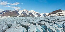
A crevasse, also called an ice fissure, is a deep linear crack in an ice sheet or glacier resulting from the opposing force produced by their movement at different rates of speed. The force builds until their associated shear stress is sufficient to break the ice along the faces. The breakage often forms vertical or near-vertical walls, which can melt and create seracs, arches, and other ice formations. [10] A crevasse may be as deep as 45 m (148 ft) and as wide as 20 m (66 ft). [11] A crevasse may be covered, but not necessarily filled, by a snow bridge made of the previous years' accumulation and snow drifts. The result is that crevasses are rendered invisible, and extremely dangerous to anyone attempting to traverse a glacier. [12]
A fissure vent, also known as a volcanic fissure or eruption fissure, is a long volcanic vent through which lava erupts. Fissure vents are connected to deep magma reservoirs and are typically found in and along rifts and rift zones. [14] They are commonly associated with shield volcanoes. Over time fissure vents form spatter cones and can feed lava channels and lava tubes. [15]
Karst terrain or simply karst are vast regions of barren land with rocky ground and generally consisting of nearby caves, fissured ground, and sinkholes. Although these regions normally have moderate to heavy rainfall, they are noticeably devoid of vegetation and characteristically have no lakes, rivers, or streams on their surface. They form when large to massive veins of soluble aggregate like limestone, gypsum, or dolomite are excavated by underground torrents of flowing water. [16] [17]
In the United States, about 40% of the groundwater used for drinking comes from karst aquifers. [18] Some of these areas are well known vacation destinations like Carlsbad Caverns and Mammoth Cave. Karst aquifers are a vital resource in the US; about 20 percent of the land surface in the US is classified as karst. Other parts of the world with large areas of karst include the Caribbean, China, and Australia.
Typical karst hydrogeology consists of a network of interconnected fissures, fractures, and conduits emplaced within permeable rock. Most of the groundwater flow occurs through a network of openings, while groundwater is held in storage within the geological structures themselves.
Karst is a topography formed from the dissolution of soluble carbonate rocks such as limestone, dolomite, and gypsum. It is characterized by features like poljes above and drainage systems with sinkholes and caves underground. More weathering-resistant rocks, such as quartzite, can also occur, given the right conditions.
An aquifer is an underground layer of water-bearing material, consisting of permeable or fractured rock, or of unconsolidated materials. Aquifers vary greatly in their characteristics. The study of water flow in aquifers and the characterization of aquifers is called hydrogeology. Related terms include aquitard, which is a bed of low permeability along an aquifer, and aquiclude, which is a solid, impermeable area underlying or overlying an aquifer, the pressure of which could lead to the formation of a confined aquifer. The classification of aquifers is as follows: Saturated versus unsaturated; aquifers versus aquitards; confined versus unconfined; isotropic versus anisotropic; porous, karst, or fractured; transboundary aquifer.
A fumarole is a vent in the surface of the Earth or another rocky planet from which hot volcanic gases and vapors are emitted, without any accompanying liquids or solids. Fumaroles are characteristic of the late stages of volcanic activity, but fumarole activity can also precede a volcanic eruption and has been used for eruption prediction. Most fumaroles die down within a few days or weeks of the end of an eruption, but a few are persistent, lasting for decades or longer. An area containing fumaroles is known as a fumarole field.
Volcanic cones are among the simplest volcanic landforms. They are built by ejecta from a volcanic vent, piling up around the vent in the shape of a cone with a central crater. Volcanic cones are of different types, depending upon the nature and size of the fragments ejected during the eruption. Types of volcanic cones include stratocones, spatter cones, tuff cones, and cinder cones.
Landforms are categorized by characteristic physical attributes such as their creating process, shape, elevation, slope, orientation, rock exposure, and soil type.
A spring is a natural exit point at which groundwater emerges out of the aquifer and flows onto the top of the Earth's crust (pedosphere) to become surface water. It is a component of the hydrosphere, as well as a part of the water cycle. Springs have long been important for humans as a source of fresh water, especially in arid regions which have relatively little annual rainfall.
Ascraeus Mons is a large shield volcano located in the Tharsis region of the planet Mars. It is the northernmost and tallest of three shield volcanoes collectively known as the Tharsis Montes.
Puʻu ʻŌʻō is a volcanic cone on the eastern rift zone of Kīlauea volcano in the Hawaiian Islands. The eruption that created Puʻu ʻŌʻō began on January 3, 1983, and continued nearly continuously until April 30, 2018, making it the longest-lived rift-zone eruption of the last two centuries.
A fissure vent, also known as a volcanic fissure, eruption fissure or simply a fissure, is a linear volcanic vent through which lava erupts, usually without any explosive activity. The vent is often a few metres wide and may be many kilometres long. Fissure vents can cause large flood basalts which run first in lava channels and later in lava tubes. After some time, the eruption tends to become focused at one or more spatter cones. Small fissure vents may not be easily discernible from the air, but the crater rows or the canyons built up by some of them are.
Overdrafting is the process of extracting groundwater beyond the equilibrium yield of an aquifer. Groundwater is one of the largest sources of fresh water and is found underground. The primary cause of groundwater depletion is the excessive pumping of groundwater up from underground aquifers.
A rift zone is a feature of some volcanoes, especially shield volcanoes, in which a set of linear cracks develops in a volcanic edifice, typically forming into two or three well-defined regions along the flanks of the vent. Believed to be primarily caused by internal and gravitational stresses generated by magma emplacement within and across various regions of the volcano, rift zones allow the intrusion of magmatic dykes into the slopes of the volcano itself. The addition of these magmatic materials usually contributes to the further rifting of the slope, in addition to generating fissure eruptions from those dykes that reach the surface. It is the grouping of these fissures, and the dykes that feed them, that serves to delineate where and whether a rift zone is to be defined. The accumulated lava of repeated eruptions from rift zones along with the endogenous growth created by magma intrusions causes these volcanoes to have an elongated shape. Perhaps the best example of this is Mauna Loa, which in Hawaiian means "long mountain", and which features two very well defined rift zones extending tens of kilometers outward from the central vent.
Several types of volcanic eruptions—during which material is expelled from a volcanic vent or fissure—have been distinguished by volcanologists. These are often named after famous volcanoes where that type of behavior has been observed. Some volcanoes may exhibit only one characteristic type of eruption during a period of activity, while others may display an entire sequence of types all in one eruptive series.
Groundwater-related subsidence is the subsidence of land resulting from unsustainable groundwater extraction. It is a growing problem in the developing world as cities increase in population and water use, without adequate pumping regulation and enforcement. One estimate has 80% of serious U.S. land subsidence problems associated with the excessive extraction of groundwater.
The Cerberus Fossae are a series of semi-parallel fissures on Mars formed by faults which pulled the crust apart in the Cerberus region. They are 1235 km across and centered at 11.28 °N and 166.37 °E. Their northernmost latitude is 16.16 °N and their southernmost latitude 6.23 °N. Their easternmost and westernmost longitudes are 174.72 °E and 154.43 °E, respectively. They can be seen in the Elysium quadrangle.
The geology of the Pacific Northwest includes the composition, structure, physical properties and the processes that shape the Pacific Northwest region of North America. The region is part of the Ring of Fire: the subduction of the Pacific and Farallon Plates under the North American Plate is responsible for many of the area's scenic features as well as some of its hazards, such as volcanoes, earthquakes, and landslides.
The Athabasca Valles are a late Amazonian-period outflow channel system in the central Elysium Planitia region of Mars, located to the south of the Elysium Rise. They are part of a network of outflow channels in this region that are understood to emanate from large fissures in the Martian surface rather than the chaos terrains that source the circum-Chryse outflow channels. The Athabasca Valles in particular emanate from one of the Cerberus Fossae fissures and flow downstream to the southwest, constrained to the south by a wrinkle ridge for over 100 km, before debouching into the Cerberus Palus volcanic plain. The Athabasca Valles are widely understood to be the youngest outflow channel system on the planet.
Lava is molten or partially molten rock (magma) that has been expelled from the interior of a terrestrial planet or a moon onto its surface. Lava may be erupted at a volcano or through a fracture in the crust, on land or underwater, usually at temperatures from 800 to 1,200 °C. The volcanic rock resulting from subsequent cooling is also often called lava.
Silfra is a rift formed in the Mid-Atlantic Ridge – the divergent tectonic boundary between the North American and Eurasian plates – and is located in the Þingvallavatn Lake in the Þingvellir National Park in Iceland.
The 2018 lower Puna eruption was a volcanic event on the island of Hawaiʻi, on Kīlauea volcano's East Rift Zone that began on May 3, 2018. It is related to the larger eruption of Kīlauea that began on January 3, 1983, though some volcanologists and USGS scientists have discussed whether to classify it as a new eruption. Outbreaks of lava fountains up to 300 feet (90 m) high, lava flows, and volcanic gas in the Leilani Estates subdivision were preceded by earthquakes and ground deformation that created cracks in the roads.
A crater is a landform consisting of a hole or depression on a planetary surface, usually caused either by an object hitting the surface, or by geological activity on the planet. A crater has classically been described as: "a bowl-shaped pit that is formed by a volcano, an explosion, or a meteorite impact". On Earth, craters are "generally the result of volcanic eruptions", while "meteorite impact craters are common on the Moon, but are rare on Earth".