Horst and graben

Last updated
Diagram of horsts and grabens Fault-Horst-Graben.svg
Diagram of horsts and grabens

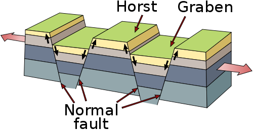
In geology, horst and graben (or range and valley) refers to topography consisting of alternating raised and lowered fault blocks known as horsts and grabens. The features are created by normal faulting and rifting caused by crustal extension. [1] Horst and graben are formed when normal faults of opposite dip occur in pairs with parallel strike, and are always formed together. Each feature can range in size from a few centimeters up to tens of kilometers, and the vertical displacement can be up to several thousand meters. The movement on either side of each block is typically equal, resulting in little tilting. [2]

Contents

Features

Horst

A horst is a section of crust that has been lifted relative to the blocks on either side, which is a result of its bounding faults dipping away from each other. [2] Horsts can form features such as plateaus, mountain ranges or ridges on either side of the valleys. [1]

Graben

A graben is a section of crust that has lowered relative to the blocks on either side, which is a result of its bounding faults dipping towards each other. [2] The plural of graben can be either graben or grabens. Graben form low-lying features such as basins and rift valleys. [1] [2] They can be very long relative to their width.

Examples

See also

Related Research Articles

<span class="mw-page-title-main">Basin and Range Province</span> Physiographic region extending through western United States and Mexico

The Basin and Range Province is a vast physiographic region covering much of the inland Western United States and northwestern Mexico. It is defined by unique basin and range topography, characterized by abrupt changes in elevation, alternating between narrow faulted mountain chains and flat arid valleys or basins. The physiography of the province is the result of tectonic extension that began around 17 million years ago in the early Miocene epoch.

<span class="mw-page-title-main">Graben</span> Depressed block of planetary crust bordered by parallel normal faults

In geology, a graben is a depressed block of the crust of a planet or moon, bordered by parallel normal faults.

<span class="mw-page-title-main">Horst (geology)</span> Raised fault block bounded by normal faults

In physical geography and geology, a horst is a raised fault block bounded by normal faults. Horsts are typically found together with grabens. While a horst lifted or remains stationary, the grabens on either side subside. This is often caused by extensional forces pulling apart the crust. Horsts may represent features such as plateaus, mountains, or ridges on either side of a valley. Horsts can range in size from small fault-blocks, up to large regions of stable continent that have not been not folded or warped by tectonic forces.

<span class="mw-page-title-main">Rift</span> Geological linear zone where the lithosphere is being pulled apart

In geology, a rift is a linear zone where the lithosphere is being pulled apart and is an example of extensional tectonics. Typical rift features are a central linear downfaulted depression, called a graben, or more commonly a half-graben with normal faulting and rift-flank uplifts mainly on one side. Where rifts remain above sea level they form a rift valley, which may be filled by water forming a rift lake. The axis of the rift area may contain volcanic rocks, and active volcanism is a part of many, but not all, active rift systems.

<span class="mw-page-title-main">Geology of the United States</span> National geology

The richly textured landscape of the United States is a product of the dueling forces of plate tectonics, weathering and erosion. Over the 4.5 billion-year history of the Earth, tectonic upheavals and colliding plates have raised great mountain ranges while the forces of erosion and weathering worked to tear them down. Even after many millions of years, records of Earth's great upheavals remain imprinted as textural variations and surface patterns that define distinctive landscapes or provinces.

<span class="mw-page-title-main">Narmada River</span> River of central India in a rift valley

The Narmada River, previously also known as Narbada or anglicised as Nerbudda, is the 5th longest river and overall longest west-flowing river in India. It is also the largest flowing river in the state of Madhya Pradesh. This river flows through the states of Madhya Pradesh and Gujarat in India. It is also known as the "Life Line of Madhya Pradesh and Gujarat" due to its huge contribution to the two states in many ways. The Narmada River rises from the Amarkantak Plateau in Anuppur district Madhya Pradesh. It forms the traditional boundary between North India and South India and flows westwards over a length of 1,312 km (815.2 mi) before draining through the Gulf of Khambhat into the Arabian Sea, 30 km (18.6 mi) west of Bharuch city of Gujarat.

<span class="mw-page-title-main">Satpura Range</span> Hill range in central India

The Satpura Range is a range of hills in central India. The range rises in eastern Gujarat running east through the border of Maharashtra and Madhya Pradesh and ends in Chhattisgarh. The range parallels the Vindhya Range to the north, and these two east–west ranges divide Indian Subcontinent into the Indo-Gangetic plain of northern India and the Deccan Plateau of the south. The Narmada River originates from north-eastern end of Satpura in Amarkantak, and runs in the depression between the Satpura and Vindhya ranges, draining the northern slope of the Satpura range, running west towards the Arabian Sea. The Tapti River originates in the eastern-central part of Satpura, crossing the range in the center and running west at the range's southern slopes before meeting the Arabian Sea at Surat, draining the central and southern slopes of the range. Multai, the place of Tapi river origin is located about 465 kilometer far, south-westerly to Amarkantak, separated across by the hill range. The Godavari River and its tributaries drain the Deccan plateau, which lies south of the range, and the Mahanadi River drains the easternmost portion of the range. The Godavari and Mahanadi rivers flow into the Bay of Bengal. At its eastern end, the Satpura range meets the hills of the Chotanagpur Plateau. The Satpura Range is a horst mountain and is flanked by Narmada Graben in the north and much smaller but parallel Tapi Graben in the south.

<span class="mw-page-title-main">Mountain formation</span> Geological processes that underlie the formation of mountains

Mountain formation refers to the geological processes that underlie the formation of mountains. These processes are associated with large-scale movements of the Earth's crust. Folding, faulting, volcanic activity, igneous intrusion and metamorphism can all be parts of the orogenic process of mountain building. The formation of mountains is not necessarily related to the geological structures found on it.

<span class="mw-page-title-main">Fault block</span> Large blocks of rock created by tectonic and localized stresses in Earths crust

Fault blocks are very large blocks of rock, sometimes hundreds of kilometres in extent, created by tectonic and localized stresses in Earth's crust. Large areas of bedrock are broken up into blocks by faults. Blocks are characterized by relatively uniform lithology. The largest of these fault blocks are called crustal blocks. Large crustal blocks broken off from tectonic plates are called terranes. Those terranes which are the full thickness of the lithosphere are called microplates. Continent-sized blocks are called variously microcontinents, continental ribbons, H-blocks, extensional allochthons and outer highs.

Extensional tectonics is concerned with the structures formed by, and the tectonic processes associated with, the stretching of a planetary body's crust or lithosphere.

<span class="mw-page-title-main">Basin and range topography</span> Alternating landscape of parallel mountain ranges and valleys

Basin and range topography is characterized by alternating parallel mountain ranges and valleys. It is a result of crustal extension due to mantle upwelling, gravitational collapse, crustal thickening, or relaxation of confining stresses. The extension results in the thinning and deformation of the upper crust, causing it to fracture and create a series of long parallel normal faults. This results in block faulting, where the blocks of rock between the normal faults either subside, uplift, or tilt. The movement of these blocks results in the alternating valleys and mountains. As the crust thins, it also allows heat from the mantle to more easily melt rock and form magma, resulting in increased volcanic activity.

<span class="mw-page-title-main">Afar Triple Junction</span> Place where three tectonic rifts meet in East Africa

The Afar Triple Junction is located along a divergent plate boundary dividing the Nubian, Somali, and Arabian plates. This area is considered a present-day example of continental rifting leading to seafloor spreading and producing an oceanic basin. Here, the Red Sea Rift meets the Aden Ridge and the East African Rift. The latter extends a total of 6,500 kilometers (4,000 mi) from the Afar Triangle to Mozambique.

This is a list of articles related to plate tectonics and tectonic plates.

The Cheshire Basin is a late Palaeozoic and Mesozoic sedimentary basin extending under most of the county of Cheshire in northwest England. It extends northwards into the Manchester area and south into Shropshire. The basin possesses something of the character of a half-graben as its deepest extent is along its eastern and southeastern margins, where it is well defined by a series of sub-parallel faults, most important of which is the Red Rock Fault. These faults divide the basin from the older Carboniferous rocks of the Peak District and the North Staffordshire Coalfield.

Tectonic subsidence is the sinking of the Earth's crust on a large scale, relative to crustal-scale features or the geoid. The movement of crustal plates and accommodation spaces produced by faulting brought about subsidence on a large scale in a variety of environments, including passive margins, aulacogens, fore-arc basins, foreland basins, intercontinental basins and pull-apart basins. Three mechanisms are common in the tectonic environments in which subsidence occurs: extension, cooling and loading.

<span class="mw-page-title-main">Half-graben</span> Geological structure bounded by a fault along one side of its boundaries

A half-graben is a geological structure bounded by a fault along one side of its boundaries, unlike a full graben where a depressed block of land is bordered by parallel faults.

<span class="mw-page-title-main">Tilted block faulting</span>

Tilted block faulting, also called rotational block faulting, is a mode of structural evolution in extensional tectonic events, a result of tectonic plates stretching apart. When the upper lithospheric crust experiences extensional pressures, the brittle crust fractures, creating detachment faults. These normal faults express themselves on a regional scale; upper crust fractures into tilted fault blocks, and ductile lower crust ascends. This results in uplift, cooling, and exhumation of ductilely deformed deeper crust. The large unit of tilted blocks and associated crust can form an integral part of metamorphic core complexes, which are found on both continental and oceanic crust.

<span class="mw-page-title-main">Northern North Sea basin</span>

The North Sea is part of the Atlantic Ocean in northern Europe. It is located between Norway and Denmark in the east, Scotland and England in the west, Germany, the Netherlands, Belgium and France in the south.

<span class="mw-page-title-main">Tectonics of Mars</span>

Like the Earth, the crustal properties and structure of the surface of Mars are thought to have evolved through time; in other words, as on Earth, tectonic processes have shaped the planet. However, both the ways this change has happened and the properties of the planet's lithosphere are very different when compared to the Earth. Today, Mars is believed to be largely tectonically inactive. However, observational evidence and its interpretation suggests that this was not the case further back in Mars' geological history.

<span class="mw-page-title-main">Canadian Arctic Rift System</span> North American geological structure

The Canadian Arctic Rift System is a major North American geological structure extending from the Labrador Sea in the southeast through Davis Strait, Baffin Bay and the Arctic Archipelago in the northwest. It consists of a series of interconnected rifts that formed during the Paleozoic, Mesozoic and Cenozoic eras. Extensional stresses along the entire length of the rift system have resulted in a variety of tectonic features, including grabens, half-grabens, basins and faults.

References

  1. 1 2 3 4 "Horst and Graben". National Park Service . 2020-04-22.
  2. 1 2 3 4 "horst and graben". Encyclopædia Britannica .
  3. Valdiya, K. S. (2015-11-26). The Making of India: Geodynamic Evolution. Springer. ISBN   9783319250298.
  4. Valdiya, K.S.; Sanwal, Jaishri (2017-01-01). "Satpura Horst and Narmada–Tapi Grabens". Neotectonism in the Indian Subcontinent - Landscape Evolution. Developments in Earth Surface Processes. Vol. 22. pp. 237–247. doi:10.1016/B978-0-444-63971-4.00010-4. ISBN   9780444639714. ISSN   0928-2025.