
An orogeny is an event that leads to both structural deformation and compositional differentiation of the Earth's lithosphere at convergent plate margins. An orogen or orogenic belt develops when a continental plate crumples and is uplifted to form one or more mountain ranges; this involves a series of geological processes collectively called orogenesis. A synorogenic event is one that occurs during an orogeny.

In geology, a fault is a planar fracture or discontinuity in a volume of rock across which there has been significant displacement as a result of rock-mass movements. Large faults within the Earth's crust result from the action of plate tectonic forces, with the largest forming the boundaries between the plates, such as subduction zones or transform faults. Energy release associated with rapid movement on active faults is the cause of most earthquakes. Faults may also displace slowly, by aseismic creep.

The Basin and Range Province is a vast physiographic region covering much of the inland Western United States and northwestern Mexico. It is defined by unique basin and range topography, characterized by abrupt changes in elevation, alternating between narrow faulted mountain chains and flat arid valleys or basins. The physiography of the province is the result of tectonic extension that began around 17 million years ago in the early Miocene epoch.

In geology, a rift is a linear zone where the lithosphere is being pulled apart and is an example of extensional tectonics.

A monocline is a step-like fold in rock strata consisting of a zone of steeper dip within an otherwise horizontal or gently-dipping sequence.
The Lewis Overthrust is a geologic thrust fault structure of the Rocky Mountains found within the bordering national parks of Glacier in Montana, United States and Waterton Lakes in Alberta, Canada. The structure was created due to the collision of tectonic plates about 170 million years ago that drove a several mile thick wedge of rock 50 mi (80 km) eastwards, causing it to overlie softer Cretaceous age rock that is 400 to 500 million years younger.

Décollement is a gliding plane between two rock masses, also known as a basal detachment fault. Décollements are a deformational structure, resulting in independent styles of deformation in the rocks above and below the fault. They are associated with both compressional settings and extensional settings.
Extensional tectonics is concerned with the structures formed by, and the tectonic processes associated with, the stretching of a planetary body's crust or lithosphere.

Detachment faulting is associated with large-scale extensional tectonics. Detachment faults often have very large displacements and juxtapose unmetamorphosed hanging walls against medium to high-grade metamorphic footwalls that are called metamorphic core complexes. They are thought to have formed as either initially low-angle structures or by the rotation of initially high-angle normal faults modified also by the isostatic effects of tectonic denudation. Examples of detachment faulting include:

In structural geology inversion or basin inversion relates to the relative uplift of a sedimentary basin or similar structure as a result of crustal shortening. This normally excludes uplift developed in the footwalls of later extensional faults, or uplift caused by mantle plumes. "Inversion" can also refer to individual faults, where an extensional fault is reactivated in the opposite direction to its original movement.

Basin and range topography is an alternating landscape of parallel mountain ranges and valleys. It is a result of crustal extension/stretching of the lithosphere due to mantle upwelling, gravitational collapse, crustal thickening, or relaxation of confining stresses. Crustal extension causes the thinning and deformation of the upper crust in an orientation perpendicular to the direction of extension. As the plates pull apart, they thin allowing the hot mantle to rise close to the surface. When the crust is extended it fractures along a fault plane, creating a series of long parallel normal faults. Between these normal faults are blocks, which subside, get uplifted or tilted. This is known as block faulting. Basins are formed due to subsidence of a block, while the blocks adjacent to the subsidence gets uplifted creating ranges. Normal faults are on both sides of the blocks; creating alternating elevated or subsided blocks, otherwise known as horst and graben. Basins and ranges can also be formed by blocks that are tilted causing one side to subside while the other side gets uplifted. These only have one side with a normal fault, this is known as tilted block faulting. Extension causes the plate to stretch, fracture and thin. Mountains rise and valleys drop, over a long period of time creating what we see as basin and range topography.
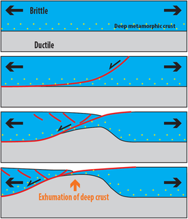
Metamorphic core complexes are exposures of deep crust exhumed in association with largely amagmatic extension. They form, and are exhumed, through relatively fast transport of middle and lower continental crust to the Earth's surface. During this process, high-grade metamorphic rocks are exposed below low-angle detachment faults that show ductile deformation on the lower side (footwall) with amphibolite- to greenschist-facies syndeformational metamorphism, and ductile-brittle to brittle deformation on the upper-side (hanging-wall) with tilted geometries.
Non-volcanic passive margins (NVPM) constitute one end member of the transitional crustal types that lie beneath passive continental margins; the other end member being volcanic passive margins (VPM). Transitional crust welds continental crust to oceanic crust along the lines of continental break-up. Both VPM and NVPM form during rifting, when a continent rifts to form a new ocean basin. NVPM are different from VPM because of a lack of volcanism. Instead of intrusive magmatic structures, the transitional crust is composed of stretched continental crust and exhumed upper mantle. NVPM are typically submerged and buried beneath thick sediments, so they must be studied using geophysical techniques or drilling. NVPM have diagnostic seismic, gravity, and magnetic characteristics that can be used to distinguish them from VPM and for demarcating the transition between continental and oceanic crust.
A half-graben is a geological structure bounded by a fault along one side of its boundaries, unlike a full graben where a depressed block of land is bordered by parallel faults.

The North Sea is part of the Atlantic Ocean in northern Europe. It is located between Norway and Denmark in the east, Scotland and England in the west, Germany, the Netherlands, Belgium and France in the south.

The Kutai sedimentary basin extends from the central highlands of Borneo, across the eastern coast of the island and into the Makassar Strait. With an area of 60,000 km2, and depths up to 15 km, the Kutai is the largest and deepest Tertiary age basin in Indonesia. Plate tectonic evolution in the Indonesian region of SE Asia has produced a diverse array of basins in the Cenozoic. The Kutai is an extensional basin in a general foreland setting. Its geologic evolution begins in the mid Eocene and involves phases of extension and rifting, thermal sag, and isostatic subsidence. Rapid, high volume, sedimentation related to uplift and inversion began in the Early Miocene. The different stages of Kutai basin evolution can be roughly correlated to regional and local tectonic events. It is also likely that regional climate, namely the onset of the equatorial ever wet monsoon in early Miocene, has affected the geologic evolution of Borneo and the Kutai basin through the present day. Basin fill is ongoing in the lower Kutai basin, as the modern Mahakam River delta progrades east across the continental shelf of Borneo.
In geology, the term exhumation refers to the process by which a parcel of rock, approaches Earth's surface.

Pre-collisional Himalaya is a term describing the arrangement of the Himalayan rock units before the mountain-building process resulted from the collision between the continents of Asia and India. The collision began in the Cenozoic and it is a type locality of a continental-continental collision. The reconstruction of the initial configuration of the rock units and the relationship between them is highly controversial, and major concerns relate to the arrangements of the different rock units in three dimensions. Several models have been advanced to explain the possible arrangements and petrogenesis of the rock units.

Huangling Complex represents a group of rock units appear in the middle of Yangtze Block in South China, distributed across Yixingshan, Zigui, Huangling and Yichang counties. The group of rock involves nonconformity that sedimentary rocks overlie the metamorphic basement. It is a 73-km long, asymmetrical dome-shaped anticline with axial plane orientating in north-south direction. It has a steeper west flank and a gentler east flank. Basically, there are three tectonic units from the anticline core to the rim, including Archean to Paleoproterozoic metamorphic basement, Neoproterozoic to Jurassic sedimentary rocks and Cretaceous fluvial deposit sedimentary cover. The northern part of the core is mainly tonalite-trondhjemite-gneiss (TTG) and Cretaceous sedimentary rock, it is called the Archean Kongling Complex. The middle of the core is mainly the Neoproterozoic granitoid. The southern part of the core is the Neoproterozoic potassium granite. Two basins are situated on the western and eastern flanks of the core respectively, including the Zigui basin and Dangyang basin. Both basins are synforms while Zigui basin has a larger extent of folding. Yuanan Graben and Jingmen Graben are found within Dangyang Basin area. Huangling Complex is an important area that helps unravel the tectonic history of South China Craton because it has well-exposed layers of rock units from Archean basement rock to Cretaceous sedimentary rock cover due to the erosion of the anticline.
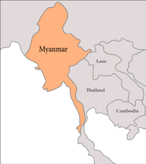
The geology of Myanmar is shaped by dramatic, ongoing tectonic processes controlled by shifting tectonic components as the Indian plate slides northwards and towards Southeast Asia. Myanmar spans across parts of three tectonic plates separated by north-trending faults. To the west, a highly oblique subduction zone separates the offshore Indian plate from the Burma microplate, which underlies most of the country. In the center-east of Myanmar, a right lateral strike slip fault extends from south to north across more than 1,000 km (620 mi). These tectonic zones are responsible for large earthquakes in the region. The India-Eurasia plate collision which initiated in the Eocene provides the last geological pieces of Myanmar, and thus Myanmar preserves a more extensive Cenozoic geological record as compared to records of the Mesozoic and Paleozoic eras. Myanmar is physiographically divided into three regions: the Indo-Burman Range, Myanmar Central Belt and the Shan Plateau; these all display an arcuate shape bulging westwards. The varying regional tectonic settings of Myanmar not only give rise to disparate regional features, but they also foster the formation of petroleum basins and a diverse mix of mineral resources.


