Geology is a branch of natural science concerned with the Earth and other astronomical objects, the rocks of which they are composed, and the processes by which they change over time. Modern geology significantly overlaps all other Earth sciences, including hydrology. It is integrated with Earth system science and planetary science.

A batholith is a large mass of intrusive igneous rock, larger than 100 km2 (40 sq mi) in area, that forms from cooled magma deep in Earth's crust. Batholiths are almost always made mostly of felsic or intermediate rock types, such as granite, quartz monzonite, or diorite.

In geology, a fault is a planar fracture or discontinuity in a volume of rock across which there has been significant displacement as a result of rock-mass movements. Large faults within Earth's crust result from the action of plate tectonic forces, with the largest forming the boundaries between the plates, such as the megathrust faults of subduction zones or transform faults. Energy release associated with rapid movement on active faults is the cause of most earthquakes. Faults may also displace slowly, by aseismic creep.

A salt dome is a type of structural dome formed when salt intrudes into overlying rocks in a process known as diapirism. Salt domes can have unique surface and subsurface structures, and they can be discovered using techniques such as seismic reflection. They are important in petroleum geology as they can function as petroleum traps.

In structural geology, a fold is a stack of originally planar surfaces, such as sedimentary strata, that are bent or curved ("folded") during permanent deformation. Folds in rocks vary in size from microscopic crinkles to mountain-sized folds. They occur as single isolated folds or in periodic sets. Synsedimentary folds are those formed during sedimentary deposition.

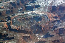
Upheaval Dome is an enigmatic geological structure in San Juan County, Utah, United States, that has been variously interpreted as a meteorite impact structure or a salt dome. The structure lies 22 miles (35 km) southwest of the city of Moab, Utah, in the Island in the Sky section of Canyonlands National Park.
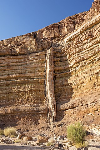
In geology, a dike or dyke is a sheet of rock that is formed in a fracture of a pre-existing rock body. Dikes can be either magmatic or sedimentary in origin. Magmatic dikes form when magma flows into a crack then solidifies as a sheet intrusion, either cutting across layers of rock or through a contiguous mass of rock. Clastic dikes are formed when sediment fills a pre-existing crack.
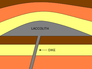
A laccolith is a body of intrusive rock with a dome-shaped upper surface and a level base, fed by a conduit from below. A laccolith forms when magma rising through the Earth's crust begins to spread out horizontally, prying apart the host rock strata. The pressure of the magma is high enough that the overlying strata are forced upward, giving the laccolith its dome-like form.

In structural geology, an anticline is a type of fold that is an arch-like shape and has its oldest beds at its core, whereas a syncline is the inverse of an anticline. A typical anticline is convex up in which the hinge or crest is the location where the curvature is greatest, and the limbs are the sides of the fold that dip away from the hinge. Anticlines can be recognized and differentiated from antiforms by a sequence of rock layers that become progressively older toward the center of the fold. Therefore, if age relationships between various rock strata are unknown, the term antiform should be used.

A diapir is a type of igneous intrusion in which a more mobile and ductily deformable material is forced into brittle overlying rocks. Depending on the tectonic environment, diapirs can range from idealized mushroom-shaped Rayleigh–Taylor-instability-type structures in regions with low tectonic stress such as in the Gulf of Mexico to narrow dikes of material that move along tectonically induced fractures in surrounding rock.

In geology, an igneous intrusion is a body of intrusive igneous rock that forms by crystallization of magma slowly cooling below the surface of the Earth. Intrusions have a wide variety of forms and compositions, illustrated by examples like the Palisades Sill of New York and New Jersey; the Henry Mountains of Utah; the Bushveld Igneous Complex of South Africa; Shiprock in New Mexico; the Ardnamurchan intrusion in Scotland; and the Sierra Nevada Batholith of California.

Salt tectonics, or halokinesis, or halotectonics, is concerned with the geometries and processes associated with the presence of significant thicknesses of evaporites containing rock salt within a stratigraphic sequence of rocks. This is due both to the low density of salt, which does not increase with burial, and its low strength.
In geology, a chonolith is a type of igneous rock intrusion. Igneous rock intrusions are bodies of igneous rock that are formed by the crystallization of cooled magma below the Earth’s surface. These formations are termed intrusive rocks due the magma intruding rock layers but never reaching the earth’s surface. However, sometimes portions of plutons can become exposed at the Earth’s surface and thus the minerals can be observed since they are large enough. The different plutonic formations are named based on the different shapes that the cooled crystallized magma takes. However, all plutonic formations that have irregular shapes and do not share the same characteristics as other plutonic structures are termed chonoliths. Other plutonic structures that have specific shapes include: dikes, sills, laccoliths and sheets. Another unique characteristic of chonoliths is that there is a floor or base present which is typically absent in other types of intrusions.
The methods of pluton emplacement are the ways magma is accommodated in a host rock where the final result is a pluton. The methods of pluton emplacement are not yet fully understood, but there are many different proposed pluton emplacement mechanisms. Stoping, diapirism and ballooning are the widely accepted mechanisms. There is now evidence of incremental emplacement of plutons.
Mountains are widely distributed across the surface of Io, the innermost large moon of Jupiter. There are about 115 named mountains; the average length is 157 km (98 mi) and the average height is 6,300 m (20,700 ft). The longest is 570 km (350 mi), and the highest is Boösaule Montes, at 17,500 metres (57,400 ft), taller than any mountain on Earth. Ionian mountains often appear as large, isolated structures; no global tectonic pattern is evident, unlike on Earth, where plate tectonics is dominant.

Salt surface structures are extensions of salt tectonics that form at the Earth's surface when either diapirs or salt sheets pierce through the overlying strata. They can occur in any location where there are salt deposits, namely in cratonic basins, synrift basins, passive margins and collisional margins. These are environments where mass quantities of water collect and then evaporate; leaving behind salt and other evaporites to form sedimentary beds. When there is a difference in pressure, such as additional sediment in a particular area, the salt beds – due to the unique ability of salt to behave as a fluid under pressure – form into new structures. Sometimes, these new bodies form subhorizontal or moderately dipping structures over a younger stratigraphic unit, which are called allochthonous salt bodies or salt surface structures.

The surface of Venus is dominated by geologic features that include volcanoes, large impact craters, and aeolian erosion and sedimentation landforms. Venus has a topography reflecting its single, strong crustal plate, with a unimodal elevation distribution that preserves geologic structures for long periods of time. Studies of the Venusian surface are based on imaging, radar, and altimetry data collected from several exploratory space probes, particularly Magellan, since 1961. Despite its similarities to Earth in size, mass, density, and possibly composition, Venus has a unique geology that is unlike Earth's. Although much older than Earth's, the surface of Venus is relatively young compared to other terrestrial planets, possibly due to a global-scale resurfacing event that buried much of the previous rock record. Venus is believed to have approximately the same bulk elemental composition as Earth, due to the physical similarities, but the exact composition is unknown. The surface conditions on Venus are more extreme than on Earth, with temperatures ranging from 453 to 473 °C and pressures of 95 bar. Venus lacks water, which makes crustal rock stronger and helps preserve surface features. The features observed provide evidence for the geological processes at work. Twenty feature types have been categorized thus far. These classes include local features, such as craters, coronae, and undae, as well as regional-scale features, such as planitiae, plana, and tesserae.

The Huangling Anticline or Complex represents a group of rock units that appear in the middle of the Yangtze Block in South China, distributed across Yixingshan, Zigui, Huangling, and Yichang counties. The group of rock involves nonconformity that sedimentary rocks overlie the metamorphic basement. It is a 73-km long, asymmetrical dome-shaped anticline with axial plane orientating in the north-south direction. It has a steeper west flank and a gentler east flank. Basically, there are three tectonic units from the anticline core to the rim, including Archean to Paleoproterozoic metamorphic basement, Neoproterozoic to Jurassic sedimentary rocks, and Cretaceous fluvial deposit sedimentary cover. The northern part of the core is mainly tonalite-trondhjemite-gneiss (TTG) and Cretaceous sedimentary rock called the Archean Kongling Complex. The middle of the core is mainly the Neoproterozoic granitoid. The southern part of the core is the Neoproterozoic potassium granite. Two basins are situated on the western and eastern flanks of the core, respectively, including the Zigui basin and Dangyang basin. Both basins are synforms while Zigui basin has a larger extent of folding. Yuanan Graben and Jingmen Graben are found within the Dangyang Basin area. The Huangling Anticline is an important area that helps unravel the tectonic history of the South China Craton because it has well-exposed layers of rock units from Archean basement rock to Cretaceous sedimentary rock cover due to the erosion of the anticline.

Salt deformation is the change of shape of natural salt bodies in response to forces and mechanisms that controls salt flow. Such deformation can generate large salt structures such as underground salt layers, salt diapirs or salt sheets at the surface. Strictly speaking, salt structures are formed by rock salt that is composed of pure halite (NaCl) crystal. However, most halite in nature appears in impure form, therefore rock salt usually refers to all rocks that composed mainly of halite, sometimes also as a mixture with other evaporites such as gypsum and anhydrite. Earth's salt deformation generally involves such mixed materials.

Volcanic and igneous plumbing systems (VIPS) consist of interconnected magma channels and chambers through which magma flows and is stored within Earth's crust. Volcanic plumbing systems can be found in all active tectonic settings, such as mid-oceanic ridges, subduction zones, and mantle plumes, when magmas generated in continental lithosphere, oceanic lithosphere, and in the sub-lithospheric mantle are transported. Magma is first generated by partial melting, followed by segregation and extraction from the source rock to separate the melt from the solid. As magma propagates upwards, a self-organised network of magma channels develops, transporting the melt from lower crust to upper regions. Channelled ascent mechanisms include the formation of dykes and ductile fractures that transport the melt in conduits. For bulk transportation, diapirs carry a large volume of melt and ascent through the crust. When magma stops ascending, or when magma supply stops, magma emplacement occurs. Different mechanisms of emplacement result in different structures, including plutons, sills, laccoliths and lopoliths.