Related Research Articles

A thrust fault is a break in the Earth's crust, across which older rocks are pushed above younger rocks.

In geology, a fault is a planar fracture or discontinuity in a volume of rock across which there has been significant displacement as a result of rock-mass movements. Large faults within Earth's crust result from the action of plate tectonic forces, with the largest forming the boundaries between the plates, such as the megathrust faults of subduction zones or transform faults. Energy release associated with rapid movement on active faults is the cause of most earthquakes. Faults may also displace slowly, by aseismic creep.

In geology, a graben is a depressed block of the crust of a planet or moon, bordered by parallel normal faults.

In geology, a rift is a linear zone where the lithosphere is being pulled apart and is an example of extensional tectonics. Typical rift features are a central linear downfaulted depression, called a graben, or more commonly a half-graben with normal faulting and rift-flank uplifts mainly on one side. Where rifts remain above sea level they form a rift valley, which may be filled by water forming a rift lake. The axis of the rift area may contain volcanic rocks, and active volcanism is a part of many, but not all, active rift systems.

The Maracaibo Basin, also known as Lake Maracaibo natural region, Lake Maracaibo depression or Lake Maracaibo Lowlands, is a foreland basin and one of the eight natural regions of Venezuela, found in the northwestern corner of Venezuela in South America. Covering over 36,657 square km, it is a hydrocarbon-rich region that has produced over 30 billion bbl of oil with an estimated 44 billion bbl yet to be recovered. The basin is characterized by a large shallow tidal estuary, Lake Maracaibo, located near its center. The Maracaibo basin has a complex tectonic history that dates back to the Jurassic period with multiple evolution stages. Despite its complexity, these major tectonic stages are well preserved within its stratigraphy. This makes The Maracaibo basin one of the most valuable basins for reconstructing South America's early tectonic history.

The Sevier orogeny was a mountain-building event that affected western North America from northern Canada to the north to Mexico to the south.
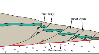
Thrust tectonics or contractional tectonics is concerned with the structures formed by, and the tectonic processes associated with, the shortening and thickening of the crust or lithosphere. It is one of the three main types of tectonic regime, the others being extensional tectonics and strike-slip tectonics. These match the three types of plate boundary, convergent (thrust), divergent (extensional) and transform (strike-slip). There are two main types of thrust tectonics, thin-skinned and thick-skinned, depending on whether or not basement rocks are involved in the deformation. The principle geological environments where thrust tectonics is observed are zones of continental collision, restraining bends on strike-slip faults and as part of detached fault systems on some passive margins.

The Gulf of Suez Rift is a continental rift zone that was active between the Late Oligocene and the end of the Miocene. It represented a continuation of the Red Sea Rift until break-up occurred in the middle Miocene, with most of the displacement on the newly developed Red Sea spreading centre being accommodated by the Dead Sea Transform. During its brief post-rift history, the deepest part of the remnant rift topography has been filled by the sea, creating the Gulf of Suez.
The Upper Rhine Plain, Rhine Rift Valley or Upper Rhine Graben is a major rift, about 350-kilometre-long (220 mi) and on average 50-kilometre-wide (31 mi), between Basel in the south and the cities of Frankfurt/Wiesbaden in the north. Its southern section straddles the France–Germany border. It forms part of the European Cenozoic Rift System, which extends across Central Europe. The Upper Rhine Graben formed during the Oligocene, as a response to the evolution of the Alps to the south. It remains active to the present day. Today, the Rhine Rift Valley forms a downfaulted trough through which the river Rhine flows.
Transtension is the state in which a rock mass or area of the Earth's crust experiences both extensive and transtensive shear. As such, transtensional regions are characterised by both extensional structures and wrench structures. In general, many tectonic regimes that were previously defined as simple strike-slip shear zones are actually transtensional. It is unlikely that a deforming body will experience 'pure' extension or 'pure' strike-slip.
In geology, a basin is a region where subsidence generates accommodation space for the deposition of sediments. A pull-apart basin is a structural basin where two overlapping strike-slip faults or a fault bend create an area of crustal extension undergoing tension, which causes the basin to sink down. Frequently, the basins are rhombic or sigmoidal in shape. Dimensionally, basins are limited to the distance between the faults and the length of overlap.

The European Cenozoic Rift System (ECRIS) is a 1,100 km (680 mi) long system of rifts formed in the foreland of the Alps as the lithosphere responded to the effects of the Alpine and Pyrenean orogenies. The system began to form during the Late Eocene and parts remain seismically active today and are responsible for most of the larger earthquakes in Europe, north of the Alps.
A half-graben is a geological structure bounded by a fault along one side of its boundaries, unlike a full graben where a depressed block of land is bordered by parallel faults.
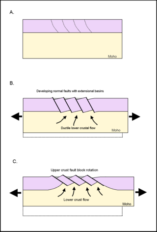
Tilted block faulting, also called rotational block faulting, is a mode of structural evolution in extensional tectonic events, a result of tectonic plates stretching apart. When the upper lithospheric crust experiences extensional pressures, the brittle crust fractures, creating detachment faults. These normal faults express themselves on a regional scale; upper crust fractures into tilted fault blocks, and ductile lower crust ascends. This results in uplift, cooling, and exhumation of ductilely deformed deeper crust. The large unit of tilted blocks and associated crust can form an integral part of metamorphic core complexes, which are found on both continental and oceanic crust.

Devana Chasma is a weak extensional rift zone on Venus, with a length of 4000 km, a width of 150–250 km, and a depth reaching 5 km. Most of the faults are facing north–south. The rift is located in Beta Regio, a 3000 km rise created by volcanic activity. Mantle plumes rising from the bottom are the reason behind the formation of the rift zone. The slow extension rates in the rift may be driven by the same reason.

The Gulf of Corinth basin, or Corinth rift, is an active extensional marine sedimentary basin thought to have started deforming during the late Miocene – Pleistocene epoch. The dimensions of the Gulf of Corinth are approximately 105 km long and 30 km wide with a basement depth of 3 km at its center. This half-graben basin is formed by a N100°E-oriented rift which separates the Peloponnese peninsula from the continental mainland of Greece. Currently the Corinth rift is opening at rate of 10–15 mm/yr, with respect to the Eurasia Plate. The basin is bounded by the Peloponnese highlands to the south and the westward-moving Anatolian Fault to the north. Major and minor fault planes make up the north and south margins, and its north-south extension is due to activity along an E-W to NW-SE oriented coastal southern margin. The basin's active and inactive faults create associated syn-rift sediment fill. These aspects provide a unique opportunity for scientists to study the tectonic and stratigraphic development of a rift, while further understanding how a basin is actually made.

The 1695 Linfen earthquake struck Shanxi Province in North China, Qing dynasty on May 18. Occurring at a shallow depth within the continental crust, the surface-wave magnitude 7.8 earthquake had a maximum intensity of XI on the China seismic intensity scale and Mercalli intensity scale. This devastating earthquake affected over 120 counties across eight provinces of modern-day China. An estimated 52,600 people died in the earthquake, although the death toll may have been 176,365.
The Ordos Block is a crustal block, that forms part of the larger North China Block (NCB). It is surrounded by active fault systems and has been a distinct block since at least the Mesozoic. It is bordered to the west by the Alxa Block, the westernmost part of the NCB, to the south by the Qinling orogenic belt, to the north by the Yanshan-Yinshan orogenic belt, part of the Central Asian Orogenic Belt and to the east by the Taihangshan mountain range, which forms part of the Trans-North China Orogen. The block is currently stable and large earthquakes are restricted to the bordering fault zones. It has been suggested that the block is currently undergoing anti-clockwise rotation with respect to the Eurasian Plate, as a result of the ongoing eastward spreading of the Tibetan Plateau, although this view has been challenged.
The 1626 Lingqiu earthquake had an epicentre in Lingqiu County, Shanxi Province during the Ming dynasty. The estimated surface wave magnitude (Ms ) 7.0 earthquake caused many buildings to collapse. Over 5,200 people were killed.
The Shanxi Rift System or Fen–Wei Rift System is a zone of active extensional tectonics that forms the eastern margin of the Ordos Block in northern China. The zone extends for at least 900 km (560 mi) and runs south-southwest to north-northeast. The individual rift basins that make up the rift system have an overall en echelon geometry, consistent with a right lateral sense of strike-slip displacement across the zone. The basins contain a thick sedimentary sequence of Neogene age, which ranges from 2.0 to 3.8 km in thickness. The rift system is continuous with the Weihe Basin to the southwest, which became active during the Paleogene. Rupture of the major normal faults that bound the Weihe and Shanxi rift basins has caused many large and damaging historical earthquakes, including the 1303 Hongdong, 1556 Shaanxi, 1626 Lingqiu, 1695 Linfen and 1815 Pinglu events.
References
- Ebinger, C.J.; Rosendahl, B.R.; Reynolds, D.J. (1987), "Tectonic model of the Malaŵi rift, Africa", Tectonophysics, 141 (1–3): 215–235, Bibcode:1987Tectp.141..215E, doi:10.1016/0040-1951(87)90187-9
- Ebinger, C. J. (1989), "Tectonic development of the western branch of the East African rift system", Geological Society of America Bulletin, 101 (7): 885–903, Bibcode:1989GSAB..101..885E, doi:10.1130/0016-7606(1989)101<0885:TDOTWB>2.3.CO;2
- Gawthorpe, R. L. & Hurst, J. M. 1993. Transfer zones in extensional basins: their structural style and influence on drainage development and stratigraphy. Journal of the Geological Society, London, 150, 1137–1152.
- C. K. Morley, R. A. Nelson (1990), "Transfer Zones in the East African Rift System and Their Relevance to Hydrocarbon Exploration in Rifts (1)", AAPG Bulletin, 74, doi:10.1306/0C9B2475-1710-11D7-8645000102C1865D
- Moustafa, A. R. 2002. Controls on the geometry of transfer zones in the Suez rift and northwest Red Sea: Implications for the structural geometry of rift systems. AAPG Bulletin. 86, 979–1002.
- Rosendahl, B. R. (1987), "Architecture of Continental Rifts with Special Reference to East Africa", Annual Review of Earth and Planetary Sciences, 15: 445–503, Bibcode:1987AREPS..15..445R, doi:10.1146/annurev.ea.15.050187.002305
- Amgad i. Younes, 1 Ken Mcclay (2002), "Development of accommodation zones in the Gulf of Suez-Red Sea rift, Egypt", AAPG Bulletin, 86, doi:10.1306/61EEDC10-173E-11D7-8645000102C1865D
{{citation}}: CS1 maint: numeric names: authors list (link) - Abeinomugisha, D. & Njabire N. 2012. Transfer Zones and Hydrocarbon Accumulation in the Albertine Graben of the East African Rift System AAPG Annual Convention and Exhibition. 2012.