Thrust fault

Last updated
Thrust fault in the Qilian Shan, China. The older (left, blue, and red) thrust over the younger (right, brown). Thrust fault Qilian Shan.jpg
Thrust fault in the Qilian Shan, China. The older (left, blue, and red) thrust over the younger (right, brown).
The Glencoul Thrust at Aird da Loch, Assynt in Scotland. The irregular grey mass of rock is formed of Archaean or Paleoproterozoic Lewisian gneisses thrust over well-bedded Cambrian quartzite, along the top of the younger unit. Glencoul Thrust Fault Zone in Scotland 2014.jpg
The Glencoul Thrust at Aird da Loch, Assynt in Scotland. The irregular grey mass of rock is formed of Archaean or Paleoproterozoic Lewisian gneisses thrust over well-bedded Cambrian quartzite, along the top of the younger unit.
Small thrust fault in the cliffs at Lilstock Bay, Somerset, England; displacement of about two metres (6.6 ft) Small thrust North verging.jpg
Small thrust fault in the cliffs at Lilstock Bay, Somerset, England; displacement of about two metres (6.6 ft)

A thrust fault is a break in the Earth's crust, across which older rocks are pushed above younger rocks.

Contents

Thrust geometry and nomenclature

Diagram of the evolution of a fault-bend fold or 'ramp anticline' above a thrust ramp, the ramp links decollements at the top of the green and yellow layers Faultbendfold.png
Diagram of the evolution of a fault-bend fold or 'ramp anticline' above a thrust ramp, the ramp links decollements at the top of the green and yellow layers
Diagram of the evolution of a fault propagation fold Fault-propagation fold.gif
Diagram of the evolution of a fault propagation fold
Development of thrust duplex by progressive failure of ramp footwall Duplex1.png
Development of thrust duplex by progressive failure of ramp footwall
Antiformal stack of thrust imbricates proved by drilling, Brooks Range Foothills, Alaska Antiformal stack.jpg
Antiformal stack of thrust imbricates proved by drilling, Brooks Range Foothills, Alaska

Reverse faults

A thrust fault is a type of reverse fault that has a dip of 45 degrees or less. [1] [2]

If the angle of the fault plane is lower (often less than 15 degrees from the horizontal [3] ) and the displacement of the overlying block is large (often in the kilometer range) the fault is called an overthrust or overthrust fault. [4] Erosion can remove part of the overlying block, creating a fenster (or window ) – when the underlying block is exposed only in a relatively small area. When erosion removes most of the overlying block, leaving island-like remnants resting on the lower block, the remnants are called klippen (singular klippe ).

Blind thrust faults

If the fault plane terminates before it reaches the Earth's surface, it is called a blind thrust fault. Because of the lack of surface evidence, blind thrust faults are difficult to detect until rupture. The destructive 1994 earthquake in Northridge, Los Angeles, California, was caused by a previously undiscovered blind thrust fault.

Because of their low dip, thrusts are also difficult to appreciate in mapping, where lithological offsets are generally subtle and stratigraphic repetition is difficult to detect, especially in peneplain areas.

Fault-bend folds

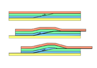
Thrust faults, particularly those involved in thin-skinned style of deformation, have a so-called ramp-flat geometry. Thrusts mainly propagate along zones of weakness within a sedimentary sequence, such as mudstones or halite layers; these parts of the thrust are called decollements . If the effectiveness of the decollement becomes reduced, the thrust will tend to cut up the section to a higher stratigraphic level until it reaches another effective decollement where it can continue as bedding parallel flat. The part of the thrust linking the two flats is known as a ramp and typically forms at an angle of about 15°–30° to the bedding. Continued displacement on a thrust over a ramp produces a characteristic fold geometry known as a ramp anticline or, more generally, as a fault-bend fold.

Fault-propagation folds

Fault-propagation folds form at the tip of a thrust fault where propagation along the decollement has ceased, but displacement on the thrust behind the fault tip continues. The formation of an asymmetric anticline-syncline fold pair accommodates the continuing displacement. As displacement continues, the thrust tip starts to propagate along the axis of the syncline. Such structures are also known as tip-line folds. Eventually, the propagating thrust tip may reach another effective decollement layer, and a composite fold structure will develop with fault-bending and fault-propagation folds' characteristics.

Thrust duplex

Duplexes occur where two decollement levels are close to each other within a sedimentary sequence, such as the top and base of a relatively strong sandstone layer bounded by two relatively weak mudstone layers. When a thrust that has propagated along the lower detachment, known as the floor thrust, cuts up to the upper detachment, known as the roof thrust, it forms a ramp within the stronger layer. With continued displacement on the thrust, higher stresses are developed in the footwall of the ramp due to the bend on the fault. This may cause renewed propagation along the floor thrust until it again cuts up to join the roof thrust. Further displacement then takes place via the newly created ramp. This process may repeat many times, forming a series of fault-bounded thrust slices known as imbricates or horses, each with the geometry of a fault-bend fold of small displacement. The final result is typically a lozenge-shaped duplex.

Most duplexes have only small displacements on the bounding faults between the horses, which dip away from the foreland. Occasionally, the displacement on the individual horses is more significant, such that each horse lies more or less vertically above the other; this is known as an antiformal stack or imbricate stack. If the individual displacements are still greater, the horses have a foreland dip.

Duplexing is a very efficient mechanism of accommodating the shortening of the crust by thickening the section rather than by folding and deformation. [5]

Tectonic environment

An example of thin-skinned deformation (thrusting) in Montana. Note that the white Madison Limestone is repeated, with one example in the foreground and another at a higher level to the upper right corner and top of the picture. SunRiver.JPG
An example of thin-skinned deformation (thrusting) in Montana. Note that the white Madison Limestone is repeated, with one example in the foreground and another at a higher level to the upper right corner and top of the picture.

Large overthrust faults occur in areas that have undergone great compressional forces.

These conditions exist in the orogenic belts that result from either two continental tectonic collisions or from subduction zone accretion.

The resultant compressional forces produce mountain ranges. The Himalayas, the Alps, and the Appalachians are prominent examples of compressional orogenies with numerous overthrust faults.

Thrust faults occur in the foreland basin, marginal to orogenic belts. Here, compression does not result in appreciable mountain building, which is mostly accommodated by folding and stacking of thrusts. Instead, thrust faults generally cause a thickening of the stratigraphic section. When thrusts are developed in orogens formed in previously rifted margins, inversion of the buried paleo-rifts can induce the nucleation of thrust ramps. [6]

Foreland basin thrusts also usually observe the ramp-flat geometry, with thrusts propagating within units at very low angle "flats" (at 1–5 degrees) and then moving up-section in steeper ramps (at 5–20 degrees) where they offset stratigraphic units. Thrusts have also been detected in cratonic settings, where "far-foreland" deformation has advanced into intracontinental areas. [6]

Thrusts and duplexes are also found in accretionary wedges in the ocean trench margin of subduction zones, where oceanic sediments are scraped off the subducted plate and accumulate. Here, the accretionary wedge must thicken by up to 200%, and this is achieved by stacking thrust fault upon thrust fault in a melange of disrupted rock, often with chaotic folding. Here, ramp flat geometries are not usually observed because the compressional force is at a steep angle to the sedimentary layering.

Thrust Fault Outcrop Thrust Fault Outcrop.jpg
Thrust Fault Outcrop

History

Thrust faults were unrecognised until the work of Arnold Escher von der Linth, Albert Heim and Marcel Alexandre Bertrand in the Alps working on the Glarus Thrust; Charles Lapworth, Ben Peach and John Horne working on parts of the Moine Thrust in the Scottish Highlands; Alfred Elis Törnebohm in the Scandinavian Caledonides and R. G. McConnell in the Canadian Rockies. [7] [8] The realisation that older strata could, via faulting, be found above younger strata was arrived at more or less independently by geologists in all these areas during the 1880s. Geikie in 1884 coined the term thrust-plane to describe this special set of faults. He wrote:

By a system of reversed faults, a group of strata is made to cover a great breadth of ground and actually to overlie higher members of the same series. The most extraordinary dislocations, however, are those to which for distinction we have given the name of Thrust-planes. They are strictly reversed faults, but with so low a hade that the rocks on their upthrown side have been, as it were, pushed horizontally forward. [9] [10]

Related Research Articles

<span class="mw-page-title-main">Fault (geology)</span> Fracture or discontinuity in rock across which there has been displacement

In geology, a fault is a planar fracture or discontinuity in a volume of rock across which there has been significant displacement as a result of rock-mass movements. Large faults within Earth's crust result from the action of plate tectonic forces, with the largest forming the boundaries between the plates, such as the megathrust faults of subduction zones or transform faults. Energy release associated with rapid movement on active faults is the cause of most earthquakes. Faults may also displace slowly, by aseismic creep.

<span class="mw-page-title-main">Fold (geology)</span> Stack of originally planar surfaces

In structural geology, a fold is a stack of originally planar surfaces, such as sedimentary strata, that are bent or curved ("folded") during permanent deformation. Folds in rocks vary in size from microscopic crinkles to mountain-sized folds. They occur as single isolated folds or in periodic sets. Synsedimentary folds are those formed during sedimentary deposition.

<span class="mw-page-title-main">Anticline</span> In geology, an anticline is a type of fold that is an arch-like shape

In structural geology, an anticline is a type of fold that is an arch-like shape and has its oldest beds at its core, whereas a syncline is the inverse of an anticline. A typical anticline is convex up in which the hinge or crest is the location where the curvature is greatest, and the limbs are the sides of the fold that dip away from the hinge. Anticlines can be recognized and differentiated from antiforms by a sequence of rock layers that become progressively older toward the center of the fold. Therefore, if age relationships between various rock strata are unknown, the term antiform should be used.

<span class="mw-page-title-main">Nappe</span> A large sheetlike body of rock that has been moved a considerable distance above a thrust fault

In geology, a nappe or thrust sheet is a large sheetlike body of rock that has been moved more than 2 km (1.2 mi) or 5 km (3.1 mi) above a thrust fault from its original position. Nappes form in compressional tectonic settings like continental collision zones or on the overriding plate in active subduction zones. Nappes form when a mass of rock is forced over another rock mass, typically on a low angle fault plane. The resulting structure may include large-scale recumbent folds, shearing along the fault plane, imbricate thrust stacks, fensters and klippes.

<span class="mw-page-title-main">Sevier orogeny</span> Mountain-building episode in North America

The Sevier orogeny was a mountain-building event that affected western North America from northern Canada to the north to Mexico to the south.

The Lewis Overthrust is a geologic thrust fault structure of the Rocky Mountains found within the bordering national parks of Glacier in Montana, United States and Waterton Lakes in Alberta, Canada. The structure was created due to the collision of tectonic plates about 59-75 million years ago that drove a several mile thick wedge of Precambrian rock 50 mi (80 km) eastwards, causing it to overlie softer Cretaceous age rock that is 1300 to 1400 million years younger.

<span class="mw-page-title-main">Décollement</span> Geological feature

Décollement is a gliding plane between two rock masses, also known as a basal detachment fault. Décollements are a deformational structure, resulting in independent styles of deformation in the rocks above and below the fault. They are associated with both compressional settings and extensional settings.

<span class="mw-page-title-main">Thrust tectonics</span> Concept in structural geology

Thrust tectonics or contractional tectonics is concerned with the structures formed by, and the tectonic processes associated with, the shortening and thickening of the crust or lithosphere. It is one of the three main types of tectonic regime, the others being extensional tectonics and strike-slip tectonics. These match the three types of plate boundary, convergent (thrust), divergent (extensional) and transform (strike-slip). There are two main types of thrust tectonics, thin-skinned and thick-skinned, depending on whether or not basement rocks are involved in the deformation. The principle geological environments where thrust tectonics is observed are zones of continental collision, restraining bends on strike-slip faults and as part of detached fault systems on some passive margins.

<span class="mw-page-title-main">Fracture (geology)</span> Geologic discontinuity feature, often a joint or fault

A fracture is any separation in a geologic formation, such as a joint or a fault that divides the rock into two or more pieces. A fracture will sometimes form a deep fissure or crevice in the rock. Fractures are commonly caused by stress exceeding the rock strength, causing the rock to lose cohesion along its weakest plane. Fractures can provide permeability for fluid movement, such as water or hydrocarbons. Highly fractured rocks can make good aquifers or hydrocarbon reservoirs, since they may possess both significant permeability and fracture porosity.

Strike-slip tectonics or wrench tectonics is a type of tectonics that is dominated by lateral (horizontal) movements within the Earth's crust. Where a zone of strike-slip tectonics forms the boundary between two tectonic plates, this is known as a transform or conservative plate boundary. Areas of strike-slip tectonics are characterised by particular deformation styles including: stepovers, Riedel shears, flower structures and strike-slip duplexes. Where the displacement along a zone of strike-slip deviates from parallelism with the zone itself, the style becomes either transpressional or transtensional depending on the sense of deviation. Strike-slip tectonics is characteristic of several geological environments, including oceanic and continental transform faults, zones of oblique collision and the deforming foreland of zones of continental collision.

<span class="mw-page-title-main">Salt tectonics</span> Geometries and processes associated with the presence of significant thicknesses of evaporites

Salt tectonics, or halokinesis, or halotectonics, is concerned with the geometries and processes associated with the presence of significant thicknesses of evaporites containing rock salt within a stratigraphic sequence of rocks. This is due both to the low density of salt, which does not increase with burial, and its low strength.

<span class="mw-page-title-main">Thin-skinned deformation</span>

Thin-skinned deformation is a style of deformation in plate tectonics at a convergent boundary which occurs with shallow thrust faults that only involves cover rocks, and not deeper basement rocks.

<span class="mw-page-title-main">Geology of the Pyrenees</span> European regional geology

The Pyrenees are a 430-kilometre-long, roughly east–west striking, intracontinental mountain chain that divide France, Spain, and Andorra. The belt has an extended, polycyclic geological evolution dating back to the Precambrian. The chain's present configuration is due to the collision between the microcontinent Iberia and the southwestern promontory of the European Plate. The two continents were approaching each other since the onset of the Upper Cretaceous (Albian/Cenomanian) about 100 million years ago and were consequently colliding during the Paleogene (Eocene/Oligocene) 55 to 25 million years ago. After its uplift, the chain experienced intense erosion and isostatic readjustments. A cross-section through the chain shows an asymmetric flower-like structure with steeper dips on the French side. The Pyrenees are not solely the result of compressional forces, but also show an important sinistral shearing.

<span class="mw-page-title-main">Section restoration</span>

In structural geology section restoration or palinspastic restoration is a technique used to progressively undeform a geological section in an attempt to validate the interpretation used to build the section. It is also used to provide insights into the geometry of earlier stages of the geological development of an area. A section that can be successfully undeformed to a geologically reasonable geometry, without change in area, is known as a balanced section.

<span class="mw-page-title-main">Detachment fold</span>

A detachment fold, in geology, occurs as layer parallel thrusting along a decollement develops without upward propagation of a fault; the accommodation of the strain produced by continued displacement along the underlying thrust results in the folding of the overlying rock units. As a visual aid, picture a rug on the floor. By placing your left foot on one end and pushing towards the other end of the rug, the rug slides across the floor (decollement) and folds upward. Figure 1, is a generalized representation of the geometry assumed by a detachment fault.

<span class="mw-page-title-main">Zagros fold and thrust belt</span> Geologic zone

The Zagros fold and thrust belt is an approximately 1,800-kilometre (1,100 mi) long zone of deformed crustal rocks, formed in the foreland of the collision between the Arabian Plate and the Eurasian Plate. It is host to one of the world's largest petroleum provinces, containing about 49% of the established hydrocarbon reserves in fold and thrust belts (FTBs) and about 7% of all reserves globally.

Thick-skinned deformation is a geological term which refers to crustal shortening that involves basement rocks and deep-seated faults as opposed to only the upper units of cover rocks above the basement which is known as thin-skinned deformation. While thin-skinned deformation is common in many different localities, thick-skinned deformation requires much more strain to occur and is a rarer type of deformation.

<span class="mw-page-title-main">Growth fault</span>

Growth faults are syndepositional or syn-sedimentary extensional faults that initiate and evolve at the margins of continental plates. They extend parallel to passive margins that have high sediment supply. Their fault plane dips mostly toward the basin and has long-term continuous displacement. Figure one shows a growth fault with a concave upward fault plane that has high updip angle and flattened at its base into zone of detachment or décollement. This angle is continuously changing from nearly vertical in the updip area to nearly horizontal in the downdip area.

<span class="mw-page-title-main">3D fold evolution</span>

In geology, 3D fold evolution is the study of the full three dimensional structure of a fold as it changes in time. A fold is a common three-dimensional geological structure that is associated with strain deformation under stress. Fold evolution in three dimensions can be broadly divided into two stages, namely fold growth and fold linkage. The evolution depends on fold kinematics, Fold mechanism, as well as a reporting of the history behind folds and relationships by which fold age is understood. There are several ways to reconstruct the evolution progress of folds, notably by using depositional evidence, geomorphological evidence and balanced restoration.

<span class="mw-page-title-main">Arkoma Basin</span> Geological feature in the United States

The Arkoma Basin is a peripheral foreland basin that extends from central west Arkansas to south eastern Oklahoma. The basin lies in between the Ozark Uplift and Oklahoma Platform to the north and Ouachita Mountains to the south and with an area of approximately 33,800 mi2. Along the southern edge of the basin, the Choctaw Fault is the boundary that separates the mountains from the basin itself. This basin is one of seven that lie along the front of the Ouachita and Appalachian mountain systems. This basin is Oklahoma's fourth largest in terms of natural gas production. Oil has been extracted locally, but not on a commercial scale. Coal was the first natural resource used commercially within the basin. Surface mapping of coal seams in the early part of the 20th century lead to the discovery of sub-surface features that indicated the presence of natural gas. Mansfield, Arkansas was the site of the first natural gas discovery in 1902.

References

  1. "dip slip". Earthquake Glossary. USGS . Retrieved 5 December 2017.
  2. "How are reverse faults different than thrust faults? In what way are they similar?". UCSB Science Line. University of California, Santa Barbara. 13 February 2012. Retrieved 5 December 2017.
  3. Crosby, G. W. (1967). "High Angle Dips at Erosional Edge of Overthrust Faults". Bulletin of Canadian Petroleum Geology. 15 (3): 219–229.
  4. Neuendorf, K. K. E.; Mehl Jr., J. P.; Jackson, J. A., eds. (2005). Glossary of Geology (5th ed.). Alexandria, Virginia: American Geological Institute. p. 462.
  5. Moore, Thomas E.; Potter, Christopher J. (2003). "Structural Plays in Ellesmerian Sequence and Correlative Strata of the National Petroleum Reserve, Alaska" (PDF). U.S. Geological Survey Open File Report. Open-File Report. 03–253. doi:10.3133/ofr03253 . Retrieved 5 July 2022.
  6. 1 2 Martins-Ferreira, Marco Antonio Caçador (April 2019). "Effects of initial rift inversion over fold-and-thrust development in a cratonic far-foreland setting". Tectonophysics. 757: 88–107. Bibcode:2019Tectp.757...88M. doi:10.1016/j.tecto.2019.03.009. S2CID   135346440.
  7. Peach, B. N., Horne, J., Gunn, W., Clough, C. T. & Hinxman, L. W. 1907. The Geological Structure of the North-west Highlands of Scotland (Memoirs of the Geological Survey, Scotland). His Majesty's Stationery Office, Glasgow.
  8. McConnell, R. G. (1887) Report on the geological structure of a portion of the Rocky Mountains: Geol. Surv. Canada Summ. Rept., 2, p. 41.
  9. "Thrust Tectonics". www.see.leeds.ac.uk.
  10. Archibald Geikie (November 13, 1884). "The Crystalline Rocks of the Scottish Highlands". Nature. 31 (785): 29–31. Bibcode:1884Natur..31...29G. doi: 10.1038/031029d0 .