Shear zone

Last updated
Pegmatite dyke offset by a steeply dipping dextral shear zone, Cap de Creus Pegmatite dyke offset by dextral shear zone.JPG
Pegmatite dyke offset by a steeply dipping dextral shear zone, Cap de Creus
Extensional ductile shear zone cutting dolomites of the Noonday Formation in Mosaic Canyon, Death Valley Ductile shear zone, Mosaic Canyon.jpg
Extensional ductile shear zone cutting dolomites of the Noonday Formation in Mosaic Canyon, Death Valley

In geology, a shear zone is a thin zone within the Earth's crust or upper mantle that has been strongly deformed, due to the walls of rock on either side of the zone slipping past each other. In the upper crust, where rock is brittle, the shear zone takes the form of a fracture called a fault. In the lower crust and mantle, the extreme conditions of pressure and temperature make the rock ductile. That is, the rock is capable of slowly deforming without fracture, like hot metal being worked by a blacksmith. Here the shear zone is a wider zone, in which the ductile rock has slowly flowed to accommodate the relative motion of the rock walls on either side.

Contents

Because shear zones are found across a wide depth-range, a great variety of different rock types with their characteristic structures are associated with shear zones.

General introduction

Diagram showing the major different types of shear zones. Displacement, shear strain, and depth distribution are also indicated. Shear zones.jpg
Diagram showing the major different types of shear zones. Displacement, shear strain, and depth distribution are also indicated.
Strength profile and change in rock type with depth in idealised fault/shear zone Brittle Ductile.png
Strength profile and change in rock type with depth in idealised fault/shear zone
Margin of a dextral sense ductile shear zone (about 20 m thick), showing transition from schists outside the zone to mylonites inside, Cap de Creus, Margin of dextral shear zone.JPG
Margin of a dextral sense ductile shear zone (about 20 m thick), showing transition from schists outside the zone to mylonites inside, Cap de Creus,

A shear zone is a zone of strong deformation (with a high strain rate) surrounded by rocks with a lower state of finite strain. It is characterised by a length to width ratio of more than 5:1. [1]

Shear zones form a continuum of geological structures, ranging from brittle shear zones (or faults) via brittle–ductile shear zones (or semibrittle shear zones), ductile–brittle to ductile shear zones. In brittle shear zones, the deformation is concentrated in a narrow fracture surface separating the wall rocks, whereas in a ductile shear zone the deformation is spread out through a wider zone, the deformation state varying continuously from wall to wall. Between these end-members, there are intermediate types of brittle–ductile (semibrittle) and ductile–brittle shear zones that can combine these geometric features in different proportions.

This continuum found in the structural geometries of shear zones reflects the different deformation mechanisms reigning in the crust, i.e. the changeover from brittle (fracturing) at or near the surface to ductile (flow) deformation with increasing depth. By passing through the brittle–semibrittle transition the ductile response to deformation is starting to set in. This transition is not tied to a specific depth, but rather occurs over a certain depth range - the so-called alternating zone, where brittle fracturing and plastic flow coexist. The main reason for this is found in the usually heteromineral composition of rocks, with different minerals showing different responses to applied stresses (for instance, under stress quartz reacts plastically long before feldspars do). Thus differences in lithology, grain size, and preexisting fabrics determine a different rheological response. Yet other, purely physical factors, influence the changeover depth as well, including:

In Scholz's model for a quartzo-feldspathic crust (with a geotherm taken from Southern California), the brittle–semibrittle transition starts at about 11 km depth with an ambient temperature of 300 °C. The underlying alternating zone then extends to roughly 16 km depth with a temperature of about 360 °C. [2] Below approximately 16 km depth, only ductile shear zones are found.

The seismogenic zone, in which earthquakes nucleate, is tied to the brittle domain, the schizosphere. Below an intervening alternating zone, there is the plastosphere. In the seismogenic layer, which occurs below an upper stability transition related to an upper seismicity cutoff (situated usually at about 4–5 km depth), true cataclasites start to appear. The seismogenic layer then yields to the alternating zone at 11 km depth. Yet big earthquakes can rupture both up to the surface and well into the alternating zone, sometimes even into the plastosphere.

Rocks produced in shear zones

The deformations in shear zones are responsible for the development of characteristic fabrics and mineral assemblages reflecting the reigning pressuretemperature (pT) conditions, flow type, movement sense, and deformation history. Shear zones are therefore very important structures for unravelling the history of a specific terrane.

Starting at the Earth's surface, the following rock types are usually encountered in a shear zone:

Both fault gouge and cataclasites are due to abrasive wear on brittle, seismogenic faults.

Mylonites start to occur with the onset of semibrittle behaviour in the alternating zone characterised by adhesive wear. Pseudotachylites can still be encountered here. By passing into greenschist facies conditions, the pseudotachylites disappear and only different types of mylonites persist. Striped gneisses are high-grade mylonites and occur at the very bottom of ductile shear zones.

Sense of shear

Asymmetric folds within a dextral sense shear zone, Cap de Creus Dextral shear folds.JPG
Asymmetric folds within a dextral sense shear zone, Cap de Creus
Asymmetric boudins of pegmatite within a dextral sense shear zone, Cap de Creus Asymmetric boudins in dextral shear zone.JPG
Asymmetric boudins of pegmatite within a dextral sense shear zone, Cap de Creus
Shear bands developed in a dextral sense shear zone, Cap de Creus Dextral shear bands.JPG
Shear bands developed in a dextral sense shear zone, Cap de Creus

The sense of shear in a shear zone (dextral, sinistral, reverse or normal) can be deduced by macroscopic structures and by a plethora of microtectonic indicators.

Indicators

The main macroscopic indicators are striations (slickensides), slickenfibers, and stretching– or mineral lineations. They indicate the direction of movement. With the aid of offset markers such as displaced layering and dykes, or the deflection (bending) of layering/foliation into a shear zone, one can additionally determine the sense of shear.

En echelon tension gash arrays (or extensional veins), characteristic of ductile-brittle shear zones, and sheath folds can also be valuable macroscopic shear-sense indicators.

Microscopic indicators consist of the following structures:

Width of shear zones and resulting displacements

The width of individual shear zones stretches from the grain scale to the kilometer scale. Crustal-scale shear zones (megashears) can become 10 km wide and consequently show very large displacements from tens to hundreds of kilometers.

Brittle shear zones (faults) usually widen with depth and with an increase in displacements.

Strain softening and ductility

Because shear zones are characterised by the localisation of strain, some form of strain softening must occur, in order for the affected host material to deform more plastically. The softening can be brought about by the following phenomena:

Furthermore, for a material to become more ductile (quasi-plastic) and undergo continuous deformation (flow) without fracturing, the following deformation mechanisms (on a grain scale) have to be taken into account:

Occurrence and examples of shear zones

Due to their deep penetration, shear zones are found in all metamorphic facies. Brittle shear zones are more or less ubiquitous in the upper crust. Ductile shear zones start at greenschist facies conditions and are therefore restricted to metamorphic terranes.

Shear zones can occur in the following geotectonic settings:

Shear zones are dependent neither on rock type nor on geological age. Most often they are not isolated in their occurrence, but commonly form fractal-scaled, linked up, anastomosing networks which reflect in their arrangement the underlying dominant sense of movement of the terrane at that time.

Some good examples of shear zones of the strike-slip type are the South Armorican Shear Zone and the North Armorican Shear Zone in Brittany, the North Anatolian Fault Zone in Turkey, and the Dead Sea Fault in Israel. Shear zones of the transform type are the San Andreas Fault in California, and the Alpine Fault in New Zealand. A shear zone of the thrust type is the Moine Thrust in northwestern Scotland. An example for the subduction zone setting is the Japan Median Tectonic Line. Detachment fault related shear zones can be found in southeastern California, e.g. the Whipple Mountain Detachment Fault. An example of a huge anastomosing shear-zone is the Borborema Shear Zone in Brazil.

Importance

The importance of shear zones lies in the fact that they are major zones of weakness in the Earth's crust, sometimes extending into the upper mantle. They can be very long-lived features and commonly show evidence of several overprinting stages of activity. Material can be transported upwards or downwards in them, the most important one being water circulating dissolved ions. This can bring about metasomatism in the host rocks and even re-fertilise mantle material.

Shear zones can host economically viable mineralizations, examples being important gold deposits in Precambrian terranes.

See also

Literature

Related Research Articles

<span class="mw-page-title-main">Structural geology</span> Science of the description and interpretation of deformation in the Earths crust

Structural geology is the study of the three-dimensional distribution of rock units with respect to their deformational histories. The primary goal of structural geology is to use measurements of present-day rock geometries to uncover information about the history of deformation (strain) in the rocks, and ultimately, to understand the stress field that resulted in the observed strain and geometries. This understanding of the dynamics of the stress field can be linked to important events in the geologic past; a common goal is to understand the structural evolution of a particular area with respect to regionally widespread patterns of rock deformation due to plate tectonics.

<span class="mw-page-title-main">Fault (geology)</span> Fracture or discontinuity in displaced rock

In geology, a fault is a planar fracture or discontinuity in a volume of rock across which there has been significant displacement as a result of rock-mass movements. Large faults within Earth's crust result from the action of plate tectonic forces, with the largest forming the boundaries between the plates, such as the megathrust faults of subduction zones or transform faults. Energy release associated with rapid movement on active faults is the cause of most earthquakes. Faults may also displace slowly, by aseismic creep.

<span class="mw-page-title-main">Metamorphism</span> Change of minerals in pre-existing rocks without melting into liquid magma

Metamorphism is the transformation of existing rock to rock with a different mineral composition or texture. Metamorphism takes place at temperatures in excess of 150 °C (300 °F), and often also at elevated pressure or in the presence of chemically active fluids, but the rock remains mostly solid during the transformation. Metamorphism is distinct from weathering or diagenesis, which are changes that take place at or just beneath Earth's surface.

<span class="mw-page-title-main">Mylonite</span> Metamorphic rock

Mylonite is a fine-grained, compact metamorphic rock produced by dynamic recrystallization of the constituent minerals resulting in a reduction of the grain size of the rock. Mylonites can have many different mineralogical compositions; it is a classification based on the textural appearance of the rock.

<span class="mw-page-title-main">Narryer Gneiss Terrane</span> Geological complex of ancient rocks in Western Australia

The Narryer Gneiss Terrane is a geological complex in Western Australia that is composed of a tectonically interleaved and polydeformed mixture of granite, mafic intrusions and metasedimentary rocks in excess of 3.3 billion years old, with the majority of the Narryer Gneiss Terrane in excess of 3.6 billion years old. The rocks have experienced multiple metamorphic events at amphibolite or granulite conditions, resulting in often complete destruction of original igneous or sedimentary (protolith) textures. Importantly, it contains the oldest known samples of the Earth's crust: samples of zircon from the Jack Hills portion of the Narryer Gneiss have been radiometrically dated at 4.4 billion years old, although the majority of zircon crystals are about 3.6-3.8 billion years old.

<span class="mw-page-title-main">Shear (geology)</span> Response of rock to deformation

In geology, shear is the response of a rock to deformation usually by compressive stress and forms particular textures. Shear can be homogeneous or non-homogeneous, and may be pure shear or simple shear. Study of geological shear is related to the study of structural geology, rock microstructure or rock texture and fault mechanics.

A cataclastic rock is a type of fault rock that has been wholly or partly formed by the progressive fracturing and comminution of existing rocks, a process known as cataclasis. Cataclasis involves the granulation, crushing, or milling of the original rock, then rigid-body rotation and translation of mineral grains or aggregates before lithification. Cataclastic rocks are associated with fault zones and impact event breccias.

<span class="mw-page-title-main">Texture (geology)</span>

In geology, texture or rock microstructure refers to the relationship between the materials of which a rock is composed. The broadest textural classes are crystalline, fragmental, aphanitic, and glassy. The geometric aspects and relations amongst the component particles or crystals are referred to as the crystallographic texture or preferred orientation. Textures can be quantified in many ways. The most common parameter is the crystal size distribution. This creates the physical appearance or character of a rock, such as grain size, shape, arrangement, and other properties, at both the visible and microscopic scale.

<span class="mw-page-title-main">Brittle–ductile transition zone</span> Strongest part of the Earths crust

The brittle-ductile transition zone is the zone of the Earth's crust that marks the transition from the upper, more brittle crust to the lower, more ductile crust. For quartz and feldspar-rich rocks in continental crust, the transition zone occurs at an approximate depth of 20 km, at temperatures of 250–400 °C. At this depth, rock becomes less likely to fracture, and more likely to deform ductilely by creep because the brittle strength of a material increases with confining pressure, while its ductile strength decreases with increasing temperature.

<span class="mw-page-title-main">Fracture (geology)</span> Geologic discontinuity feature, often a joint or fault

A fracture is any separation in a geologic formation, such as a joint or a fault that divides the rock into two or more pieces. A fracture will sometimes form a deep fissure or crevice in the rock. Fractures are commonly caused by stress exceeding the rock strength, causing the rock to lose cohesion along its weakest plane. Fractures can provide permeability for fluid movement, such as water or hydrocarbons. Highly fractured rocks can make good aquifers or hydrocarbon reservoirs, since they may possess both significant permeability and fracture porosity.

In geophysics and seismology, the seismogenic layer covers the range of depths within the crust or lithosphere in which most earthquakes originate. The thickness is heavily dependent on location. For oceanic crust, the seismogenic layer thickness can be 0 to 40 kilometres, and for continental crust, it ranges from 0 to 25 kilometres. It is also important to note that at subduction zones, there is one seismogenic layer being pushed on top of another. This can result in extremely deep earthquakes up to 700 kilometres (430 mi) in depth. The base of this layer represents the downwards change in deformation mechanism from elastic and frictional processes to a generally aseismic zone where ductile creep becomes the dominant process. The location of this change in deformation style is sometimes referred to as the brittle–ductile transition zone.

<span class="mw-page-title-main">Cataclasite</span> Rock found at geological faults

Cataclasite is a cohesive granular fault rock. Comminution, also known as cataclasis, is an important process in forming cataclasites. They fall into the category of cataclastic rocks which are formed through faulting or fracturing in the upper crust. Cataclasites are distinguished from fault gouge, which is incohesive, and fault breccia, which contains coarser fragments.

<span class="mw-page-title-main">Geodynamics</span> Study of dynamics of the Earth

Geodynamics is a subfield of geophysics dealing with dynamics of the Earth. It applies physics, chemistry and mathematics to the understanding of how mantle convection leads to plate tectonics and geologic phenomena such as seafloor spreading, mountain building, volcanoes, earthquakes, faulting. It also attempts to probe the internal activity by measuring magnetic fields, gravity, and seismic waves, as well as the mineralogy of rocks and their isotopic composition. Methods of geodynamics are also applied to exploration of other planets.

<span class="mw-page-title-main">Cleavage (geology)</span> Planar fabric in rock

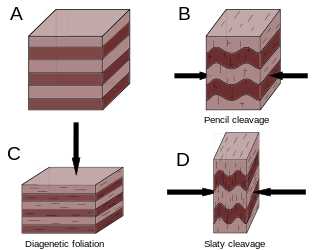
Cleavage, in structural geology and petrology, describes a type of planar rock feature that develops as a result of deformation and metamorphism. The degree of deformation and metamorphism along with rock type determines the kind of cleavage feature that develops. Generally, these structures are formed in fine grained rocks composed of minerals affected by pressure solution.

In geology, a deformation mechanism is a process occurring at a microscopic scale that is responsible for changes in a material's internal structure, shape and volume. The process involves planar discontinuity and/or displacement of atoms from their original position within a crystal lattice structure. These small changes are preserved in various microstructures of materials such as rocks, metals and plastics, and can be studied in depth using optical or digital microscopy.

<span class="mw-page-title-main">Fault gouge</span> Crushed rock found near faults

Fault gouge is a type of fault rock best defined by its grain size. It is found as incohesive fault rock, with less than 30% clasts >2mm in diameter. Fault gouge forms in near-surface fault zones with brittle deformation mechanisms. There are several properties of fault gouge that influence its strength including composition, water content, thickness, temperature, and the strain rate conditions of the fault.

In geology oblique foliation, steady state foliation or oblique fabric is a special type of a tectonically produced foliation or fabric, most commonly in quartz-rich layers. The microtectonic structure can be used to determine the shear sense in shear zones and their associated rocks, usually mylonites.

<span class="mw-page-title-main">Ductility (Earth science)</span>

In Earth science, ductility refers to the capacity of a rock to deform to large strains without macroscopic fracturing. Such behavior may occur in unlithified or poorly lithified sediments, in weak materials such as halite or at greater depths in all rock types where higher temperatures promote crystal plasticity and higher confining pressures suppress brittle fracture. In addition, when a material is behaving ductilely, it exhibits a linear stress vs strain relationship past the elastic limit.

In structural geology, strain partitioning is the distribution of the total strain experienced on a rock, area, or region, in terms of different strain intensity and strain type. This process is observed on a range of scales spanning from the grain – crystal scale to the plate – lithospheric scale, and occurs in both the brittle and plastic deformation regimes. The manner and intensity by which strain is distributed are controlled by a number of factors listed below.

<span class="mw-page-title-main">Volcanic and igneous plumbing systems</span> Magma chambers

Volcanic and igneous plumbing systems (VIPS) consist of interconnected magma channels and chambers through which magma flows and is stored within Earth's crust. Volcanic plumbing systems can be found in all active tectonic settings, such as mid-oceanic ridges, subduction zones, and mantle plumes, when magmas generated in continental lithosphere, oceanic lithosphere, and in the sub-lithospheric mantle are transported. Magma is first generated by partial melting, followed by segregation and extraction from the source rock to separate the melt from the solid. As magma propagates upwards, a self-organised network of magma channels develops, transporting the melt from lower crust to upper regions. Channelled ascent mechanisms include the formation of dykes and ductile fractures that transport the melt in conduits. For bulk transportation, diapirs carry a large volume of melt and ascent through the crust. When magma stops ascending, or when magma supply stops, magma emplacement occurs. Different mechanisms of emplacement result in different structures, including plutons, sills, laccoliths and lopoliths.

References

  1. Ramsay JG. (1987). The Techniques of Modern Structural Geology. Volume 2: Folds and Fractures. Academic Press. ISBN   0-12-576902-4
  2. Scholz CH. (2002). The mechanics of earthquakes and faulting. Cambridge University Press. ISBN   0-521-65540-4