Death Valley

Last updated

Death Valley
Death Valley from space.JPG
Death Valley as seen from Space Shuttle Columbia in October 1995
Relief map of California.png
Red pog.svg
Death Valley
California
Floor elevation−282 ft (−86 m) [1]
Area3,000 square miles (7,800 km2)
Geography
Coordinates 36°14′49″N116°49′01″W / 36.24694°N 116.81694°W / 36.24694; -116.81694 [2]
RiversFurnace Creek
Amargosa River

Death Valley is a desert valley in Eastern California, in the northern Mojave Desert, bordering the Great Basin Desert. It is thought to be the hottest place on Earth during summer. [3] Death Valley is home to the Timbisha tribe of Native Americans, formerly known as the Panamint Shoshone, who have inhabited the valley for at least the past millennium.

Contents

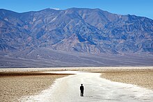
Death Valley's Badwater Basin is the point of lowest elevation in North America, at 282 feet (86 m) below sea level. [1] It is 84.6 miles (136.2 km) east-southeast of Mount Whitney — the highest point in the contiguous United States, with an elevation of 14,505 feet (4,421 m). [4] On the afternoon of July 10, 1913, the United States Weather Bureau recorded a high temperature of 134 °F (56.7 °C) at Furnace Creek in Death Valley, [5] which stands as the highest ambient air temperature ever recorded on the surface of the Earth. [6] This reading, however, and several others taken in that period are disputed by some modern experts. [7]

Lying mostly in Inyo County, California, near the border of California and Nevada, in the Great Basin, east of the Sierra Nevada mountains, Death Valley constitutes much of Death Valley National Park and is the principal feature of the Mojave and Colorado Deserts Biosphere Reserve. It runs from north to south between the Amargosa Range on the east and the Panamint Range on the west. The Grapevine Mountains and the Owlshead Mountains form its northern and southern boundaries, respectively. [8] It has an area of about 3,000 sq mi (7,800 km2). [9] The highest point in Death Valley National Park is Telescope Peak, in the Panamint Range, which has an elevation of 11,043 feet (3,366 m). [10]

Geology

Death Valley, California, July 3, 2017, Sentinel-2 true-color satellite image, scale 1:250,000. DeathValley03July17-250.tif
Death Valley, California, July 3, 2017, Sentinel-2 true-color satellite image, scale 1:250,000.
Map showing the system of once-interconnected Pleistocene lakes in eastern California (USGS) California Pleistocene Lakes USGS.png
Map showing the system of once-interconnected Pleistocene lakes in eastern California (USGS)

Death Valley is a graben—a downdropped block of land between two mountain ranges. [11] It lies at the southern end of a geological trough, Walker Lane, which runs north to Oregon. The valley is bisected by a right lateral strike slip fault system, comprising the Death Valley Fault and the Furnace Creek Fault. The eastern end of the left lateral Garlock Fault intersects the Death Valley Fault. Furnace Creek and the Amargosa River flow through part of the valley and eventually disappear into the sands of the valley floor.

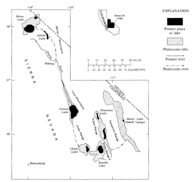
Death Valley also contains salt pans. According to current geological consensus, at various times during the middle of the Pleistocene era, which ended roughly 10,000–12,000 years ago, an inland lake, Lake Manly, formed in Death Valley. The lake was nearly 100 miles (160 km) long and 600 feet (180 m) deep. The end-basin in a chain of lakes that began with Mono Lake, in the north, and continued through basins down the Owens River Valley, through Searles and China Lakes and the Panamint Valley, to the immediate west. [12]

As the area turned to desert, the water evaporated, leaving an abundance of evaporitic salts, such as common sodium salts and borax, which were later exploited during the modern history of the region, primarily 1883 to 1907. [13]

Climate

Death Valley has a subtropical, hot desert climate (Köppen: BWh), with long, extremely hot summers; short, warm winters; and little rainfall.

The valley is extremely dry because it lies in the rain shadow of four major mountain ranges (including the Sierra Nevada and Panamint Range). Moisture moving inland from the Pacific Ocean must pass eastward over the mountains to reach Death Valley; as air masses are forced upward by each range, they cool and moisture condenses, to fall as rain or snow on the western slopes. When the air masses reach Death Valley, most of the moisture in the air has already been lost and thus there is little left to fall as precipitation. [14]

The extreme heat of Death Valley is attributable to a confluence of geographic and topographic factors. Scientists have identified a number of key contributors: [14]

Severe heat and dryness contribute to perpetual drought-like conditions in Death Valley and prevent much cloud formation from passing through the confines of the valley, where precipitation is often in the form of a virga. [17]

The depth and shape of Death Valley strongly influence its climate. The valley is a long, narrow basin that descends below sea level and is walled by high, steep mountain ranges. The clear, dry air and sparse plant cover allow sunlight to heat the desert surface. Summer nights provide little relief: overnight lows may dip just into the 82 to 98 °F (28 to 37 °C) range. Moving masses of super-heated air blow through the valley, creating extremely high ambient temperatures. [18]

Sand dunes at Mesquite Flats Death Valley Mesquite Flats Sand Dunes 2013.jpg
Sand dunes at Mesquite Flats

The hottest air temperature ever recorded in Death Valley was 134 °F (56.7 °C), on July 10, 1913, at Greenland Ranch (now Furnace Creek), [6] which, as of 2022, is the highest atmospheric temperature ever recorded on the Earth's surface. [5] (A report of a temperature of 58 °C (136 °F) in Libya in 1922 was later determined to be inaccurate.) [6] During the heat wave that peaked with that record, five consecutive days reached 129 °F (54 °C) or higher. Some modern meteorologists now dispute the accuracy of the 1913 temperature measurement. [19] On June 30, 2013, a verified temperature of 129.2 °F (54.0 °C) was recorded and is tied with Mitribah, Kuwait, for the hottest reliably measured air temperature ever recorded on Earth. [20] A temperature of 130 °F (54.4 °C) was recorded at the Furnace Creek weather station on August 16, 2020, but has not yet been officially verified. [21] [22] The valley again recorded that temperature on July 9, 2021. [23] [24] However, it has not yet been officially verified as well. [25] The valley's lowest temperature, recorded at Greenland Ranch (now Furnace Creek) on January 2, 1913, was 15 °F (−9 °C). [26]

The highest surface temperature ever recorded in Death Valley was 201.0 °F (93.9 °C), on July 15, 1972, at Furnace Creek, which is the highest ground surface temperature ever recorded on earth, as well as the only recorded surface temperature of above 200 °F (93.3 °C). [27]

The greatest number of consecutive days with a maximum temperature of at least 100 °F (38 °C) was 154, in the summer of 2001. The summer of 1996 had 40 days over 120 °F (49 °C), and 105 days over 110 °F (43 °C). The summer of 1917 had 52 days when the temperature reached 120 °F (49 °C) or above, 43 of them consecutive.

View from Badwater Basin Badwater Desolation.jpg
View from Badwater Basin

The highest overnight or low temperature recorded in Death Valley is 110 °F (43 °C), recorded on July 5, 1918. [28] However this value is disputed; a record high low of 107 °F (42 °C) on July 12, 2012, is considered reliable. [29] This is one of the highest values ever recorded. [30] Also on July 12, 2012, the mean 24-hour temperature recorded at Death Valley was 117.5 °F (47.5 °C), which makes it the world's warmest 24-hour temperature on record. [31]

Four major mountain ranges lie between Death Valley and the ocean, each one adding to an increasingly drier rain shadow effect, and in 1929, 1953, and 1989, no rain was recorded for the whole year. [18] The period from 1931 to 1934 was the driest stretch on record, with only 0.64 inches (16 mm) of rain over a 40-month period. [17] The average annual precipitation in Death Valley is 2.36 inches (60 mm), while the Greenland Ranch station averaged 1.58 in (40 mm). [32] The wettest month on record is January 1995, when 2.59 inches (66 mm) fell on Death Valley. [17] The wettest period on record was mid-2004 to mid-2005, in which nearly 6 inches (150 mm) of rain fell in total, leading to ephemeral lakes in the valley and the region and tremendous wildflower blooms. [33] Snow with accumulation has only been recorded in January 1922, while scattered flakes have been recorded on other occasions.

Climate data for Death Valley National Park, California, 1991–2020 normals, [lower-alpha 1] extremes 1911–present
MonthJanFebMarAprMayJunJulAugSepOctNovDecYear
Record high °F (°C)90
(32)
97
(36)
104
(40)
113
(45)
122
(50)
129
(54)
134
(57)
130
(54)
127
(53)
113
(45)
98
(37)
89
(32)
134
(57)
Mean maximum °F (°C)78.4
(25.8)
85.1
(29.5)
95.4
(35.2)
106.0
(41.1)
113.6
(45.3)
122.0
(50.0)
125.9
(52.2)
123.4
(50.8)
118.1
(47.8)
106.2
(41.2)
90.0
(32.2)
77.8
(25.4)
126.7
(52.6)
Mean daily maximum °F (°C)67.2
(19.6)
73.7
(23.2)
82.6
(28.1)
91.0
(32.8)
100.7
(38.2)
111.1
(43.9)
117.4
(47.4)
115.9
(46.6)
107.7
(42.1)
93.3
(34.1)
77.4
(25.2)
65.6
(18.7)
92.0
(33.3)
Daily mean °F (°C)54.9
(12.7)
61.3
(16.3)
69.8
(21.0)
77.9
(25.5)
87.8
(31.0)
97.5
(36.4)
104.2
(40.1)
102.3
(39.1)
93.4
(34.1)
78.9
(26.1)
64.0
(17.8)
53.4
(11.9)
78.8
(26.0)
Mean daily minimum °F (°C)42.5
(5.8)
49.0
(9.4)
57.1
(13.9)
64.8
(18.2)
75.0
(23.9)
84.0
(28.9)
91.0
(32.8)
88.7
(31.5)
79.1
(26.2)
64.4
(18.0)
50.5
(10.3)
41.1
(5.1)
65.6
(18.7)
Mean minimum °F (°C)30.5
(−0.8)
36.1
(2.3)
42.8
(6.0)
49.8
(9.9)
58.5
(14.7)
67.9
(19.9)
78.3
(25.7)
75.3
(24.1)
65.4
(18.6)
49.5
(9.7)
35.9
(2.2)
29.0
(−1.7)
28.0
(−2.2)
Record low °F (°C)15
(−9)
20
(−7)
26
(−3)
35
(2)
42
(6)
49
(9)
62
(17)
65
(18)
41
(5)
32
(0)
24
(−4)
19
(−7)
15
(−9)
Average precipitation inches (mm)0.37
(9.4)
0.52
(13)
0.25
(6.4)
0.10
(2.5)
0.03
(0.76)
0.05
(1.3)
0.10
(2.5)
0.10
(2.5)
0.20
(5.1)
0.12
(3.0)
0.10
(2.5)
0.26
(6.6)
2.20
(56)
Average precipitation days (≥ 0.01 inch)2.42.92.01.10.90.31.10.90.81.10.91.616.0
Source: NOAA [34] [35] (September record high) [36]
Climate data for Death Valley (Cow Creek Station)
MonthJanFebMarAprMayJunJulAugSepOctNovDecYear
Record high °F (°C)84
(29)
89
(32)
100
(38)
110
(43)
120
(49)
125
(52)
126
(52)
125
(52)
123
(51)
111
(44)
95
(35)
84
(29)
126
(52)
Mean daily maximum °F (°C)64.4
(18.0)
71.6
(22.0)
80.6
(27.0)
90.9
(32.7)
100.0
(37.8)
109.3
(42.9)
116.0
(46.7)
113.8
(45.4)
106.9
(41.6)
92.1
(33.4)
75.4
(24.1)
65.9
(18.8)
90.6
(32.6)
Daily mean °F (°C)52.5
(11.4)
59.1
(15.1)
67.4
(19.7)
77.5
(25.3)
86.4
(30.2)
95.3
(35.2)
102.1
(38.9)
99.9
(37.7)
92.1
(33.4)
78.1
(25.6)
62.3
(16.8)
54.1
(12.3)
77.2
(25.1)
Mean daily minimum °F (°C)40.6
(4.8)
46.6
(8.1)
54.3
(12.4)
64.1
(17.8)
72.7
(22.6)
81.2
(27.3)
88.4
(31.3)
86.0
(30.0)
77.4
(25.2)
64.0
(17.8)
49.3
(9.6)
42.4
(5.8)
63.9
(17.7)
Record low °F (°C)19
(−7)
30
(−1)
33
(1)
45
(7)
52
(11)
54
(12)
69
(21)
69
(21)
57
(14)
40
(4)
32
(0)
27
(−3)
19
(−7)
Average precipitation inches (mm)0.24
(6.1)
0.32
(8.1)
0.20
(5.1)
0.20
(5.1)
0.10
(2.5)
0.02
(0.51)
0.10
(2.5)
0.11
(2.8)
0.12
(3.0)
0.11
(2.8)
0.20
(5.1)
0.29
(7.4)
2.00
(51)
Source: Western Regional Climate Center [37]

See or edit raw graph data.

Flooding

A Landsat 5 satellite photo of Lake Badwater on February 9, 2005 Lake Badwater, Death Valley, 2005.jpg
A Landsat 5 satellite photo of Lake Badwater on February 9, 2005
A Landsat 5 satellite photo of Badwater Basin dry lake on February 15, 2007 Badwater tm5 2007046.jpg
A Landsat 5 satellite photo of Badwater Basin dry lake on February 15, 2007

In 2005, Death Valley received four times its average annual rainfall of 1.5 inches (38 mm). As it has done before for hundreds of years, the lowest spot in the valley filled with a wide, shallow lake, but the extreme heat and aridity immediately began evaporating the ephemeral lake.

The pair of images (seen at right) from NASA's Landsat 5 satellite documents the short history of Death Valley's Lake Badwater: formed in February 2005 (top) and evaporated by February 2007 (bottom). In 2005, a big pool of greenish water stretched most of the way across the valley floor. By May 2005, the valley floor had resumed its more familiar role as Badwater Basin, salt-coated salt flats. In time, this freshly dissolved and recrystallized salt will darken. [38]

The western margin of Death Valley is traced by alluvial fans. During flash floods, rainfall from the steep mountains to the west pours through narrow canyons, picking up everything from fine clay to large rocks. When these torrents reach the mouths of the canyons, they widen and slow, branching out into distributary channels. The paler the fans, the younger they are.

Ecology

Death Valley in 2005 springtime bloom Death Valley Gerea canescens.jpg
Death Valley in 2005 springtime bloom

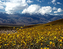
In spite of the overwhelming heat and sparse rainfall, Death Valley exhibits considerable biodiversity. Flowers, watered by snowmelt, carpet the desert floor each spring, continuing into June. [33] Bighorn sheep, red-tailed hawks, and wild donkeys may be seen. Death Valley has over 600 springs and ponds. Salt Creek, a mile-long shallow depression in the center of the valley, supports Death Valley Pupfish. [39] These isolated pupfish populations are remnants of the wetter Pleistocene climate. [39]

Darwin Falls, on the western edge of Death Valley Monument, falls 100 feet (30 m) into a large pond surrounded by willows and cottonwood trees. Over 80 species of birds have been recorded around the pond. [40]

Efflorescence, also known as salt flowers, is a rare occurrence in Death Valley that occurs when rain soaks into the soil and dissolves salt beneath the surface causing the ground to appear as if there is a light dusting of snow. [41]

History

Death Valley is home to the Timbisha tribe of Native Americans, formerly known as the Panamint Shoshone, who have inhabited the valley for at least the past millennium. The Timbisha name for the valley, tümpisa, means "rock paint" and refers to the red ocher paint that can be made from a type of clay found in the valley. Some families still live in the valley at Furnace Creek. Another village was in Grapevine Canyon near the present site of Scotty's Castle. It was called maahunu in the Timbisha language, whose meaning is uncertain, although it is known that hunu means 'canyon'. [42]

The valley received its English name in 1849 during the California Gold Rush. It was called Death Valley by prospectors [43] and others who sought to cross the valley on their way to the gold fields, after 13 pioneers perished from one early expedition of wagon trains. [44] [45] During the 1850s, gold and silver were extracted in the valley. In the 1880s, borax was discovered and extracted by mule-drawn wagons.

Zbriskie Point South Panorama 2012.jpg
Badlands at Zabriskie Point in Death Valley

Death Valley National Monument was proclaimed on February 11, 1933, by President Herbert Hoover, placing the area under federal protection. In 1994, the monument was redesignated as Death Valley National Park, as well as being substantially expanded to include Saline and Eureka Valleys.

Notable attractions and locations

Flash flood near Panamint Butte, Death Valley, in 2013 Death Valley exit SR190 view Panamint Butt flash flood 2013.jpg
Flash flood near Panamint Butte, Death Valley, in 2013

Films

A number of movies have been filmed in Death Valley, including: [46] [47]

Music

Television

See also

Notes

  1. Mean maxima and minima (i.e. the highest and lowest temperature readings during an entire month or year) calculated based on data at said location from 1991 to 2020.

Related Research Articles

<span class="mw-page-title-main">Death Valley National Park</span> National park in California and Nevada, United States

Death Valley National Park is an American national park that straddles the California–Nevada border, east of the Sierra Nevada. The park boundaries include Death Valley, the northern section of Panamint Valley, the southern section of Eureka Valley and most of Saline Valley.

<span class="mw-page-title-main">Inyo County, California</span> County in California, United States

Inyo County is a county in the eastern central part of the U.S. state of California, located between the Sierra Nevada and the state of Nevada. In the 2020 census, the population was 19,016. The county seat is Independence. Inyo County is on the east side of the Sierra Nevada and southeast of Yosemite National Park in Central California. It contains the Owens River Valley; it is flanked to the west by the Sierra Nevada and to the east by the White Mountains and the Inyo Mountains. With an area of 10,192 square miles (26,400 km2), Inyo is the second-largest county by area in California, after San Bernardino County. Almost one-half of that area is within Death Valley National Park. However, with a population density of 1.8 people per square mile, it also has the second-lowest population density in California, after Alpine County.

<span class="mw-page-title-main">Furnace Creek, California</span> Census-designated place in California, United States

Furnace Creek, formerly Greenland Ranch, is a census-designated place (CDP) in Inyo County, California, United States. The population was 136 at the 2020 census, up from 24 at the 2010 census. The elevation of the village is 190 feet (58 m) below sea level. The visitor center, museum, and headquarters of the Death Valley National Park are located at Furnace Creek.

<span class="mw-page-title-main">Desert climate</span> Arid climate subtype in the Köppen climate classification system with very little precipitation

The desert climate or arid climate is a dry climate sub-type in which there is a severe excess of evaporation over precipitation. The typically bald, rocky, or sandy surfaces in desert climates are dry and hold little moisture, quickly evaporating the already little rainfall they receive. Covering 14.2% of Earth's land area, hot deserts are the second most common type of climate on Earth after the polar climate.

<span class="mw-page-title-main">Stovepipe Wells, California</span> Unincorporated community in California, United States

Stovepipe Wells is a way-station in the northern part of Death Valley, in unincorporated Inyo County, California.

<span class="mw-page-title-main">Saline Valley</span> Valley in Mojave Desert, California

Saline Valley is a large, deep, and arid graben, about 27 miles (43 km) in length, in the northern Mojave Desert of California, a narrow, northwest–southeast-trending tectonic sink defined by fault-block mountains. Most of it became a part of Death Valley National Park when the park was expanded in 1994. This area had previously been administered by the Bureau of Land Management. It is located northwest of Death Valley proper, south of Eureka Valley, and east of the Owens Valley. The valley's lowest elevations are about 1,000 ft (300 m) and it lies in the rain shadow of the 14,000 ft (4,300 m) Sierra Nevada range, plus the 11,000 ft (3,400 m) Inyo Mountains bordering the valley on the west.

<span class="mw-page-title-main">Geology of the Death Valley area</span> Geology of the area in California and Nevada

The exposed geology of the Death Valley area presents a diverse and complex set of at least 23 formations of sedimentary units, two major gaps in the geologic record called unconformities, and at least one distinct set of related formations geologists call a group. The oldest rocks in the area that now includes Death Valley National Park are extensively metamorphosed by intense heat and pressure and are at least 1700 million years old. These rocks were intruded by a mass of granite 1400 Ma and later uplifted and exposed to nearly 500 million years of erosion.

<span class="mw-page-title-main">Places of interest in the Death Valley area</span>

Places of interest in the Death Valley area are mostly located within Death Valley National Park in eastern California.

The climate of Salt Lake City, Utah features cold and snowy winters, hot and dry summers, and modest to light seasonal rainfall. Lying in the Salt Lake Valley, the city is surrounded by mountains and the Great Salt Lake. Under the Köppen climate classification, Salt Lake City has either a Mediterranean climate (Csa) or dry-summer continental climate (Dsa) depending on which variant of the system is used, though it borders on a cold semi-arid climate (BSk) due to the city's relatively low precipitation.

<span class="mw-page-title-main">Badwater Ultramarathon</span> 135-mile run from Death Valley to the slopes of Mount Whitney

The Badwater Ultramarathon is a 135-mile (217 km) Ultramarathon race starting at −282 feet (−86 m) below sea level in the Badwater Basin, in California's Death Valley, and ending at an elevation of 8,360 feet (2,550 m) at Whitney Portal, the trailhead to Mount Whitney. It takes place annually in mid-July when the weather conditions are most extreme and temperatures can reach 130 °F (54 °C).

The Timbisha are a Native American tribe federally recognized as the Death Valley Timbisha Shoshone Band of California. They are known as the Timbisha Shoshone Tribe and are located in south central California, near the Nevada border. As of the 2010 Census the population of the Village was 124. The older members still speak the ancestral language, also called Timbisha.

<span class="mw-page-title-main">Oasis at Death Valley</span> Resort in California, US

The Oasis at Death Valley, formerly called Furnace Creek Inn and Ranch Resort, is a luxury resort in Furnace Creek, on private land within the boundaries of California's Death Valley National Park. It is owned and operated by Xanterra Travel Collection.

<span class="mw-page-title-main">Climate of California</span> Overview of the climate of the U.S. state of California

The climate of California varies widely from hot desert to alpine tundra, depending on latitude, elevation, and proximity to the Pacific Coast. California's coastal regions, the Sierra Nevada foothills, and much of the Central Valley have a Mediterranean climate, with warmer, drier weather in summer and cooler, wetter weather in winter. The influence of the ocean generally moderates temperature extremes, creating warmer winters and substantially cooler summers in coastal areas.

<span class="mw-page-title-main">Dante's View</span>

Dante's View is a viewpoint terrace at 1,669 m (5,476 ft) height, on the north side of Coffin Peak, along the crest of the Black Mountains, overlooking Death Valley. Dante's View is about 25 km (16 mi) south of Furnace Creek in Death Valley National Park.

<span class="mw-page-title-main">Climate of the United States</span> Varies due to changes in latitude, and a range of geographic features

The climate of the United States varies due to changes in latitude, and a range of geographic features, including mountains and deserts. Generally, on the mainland, the climate of the U.S. becomes warmer the further south one travels, and drier the further west, until one reaches the West Coast.

The highest temperature recorded on Earth has been measured in three major ways: air, ground, and via satellite observation. Air measurements are used as the standard measurement due to persistent issues with unreliable ground and satellite readings. Air measurements are noted by the World Meteorological Organization (WMO) and Guinness World Records among others as the standard to be used for determining the official record. The current official highest registered air temperature on Earth is 56.7 °C (134.1 °F), recorded on 10 July 1913 at Furnace Creek Ranch, in Death Valley in the United States. For ninety years, a former record that was measured in Libya had been in place, until it was decertified in 2012 based on evidence that it was an erroneous reading. This finding has since raised questions about the legitimacy of the 1913 record measured in Death Valley, with several meteorological experts asserting that there were similar irregularities. The WMO has stood by the record as official pending any future investigative results. If the current record were to be decertified then the holder would be a tie at 54.0 °C (129.2 °F), recorded both at Furnace Creek and in Kuwait.

<span class="mw-page-title-main">Lake Manly</span> Lake in Death Valley, California, United States

Lake Manly is a pluvial lake in Death Valley, California. It forms occasionally in Badwater Basin after heavy rainfall, but at its maximum extent during the so-called "Blackwelder stand," ending approximately 120,000 years before present, the lake covered much of Death Valley with a surface area of 1,600 square kilometres (620 sq mi). Water levels varied through its history, and the chronology is further complicated by active tectonic processes that have modified the elevations of the various shorelines of Lake Manly; during the Blackwelder stage they reached 47–90 metres (154–295 ft) above sea level. The lake received water mainly from the Amargosa River and at various points from the Mojave River and Owens River. The lake and its substantial catchment favoured the spread of a number of aquatic species, including some lizards, pupfish and springsnails. The lake probably supported a substantial ecosystem, and a number of diatoms developed there.

The 2018 North American heat wave affected regions of Canada, where at least 70 deaths in Quebec were heat-related, the United States, where 18 states between Michigan and New Mexico issued heat advisories to a population of over 60 million people, and of Mexico, particularly the northwest and central regions.

References

  1. 1 2 "USGS National Elevation Dataset (NED) 1 meter Downloadable Data Collection from The National Map 3D Elevation Program (3DEP) – National Geospatial Data Asset (NGDA) National Elevation Data Set (NED)". United States Geological Survey. September 21, 2015. Archived from the original on March 25, 2019. Retrieved September 22, 2015.
  2. "Feature Detail Report for: Death Valley". Geographic Names Information System . United States Geological Survey, United States Department of the Interior.
  3. "World Heat Record Overturned – A Personal Account". WunderBlog. Retrieved October 24, 2016. Consequently, the WMO assessment is that the official highest recorded surface temperature of 56.7°C (134°F) was measured on July 10, 1913 at Greenland Ranch (Death Valley) CA
  4. "Find Distance and Azimuths Between 2 Sets of Coordinates". Federal Communications Commission. Archived from the original on May 28, 2010. Retrieved August 13, 2010. Entered coordinates for Badwater 36-15-01-N, 116-49-33-W; and Mount Whitney 36-34-43-N, 118-17-31-W
  5. 1 2 "World Meteorological Organization World Weather / Climate Extremes Archive". Archived from the original on January 4, 2013. Retrieved April 14, 2017.
  6. 1 2 3 El Fadli, KI; et al. (September 2012). "World Meteorological Organization Assessment of the Purported World Record 58°C Temperature Extreme at El Azizia, Libya (13 September 1922)". Bulletin of the American Meteorological Society. 94 (2): 199. Bibcode:2013BAMS...94..199E. doi: 10.1175/BAMS-D-12-00093.1 .
  7. "'Highest temperature on Earth' recorded in US". BBC News. August 17, 2020. Retrieved August 17, 2020.
  8. Death Valley National Monument: Proposed Natural and Cultural Resources Management Plan and Draft Environmental Impact Statement. U.S. Department of the Interior. 1981. p. 72.
  9. Wright, JW, ed. (2006). The New York Times Almanac (2007 ed.). New York, New York: Penguin Books. p.  456. ISBN   0-14-303820-6.
  10. Cunningham, Bill; Cunningham, Polly (2016). Hiking Death Valley National Park. Rowman & Littlefield. p. 209.
  11. Sharp, RP; Glazner, AF (1997). Geology Underfoot in Death Valley and Owens Valley. Mountain Press Publishing. p. 195.
  12. "Image of the Day: Lake Badwater, Death Valley". Earth Observing System. NASA. March 18, 2009. Retrieved April 16, 2009.
  13. Celeste Cosby; Jeanette Hawkins; Jani Kushla; Molly Robinson (2009). "Boron Minerals of Death Valley". Clark Science Center, Smith College. Archived from the original on March 17, 2008.
  14. 1 2 Roof, Steven; Callagan, Charlie (2003). "The Climate of Death Valley, California" (PDF). Bulletin of the American Meteorological Society. 84 (12): 1725–1739. Bibcode:2003BAMS...84.1725R. doi:10.1175/bams-84-12-1725. Archived (PDF) from the original on April 21, 2019.
  15. Fischer, Barry (December 20, 2018). "Why is it colder at higher elevations? A thorough and visual explanation". Medium.
  16. "Death Valley Weather". US National Park Service.
  17. 1 2 3 "Weather and Climate". Death Valley National Park. U.S. National Park Service. May 23, 2008. Retrieved April 16, 2009.
  18. 1 2 National Park Service. "Weather and Climate" (PDF). Death Valley. NPS.gov. Archived (PDF) from the original on October 11, 2006. Retrieved May 29, 2009.
  19. Masters, Jeff. "Historic Heat Wave Reponsible[sic] for Death Valley's 129°F Gradually Weakening". WunderBlog. Wunderground. Archived from the original on November 5, 2013.
  20. Sumenow, Jason (October 25, 2016). "New analysis shreds claim that Death Valley recorded Earth's highest temperature in 1913". The Washington Post. Archived from the original on October 27, 2016.
  21. Graham Readfearn (August 17, 2020). "Death Valley temperature rises to 54.4C – possibly the hottest ever reliably recorded". The Guardian.
  22. "'Highest temperature on Earth' as Death Valley, US hits 54.4C". BBC News. August 17, 2020. Archived from the original on August 17, 2020. Retrieved July 30, 2021.
  23. NWS Las Vegas [@NWSVegas] (July 10, 2021). "DEATH VALLEY UPDATE Thermometer High temp at Death Valley today = 130F. Warning sign If this says anything about how hot SAT-SUN will be, HEED THESE WARNINGS. Do not put yourself, nor first responders in danger this weekend! This observed high temp is considered preliminary & not yet validated" (Tweet) via Twitter.
  24. "Death Valley, California, breaks the all-time world heat record for the second year in a row". yaleclimateconnections.org. Yale climate connections. July 12, 2021. Retrieved September 1, 2021.
  25. "Death Valley, California, breaks the all-time world heat record for the second year in a row". yaleclimateconnections.org. Yale climate connections. July 12, 2021. Retrieved September 1, 2021.
  26. WRCC. "Period of Record General Climate Summary – Temperature". Greenland Ranch, California. Desert Research Institute. Retrieved June 17, 2011.
  27. Kubecka, Paul (2001). "A possible world record maximum natural ground surface temperature". Weather. 56 (7): 218–221. Bibcode:2001Wthr...56..218K. doi:10.1002/j.1477-8696.2001.tb06577.x. S2CID   120698040.
  28. "July Daily Normals And Records" (PDF). The Death Valley Climate Book. National Weather Service. Archived (PDF) from the original on April 17, 2015. Retrieved March 26, 2017.
  29. Masters, Jeff (July 16, 2013). "Death Valley records a low of 107°F (41.7°C): a world record". Weather Underground. Archived from the original on May 7, 2013.
  30. Masters, Jeff (June 21, 2017). "A World Record Low Humidity? 116°F With a 0.36% Humidity in Iran by Dr. Jeff Masters | Category 6". Weather Underground . Retrieved June 10, 2018.
  31. Jeff Masters. "Death Valley records a low of 107°F (41.7°C): a world record". Blog. Weather Underground . Retrieved September 19, 2012.
  32. WRCC. "Monthly Climate Summary". Desert Research Institute. Retrieved June 8, 2009.
  33. 1 2 "Wet Winter Brings Life to Death Valley". NPR .
  34. "NOWData - NOAA Online Weather Data". National Oceanic and Atmospheric Administration . Retrieved October 11, 2021.
  35. "Summary of Monthly Normals 1991-2020". National Oceanic and Atmospheric Administration . Retrieved June 12, 2021.
  36. "Death Valley hits 127 degrees, setting record for hottest September day on the planet". CBS News. Retrieved September 2, 2022.
  37. "Cow Creek, California, Monthly Climate Summary, 1934–1961". Western Regional Climate Center, Desert Research Institute. Archived from the original on May 5, 2019. Retrieved June 8, 2019.
  38. Daley, Jason (2019). Flooding Creates a 10-Mile-Long Lake in Death Valley. Smithsonian Magazine. Retrieved June 29, 2020.
  39. 1 2 Lema, Sean (2008). "Phenotypic Plasticity of Death Valley's Pupfish". American Scientist .
  40. Kettmann, Matt; Grondahl, Paul; Watrous, Monica; Chase, Nan (May 2008). "Not So Dead". Smithsonian Magazine. p. 30.
  41. Hayley Smith (September 16, 2021). "Snow in Death Valley, the hottest place on Earth? It's not what it looks like". Los Angeles Times. Retrieved November 26, 2021.
  42. Jon P. Dayley, Tümpisa (Panamint) Shoshone Dictionary, University of California Publications in Linguistics Volume 116 (1989, University of California Press), page 89.
  43. Lingenfelter, Richard E.; Dwyer, Richard A. (1988). Death Valley Lore, Classic Tales of Fantasy, Adventure and Mystery. Reno: University of Nevada Press. ISBN   0-87417-136-9.
  44. Manly, William Lewis (1894). Death Valley in '49. The Pacific Tree and Vine Co. via Project Gutenberg.
  45. Reynolds, Jerry. "Paradise Found". Santa Clarita Valley Historical Society. Retrieved October 7, 2017.
  46. Schneider, Jerry L. (2016). Western Filming Locations California Book 6. Barnes & Noble. pp. 132–133. ISBN   978-1-9870-7242-6.
  47. "Death Valley in Movies and Television". National Park Service. April 2, 2022. Retrieved December 8, 2022.
  48. Hart, Hugh (August 29, 2011). "Cops Chase Zombies in MTV's Goofy Death Valley". Wired.