East County, San Diego

Last updated
East County
View of El Capitan from Santee's Sky Ranch .jpg
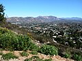
Santee, one of the four cities in East County
East County San Diego Map.png
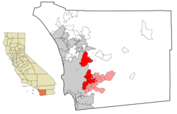
East County cities (red) and census-designated places (pink)
CountySan Diego County
Population
465,000

East County is a region of San Diego County, California, east of San Diego.

Contents

Geography

East County does not have an official geographic definition, although East County boundaries are unofficially drawn by the County of San Diego for its second district. [1] It commonly includes El Cajon, La Mesa, Lemon Grove, Poway, and Santee, as well as suburban and rural unincorporated communities such as Lakeside, Spring Valley, Jamul, and Alpine. Many sources also include vast swaths of the backcountry of San Diego County also known as the Mountain Empire, including communities along Interstate 8 such as Pine Valley and Descanso, and communities along the rural section of California State Route 94 such as Potrero, Boulevard, and Jacumba. [2] Other sources consider communities within the entire eastern two-thirds of the county to be East County, thereby encompassing places like Ramona, Julian, and Borrego Springs, [3] [4] The Ramona area—Ramona, San Diego Country Estates and Barona Mesa—is often considered part of inland North County due to its association with Rancho Bernardo, Escondido and other North County Inland communities. [5]

The populace of East County primarily dwells in the interior valleys east of San Diego proper while some development encroaches on the coastal foothills.

A broader definition of East County exists that includes the Cuyamaca Mountains and the Laguna Mountains, as well as the desert area of Anza-Borrego State Park. [6] Yet, this definition, when used by SANDAG, excludes the East Suburban centers. [7]

Prominent geologic formations include El Cajon Mountain, a large, dome-shaped mountain overlooking Santee and Lakeside, as well as Iron Mountain and Mount Woodson that overlook Poway.

Demographics

East County is the fourth most populous region in the San Diego metropolitan area, though its population is close to that of South Bay.

Populated places

Populations listed are from the 2020 census:

Incorporated cities

Census-designated places

Other unincorporated communities

Former communities

Education

Primary and secondary schools

East County is served by Santee School District, Grossmont Union High School District, Cajon Valley Union School District, Lakeside Union School District, Lemon Grove School District, Poway Unified School District.

Higher education

Grossmont College, located in El Cajon, and Cuyamaca College, located in Rancho San Diego, are two community colleges in the East County region. San Diego Christian College is located in Santee.

Landmarks

Important landmarks in East County included El Capitan, Mt. Helix, Santee Lakes, Sweetwater Reservoir, Poway's Tony Gwynn Statue, Lake Poway, and Lake Cuyamaca.

See also

Related Research Articles

<span class="mw-page-title-main">El Cajon, California</span> City in the state of California, United States

El Cajon is a city in San Diego County, California, United States, 17 mi (27 km) east of downtown San Diego. The city takes its name from Rancho El Cajón, which was named for the box-like shape of the valley that surrounds the city, and the origin of the city's common nickname "the Box".

<span class="mw-page-title-main">Santee, California</span> City in California, United States

Santee is a suburban city in San Diego County, California, with a population of 60,037 at the 2020 census. Although it is a part of the East County region, Santee is located just 18 miles (29 km) from the Pacific Ocean. The city is connected to the coastline by State Route 52, a six-lane freeway that runs from Interstate 5 in La Jolla to State Route 67 in El Cajon. The city is bisected by the San Diego River, a linear greenbelt that includes parks, trails and more than 1,100 acres (450 ha) of natural riparian habitat.

<span class="mw-page-title-main">San Diego County Sheriff's Department</span> Law enforcement agency in California, United States

The San Diego County Sheriff's Department (SDSD), is the primary and largest law enforcement agency in San Diego County, California, and one of the largest sheriff's departments in the United States: with over 4,000 employees, an annual budget of over $960 million, and a service area over 4,500 square miles extending to a 60-mile international border. The department, established in 1850, has over 4,000 sworn deputies and additional civilian support personnel servicing an area of nearly 4,526 mi².

<span class="mw-page-title-main">California State Route 67</span> Highway in California

State Route 67 (SR 67) is a state highway in San Diego County, California, United States. It begins at Interstate 8 (I-8) in El Cajon and continues to Lakeside as the San Vicente Freeway before becoming an undivided highway through the eastern part of Poway. In the town of Ramona, the route turns into Main Street before ending at SR 78. SR 67 provides direct access from the city of San Diego to the East County region of San Diego County, including Ramona and Julian.

<span class="mw-page-title-main">Area codes 619 and 858</span> Area codes for San Diego County, California

Area codes 619 and 858 are telephone area codes in the North American Numbering Plan (NANP) for most of San Diego County in the U.S. state of California. Area code 619 was created by a split of area code 714 in 1982. In 1999, a part of the 619 numbering plan area was assigned area code 858 in northwest San Diego County. In 2019, the area code boundary between 619 and 858 was eliminated, creating an overlay complex with the two area codes.

<span class="mw-page-title-main">Grossmont Union High School District</span> School district in California

The Grossmont Union High School District (GUHSD) is a public school district located in eastern San Diego County, California, and serves high school, adult school, and Regional Occupational Program (ROP) students in the cities of El Cajon, Lemon Grove, and Santee; the unincorporated communities of Alpine, Casa de Oro, Crest, Dehesa, Dulzura, Jamul, Lakeside, Mount Helix, Rancho San Diego, and Spring Valley; most of La Mesa, and parts of San Diego.

The San Diego County Library is a public library system serving San Diego County in the U.S. state of California. Any person living in the state is eligible for a free library card. The San Diego County Library consists of 33 branches, two bookmobiles, and two 24/7 Library to Go kiosks. Library Journal and Gale conferred the 2012 Library of the Year award on the San Diego County Library.

California's 48th congressional district is a congressional district in the U.S. state of California based in San Diego County in Southern California. It is currently represented by Republican Darrell Issa.

<span class="mw-page-title-main">San Diego-Imperial Council</span>

The San Diego-Imperial Council is headquartered in San Diego, California, and serves youth members and volunteer leaders through Scout units in San Diego and Imperial counties of Southern California, as well as a portion of Arizona.

California's 50th congressional district is a congressional district in the U.S. state of California, and encompasses parts of the Mid-Coast and northeastern parts of San Diego County. Scott Peters is currently the U.S. representative for California's 50th congressional district.

Grossmont College is a public community college in El Cajon, California. Its name originated with the silent film actor and producer William J. Gross, who was enticed by Ed Fletcher to invest in the purchase of land, part of which was called Grossmont. The campus sits in the Fletcher Hills community of El Cajon and is bordered by the cities of San Diego and Santee. Grossmont College along with Cuyamaca College make up what is the Grossmont-Cuyamaca Community College District. Grossmont is part of the California Community College System.

California's 52nd congressional district is a congressional district in the U.S. state of California. The district is currently represented by Democrat Juan Vargas.

<span class="mw-page-title-main">Cuyamaca Mountains</span> Mountain range of the Peninsular Ranges System, in San Diego County, southern California

The Cuyamaca Mountains, locally the Cuyamacas, are a mountain range of the Peninsular Ranges System, in San Diego County, southern California. The mountain range runs roughly northwest to southeast. The Laguna Mountains are directly adjacent to the east, with Palomar Mountain and Hot Springs Mountain more distant to the north.

<span class="mw-page-title-main">Grossmont–Cuyamaca Community College District</span>

The Grossmont–Cuyamaca Community College District is a California community college district comprising two colleges, Grossmont College and Cuyamaca College that serve about 28,000 students a year. Grossmont College is located in El Cajon, California and Cuyamaca College is located in Rancho San Diego, California, and primarily serves East San Diego and East County communities.

There are 34 routes assigned to the "S" zone of the California Route Marker Program, which designates county routes in California. The "S" zone includes county highways in Imperial, Orange, Riverside, San Diego, and Santa Barbara counties.

<span class="mw-page-title-main">San Diego County, California</span> County in California, United States

San Diego County, officially the County of San Diego, is a county in the southwestern corner of the U.S. state of California. As of the 2020 census, the population was 3,298,634, making it California's second-most populous county and the fifth-most populous in the United States. Its county seat is San Diego, the second-most populous city in California and the eighth-most populous city in the United States. It is the southwesternmost county in the 48 contiguous United States, and is a border county. It is also home to 18 Native American tribal reservations, the most of any county in the United States.

<span class="mw-page-title-main">Nestor, San Diego</span> Community of San Diego in California

Nestor is a residential neighborhood in the southern section of San Diego, and part of the Otay Mesa-Nestor community planning area. It neighbors Palm City and Otay Mesa West to the east, Egger Highlands to the north, San Ysidro to the southeast and the Tijuana River Valley to the south. Major thoroughfares include Coronado Avenue, Saturn Boulevard, Hollister Street, and Tocayo Avenue.

The Regions of the San Diego metropolitan area and San Diego County, as they cover the same area are:

References

  1. See, e.g., District 2 Boundaries
  2. See, e.g., East County Magazine neighborhoods, . Retrieved 19 March 2011.
  3. See, e.g., Mellin, Maribeth, and Onstott, Jane. Insider's Guide to San Diego. 5th ed. Morris Book Publishing. 2010. p. 8
  4. See also Vaughn, Jacqueline, and Cortner, Hanna J. Funding Fire: A Losing Proposition? The California Journal of Politics and Policy. Vol. 2, Issue 1. 2010. p.10.
  5. North County Times: Coastal and Inland cities
  6. Mellin, Maribeth, and Onstott, Jane. Insider's Guide to San Diego. 5th ed. Morris Book Publishing. 2010. p. 8
  7. "MSA: East Suburban" . Retrieved April 10, 2011.