La Joya is a city in Baja California also known as "La Gloria" in the Tijuana Municipality. The city had a population of 30,063 as of 2018. [1] Its urban area links Tijuana with Rosarito Beach.

La Joya is a city in Baja California also known as "La Gloria" in the Tijuana Municipality. The city had a population of 30,063 as of 2018. [1] Its urban area links Tijuana with Rosarito Beach.

Imperial Beach is a residential beach city in San Diego County, California, with a population of 26,324 at the 2010 census. The city is the southernmost city in California and the West Coast of the United States. It is in the South Bay area of San Diego County, 14.1 miles (22.7 km) south of downtown San Diego and 5 miles (8 km) northwest of downtown Tijuana, Mexico.

The Coronado Islands are a group of four islands off the northwest coast of the Mexican state of Baja California. Battered by the wind and waves, they are largely barren and uninhabited except for a small military detachment and a few lighthouse keepers. The islands lie between 15 and 19 miles south of the entrance to San Diego bay, but only 8 miles from the Mexican mainland. They share their name with the tied island city of Coronado, California, which separates San Diego Bay from the Pacific Ocean, on the other side of the United States-Mexico border.

Federal Highway 1 is a free (libre) part of the federal highway corridors of Mexico, and the highway follows the length of the Baja California Peninsula from Tijuana, Baja California, in the north to Cabo San Lucas, Baja California Sur, in the south. The road connects with Via Rapida, which merges into the American Interstate 5 (I-5) at the San Ysidro Port of Entry, which crosses the international border south of San Ysidro, California.

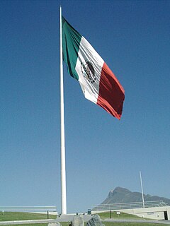
The banderas monumentales are a collection of tall flagpoles containing large flags of Mexico located throughout Mexico. They are part of a program started in 1999 under President Ernesto Zedillo that is currently administered by the Secretariat of National Defense. The main feature of these monuments is a giant Mexican flag flying off a 50-meter-high (160-ft) flagpole. The size of the flag was 14.3 by 25 metres and it was flown on a pole that measured 50 metres (160 ft) high. In the time after the decree was issued, many more banderas monumentales have been installed throughout the country in various sizes. Many of the locations were chosen due to significant events in Mexican history that occurred there.

San Diego–Tijuana is an international transborder agglomeration, straddling the border of the adjacent North American coastal cities of San Diego, California, United States and Tijuana, Baja California, Mexico. The 2012 population of the region was 4,922,723, making it the largest bi-national conurbation shared between the United States and Mexico, the second-largest shared between the US and another country. In its entirety, the region consists of San Diego County in the United States and the municipalities of Tijuana, Rosarito Beach, and Tecate in Mexico. It is the third most populous region in the California–Baja California region, smaller only than the metropolitan areas of Greater Los Angeles and the San Francisco Bay Area.

The Roman Catholic Archdiocese of Tijuana is a Metropolitan Archdiocese in Mexico. It is based in the city of Tijuana, Baja California, and the province has the suffragan dioceses of Ensenada, La Paz en la Baja California Sur, and Mexicali.
The Tijuana Cultural Center (CECUT) is a cultural center in the Zona Río district of Tijuana, Mexico. The center opened 20 October 1982, and accommodates more than a million visitors per year.

Hospital Angeles Tijuana is a skyscraper and prominent fixture in Tijuana, Mexico. It serves as the primary hospital of Tijuana. The building includes office space as well as the main hospital which is located within a complex composed of another building, a 5-story tower, which on its roof has a heliport, being the first hospital in the city with such a feature.
The following radio stations broadcast on AM frequency 690 kHz: 690 AM is a Canadian and Mexican clear-channel frequency. CKGM Montreal and XEWW Tijuana share Class A status of 690 kHz.
The following radio stations broadcast on AM frequency 1090 kHz: 1090 AM is a United States and Mexican clear-channel frequency. KAAY Little Rock, WBAL Baltimore and XEPRS-AM Rosarito-Tijuana share Class A status on 1090 AM.

The Plaza Monumental de Tijuana, and popularly known in English as the Bullring by the Sea, is a bullring in the city of Tijuana, Baja California, Mexico. It is currently used for bullfighting; the bullring has also been the scene for great boxing matches, concerts, cultural, and sporting events that have benefited the Tijuana community greatly. The stadium holds 21,621 people and its opening was held on June 26, 1960. It is located just 60 meters from the United States border and one block from the Pacific Ocean.

Tijuana River National Estuarine Research Reserve is a natural reserve in Imperial Beach, California and San Ysidro, San Diego. It encompasses the Tijuana River Estuary, located on the Mexico–United States border. It is divided into two parts: the Tijuana Slough National Wildlife Refuge on the north, and Border Field State Park in the south.

Nestor is a residential neighborhood in the southern section of San Diego, and part of the Otay Mesa-Nestor community planning area. It neighbors Palm City and Otay Mesa West to the east, Egger Highlands to the north, San Ysidro to the southeast and the Tijuana River Valley to the south. Major thoroughfares include Coronado Avenue, Saturn Boulevard, Hollister Street, and Tocayo Avenue.
The Tijuana River Valley is a rural community in the southern section of San Diego, California. It neighbors Imperial Beach to the north and west, Egger Highlands and Nestor to the north, San Ysidro to the east, and the U.S.-Mexico border to the south. Major thoroughfares include Hollister Street, Monument Road, and Dairy Mart Road.
The International Wastewater Treatment Plant (IWTP) is a plant developed by the International Boundary and Water Commission (IBWC) in the South Bay area of San Diego, California. Construction began on a 75-acre site, west of San Ysidro in the Tijuana River Valley. The project, authorized by the U.S. Congress in 1989 and formally agreed between the two countries in July 1990, was part of a regional approach to solve long-standing problems, particularly the flow of sewage-contaminated water into the ocean via the Tijuana River.
Pórticos de San Antonio, or San Antonio Heights, is a fraccionamiento in Baja California in Tijuana Municipality. The city had a population of 34,234 as of 2010.
Tijuana River Mouth State Marine Conservation Area (SMCA) is a marine protected area that extends offshore of southern San Diego County on California’s south coast. The SMCA covers 2.91 square miles.

Dorian's was a department store chain based in Tijuana, Baja California, Mexico.
The following is a timeline of the history of the city of Tijuana, Baja California, Mexico.
Rancho Melijo, or Milijo, named after a local Kumeyaay village. It was later called Rancho La Punta for the location of the Arguello family ranch house, on a point of hills overlooking the south end of San Diego Bay, north of the Otay River and east of where the river entered the south bend of the bay. It was a Mexican land grant rancho, granted by Governor José Figueroa in 1833 to Santiago E. Argüello.
Coordinates: 32°26′44″N117°00′11″W / 32.44556°N 117.00306°W