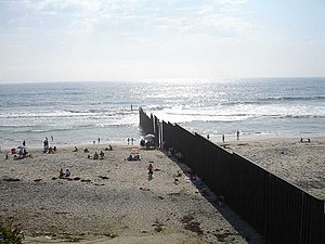
Tijuana is the most populous city in the state of Baja California, located on the northwestern Pacific Coast of Mexico. Tijuana is the municipal seat of the Tijuana Municipality and the hub of the Tijuana metropolitan area. It has a close proximity to the Mexico–United States border, which is part of the San Diego–Tijuana metro area.
Baja California, officially the Free and Sovereign State of Baja California, is a state in Mexico. It is the northwesternmost of the 32 federal entities of Mexico. Before becoming a state in 1952, the area was known as the North Territory of Baja California. It has an area of 70,113 km2 (27,071 sq mi) and comprises the northern half of the Baja California peninsula, north of the 28th parallel, plus oceanic Guadalupe Island. The mainland portion of the state is bordered on the west by the Pacific Ocean; on the east by Sonora, the U.S. state of Arizona, and the Gulf of California; on the north by the U.S. state of California; and on the south by Baja California Sur.

Mexicali is the capital city of the Mexican state of Baja California. The city, which is the seat of the Mexicali Municipality, has a population of 689,775, according to the 2010 census, while the Calexico–Mexicali metropolitan area is home to 1,000,000 inhabitants on both sides of the Mexico–United States border. Mexicali is a regional economic and cultural hub for the border region of The Californias.

Rosarito is a coastal city in Playas de Rosarito Municipality, Baja California, on the Pacific Coast of Mexico. As of 2010, the city had a population of 65,278. Located 10 miles (16 km) south of the US–Mexico border, Rosarito is a part of the greater San Diego–Tijuana region and one of the westernmost cities in Mexico. Rosarito is a major tourist destination, known for its beaches, resorts, and events like Baja Beach Fest.
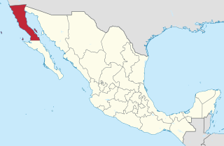
Baja California is a state in Northwest Mexico that is divided into seven municipalities. According to the 2020 Mexican census, Baja California is the 13th most populous state with 3,769,020 inhabitants and the 12th largest by land area spanning 73,290.08 square kilometres (28,297.46 sq mi).

Ensenada is a municipality in the Mexican state of Baja California. It is the fourth-largest municipality in the country, with a land area of 19,526.8 km2 (7,539.3 sq mi) in 2020, making slightly smaller than the state of Hidalgo and larger than five other Mexican states.

Mexicali Municipality is a municipality in the Mexican state of Baja California. Its municipal seat is located in the city of Mexicali. As of 2020, the municipality had a total population of 1,049,792. The municipality has an area of 13,700 km2 (5,300 sq mi). This includes many smaller outlying communities as well as the city of Mexicali. Also, the islands of Baja California located in the Gulf of California are part of the municipality, among them the mudflat islands at the mouth of the Colorado River, Isla Ángel de la Guarda and the islands of San Lorenzo Marine Archipelago National Park. Mexicali is the northernmost municipality of Latin America.

Tecate is a municipality in the Mexican state of Baja California. Its municipal seat is located in the city of Tecate. According to the 2020 census, it had a population of 108,440 inhabitants. The municipality has an area of 3,079.0 km².

Playas de Rosarito Municipality is located in the northwestern part of the Mexican state of Baja California comprising part of the Tijuana metropolitan area. It lies just south of the city of Tijuana. Its municipal seat is the city of Rosarito. According to the 2020 census, the municipality had a population of 126,890 inhabitants. Its area is 513.32 km2.

Almoloya de Juárez is a town in the State of Mexico and the seat of the municipality of Almoloya de Juárez. The name Almoloya comes from the Nahuatl, that is properly Almoloyan, composed of: atl, "water"; molo "impersonal voice of moloni, to flow the source" and yan, "place"; that it means "place where flows the water source".

Metropolitan areas of Mexico have been traditionally defined as the group of municipalities that heavily interact with each other, usually around a core city, in Mexico. The phenomenon of metropolization in Mexico is relatively recent, starting in the 1940s. Because of an accelerated level of urbanization in the country, the definition of a metropolitan area is reviewed periodically by the Mexican population and census authorities.
San Diego–Tijuana is an international transborder agglomeration, straddling the border of the adjacent North American coastal cities of San Diego, California, United States, and Tijuana, Baja California, Mexico. The 2020 population of the region was 5,456,577, making it the largest bi-national conurbation shared between the United States and Mexico, and the second-largest shared between the US and another country. The conurbation consists of San Diego County, in the United States and the municipalities of Tijuana, Rosarito Beach (126,980), and Tecate (108,440) in Mexico. It is the third most populous region in the California–Baja California region, smaller only than the metropolitan areas of Greater Los Angeles and the San Francisco Bay Area.
In Mexico, some municipalities and Mexico City are divided into “boroughs” for administrative purposes. Boroughs are known as delegaciones, or in the case of Mexico City, demarcaciones territoriales. Boroughs can either be second-level semi-autonomous administrative divisions or third-level non-autonomous administrative divisions. The limits, nature and competencies of boroughs are usually described in the constitutions of the states they are part of, or in the laws enacted by the municipality itself, and may differ from municipality to municipality.
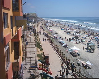
Playas de Tijuana is the westernmost borough of the municipality of Tijuana, Baja California, stretching from the United States border in the north to Rosarito Beach Municipality in the south. The Bullring by the Sea was opened in 1960.
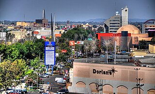
Zona Río is an official zone, and the main modern business district, of the city of Tijuana, Mexico.
Valle de las Palmas is located between two hamlets Espuela and Seco in the municipalities of Tijuana and Tecate, Baja California, Mexico. It is the site of a long-term planned urban development which would take advantage of proximity to the existing cities of Tijuana to the north west and Mexicali to the north east to create a similar sized city of one million people by the year 2030, on Mexican Federal Highway 3 around an existing industrial park and university campus Unidad Valle De Las Palmas. The first project in Valle de las Palmas, named Valle San Pedro, is proposed by the Mexican Federal Government, the State of Baja California, Urbi and Banobras. It has been certified as the first Integral Sustainable Urban Development or DUIS in Mexico, which establishes criteria in collaboration with Interamerican Development Bank IDB to evaluate projects that will receive inter-secretarial technical support and public investment. The locality reported a population of 1,860 inhabitants in the 2010 federal census. It is located at an altitude of 282 m. (925 ft.) above sea level. Also is an agricultural area with olives and grapes fields, and some farms with cows, porks and poultry.
The Tijuana metropolitan area, and in Spanish the Zona Metropolitana de Tijuana, is located by the Pacific Ocean in Mexico. The 2010 census placed the Tijuana metropolitan area as the fifth largest city by population in the country with 1,751,302 people. The census bureau defined metropolitan area comprises three municipalities: Tijuana, Tecate, and Rosarito Beach. Yet sources commonly include Tecate Municipality in the metropolitan area as the urban area between Tijuana and Tecate grows, the commuting populace increases - ultimately further developing the southern areas of San Diego–Tijuana, and the three municipalities maintain strong relationships and cooperation.
Otay Centenario is a borough of the municipality of Tijuana in Baja California, Mexico. It is the result of a merger between the former boroughs of Mesa de Otay and Centenario which took place on January 1, 2014.

The Autonomous University of Baja California, Tijuana is one of three main campuses of the Autonomous University of Baja California (UABC), located in the Otay Centenario borough of Tijuana, Baja California state, México. It is a public research university.