This article relies largely or entirely on a single source .(October 2019) |
Villa del Prado (Spanish for Town of the Meadow) is a city in Baja California in Tijuana Municipality. The city had a population of 12,303 as of 2010. [1]
This article relies largely or entirely on a single source .(October 2019) |
Villa del Prado (Spanish for Town of the Meadow) is a city in Baja California in Tijuana Municipality. The city had a population of 12,303 as of 2010. [1]

Federal Highway 1 is a free (libre) part of the federal highway corridors of Mexico, and the highway follows the length of the Baja California Peninsula from Tijuana, Baja California, in the north to Cabo San Lucas, Baja California Sur, in the south. The road connects with Via Rapida, which merges into the American Interstate 5 (I-5) at the San Ysidro Port of Entry, which crosses the international border south of San Ysidro, California.

Tijuana Municipality is a municipality in the Mexican state of Baja California. Its municipal seat is located in the city of Tijuana. According to the 2010 census, the municipality had a population of 1,559,683 inhabitants, of whom 1,300,983, or 83.4%, lived in the city of Tijuana. The municipality maintained its position as 3rd most populated nationally as of 2015 census, only behind Ecatepec de Morelos and Iztapalapa. Luis Arturo González Cruz of the MORENA is the current municipal president. The municipality comprises the largest part of the Tijuana metropolitan area.
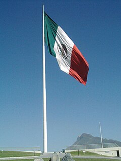
The banderas monumentales are a collection of tall flagpoles containing large flags of Mexico located throughout Mexico. They are part of a program started in 1999 under President Ernesto Zedillo that is currently administered by the Secretariat of National Defense. The main feature of these monuments is a giant Mexican flag flying off a 50-meter-high (160-ft) flagpole. The size of the flag was 14.3 by 25 metres and it was flown on a pole that measured 50 metres (160 ft) high. In the time after the decree was issued, many more banderas monumentales have been installed throughout the country in various sizes. Many of the locations were chosen due to significant events in Mexican history that occurred there.
Auditorio Fausto Gutierrez Moreno also known as Auditorio de Tijuana is an indoor arena in Tijuana, Mexico. It is primarily used for basketball and is the home field of the Tijuana Dragons and Galgos de Tijuana. It holds 4,500 people and was built in 1969.
The Agua Caliente Racetrack is a greyhound racing and former horse racing track in Tijuana, Baja California, Mexico. It opened in December 1929 at a cost of $2.5 million.
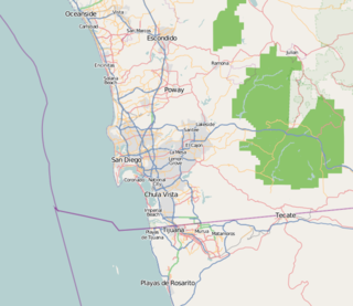
San Diego–Tijuana is an international transborder agglomeration, straddling the border of the adjacent North American coastal cities of San Diego, California, United States and Tijuana, Baja California, Mexico. The 2012 population of the region was 4,922,723, making it the largest bi-national conurbation shared between the United States and Mexico, the second-largest shared between the US and another country. In its entirety, the region consists of San Diego County in the United States and the municipalities of Tijuana, Rosarito Beach, and Tecate in Mexico. It is the third most populous region in the California–Baja California region, smaller only than the metropolitan areas of Greater Los Angeles and the San Francisco Bay Area.

La Salina Del Mar is a gringo community in the Mexican state of Baja California. It is located on the beach 73 km south of Tijuana at 32° 03´36" N 116° 52´ 42" W. La Salina is the home of Puerto Salina, the first marina in Mexico south of the United States border on the Pacific Ocean. The marina has 240 slips and can accommodate yachts as large as 100 feet in length. The annual gray whale migration path is approx 1 km off the coast and they can often be seen surfacing from the beach. La Salina Del Mar is also home of Puerto Cielo, Baja's most diverse airsport venue. Paraglider and hang glider pilots come from throughout North America to enjoy the coastal mountain ridge that offers a strong thermal and one of the most spectacular ocean views available to glider pilots.

Marina Puerto Salina is in the Mexican state of Baja California. It is located at 73 km south of Tijuana at 32° 3.28´N 116° 53.20´W. Puerto Salina is the first marina in Mexico south of the United States border on the Pacific Ocean. Puerto Salina is located next to La Salina, Baja California, 62 km (45 mi) south of San Diego Bay. The marina has more than 250 slips and can accommodate yachts as large as 100 feet in length.
La Mesa prison is a penitentiary in Tijuana, Baja California, Mexico, near the Mexico–United States border. It is located in the La Mesa section of the city.
Valle de las Palmas is located between two hamlets Espuela and Seco in the municipalities of Tijuana and Tecate, Baja California, Mexico. It is the site of a long-term planned urban development which would take advantage of proximity to the existing cities of Tijuana to the north west and Mexicali to the north east to create a similar sized city of one million people by the year 2030, on Mexican Federal Highway 3 around an existing industrial park and university campus Unidad Valle De Las Palmas. The first project in Valle de las Palmas, named Valle San Pedro, is proposed by the Mexican Federal Government, the State of Baja California, Urbi and Banobras. It has been certified as the first Integral Sustainable Urban Development or DUIS in Mexico, which establishes criteria in collaboration with Interamerican Development Bank IDB to evaluate projects that will receive inter-secretarial technical support and public investment. The locality reported a population of 1,860 inhabitants in the 2010 federal census. It is located at an altitude of 282 m. above sea level.

La Joya is a city in Baja California in the Tijuana Municipality. The city had a population of 30,063 as of 2018. Its urban area links Tijuana with Rosarito Beach.
Las Delicias is a city in Baja California in Tijuana Municipality, Mexico. The city had a population of 15,486 as of 2010.
Terrazas del Valle – Terraces of the Valley – is a city in Baja California in Tijuana Municipality. The city had a population of 20,421 as of 2010.
Pórticos de San Antonio, or San Antonio Heights, is a fraccionamiento in Baja California in Tijuana Municipality. The city had a population of 34,234 as of 2010.
Villa del Campo – Town of the Country – is a city in Baja California in Tijuana Municipality. The city had a population of 13,906 as of 2010.

The Tijuana Mexico Temple is a temple of The Church of Jesus Christ of Latter-day Saints in Tijuana, México. Completed in 2015, the intent to construct the temple was announced by church president Thomas S. Monson on October 2, 2010, during the church's semi-annual general conference. It is the thirteenth temple built in Mexico.
Rancho San Isidro Ajajolojol, also known as Rancho Joljol or Toljol or Rancho Jesus Maria or San Ysidro Ajajolojol, was a land grant made to José López in 1836 by interim Governor Nicolas Gutierrez.

Rio Alamar or Arroyo de Alamar is a river mainly in northern Baja California, Mexico with a small portion in California, United States. The stream is formed by the confluence of Cottonwood Creek and Tecate Creek a short distance north of the Mexico–United States border. It flows generally west for about 25 kilometres (16 mi) through the San Ysidro Mountains and the Tijuana urban area before joining with the Arroyo de las Palmas in central Tijuana, to form the Tijuana River.
Tecate Creek is a stream in northern Baja California, Mexico with its headwaters in southern San Diego County, California in the United States. It begins along the Tecate Divide in the In-Ko-Pah Mountains, near Live Oak Springs. The upper reaches of the stream in the US are known as Campo Creek. It flows southwest, crossing the Mexico–United States border at Canyon City, before flowing through the city of Tecate, Baja California. West of Tecate it flows through a gorge and briefly re-enters the US where it combines with Cottonwood Creek to form the Rio Alamar, a tributary of the Tijuana River which it joins in Central Tijuana.

La Cinco y Diez, is the name of an intersection, pedestrian overpass over that intersection, public transportation hub and major retail district in La Mesa borough, Tijuana, Mexico. The name exists because a branch of the Luján/Cardenas family's "La Cinco y Diez" five and dime store once stood here, and Tijuana residents taking taxis or buses would ask to be let off by "La Cinco y Diez".
| Counties and Municipalities |  | |
|---|---|---|
| Major cities | ||
| Cities 100k - 250k | ||
| Cities and towns 20k - 99k | ||
| Cities and towns 10k-19k | ||
| Bodies of water | ||
| Sub-regions | ||
Coordinates: 32°24′30″N116°57′58″W / 32.40833°N 116.96611°W
| | This article about a location in the Mexican state of Baja California is a stub. You can help Wikipedia by expanding it. |