
An estuary is a partially enclosed coastal body of brackish water with one or more rivers or streams flowing into it, and with a free connection to the open sea. Estuaries form a transition zone between river environments and maritime environments and are an example of an ecotone. Estuaries are subject both to marine influences such as tides, waves, and the influx of saline water, and to fluvial influences such as flows of freshwater and sediment. The mixing of seawater and freshwater provides high levels of nutrients both in the water column and in sediment, making estuaries among the most productive natural habitats in the world.

In ecology, a marsh is a wetland that is dominated by herbaceous plants rather than by woody plants. More in general, the word can be used for any low-lying and seasonally waterlogged terrain. In Europe and in agricultural literature low-lying meadows that require draining and embanked polderlands are also referred to as marshes or marshland.

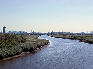
Long Island Sound is a marine sound and tidal estuary of the Atlantic Ocean. It lies predominantly between the U.S. state of Connecticut to the north and Long Island in New York to the south. From west to east, the sound stretches 110 mi (180 km) from the East River and the Throgs Neck Bridge in New York City, along the North Shore of Long Island, to Block Island Sound. A mix of freshwater from tributaries, and saltwater from the Atlantic Ocean, Long Island Sound is 21 mi (34 km) at its widest point and varies in depth from 65 to 230 feet.
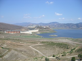
The Tijuana River is an intermittent river, 120 mi (195 km) long, near the Pacific coast of northern Baja California state in northwestern Mexico and Southern California in the western United States. The river is heavily polluted with raw sewage from the city of Tijuana, Mexico.
Berry's Creek is a tributary of the Hackensack River in the New Jersey Meadowlands in Bergen County, New Jersey. The creek watershed contains a diverse array of wetlands, marshes, and wildlife. The creek runs through a densely populated region and has been subject to extensive industrial pollution during the 19th and 20th centuries. Several companies discharged toxic chemicals into the creek in the 20th century, and these chemicals have remained in the sediment. The creek has the highest concentrations of methyl mercury of any freshwater sediment in the world. Portions of the creek watershed are Superfund sites, and cleanup projects began in the late 20th century.

Ashtamudi Lake, in the Kollam District of the Indian state of Kerala is a unique wetland ecosystem and a large palm-shaped water body. It is second only in size to the Vembanad estuary ecosystem of the state. Ashtamudi means 'eight hills or peaks' in the local Malayalam language. The name is indicative of the lake's topography with its multiple branches. The lake is also called the gateway to the backwaters of Kerala and is well known for its houseboat and backwater resorts. Ashtamudi Wetland was included in the list of wetlands of international importance, as defined by the Ramsar Convention for the conservation and sustainable utilization of wetlands. Ashtamudi Estuary is the deepest among all the estuaries in Kerala, with a maximum depth of 6.4 meters at the confluence zone.
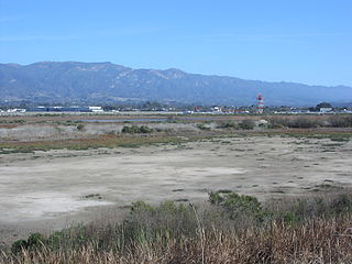
The Goleta Slough is an area of estuary, tidal creeks, tidal marsh, and wetlands near Goleta, California, United States. It primarily consists of the filled and unfilled remnants of the historic inner Goleta Bay about 8 miles (13 km) west of Santa Barbara. The slough empties into the Pacific Ocean through an intermittently closed mouth at Goleta Beach County Park just east of the UCSB campus and Isla Vista. The slough drains the Goleta Valley and watershed, and receives the water of all of the major creeks in the Goleta area including the southern face of the Santa Ynez Mountains.

Ballona Wetlands Ecological Reserve is a protected area that once served as the natural estuary for neighboring Ballona Creek. The 577-acre (2.34 km2) site is located in Los Angeles County, California, just south of Marina del Rey. Ballona—the second-largest open space within the city limits of Los Angeles, behind Griffith Park—is owned by the state of California and managed by the California Department of Fish and Wildlife. The preserve is bisected generally east-west by the Ballona Creek channel and bordered by the 90 Marina freeway to the east.

Arcata Wastewater Treatment Plant and Wildlife Sanctuary is an innovative sewer management system employed by the city of Arcata, California.

Ridgway's rail is a species of bird found principally along the Pacific coast of North America from the San Francisco Bay Area to southern Baja California, as well as in some regions of the Gulf of California. A member of the rail family, Rallidae, it is a chicken-sized bird that lives brackish tidal marshes and rarely flies. Its name commemorates American ornithologist Robert Ridgway.

The Pacific Flyway is a major north-south flyway for migratory birds in the Americas, extending from Alaska to Patagonia. Every year, migratory birds travel some or all of this distance both in spring and in fall, following food sources, heading to breeding grounds, or travelling to overwintering sites.

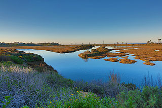
Elkhorn Slough is a 7-mile-long (11 km) tidal slough and estuary on Monterey Bay in Monterey County, California. It is California's second largest estuary and the United States' first estuarine sanctuary. The community of Moss Landing and the Moss Landing Power Plant are located at the mouth of the slough on the bay.

Freshwater biology is the scientific biological study of freshwater ecosystems and is a branch of limnology. This field seeks to understand the relationships between living organisms in their physical environment. These physical environments may include rivers, lakes, streams, ponds, reservoirs, or wetlands. Knowledge from this discipline is also widely used in industrial processes to make use of biological processes involved with sewage treatment and water purification. Water presence and flow is an essential aspect to species distribution and influences when and where species interact in freshwater environments.

The Mobile–Tensaw River Delta is the largest river delta and wetland in Alabama. It encompasses approximately 260,000 acres (110,000 ha) in a 40-by-10-mile area and is the second largest delta in the contiguous United States. This large river delta is approximately 45 miles long and averages 8 miles wide, being 16 miles wide at its widest point. It covers approximately 300 square miles. Of its 260,000 acres, 20,000 acres consist of open water, 10,000 acres of marsh, 70,000 acres of swamp; and more than 85,000 acres of bottomland forest. It drains an area of about 44,000 sq miles, which includes 64% of Alabama and small portions of Georgia and Mississippi.
San Elijo Lagoon Ecological Reserve is one of the largest remaining coastal wetlands in San Diego County, California, United States.

Tijuana River National Estuarine Research Reserve is a natural reserve in Imperial Beach, California, and San Ysidro, San Diego. It encompasses the Tijuana River Estuary, located on the Mexico–United States border. It is divided into two parts: Tijuana Slough National Wildlife Refuge on the north, and Border Field State Park in the south.
Pass a Loutre Wildlife Management Area (WMA) is a 115,000-acre (47,000 ha) protected wetland in Plaquemines Parish, Louisiana, United States. The WMA is located due south and bordering the 48,000 acre Delta National Wildlife Refuge, accessible only by air or boat, contains the Pass A L'Outre Lighthouse, and Port Eads is within the boundary.

Hingol National Park or Hungol National Park is one of the largest national parks in Pakistan, located in the Makran coastal region. The park covers an area of about 6,100 square kilometres (2,400 sq mi) and is located 190 km from Karachi in the three districts of Gwadar, Lasbela and Awaran in Balochistan. Hingol was declared a national park in 1988.
The San Diego National Wildlife Refuge Complex is a series of wildlife refuges established by the United States National Wildlife Service beginning in 1972. The complex incorporates five refuges in San Diego County and Orange County in California.

Goat Canyon also known as Cañón de los Laureles, begins in Tijuana, Mexico, and ends in the United States just north of the Mexico–U.S. border. The canyon is formed by Goat Canyon Creek, which receives water and other runoff from areas south of the border. Most of the canyon and its watershed lies within Baja California.


