
The Sacramento River is the principal river of Northern California in the United States and is the largest river in California. Rising in the Klamath Mountains, the river flows south for 400 miles (640 km) before reaching the Sacramento–San Joaquin River Delta and San Francisco Bay. The river drains about 26,500 square miles (69,000 km2) in 19 California counties, mostly within the fertile agricultural region bounded by the Coast Ranges and Sierra Nevada known as the Sacramento Valley, but also extending as far as the volcanic plateaus of Northeastern California. Historically, its watershed has reached as far north as south-central Oregon where the now, primarily, endorheic (closed) Goose Lake rarely experiences southerly outflow into the Pit River, the most northerly tributary of the Sacramento.

San Pablo Bay is a tidal estuary that forms the northern extension of the San Francisco Bay in the East Bay and North Bay regions of the San Francisco Bay Area in northern California.

The Yolo Bypass is one of the two flood bypasses in California's Sacramento Valley located in Yolo and Solano Counties. Through a system of weirs, the bypass diverts floodwaters from the Sacramento River away from the state's capital city of Sacramento and other nearby riverside communities.

Don Edwards San Francisco Bay National Wildlife Refuge (DESFBNWR) is a United States National Wildlife Refuge located in the southern part of San Francisco Bay, California. Its headquarters and visitor center are in the Baylands district of Fremont, next to Coyote Hills Regional Park, in Alameda County. The visitor center is on Marshlands Rd, off Thornton Ave.

The Klamath Project is a water-management project developed by the United States Bureau of Reclamation to supply farmers with irrigation water and farmland in the Klamath Basin. The project also supplies water to the Tule Lake National Wildlife Refuge, and the Lower Klamath National Wildlife Refuge. The project was one of the first to be developed by the Reclamation Service, which later became the Bureau of Reclamation.

The Klamath Basin National Wildlife Refuge Complex is a wildlife preserve operated by the United States Fish and Wildlife Service in the Klamath Basin of southern Oregon and northern California near Klamath Falls, Oregon. It consists of Bear Valley, Klamath Marsh and Upper Klamath National Wildlife Refuge (NWR) in southern Oregon and Lower Klamath, Tule Lake, and Clear Lake NWR in northern California.

The Lower Klamath National Wildlife Refuge is a National Wildlife Refuge of the United States on the border between California and Oregon. It is operated by the United States Fish and Wildlife Service. The refuge was designated a National Historic Landmark on October 16, 1965.

The Tule Lake National Wildlife Refuge is a National Wildlife Refuge of the United States in northern California near the Oregon border. It covers 39,116 acres (15,830 ha) in the Tule Lake basin. It is part of the Klamath Basin National Wildlife Refuge Complex, and is a crucial part of the Pacific Flyway corridor for migratory birds.
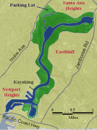
The Upper Newport Bay is a large coastal wetland in Newport Beach, Southern California and a major stopover for birds on the Pacific Flyway. Dozens of species, including endangered ones, can be observed here. Upper Newport Bay Nature Preserve and Ecological Reserve represent approximately 1,000 acres (4 km2) of open space. The Upper Newport Bay was purchased by the state in 1975 for its Fish and Wildlife Department's Ecological Reserve System. In 1985 the upper west bluffs and lands surrounding the bay became part of an Orange County regional park, which offers outdoor activities such as bird-watching, jogging, bicycling, hiking, and kayaking. The Peter and Mary Muth Interpretive Center, located at 2301 University Drive, is open to the public Tuesday through Sunday from 10:00 AM to 4:00 PM. An organization known as the Newport Bay Conservancy (NBC) provides volunteers to answer visitors' questions and guide them through the various activities.

The Atlantic Flyway is a major north-south flyway for migratory birds in North America. The route generally starts in Greenland, then follows the Atlantic coast of Canada, then south down the Atlantic Coast of the United States to the tropical areas of South America and the Caribbean. Every year, migratory birds travel up and down this route following food sources, heading to breeding grounds, or traveling to overwintering sites.

The Yolo Bypass Wildlife Area, located within the Yolo Bypass in Yolo County, California, is managed by the California Department of Fish and Wildlife with the intent of restoring and managing a variety of wildlife habitats in the Yolo Basin, a natural basin in the north part of the Sacramento-San Joaquin River Delta. The creation of the wildlife area was spearheaded by the Yolo Basin Foundation. The California Department of Fish and Wildlife and Yolo Basin Foundation are the core partners in the operation of this resource located at 38.550515°N 121.626291°W
San Pablo Bay National Wildlife Refuge is a 13,190-acre (53.4 km2) National Wildlife Refuge in California established in 1970. It extends along the northern shore of San Pablo Bay, from the mouth of the Petaluma River, to Tolay Creek, Sonoma Creek, and ending at Mare Island.
The San Luis National Wildlife Refuge Complex is located in the northern San Joaquin Valley, within Merced County and Stanislaus County of California. The complex, with four federal National Wildlife Refuges, is managed by the U.S Fish & Wildlife Service.

Tijuana Slough National Wildlife Refuge is located in the most southwestern corner of the contiguous United States. As a National Wildlife Refuge, it is administered by the U.S. Fish and Wildlife Service. It was established in 1980.

Modoc National Wildlife Refuge is a National Wildlife Refuge of the United States located in northeastern California. It is next to the South Fork of the Pit River in Modoc County, southeast of Alturas.

Kern National Wildlife Refuge is a 11,249-acre (45.52 km2) protected area located in the southern portion of California's San Joaquin Valley, 20 miles (32 km) west of the city of Delano. Situated on the southern margin of what was once the largest freshwater wetland complex known as Tulare Lake in the western United States, Kern National Wildlife Refuge provides an optimum wintering habitat for migratory birds with an emphasis on waterfowl and water birds. The wetlands provide habitat for birds as part of the Pacific Flyway.

Humboldt Bay National Wildlife Refuge is located on Humboldt Bay, on the California North Coast near the cities of Eureka and Arcata. The refuge exists primarily to protect and enhance wetland habitats for migratory water birds using the bay area, including tens of thousands of shorebirds, ducks, geese, swans, and the black brant. Humboldt Bay National Wildlife Refuge, along with other public and private lands around Humboldt Bay, is one of the key stopovers for the millions of migratory birds that rely on the Pacific Flyway. More than 200 bird species, including 80 kinds of water birds and four endangered species, regularly feed, rest, or nest on the refuge or other areas around the bay.
Grasslands Wildlife Management Area lies within the San Joaquin River basin in California and supports the largest remaining block of wetlands in the Central Valley, containing 70,000 acres (280 km2) of private wetlands and associated, and surrounding 53,000 acres (210 km2) of state and federal lands. Perpetual conservation easements on private lands have been purchased by the United States Fish and Wildlife Service.
The San Diego National Wildlife Refuge Complex is a series of wildlife refuges established by the United States National Wildlife Service beginning in 1972. The complex incorporates five refuges in San Diego County and Orange County in California.

The Tijuana River Estuary is an intertidal coastal wetland at the mouth of the Tijuana River in San Diego County, California, in the United States bordering Tijuana, Baja California, Mexico. It is the location of the Tijuana River National Estuarine Research Reserve, Tijuana Slough National Wildlife Refuge, Border Field State Park, and Tijuana River Valley Regional Park. The estuary is a shallow water habitat. Often termed an intermittent estuary since its volume is subject to the discharge controlled by the seasons of the year, the volume of the estuary fluctuates and at times there is dry land, or flooded areas. It was designated a National Natural Landmark in 1973.

