The term "Great Basin" is applied to hydrographic,[3][4]:11biological,[3]floristic,[4]:21 physiographic,[4]:14topographic,[3] and ethnographic geographic areas.[4]:34 The name was originally coined by John C. Frémont, who, based on information gleaned from Joseph R. Walker as well as his own travels, recognized the hydrographic nature of the landform as "having no connection to the ocean".[4]:8–9 The hydrographic definition is the most commonly used,[3] and is the only one with a definitive border. The other definitions yield not only different geographical boundaries of "Great Basin" regions but regional borders that vary from source to source.[4]:11
The Great Basin Desert is defined by plant and animal communities, and, according to the National Park Service, its boundaries approximate the hydrographic Great Basin but exclude the southern "panhandle".[3]
The hydrographic Great Basin is a 209,162-square-mile (541,730km2) area that once drained internally. All precipitation in the region evaporated, sank underground or flowed into lakes (mostly saline). As observed by Fremont, creeks, streams, or rivers find no outlet to either the Gulf of Mexico or the Pacific Ocean. The region is bounded by the Wasatch Mountains to the east, the Sierra Nevada and Cascade Ranges to the west, and the Snake River Basin to the north. The south rim is less distinct. The Great Basin includes most of Nevada, half of Utah, substantial portions of Oregon and California, and small areas of Idaho, Wyoming, and Baja California, Mexico. The term "Great Basin" is slightly misleading; the region comprises many small basins. The Great Salt Lake, Pyramid Lake, and the Humboldt Sink are a few of the "drains" in the Great Basin.[3] The Salton Sink is another closed basin within the Great Basin.[9]
The Great Basin Divide separates the Great Basin from the watersheds draining to the Pacific Ocean. The southernmost portion of the Great Basin is the watershed area of the Laguna Salada. The Great Basin's longest and largest river is the Bear River of 350mi (560km),[10] and the largest single watershed is the Humboldt River drainage of roughly 17,000sqmi (44,000km2). Most Great Basin precipitation is snow, and the precipitation that neither evaporates nor is extracted for human use will sink into groundwateraquifers, while evaporation of collected water occurs from geographic sinks.[11]Lake Tahoe, North America's largest alpine lake,[12] is part of the Great Basin's central Lahontan subregion.
Ecoregions as currently delineated by the Environmental Protection Agency and World Wildlife FundGreat Basin snowstorm in the Snake Valley of Utah and Nevada
The hydrographic Great Basin contains multiple deserts and ecoregions, each with its own distinctive set of flora and fauna.[3] The ecological boundaries and divisions in the Great Basin are unclear.[15]
The Great Basin overlaps four different deserts: portions of the hotMojave and Colorado (a region within the Sonoran Desert) Deserts to the south, and the coldGreat Basin and Oregon High Deserts in the north. The deserts can be distinguished by their plants: the Joshua tree and creosote bush occur in the hot deserts, while the cold deserts have neither. The cold deserts are generally higher than the hot and have more even spread of precipitation throughout the year.[16]
The climate and flora of the Great Basin are strongly dependent on elevation; as the elevation increases, the temperature decreases and precipitation increases. Because of this, forests can occur at higher elevations. Utah juniper/single-leaf pinyon (southern regions) and mountain mahogany (northern regions) form open pinyon-juniper woodland on the slopes of most ranges. Stands of limber pine and Great Basin bristlecone pine (Pinus longaeva) can be found in some of the higher ranges. In riparian areas with dependable water cottonwoods (Populus fremontii) and quaking aspen (Populus tremuloides) groves exist.
Because the forest ecosystem is distinct from a typical desert, some authorities, such as the World Wildlife Fund, separate the mountains of the Great Basin desert into their own ecoregion: the Great Basin montane forests.[17] Many rare and endemic species occur in this ecoregion, because the individual mountain ranges are isolated from each other. During the Last Glacial Period, the Great Basin was wetter. As it dried during the Holocene epoch, some species retreated to the higher isolated mountains and have high genetic diversity.[17]
The basin and range topography is the result of extension and thinning of the lithosphere, which is composed of crust and upper mantle. Extensional environments like the Basin and Range are characterized by listric normal faulting, or faults that level out with depth. Opposing normal faults link at depth producing a horst and graben geometry, where horst refers to the upthrown fault block and graben to the down dropped fault block.[21][22]
Map showing the Great Basin physiographic section (shown as 22a)
Great Basin physiographic section
The Great Basin physiographic section of the Basin and Range Province contains the Great Basin, but extends into eastern Oregon, southern Idaho, and the Colorado River watershed and the northwest corner of Arizona.[26] The Basin and Range region is the product of geological forces stretching the Earth's crust, creating many north–south trending mountain ranges. These ranges are separated by flat valleys or basins. These hundreds of ranges make Nevada the most mountainous state in the country.[3]
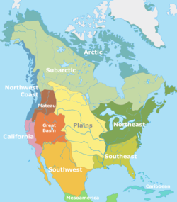
Native American tribes that inhabited the Great Basin were divided between the "Great Basin" and, in the Colorado Desert region, the "California" tribal classifications.
There has been a succession of indigenous peoples of the Great Basin. Paleo-Indian habitation by the Great Basin tribes began as early as 10,000 B.C. .[29]Archaeological evidence of habitation sites along the shore of Lake Lahontan date from the end of the ice age when its shoreline was approximately 500 feet (150m) higher along the sides of the surrounding mountains. The Paleo-Indians were mainly hunters and hunted bison, the extinct mammoth, and extinct ground sloth. For housing, since they followed the animals they were hunting, they had no permanent villages.[30]
The next group to live in the area was the Great Basin Desert Archaic, from approximately 9,000 to 1,500 years ago. They hunted animals like mule deer and antelope and gathered onions, wild rye, and pinyon pine nuts. Then, from 1,500 to 700 years ago, the Fremont lived in the area. Unlike the Paleo-Indians, who moved around to follow bison herds, the Fremont built small villages and grew crops like corn and squash.
Seven hundred years ago, the Shoshone inhabited the area after the Fremont. They were hunter-gathers and lived in temporary homes to be able to follow animal herds and collect plants. Now, Shoshone descendants live in nearby areas.[30] Other tribes in the area included the Ute, Mono, and Northern Paiute. All of the tribes speak a language in the Numic language group.
European exploration of the Great Basin occurred during the 18th century Spanish colonization of the Americas. The first immigrant American to cross the Great Basin from the Sierra Nevada was Jedediah Strong Smith in 1827.[31]Peter Skene Ogden of the British Hudson's Bay Company explored the Great Salt Lake and Humboldt River regions in the late 1820s, following the eastern side of the Sierra Nevada to the Gulf of California.[32]Benjamin Bonneville explored the northeast portion during an 1832 expedition. The United States had acquired claims to the territory north of the 42nd parallel via the 1819 Adams–Onís Treaty with Spain and 1846 Oregon Treaty with Britain. The US gained claims to most of the rest of the Great Basin via the 1848 Mexican Cession. The first non-indigenous settlement was in 1847 in the Great Salt Lake Valley, leading to the first American religious settlement effort of the Mormon provisional State of Deseret in 1849 in present-day Utah and northern Nevada. Later settlements were connected with the eastern regions of the 1848 California Gold Rush, with its immigrants crossing the Great Basin on the California Trail along Nevada's Humboldt River to Carson Pass in the Sierras. The Oregon Territory was established in 1848 and the Utah Territory in 1850.
The climate varies throughout the Great Basin by elevation, latitude, and other factors. Higher elevations tend to be cooler and receive more precipitation. The western areas of the basin tend to be drier than the eastern areas because of the rain shadow of the Sierra Nevada. Most of the basin experiences a semi-arid or arid climate with warm summers and cold winters. However, some of the mountainous areas in the basin are high enough in elevation to experience an alpine climate. Due to the region's altitude and aridity, most areas in the Great Basin experience a substantial diurnal temperature variation.
Significant special designations
Great Basin National Park: President Warren G. Harding created Lehman Caves National Monument by presidential proclamation on January 24, 1922. It was incorporated into the national park on October 27, 1986.
Death Valley National Park: Death Valley National Monument was designated in 1933, and the park was substantially expanded and became a national park in 1994.[34]
Joshua Tree National Park was initially created as a National Monument on 10 August 1936, containing 825,000 acres (334,000ha), after Minerva Hoyt led activism aimed at persuading the state and federal governments at protecting the area.[35] The park was elevated to a National Park on 31 October 1994 by the Desert Protection Act, which also added 234,000 acres to the park.[36]
The Golden Spike National Historic Site was authorized as a National Historic Site under non-federal ownership on April 2, 1957. It was approved for federal ownership and administration by an act of Congress on July 30, 1965. It was redesignated as a National Historical Park in 2019.
↑Hogan, C.Michael; Papineau, Marc; etal. (1987). Development of a dynamic water quality simulation model for the Truckee River. Environmental Protection Agency Technology Series. Washington D.C.: Earth Metrics Inc.
↑Mooney, Walter D; Braile, Lawrence W (1989). "The seismic structure of the continental crust and upper mantle of North America". The Geology of North America – An Overview. Geological Society of America. p.42.
↑Morgan, Dale L (1947). The Great Salt Lake. Salt Lake City: University of Utah Press. p.22. ISBN0-87480-478-7.{{cite book}}: ISBN / Date incompatibility (help)
↑The National Parks Index(PDF). Washington, D.C.: National Park Service. 2003. p.26. Archived from the original(PDF) on 2008-12-19. Retrieved 2008-10-05.
↑Zarki, Joe. "A Park for Minerva". Joshua Tree National Park, NPS. Retrieved 17 December 2013.
↑"Park History". Joshua Tree National Park, NPS. Retrieved 17 December 2013.
This page is based on this Wikipedia article Text is available under the CC BY-SA 4.0 license; additional terms may apply. Images, videos and audio are available under their respective licenses.