Significant cities and metropolitan areas with populations over 250,000 on South America's Caribbean coast include, from west to east: Cartagena (914,552), Barranquilla (2,370,753 metropolitan area), Santa Marta (499,192 district), Maracaibo (5,278,448 metropolitan area), Caracas (8,956,813 metropolitan area), Barcelona (815,141), Puerto La Cruz (454,312), and Cumaná (405,626).
Venezuela is the country with the most extensive coastline on the Caribbean Sea, both relatively and proportionally; it is also the country with the largest recognized maritime territory in this sea. Furthermore, it is the ancestral homeland of the Carib ethnic group, which gave its name to the entire region and is currently located in eastern Venezuela.
↑Zevallos, Luis Ortiz de (1976). Tierra Y Urbe (in Spanish). Unesco, Oficina Regional de Cultura para América Latina y el Caribe, Centro de Documentación.
†Physiographically, these continental islands are not part of the volcanic Windward Islands arc, although sometimes grouped with them culturally and politically.
#Bermuda is an isolated North Atlanticoceanic island, physiographically not part of the Lucayan Archipelago, Antilles, Caribbean Sea nor North American continental nor South American continental islands. It is grouped with the Northern American region, but occasionally also with the Caribbean region culturally.
This page is based on this Wikipedia article Text is available under the CC BY-SA 4.0 license; additional terms may apply. Images, videos and audio are available under their respective licenses.
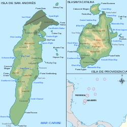
 Department of San Andrés, Providencia and Santa Catalina
