Bajo Nuevo Bank

Last updated • 5 min readFrom Wikipedia, The Free Encyclopedia

Bajo Nuevo Bank
Disputed reef and islands
Bajo Nuevo ISS004-E-7525.jpg
Image of Bajo Nuevo from the ISS
Caribbean location map.svg
Red pog.svg
Bajo Nuevo Bank
Colombia San Andres y Providencia location map.svg
Red pog.svg
Bajo Nuevo Bank
Colombia location map.svg
Red pog.svg
Bajo Nuevo Bank
Other namesPetrel Islands
Geography
Location Caribbean Sea
Coordinates 15°53′N78°38′W / 15.883°N 78.633°W / 15.883; -78.633
Length26 km (16.2 mi)
Width9 km (5.6 mi)
Highest elevation2 m (7 ft)
Highest pointUnnamed location on Low Cay
Administration
Department San Andres and Providencia
Claimed by
Demographics
Population0
Additional information
Time zone

Bajo Nuevo Bank, also known as the Petrel Islands (Spanish : Bajo Nuevo, Islas Petrel), is a small, uninhabited reef with some small grass-covered islets, located in the western Caribbean Sea at 15°53′N78°38′W / 15.883°N 78.633°W / 15.883; -78.633 , with a lighthouse on Low Cay at 15°51′N78°38′W / 15.850°N 78.633°W / 15.850; -78.633 . The closest neighboring land feature is Serranilla Bank, located 110 kilometres (68 miles) to the west.

Contents

The reef was first shown on Dutch maps dating to 1634 but was given its present name in 1654. Bajo Nuevo was rediscovered by the English pirate John Glover in 1660. The reef is now subject to a sovereignty dispute involving Colombia and the United States. On 19 November 2012, regarding Nicaraguan claims to the islands, the International Court of Justice (ICJ) found, unanimously, that the Republic of Colombia has sovereignty over both Bajo Nuevo and Serranilla Banks, although the judgment does not analyze or mention the competing claims of Honduras or the United States. [1]

Geography

Bajo Nuevo Bank is about 26 km (16 mi) long and 9 km (5.6 mi) wide. The satellite image shows two distinct atoll-like structures separated by a deep channel 1.4 km (0.87 mi) wide at its narrowest point. The larger southwestern reef complex measures 15.4 km (9.6 mi) northeast-southwest, and is up to 9.4 km (5.8 mi) wide, covering an area of about 100 km2 (39 sq mi). The reef partially dries on the southern and eastern sides. The smaller northeastern reef complex measures 10.5 km (6.5 mi) east-west and is up to 5.5 km (3.4 mi) wide, covering an area of 45 km2 (17 sq mi). The land area is minuscule by comparison.

The most prominent cay is Low Cay, in the southwestern atoll. It is 300 m (330 yd) long and 40 m (44 yd) wide (about 1 ha or 2.5 acres), no more than 2 m (6.6 ft) high, and barren. It is composed of broken coral, driftwood, and sand. The light beacon on Low Cay is a 21 m (69 ft) metal tower, painted white with a red top. It emits a focal plane beam of light as two white flashes of light every 15 seconds. The beacon was erected in 1982, [2] and reconstructed by the Colombian Ministry of Defence in February 2008. It is currently maintained by the Colombian Navy and overseen by the state's Maritime Authority. [3] [4]

Territorial dispute

Bajo Nuevo Bank is the subject of conflicting claims made by several sovereign states. In most cases, the dispute stems from attempts by a state to expand its exclusive economic zone over the surrounding seas.

Colombia currently claims the area as part of the department of Archipelago of San Andrés, Providencia and Santa Catalina. [5] [6] Naval patrols in the area are carried out by the San Andrés fleet of the Colombian Navy. [7] Colombia maintains that it has claimed these territories since 1886 as part of the geographic archipelago of San Andrés and Providencia. [2] This date is disputed by other claimant states, who argue that Colombia had not claimed the territory by name until recently. [8]

Jamaica's claim has been resolved since entering into several bilateral agreements with Colombia. Between 1982 and 1986, the two states maintained a formal agreement which granted regulated fishing rights to Jamaican vessels within the territorial waters of Bajo Nuevo and nearby Serranilla Bank. [9] [10] Jamaica's signing of this treaty was regarded by critics as a de facto recognition of Colombian sovereignty over the two banks. [10] However, the treaty is now extinguished, as Colombia declined to renew it upon its expiration in August 1986. [10]

In November 1993, Colombia and Jamaica agreed upon a maritime delimitation treaty establishing the Joint Regime Area to cooperatively manage and exploit living and non-living resources in designated waters between the two aforementioned banks. [11] However, the territorial waters immediately surrounding the cays themselves were excluded from the zone of joint-control, as Colombia considers these areas to be part of its coastal waters. [12] [13] The exclusion circles were defined in the chart attached to the treaty as "Colombia's territorial sea in Serranilla and Bajo Nuevo". [10] The agreement came into force in March 1994. [10]

Nicaragua formerly claimed all the islands on its continental shelf, covering an area of over 50,000 km2 in the Caribbean Sea, including Bajo Nuevo Bank and all islands associated with the San Andrés and Providencia archipelagoes. It had persistently pursued this claim against Colombia in the International Court of Justice (ICJ), filing cases in both 2001 and 2007. [8] [14] The dispute originated in the debated validity and applicability of the Esguerr–Bárcenas treaty, exchanged with Colombia in March 1928. [8] Nicaragua formally accepted the ICJ's 2012 ruling of Colombian sovereignty in a 2014 constitutional amendment. [15]

The United States claim was made on 22 November 1869 by James W. Jennett [16] under the provisions of the Guano Islands Act. [17] Most claims made by the U.S. over the guano islands in this region were officially renounced in a treaty with Colombia dated September 1972. [18] However, Bajo Nuevo Bank was not mentioned in the treaty, and Article 7 of the treaty states that matters not specifically mentioned in the treaty are not subject to its terms. The United States considers the bank an insular area. [17] [19]

Honduras, before its ratification of a maritime boundary treaty with Colombia on 20 December 1999, [20] had previously also laid claim to Bajo Nuevo and nearby Serranilla Bank. Both states agreed upon a maritime demarcation in 1986 that excluded Honduras from any control over the banks or their surrounding waters. [21] [22] [23] This bilateral treaty ensured that Honduras implicitly recognized Colombia's sovereignty over the disputed territories. Nicaragua disputed Honduras's legal right to hand over these areas before the ICJ. [24] [25]

See also

Related Research Articles

<span class="mw-page-title-main">Archipelago of San Andrés, Providencia and Santa Catalina</span> Colombian island group in Central America

The Archipelago of San Andrés, Providencia and Santa Catalina, or San Andrés and Providencia, is one of the departments of Colombia, and the only one located geographically in Central America. It consists of two island groups in the Caribbean Sea about 775 km northwest of mainland Colombia, and eight outlying banks and reefs. The largest island of the archipelago and Colombia is called San Andrés and its capital is San Andrés. The other large islands are Providencia and Santa Catalina Islands which lie to the north-east of San Andrés; their capital is Santa Isabel.

<span class="mw-page-title-main">Guano Islands Act</span> Congressional act of the United States

The Guano Islands Act is a United States federal law passed by the Congress that enables citizens of the United States to take possession of unclaimed islands containing guano deposits in the name of the United States. The islands can be located anywhere, so long as they are not occupied by citizens of another country and not within the jurisdiction of another government. It also empowers the president to use the military to protect such interests and establishes the criminal jurisdiction of the United States in these territories.

<span class="mw-page-title-main">Serranilla Bank</span> Colombian-controlled uninhabited reef in the western Caribbean Sea

Serranilla Bank is a partially submerged reef, with small uninhabited islets, in the western Caribbean Sea. It is situated about 350 kilometres (220 mi) northeast of Punta Gorda, Nicaragua, and roughly 280 kilometres (170 mi) southwest of Jamaica. The closest neighbouring land feature is Bajo Nuevo Bank, located 110 kilometres (68 mi) to the east.

<span class="mw-page-title-main">Caribbean Basin</span> Region of North America

The Caribbean Basin or Caribbean Proper is a geopolitical term used to describe countries which generally border the Caribbean Sea. As a geopolitical concept, the term often includes the country of El Salvador, which only touches the Pacific Ocean, for its similarities to neighbouring countries. The definition has also been taken literally at times and can exclude areas such as Barbados and the Turks and Caicos Islands which also do not technically touch the Caribbean Sea.

<span class="mw-page-title-main">Serrana Bank</span> Colombian atoll in the western Caribbean Sea

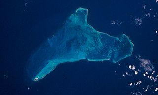
Serrana Bank is a Colombian-administered atoll in the western Caribbean Sea. It is a mostly underwater reef about 50 km long and 13 km wide and has six cays, or islets, the largest of which is Southwest Cay.

<span class="mw-page-title-main">Providencia Island, Colombia</span> One of the two principal islands of San Andrés and Providencia, Colombia

Isla de Providencia, historically Old Providence, and generally known as Providencia or Providence, is a mountainous Caribbean island that is part of the Colombian department of Archipelago of San Andrés, Providencia and Santa Catalina, or The Raizal Islands, and the municipality of Providencia and Santa Catalina Islands, lying midway between Costa Rica and Jamaica.

Rosalind Bank, also called Rosalinda or Rosa Linda Bank, is a large, completely submerged bank or atoll in the western Caribbean Sea. It is the culmination of an area of coral reef, some 300 kilometres (190 mi) long, that extends eastward from Cabo Gracias a Dios. The bank area is part of an extensive structure, known as Nicaragua Rise, that continues further east through Pedro Bank towards Jamaica.

<span class="mw-page-title-main">Alice Shoal</span> Submerged reef in the Caribbean Sea shared between Colombia and Jamaica

Alice Shoal is a wholly submerged reef, located in the western Caribbean Sea, about 260 kilometres southwest of Jamaica. The mainland of Colombia lies 740 kilometres away to the southeast.

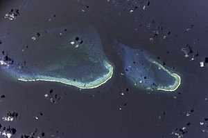
Roncador Cay is a small island of the Roncador Bank, located in the west Caribbean Sea, off the coast of Central America, 150 kilometres east-northeast of Providencia Island.

The Philippines has claims on territories which include the Spratly Islands, portions of North Borneo, and the Scarborough Shoal.

<span class="mw-page-title-main">Quita Sueño Bank</span> Colombian reef formation in the western Caribbean Sea

Quita Sueño Bank is a reef formation of Colombia which was once claimed by the United States, located 110 km north-northeast of Providencia Island.

Territorial disputes of Nicaragua include the territorial dispute with Colombia over the Archipelago of San Andrés, Providencia and Santa Catalina and Quita Sueño Bank. Nicaragua also has a maritime boundary dispute with Honduras in the Caribbean Sea and a boundary dispute over the Rio San Juan with Costa Rica.

<span class="mw-page-title-main">Borders of the United States</span> Political boundaries between the United States and neighboring territories

The United States has land borders with Canada to the North, and Mexico to the South and a maritime boundary with Russia to the West, as well as maritime boundaries with several countries of the extensive exclusive economic zone (EEZ).

<span class="mw-page-title-main">Colombia–Nicaragua relations</span> Bilateral relations

The relationship between the Colombia and Nicaragua has evolved amid conflicts over the San Andrés y Providencia Islands located in the Caribbean Sea close to the Nicaraguan shoreline and the maritime boundaries covering 150,000 km2 that included the islands of San Andrés, Providencia and Santa Catalina and the banks of Roncador, Serrana, Serranilla and Quitasueño as well as the 82nd meridian west which Colombia claims as a border but which the International Court has sided with Nicaragua in disavowing. The sea around the archipelago has been under Colombian control since 1931 when a treaty was signed during US occupation of Nicaragua, giving Colombia control over the area. Both nations are members of the Association of Caribbean States, Community of Latin American and Caribbean States, Organization of American States, Organization of Ibero-American States and the United Nations.

<span class="mw-page-title-main">San Andrés (island)</span> One of the two principal islands of San Andrés and Providencia, Colombia

San Andrés is a coral island in the Caribbean Sea. Politically part of Colombia, and historically tied to the United Kingdom, San Andrés and the nearby islands of Providencia and Santa Catalina form part of the department of San Andrés, Providencia and Santa Catalina; or The Raizal Islands. San Andrés, in the southern group of islands, is the largest of Colombia. The official languages of the department are Spanish, English, and San Andrés–Providencia Creole.

The Esguerra-Bárcenas Treaty was signed between Colombia and Nicaragua on 24 March 1928. Under the terms of the treaty, Nicaragua recognized Colombia's sovereignty over the Archipelago of San Andrés, Providencia and Santa Catalina. Colombia recognized Nicaragua's sovereignty over the Coast of Mosquitos. This treaty is heavily criticized by the Nicaraguan government as it was signed during the United States occupation of Nicaragua.

<span class="mw-page-title-main">Providencia and Santa Catalina Islands</span> Municipality in San Andres and Providencia, Colombia

Providence and Saint Catherine, is a municipality within the department of The Raizal Islands, on the northern coast of Providencia Island which has a population of 5,011 as of (2007), and receives just 15,000 visitors per year. The island is one of Colombia's top scuba diving destinations, with a 32 km long barrier reef protecting the Eastern coast of the island.

<span class="mw-page-title-main">Latin America and the Caribbean</span> Subregion of the Americas

The term Latin America and the Caribbean (LAC) is an English-language acronym referring to the Latin American and the Caribbean region. The term LAC covers an extensive region, extending from The Bahamas and Mexico to Argentina and Chile. The region has over 670,230,000 people as of 2016, and spanned for 21,951,000 square kilometres (8,475,000 sq mi).

<span class="mw-page-title-main">Mauricio Herdocia Sacasa</span> Nicaraguan lawyer and diplomat (1957–2021)

Mauricio Herdocia Sacasa was a Nicaraguan jurist who specialized in international law, and diplomat. He held roles in the Nicaraguan government, especially in the Foreign Ministry, across party lines, as well as roles in major international legal bodies including at the United Nations and the Organization of American States. In the 1980s, he worked on a number of peace processes in Central America, helping formalize legal and political structures for the region. Also a legal scholar and professor, he was rector of the American College University and the author of four books on the laws governing the sovereignty and territorial integrity of Nicaragua. His contributions were recognized with a number of honors both nationally and internationally, including Nicaragua's Order of Rubén Darío.

<span class="mw-page-title-main">Borders of Colombia</span>

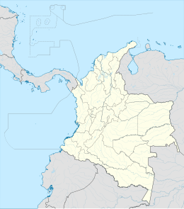
Colombia is located in the northwestern corner of South America, confined between the vast Amazon rainforest and the Atlantic and Pacific oceans, and also crossed by the great Andes mountain range. Due to this territorial conformation, it has both natural and political boundaries; as a complement to the latter definition, there are the so-called borders. The country exercises its sovereignty within the territory comprised by these.

References

  1. International Court of Justice (2012). "Territorial and maritime dispute (Nicaragua vs Colombia)" (PDF). Retrieved 27 November 2012.
  2. 1 2 "Anexo 7" (PDF) (in Spanish). Colombian Government, Ministry of National Defence. August 1997. Archived from the original (PDF) on 9 October 2011. Retrieved 22 December 2009. Legal status of the Banks of Serranilla and Bajo Nuevo, page 8.
  3. "Contract No. 153" (PDF) (in Spanish). Colombian Government, Ministry of National Defence. February 2008. Archived from the original (PDF) on 7 July 2011. Retrieved 23 October 2009. Contract detail between Colombian Defence Ministry and private contractor, Tecnosoluciones Ltda, for the replacement of various metal lighthouse structures, including on Bajo Nuevo Bank.
  4. "Grupo de Señalización Marítima del Caribe" (PDF) (in Spanish). Colombian Government, Ministry of National Defence. May 2008. Archived from the original (PDF) on 7 July 2011. Retrieved 16 November 2009. Photographs of Colombian lighthouses, with Bajo Nuevo Bank shown, pages 4–5.
  5. "Historia del Departamento Archipiélago" (in Spanish). Government of the San Andrés Department. 2008. Archived from the original on 7 July 2011. Retrieved 20 December 2009. Description and general history of the Department of San Andrés, Providencia and Santa Catalina.
  6. "Mapa Oficial Fronteras Terrestriales y Maritima Convenciones" (PDF). Instituto Geográfico Agustín Codazzi . Retrieved 25 October 2009.[ permanent dead link ] An official map of Colombian borders, with treaty dates.
  7. (in Spanish) Armada de la República de Colombia: Forces and Commands Archived 2 September 2017 at the Wayback Machine – area is under the jurisdiction of Comando Específico de San Andrés y Providencia.
  8. 1 2 3 "Territorial and Maritime Dispute" (PDF). International Court of Justice. December 2007. Retrieved 17 November 2009. Nicaragua v. Colombia, Preliminary Objections.
  9. "Fishing Agreement Between Jamaica and the Republic of Colombia" (PDF). United Nations. November 1982. Retrieved 20 November 2009. Fishing agreement which permits regulated fishing rights to Jamaican vessels around Bajo Nuevo and Serranilla Banks.
  10. 1 2 3 4 5 Charney, Jonathan; American Society of International Law (2004). International Maritime Boundaries, Vol. 2–3. Boston, United States: Martinus Nijhoff Publishers. p. 2616. ISBN   978-90-411-0345-1. p2179-2192.
  11. Colombia Jamaica Joint Regime Treaty
  12. "Sentencia No. C-045/94" (in Spanish). Government of Colombia, Secretaría del Senado. February 1994. Archived from the original on 7 July 2011. Retrieved 22 November 2009. Review of the 1993 Maritime Delimitation Treaty between Colombia and Jamaica.
  13. "Continental, Coastal and Marine Ecosystems of Colombia, 1 of 36" (PDF). José Benito Vives de Andréis Marine and Coastal Research Institute (INVEMAR). 2001. Retrieved 22 December 2009. Topographic map of the Colombia-Jamaica Joint-Regime Area, with the two exclusion circles shown.
  14. International Court of Justice: Nicaragua v. Colombia – Press Release, 2001.
  15. "Nicaragua 1987 (rev. 2014) Constitution - Constitute". www.constituteproject.org. Retrieved 13 December 2023.
  16. Moore, John Bassett; United States Government, Department of State (1906). A Digest of International Law, Vol. 8. Washington, United States: Government Printing Office. p. 788. ISBN   978-1-4432-8111-9. p77.
  17. 1 2 "Acquisition Process of Insular Areas". United States Government, Department of the Interior. Archived from the original on 14 April 2012. Retrieved 13 January 2008. Lists Bajo Nuevo Bank as an insular area under U.S. sovereignty.
  18. (in Spanish) Treaty of exchange between Colombia and the United States, 1972 Archived 24 May 2011 at the Wayback Machine
  19. "Application of the U.S. Constitution" (PDF). United States Government, General Accounting Office. November 1997. Archived (PDF) from the original on 16 February 2008. Retrieved 13 January 2008. Page 39 states that U.S. sovereignty over Bajo Nuevo is disputed. "Currently, the United States conducts maritime law enforcement operations in and around Serranilla Bank and Bajo Nuevo consistent with U.S. sovereignty claims." This is the only archived document from this source that mentions Bajo Nuevo Bank as an insular area. [ dead link ]
  20. (in Spanish) Affirmation of Maritime Delimitation Treaty between Honduras and Colombia, 1999
  21. (in Spanish) Treaty between Colombia and Honduras, 1986
  22. (in Spanish) Republic of Honduras: Political Constitution of 1982 through 2005 reforms
  23. The American Society of International Law Archived 2 September 2009 at the Wayback Machine – see map at top of article.
  24. The Republic of Nicaragua v. The Republic of Colombia, CCJ Case File Archived 9 October 2011 at the Wayback Machine
  25. Nicaragua-Honduras Territorial Dispute Archived 27 September 2009 at the Wayback Machine De Mar, Rebecca. American University, June 2002.