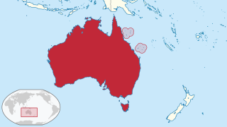
The Coral Sea Islands Territory is an external territory of Australia which comprises a group of small and mostly uninhabited tropical islands and reefs in the Coral Sea, north-east of Queensland, Australia. The only inhabited island is Willis Island. The territory covers 780,000 km2 (301,160 sq mi), most of which is ocean, extending east and south from the outer edge of the Great Barrier Reef and includes Heralds Beacon Island, Osprey Reef, the Willis Group and fifteen other reef/island groups. Cato Island is the highest point in the Territory.

An island or isle is a piece of subcontinental land completely surrounded by water. Very small islands such as emergent land features on atolls can be called islets, skerries, cays or keys. An island in a river or a lake island may be called an eyot or ait, and a small island off the coast may be called a holm. Sedimentary islands in the Ganges Delta are called chars. A grouping of geographically or geologically related islands, such as the Philippines, is referred to as an archipelago.
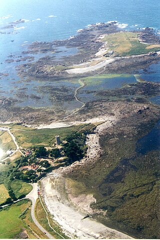
Lihou is a small tidal island located just off the west coast of the island of Guernsey, in the English Channel, between Great Britain and France. Administratively, Lihou forms part of the Parish of St. Peter's in the Bailiwick of Guernsey, and is now owned by the parliament of Guernsey, although there have been a number of owners in the past. Since 2006, the island has been jointly managed by the Guernsey Environment Department and the Lihou Charitable Trust. In the past the island was used by locals for the collection of seaweed for use as a fertiliser, but today Lihou is mainly used for tourism, including school trips. Lihou is also an important centre for conservation, forming part of a Ramsar wetland site for the preservation of rare birds and plants as well as historic ruins of a priory and a farmhouse.

The Coral Sea is a marginal sea of the South Pacific off the northeast coast of Australia, and classified as an interim Australian bioregion. The Coral Sea extends 2,000 kilometres (1,200 mi) down the Australian northeast coast. Most of it is protected by the French Natural Park of the Coral Sea and the Australian Coral Sea Marine Park. The sea was the location for the Battle of the Coral Sea, a major confrontation during World War II between the navies of the Empire of Japan, and the United States and Australia.

Bora Bora is an island group in the Leeward Islands. The Leeward Islands comprise the western part of the Society Islands of French Polynesia, which is an overseas collectivity of the French Republic in the Pacific Ocean. Bora Bora has a total land area of 30.55 km2 (12 sq mi). The main island, located about 230 kilometres northwest of Papeete, is surrounded by a lagoon and a barrier reef. In the center of the island are the remnants of an extinct volcano, rising to two peaks, Mount Pahia and Mount Otemanu; the highest point is at 727 m (2,385 ft). Bora Bora is part of the Commune of Bora-Bora, which also includes the atoll of Tūpai. The languages spoken in Bora Bora are Tahitian and French. However, due to the high tourism population, many natives of Bora Bora have learned to speak English.
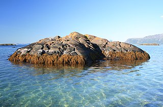
A skerry is a small rocky island, or islet, usually too small for human habitation. It may simply be a rocky reef. A skerry can also be called a low sea stack.

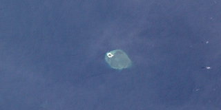
Motu One is the name of a small sandbank with no vegetation, located on the western edge of a coral reef; the only atoll in the Marquesas Islands. The reef is approximately 5 kilometres (3.1 mi) in diameter, and the islet has a surface area of less than one hectare, rising only a few feet above sea level and changing shape regularly as the action of the currents deposits and removes sand.

Okinotorishima, or Parece Vela, is a coral reef with two rocks enlarged with tetrapod-cement structures. It is administered by Japan with a total shoal area of 8,482 m2 and land area 9.44 m2 (101.6 sq ft). Its dry land area is mostly made up by three concrete encasings and there is a 100 by 50 m stilt platform in the lagoon housing a research station. There is a third completely artificial tetrapod-cement islet.

Bikar Atoll is an uninhabited atoll in the Ratak Chain of the Marshall Islands. It is one of the smallest atolls in the Marshalls. Due to its relative isolation from the main islands in the group, Bikar's flora and fauna has been able to exist in a relatively pristine condition.

A river island is any exposed landmass surrounded by river water. Properly defined, it excludes shoals between seasonally varying flows and may exclude semi-coastal islands such as in river deltas.
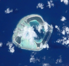
Motu One, also known as Bellinghausen, is an atoll in the Leeward group of the Society Islands. Motu One is located 550 km northwest from Tahiti and 72 km northeast of Manuae, its closest neighbor.

Chiswick Eyot is a 3.266-acre (1.3 ha) narrow, uninhabited ait of the Thames. It is a tree- and reed-covered rise on the Tideway by Chiswick, in London, England and is overlooked by Chiswick Mall and by some of the Barnes riverside on the far bank.

The Chesterfield Islands are a French archipelago of New Caledonia located in the Coral Sea, 550 km (300 nmi) northwest of Grande Terre, the main island of New Caledonia. The archipelago is 120 km long and 70 km broad, made up of 11 uninhabited islets and many reefs. The land area of the islands is less than 10 km2.

Saumarez Reef is one of the southernmost reefs to be located in the Coral Sea Islands and part of the Coral Sea Shelf; it contains three main reefs and numerous smaller reefs all of which form a large crescent-shaped formation open to the northwest, about 27 by 14 km, area less than 300 km2.
The Wreck Reefs are located in the southern part of the Coral Sea Islands approximately 450 kilometres (280 mi) east-north-east of Gladstone, Queensland, Australia.
Bramble Cay, also known as Maizab Kaur and Massaramcoer, is a small cay located at the northeastern edge of Australia and the Torres Strait Islands of Queensland and at the northern end of the Great Barrier Reef. Lying around 50 km (31 mi) north of Erub Island in the Gulf of Papua, it is the northernmost point of land of Australia and marks the end of the Great Barrier Reef.
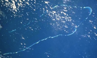
The Coral Sea Reserves Ramsar Site comprises the 17,289 km2 of oceanic island and reef habitats within the former Coringa-Herald National Nature Reserve and the former Lihou Reef National Nature Reserve in the Australian Coral Sea Islands Territory.

Coringa-Herald National Nature Reserve is a former nature reserve in Australia’s Coral Sea Islands Territory that was incorporated into the new Coral Sea Commonwealth Marine Reserve in December 2012. The former nature reserve together with the Lihou Reef National Nature Reserve is part of the Coral Sea Reserves Ramsar Site. Its extent is also within the Coringa-Herald Reefs Important Bird Area.

Pelorus Islet is an islet in the Australian state of South Australia located in Great Australian Bight off the south coast of Kangaroo Island approximately 7 kilometres east south-east of Cape Gantheaume. It was named by Captain Francis Harding, RN after HMS Pelorus.