Related Research Articles

Downwelling is the downward movement of a fluid parcel and its properties within a larger fluid. It is closely related to upwelling, the upward movement of fluid.

An estuary is a partially enclosed coastal body of brackish water with one or more rivers or streams flowing into it, and with a free connection to the open sea. Estuaries form a transition zone between river environments and maritime environments and are an example of an ecotone. Estuaries are subject both to marine influences such as tides, waves, and the influx of saline water, and to fluvial influences such as flows of freshwater and sediment. The mixing of seawater and freshwater provides high levels of nutrients both in the water column and in sediment, making estuaries among the most productive natural habitats in the world.

A continental shelf is a portion of a continent that is submerged under an area of relatively shallow water, known as a shelf sea. Much of these shelves were exposed by drops in sea level during glacial periods. The shelf surrounding an island is known as an insular shelf.

The spring bloom is a strong increase in phytoplankton abundance that typically occurs in the early spring and lasts until late spring or early summer. This seasonal event is characteristic of temperate North Atlantic, sub-polar, and coastal waters. Phytoplankton blooms occur when growth exceeds losses, however there is no universally accepted definition of the magnitude of change or the threshold of abundance that constitutes a bloom. The magnitude, spatial extent and duration of a bloom depends on a variety of abiotic and biotic factors. Abiotic factors include light availability, nutrients, temperature, and physical processes that influence light availability, and biotic factors include grazing, viral lysis, and phytoplankton physiology. The factors that lead to bloom initiation are still actively debated.
Saltwater intrusion is the movement of saline water into freshwater aquifers, which can lead to groundwater quality degradation, including drinking water sources, and other consequences. Saltwater intrusion can naturally occur in coastal aquifers, owing to the hydraulic connection between groundwater and seawater. Because saline water has a higher mineral content than freshwater, it is denser and has a higher water pressure. As a result, saltwater can push inland beneath the freshwater. In other topologies, submarine groundwater discharge can push fresh water into saltwater.
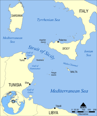
The Strait of Sicily is the strait between Sicily and Tunisia. The strait is about 145 kilometres (90 mi) wide and divides the Tyrrhenian Sea and the western Mediterranean Sea, from the eastern Mediterranean Sea. The maximum depth is 316 meters (1,037 ft). The island of Pantelleria lies in the middle of the strait.

Meroplankton are a wide variety of aquatic organisms which have both planktonic and benthic stages in their life cycles. Much of the meroplankton consists of larval stages of larger organism. Meroplankton can be contrasted with holoplankton, which are planktonic organisms that stay in the pelagic zone as plankton throughout their entire life cycle.

The Alaska Current is a southwestern shallow warm-water current alongside the west coast of the North American continent beginning at about 48-50°N. The Alaska Current produces large clockwise eddies at two sites: west of the Haida Gwaii and west of Sitka, Alaska.

The Norwegian Current is one of two dominant arctic inflows of water. It can be traced from near Shetland, north of Scotland, otherwise from the eastern North Sea at depths of up to 100 metres. It finally passes the opening into the Barents Sea, a large outcrop of the Arctic Ocean. Compared to its partial source the North Atlantic Current it is colder and less salty; the other sources are the less saline North and Baltic seas and the Norwegian fjords and rivers. It is considerably warmer and saltier than the Arctic Ocean, which is freshened by precipitation and ice in and around it. Winter temperatures in the flow are typically between 2 and 5 °C — the co-parent North Atlantic flow, a heat remnant of its Gulf Stream chief contributor, exceeds 6 °C.
A tidal river is a river whose flow and level are caused by tides. A section of a larger river affected by the tides is a tidal reach, but it may sometimes be considered a tidal river if it had been given a separate and another title name.

The Ocean Observatories Initiative (OOI) is a National Science Foundation (NSF) Major Research Facility composed of a network of science-driven ocean observing platforms and sensors in the Atlantic and Pacific Oceans. This networked infrastructure measures physical, chemical, geological, and biological variables from the seafloor to the sea surface and overlying atmosphere, providing an integrated data collection system on coastal, regional and global scales. OOI's goal is to deliver data and data products for a 25-year-plus time period, enabling a better understanding of ocean environments and critical ocean issues.

The Surface Water and Ocean Topography (SWOT) mission is a satellite altimeter jointly developed and operated by NASA and CNES, the French space agency, in partnership with the Canadian Space Agency (CSA) and UK Space Agency (UKSA). The objectives of the mission are to make the first global survey of the Earth's surface water, to observe the fine details of the ocean surface topography, and to measure how terrestrial surface water bodies change over time.
Estuarine water circulation is controlled by the inflow of rivers, the tides, rainfall and evaporation, the wind, and other oceanic events such as an upwelling, an eddy, and storms. Estuarine water circulation patterns are influenced by vertical mixing and stratification, and can affect residence time and exposure time.
In oceanography, a front is a boundary between two distinct water masses. The formation of fronts depends on multiple physical processes and small differences in these lead to a wide range of front types. They can be as narrow as a few hundreds of metres and as wide as several tens of kilometres. While most fronts form and dissipate relatively quickly, some can persist for long periods of time.
Estuary freshwater inflow is the freshwater that flows into an estuary. Other types of environmental flows include instream flow, the freshwater water flowing in rivers or streams, and estuary outflow, the outflow from an estuary to the ocean.

Haida Eddies are episodic, clockwise rotating ocean eddies that form during the winter off the west coast of British Columbia's Haida Gwaii and Alaska's Alexander Archipelago. These eddies are notable for their large size, persistence, and frequent recurrence. Rivers flowing off the North American continent supply the continental shelf in the Hecate Strait with warmer, fresher, and nutrient-enriched water. Haida eddies are formed every winter when this rapid outflow of water through the strait wraps around Cape St. James at the southern tip of Haida Gwaii, and meets with the cooler waters of the Alaska Current. This forms a series of plumes which can merge into large eddies that are shed into the northeast Pacific Ocean by late winter, and may persist for up to two years.

Lough Furnace is a tidally-influenced, meromictic, saline lagoon in County Mayo, Ireland, located south of Lough Feeagh. It receives freshwater inflow from the upstream Lough Feeagh at the base of the Burrishoole Catchment and tidal input of saline water from Clew Bay, through the Burrishoole Estuary.

A river plume is a freshened water mass that is formed in the sea as a result of mixing of river discharge and saline seawater. River plumes are formed in coastal sea areas at many regions in the World. River plumes generally occupy wide-but-shallow sea surface layers bounded by sharp density gradients. The area of a river plume is 3-5 orders of magnitude greater than its depth; therefore, even small rivers with discharge rates ~1–10 m/s form river plumes with horizontal spatial extents ~10–100 m. Areas of river plumes formed by the largest rivers are ~100–1000 km2. Despite the relatively small volume of total freshwater runoff to the World Ocean, river plumes occupy up to 21% of shelf areas of the ocean, i.e., several million square kilometers.

Stratification in water is the formation in a body of water of relatively distinct and stable layers by density. It occurs in all water bodies where there is stable density variation with depth. Stratification is a barrier to the vertical mixing of water, which affects the exchange of heat, carbon, oxygen and nutrients. Wind-driven upwelling and downwelling of open water can induce mixing of different layers through the stratification, and force the rise of denser cold, nutrient-rich, or saline water and the sinking of lighter warm or fresher water, respectively. Layers are based on water density: denser water remains below less dense water in stable stratification in the absence of forced mixing.
Oceanic freshwater fluxes are defined as the transport of non saline water between the oceans and the other components of the Earth's system. These fluxes have an impact on the local ocean properties, as well as on the large scale circulation patterns.
References
- ↑ John Simpson. "Biography". University of Wales, Bangor. Archived from the original on July 16, 2011. Retrieved October 29, 2009.
- ↑ Alexander Osadchiev, Peter Zavialov (2020). "Structure and Dynamics of Plumes Generated by Small Rivers". Estuaries and Coastal Zones - Dynamics and Response to Environmental Changes. IntechOpen. doi:10.5772/intechopen.87843. ISBN 978-1-78985-579-1. S2CID 200219266 . Retrieved February 13, 2021.

