
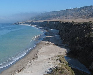
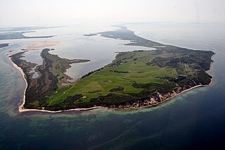
A cliffed coast, also called an abrasion coast, is a form of coast where the action of marine waves has formed steep cliffs that may or may not be precipitous. It contrasts with a flat or alluvial coast.
A cliffed coast, also called an abrasion coast, is a form of coast where the action of marine waves has formed steep cliffs that may or may not be precipitous. It contrasts with a flat or alluvial coast.
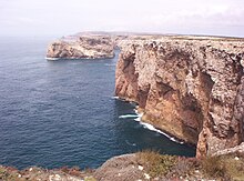
In coastal areas in which the land surface dips at a relatively steep angle below the water table, the continuous action of marine waves on the coastline, known as abrasion, may create a steep declivity known as a cliff, the slope angle of which depends on a variety of factors including the jointing, bedding and hardness of the materials making up the cliff as well as the erosional processes themselves. [1] [2] The slope is constantly being eroded. The waves attacking the cliff-foot form a wave-cut notch by constant abrasion action producing an overhang. This overhang grows in size as the cliff is undercut, until it collapses under its own weight. The loose debris that has broken off is gradually carried away from the area in front of the cliff by the action of the sea. As the coastal cliffs collapse, the shoreline recedes inland. The speed at which this happens depends, in particular, on the strength of the surf, the height of the cliff, the frequency of storm surges and the hardness of the bedrock. Thus, the Mecklenburg coast in Germany recedes by about 25 centimetres per year, whereas the chalk cliffs of southern England retreat by just half a centimetre each year. A cliffed coast is made of a loose bedrock material, such as at the Red Cliff on the German island of Sylt, but can also occur in hard rock like the red sandstone cliffs on Heligoland. There are, however, differences between the former and the latter regarding some peculiarities of the coast line.
In the case of the large and widespread coastal cliffs of Atacama Desert the modern cliffs originated from a process of scarp retreat of a fault scarp, thus at present the cliffs do not follow any geological fault. [3]
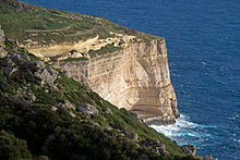
On a rocky cliffed coast made up of material which is relatively resistant to erosion such as sandstone, limestone or granite, a flat rocky wave-cut platform or abrasion platform is formed in front of the cliff. It represents the foot of the cliff preserved at and below the level of water table. If there is a tectonic uplift of the coast, these abrasion platforms can be raised to form coastal terraces, from which the amount of uplift can be calculated from their elevation relative to the sea level, taking into account any eustatic sea level changes. On a cliffed coast made up of material which is only fairly or even hardly resistant to erosion no wave-cut platform but a beach is formed in front of the sea cliff.
If waves carve notches at a narrow point on both sides of a promontory on the rocky cliffed coast, a natural arch may be formed. [4] When the arch collapses as the coastline recedes further a stack is left behind on the wave-cut platform. The best-known example in Germany is the Lange Anna on Heligoland, while, in England, a prominent example are Old Harry Rocks in Dorset.

Furthermore, on a rocky cliffed coast wave action is not the only driving force for coastline retreat. General weathering of the bedrock is almost equally important. [2]
"Living cliffs" are those on a coast that is still active, i.e. that is being eroded and is receding. A "dead cliff", by contrast, is only reached by very high marine waves and is therefore subjected to very little change. A clear indication of a lack of activity at a dead cliff is a covering of vegetation that appears on the cliff as wave action against it subsides.
Well-known coasts with living cliffs in Germany are the Red Cliff (Rote Kliff) in Kampen on the island of Sylt or the chalk cliffs on the Jasmund Peninsula. The Königsstuhl on the island of Rügen is a good example of a dead cliff. Others may be found in the regions of the present-day Wadden Sea coast of the North Sea a few kilometres inland. These show the former coastline from which the sea retreated as the level of water in the North Sea fell.
Steep sea cliffs can also be caused by catastrophic debris avalanches. These have been common on the submerged flanks of ocean island volcanos such as the Hawaiian Islands and the Cape Verde Islands. [5] [6]

A coast – also called the coastline, shoreline, or seashore – is the land next to the sea or the line that forms the boundary between the land and the ocean or a lake. Coasts are influenced by the topography of the surrounding landscape, as well as by water induced erosion, such as waves. The geological composition of rock and soil dictates the type of shore that is created. Earth contains roughly 620,000 km (390,000 mi) of coastline.

Erosion is the action of surface processes that removes soil, rock, or dissolved material from one location on the Earth's crust and then transports it to another location where it is deposited. Erosion is distinct from weathering which involves no movement. Removal of rock or soil as clastic sediment is referred to as physical or mechanical erosion; this contrasts with chemical erosion, where soil or rock material is removed from an area by dissolution. Eroded sediment or solutes may be transported just a few millimetres, or for thousands of kilometres.

Coastal erosion is the loss or displacement of land, or the long-term removal of sediment and rocks along the coastline due to the action of waves, currents, tides, wind-driven water, waterborne ice, or other impacts of storms. The landward retreat of the shoreline can be measured and described over a temporal scale of tides, seasons, and other short-term cyclic processes. Coastal erosion may be caused by hydraulic action, abrasion, impact and corrosion by wind and water, and other forces, natural or unnatural.

A stack or sea stack is a geological landform consisting of a steep and often vertical column or columns of rock in the sea near a coast, formed by wave erosion. Stacks are formed over time by wind and water, processes of coastal geomorphology. They are formed when part of a headland is eroded by hydraulic action, which is the force of the sea or water crashing against the rock. The force of the water weakens cracks in the headland, causing them to later collapse, forming free-standing stacks and even a small island. Without the constant presence of water, stacks also form when a natural arch collapses under gravity, due to sub-aerial processes like wind erosion. Erosion causes the arch to collapse, leaving the pillar of hard rock standing away from the coast—the stack. Eventually, erosion will cause the stack to collapse, leaving a stump. Stacks can provide important nesting locations for seabirds, and many are popular for rock climbing.
Landforms are categorized by characteristic physical attributes such as their creating process, shape, elevation, slope, orientation, rock exposure, and soil type.
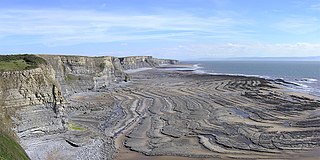
A wave-cut platform, shore platform, coastal bench, or wave-cut cliff is the narrow flat area often found at the base of a sea cliff or along the shoreline of a lake, bay, or sea that was created by erosion. Wave-cut platforms are often most obvious at low tide when they become visible as huge areas of flat rock. Sometimes the landward side of the platform is covered by sand, forming the beach, and then the platform can only be identified at low tides or when storms move the sand.
A raised beach, coastal terrace, or perched coastline is a relatively flat, horizontal or gently inclined surface of marine origin, mostly an old abrasion platform which has been lifted out of the sphere of wave activity. Thus, it lies above or under the current sea level, depending on the time of its formation. It is bounded by a steeper ascending slope on the landward side and a steeper descending slope on the seaward side. Due to its generally flat shape, it is often used for anthropogenic structures such as settlements and infrastructure.

Old Harry Rocks are three chalk formations, including a stack and a stump, located at Handfast Point, on the Isle of Purbeck in Dorset, southern England. They mark the most eastern point of the Jurassic Coast, a UNESCO World Heritage Site.

Coastal geography is the study of the constantly changing region between the ocean and the land, incorporating both the physical geography and the human geography of the coast. It includes understanding coastal weathering processes, particularly wave action, sediment movement and weather, and the ways in which humans interact with the coast.

In geology, a terrace is a step-like landform. A terrace consists of a flat or gently sloping geomorphic surface, called a tread, that is typically bounded on one side by a steeper ascending slope, which is called a "riser" or "scarp". The tread and the steeper descending slope together constitute the terrace. Terraces can also consist of a tread bounded on all sides by a descending riser or scarp. A narrow terrace is often called a bench.

Downcutting, also called erosional downcutting, downward erosion or vertical erosion, is a geological process by hydraulic action that deepens the channel of a stream or valley by removing material from the stream's bed or the valley's floor. The speed of downcutting depends on the stream's base level, the lowest point to which the stream can erode. Sea level is the ultimate base level, but many streams have a higher "temporary" base level because they empty into another body of water that is above sea level or encounter bedrock that resists erosion. A concurrent process called lateral erosion refers to the widening of a stream channel or valley. When a stream is high above its base level, downcutting will take place faster than lateral erosion; but as the level of the stream approaches its base level, the rate of lateral erosion increases. This is why streams in mountainous areas tend to be narrow and swift, forming V-shaped valleys, while streams in lowland areas tend to be wide and slow-moving, with valleys that are correspondingly wide and flat-bottomed. The term gradient refers to the elevation of a stream relative to its base level. The steeper the gradient, the faster the stream flows. Sometimes geological uplift will increase the gradient of a stream even while the stream downcuts toward its base level, a process called "rejuvenation." This happened in the case of the Colorado River in the western United States, resulting in the process that created the Grand Canyon.

Abrasion is a process of weathering that occurs when material being transported wears away at a surface over time, commonly happens in ice and glaciers. The primary process of abrasion is physical weathering. Its the process of friction caused by scuffing, scratching, wearing down, marring, and rubbing away of materials. The intensity of abrasion depends on the hardness, concentration, velocity and mass of the moving particles. Abrasion generally occurs in four ways: glaciation slowly grinds rocks picked up by ice against rock surfaces; solid objects transported in river channels make abrasive surface contact with the bed with ppl in it and walls; objects transported in waves breaking on coastlines; and by wind transporting sand or small stones against surface rocks. Abrasion is the natural scratching of bedrock by a continuous movement of snow or glacier downhill. This is caused by a force, friction, vibration, or internal deformation of the ice, and by sliding over the rocks and sediments at the base that causes the glacier to move.
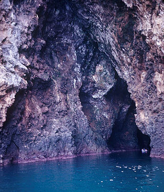
A sea cave, is also known as a littoral cave, a type of cave formed primarily by the wave action of the sea. The primary process involved is erosion. Sea caves are found throughout the world, actively forming along present coastlines and as relict sea caves on former coastlines. Some of the largest wave-cut caves in the world are found on the coast of Norway, but are now 100 feet or more above present sea level. These would still be classified as littoral caves. By contrast, in places like Thailand's Phang Nga Bay, solutionally formed caves in limestone have been flooded by the rising sea and are now subject to littoral erosion, representing a new phase of their enlargement.
Beach evolution occurs at the shoreline where sea, lake or river water is eroding the land. Beaches exist where sand accumulated from centuries-old, recurrent processes that erode rocky and sedimentary material into sand deposits. River deltas deposit silt from upriver, accreting at the river's outlet to extend lake or ocean shorelines. Catastrophic events such as tsunamis, hurricanes, and storm surges accelerate beach erosion.
Attrition is the process of erosion that occurs during rock collision and transportation. The transportation of sediment chips and smooths the surfaces of bedrock; this can be through water or wind. Rocks undergoing attrition erosion are often found on or near the bed of a stream. Attrition is also partially responsible for turning boulders into smaller rocks and eventually to sand.

Cape Town lies at the south-western corner of the continent of Africa. It is bounded to the south and west by the Atlantic Ocean, and to the north and east by various other municipalities in the Western Cape province of South Africa.
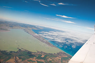
The Canterbury Bight is a large bight on the eastern side of New Zealand's South Island. The bight runs for approximately 135 kilometres (84 mi) from the southern end of Banks Peninsula to the settlement of Timaru and faces southeast, exposing it to high-energy storm waves originating in the Pacific Ocean. The bight is known for rough conditions as a result, with wave heights of over 2 metres (6.6 ft) common. Much of the bight's geography is shaped by this high-energy environment interacting with multiple large rivers which enter the Pacific in the bight, such as the Rakaia, Ashburton / Hakatere, and Rangitata Rivers. Sediment from these rivers, predominantly Greywacke, is deposited along the coast and extends up to 50 kilometres (31 mi) out to sea from the current shoreline. Multiple hapua, or river-mouth lagoons, can be found along the length of the bight where waves have deposited sufficient sediment to form a barrier across a river mouth, including most notably Lake Ellesmere / Te Waihora and Washdyke Lagoon

The Rotes Kliff is a around 30-metre high line of sea cliffs between the villages of Wenningstedt and Kampen on the German North Sea island of Sylt. It is located on the west side of the island facing the open sea, beginning in the south at the car park of "Risgap" in Wenningstedt and ending in the north at Haus Kliffende on the Kampen West Heath.

A steep coast is a stretch of coastline where the mainland descends abruptly into the sea. There is a sharp transition from the land to sea as opposed to that on a flat coast where the land descends gradually seawards. The height of the land on a steep coast is well above sea level.
The Dornbusch is a region of low rolling hills in the northern part of the German Baltic Sea island of Hiddensee. It consists mainly of ice age depositions, that were left behind after the glacier thawed. It is one of three island cores of the Hiddensee responsible for the emergence of the lowland.

