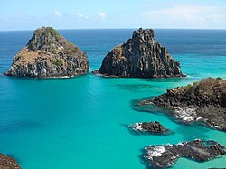
Steep coast

Last updated
View of the steep coast on the island of Dugi Otok in Croatia Dugi Otok Telascica.jpg
View of the steep coast on the island of Dugi Otok in Croatia

A steep coast [1] is a stretch of coastline where the mainland descends abruptly into the sea. There is a sharp transition from the land to sea as opposed to that on a flat coast where the land descends gradually seawards. The height of the land on a steep coast is well above sea level.

Most steep coast are rocky cliffed coasts (also called abrasion coasts), where the erosion processes of wave action result in a steep declivity. Another type of steep coast is the fjord which is formed when a glacial valley lies partially under water as a result of a rise in sea levels. In Norway, New Zealand or Alaska there are fjords whose almost vertical sides tower over 1,000 metres above the water and plunge 300 metres below it.

On volcanic islands the sea can enter the caldera and the face of the volcanic pipe can form a steep coastline. The best-known example of that is Santorini in the archipelago of the Cyclades in Greeces. Fira, the main town of the island, lies on the rim of the caldera which is around 300 metres above the sea and drops below it for another 200 metres.

Related Research Articles

Coast Area where land meets the sea or ocean

The coast, also known as the coastline or seashore, is defined as the area where land meets the sea or ocean, or as a line that forms the boundary between the land and the ocean or a lake. Earth has around 620,000 kilometres (390,000 mi) of coastline. Because coasts are constantly changing, a coastline's exact perimeter cannot be determined; this measurement challenge is called the coastline paradox. The term coastal zone is used to refer to a region where interactions of sea and land processes occur. Both the terms coast and coastal are often used to describe a geographic location or region located on a coastline

Geography of Dominica

Dominica is an island in the Caribbean Sea, located about halfway between the French islands of Guadeloupe and Martinique. Its coordinates are 15 25 N, 61 20 W. It is known as "The Nature Island of the Caribbean" due to its spectacular, lush, and varied flora and fauna, which is protected by an extensive natural park system. It is the fourth largest island in the Eastern Caribbean with a population of people mainly of African descent.

Fjord A long, narrow inlet with steep sides or cliffs, created by glacial activity

In geology, a fjord or fiord is a long, narrow inlet with steep sides or cliffs, created by a glacier. There are many fjords on the coasts of Alaska, Antarctica, British Columbia, Chile, Denmark, Greenland, the Faroe Islands, Iceland, Ireland, Kamchatka, the Kerguelen Islands, New Zealand, Norway, Novaya Zemlya, Labrador, Nunavut, Newfoundland, Quebec, Scotland, South Georgia Island, Isla de los Estados, and Washington state. Norway's coastline is estimated at 29,000 kilometres (18,000 mi) with nearly 1,200 fjords, but only 2,500 kilometres (1,600 mi) when fjords are excluded.

Geography of Madagascar Overview of the geography of Madagascar

Madagascar is a large island in the Indian Ocean off the eastern coast of southern Africa, east of Mozambique. It has a total area of 587,040 square kilometres (226,660 sq mi) with 581,540 square kilometres (224,530 sq mi) of land and 5,500 square kilometres (2,100 sq mi) of water. Madagascar is the fourth largest island and the 2nd largest island country in the world. The highest point is Maromokotro, in the Tsaratanana Massif region in the north of the island, at 2,876 metres (9,436 ft). The capital Antananarivo is in the Central Highlands near the centre of the island. It has the 25th largest Exclusive Economic Zone of 1,225,259 km2 (473,075 sq mi). Madagascar is 400 kilometres east of mainland Africa.

Geography of Norway

Norway is a country located in Northern Europe on the northern and western parts of the Scandinavian Peninsula. The majority of the country borders water, including the Skagerrak inlet to the south, the North Sea to the southwest, the North Atlantic Ocean to the west, and the Barents Sea to the north. It has a land border with Sweden to the east and a shorter border with Finland and an even shorter border with Russia to the northeast.

Megatsunami A very large wave created by a large, sudden displacement of material into a body of water

A megatsunami is a very large wave created by a large, sudden displacement of material into a body of water.

Landforms are categorized by characteristic physical attributes such as their creating process, shape, elevation, slope, orientation, rock exposure, and soil type.

Ria A coastal inlet formed by the partial submergence of an unglaciated river valley

A ria is a coastal inlet formed by the partial submergence of an unglaciated river valley. It is a drowned river valley that remains open to the sea. Typically, rias have a dendritic, treelike outline although they can be straight and without significant branches. This pattern is inherited from the dendritic drainage pattern of the flooded river valley. The drowning of river valleys along a stretch of coast and formation of rias results in an extremely irregular and indented coastline. Often, there are naturally-occurring islands, which are summits of partly submerged, preexisting hill peaks.

Plateau area of a highland, usually of relatively flat terrain

In geology and physical geography, a plateau, also called a high plain or a tableland, is an area of a highland consisting of flat terrain, that is raised sharply above the surrounding area on at least one side. Often one or more sides have deep hills. Plateaus can be formed by a number of processes, including upwelling of volcanic magma, extrusion of lava, and erosion by water and glaciers. Plateaus are classified according to their surrounding environment as intermontane, piedmont, or continental. A few plateaus may have a small flat top while others have wide ones.

The volcanism of Italy is due chiefly to the presence, a short distance to the south, of the boundary between the Eurasian Plate and the African Plate. Italy is a volcanically active country, containing the only active volcanoes in mainland Europe. The lava erupted by Italy's volcanoes is thought to result from the subduction and melting of one plate below another.

Neritic zone The relatively shallow part of the ocean above the drop-off of the continental shelf

The neritic zone is the relatively shallow part of the ocean above the drop-off of the continental shelf, approximately 200 meters (660 ft) in depth. From the point of view of marine biology it forms a relatively stable and well-illuminated environment for marine life, from plankton up to large fish and corals, while physical oceanography sees it as where the oceanic system interacts with the coast.

Coastal geography Study of the region between the ocean and the land

Coastal geography is the study of the constantly changing region between the ocean and the land, incorporating both the physical geography and the human geography of the coast. It includes understanding coastal weathering processes, particularly wave action, sediment movement and weather, and the ways in which humans interact with the coast

Djursland

Djursland is a 44 km × 33 km hilly lowland peninsula in Denmark at the entrance to the Baltic Sea, between Denmark and Sweden in Northern Europe. Djursland protrudes into the Kattegat sea, as part of the larger peninsula of Jutland, which itself extends from the Central European continent. Djursland comprises the two municipalities of Norddjurs and Syddjurs.

Zona Austral

The Zona Austral is one of the five natural regions into which CORFO divided continental Chile in 1950 corresponding to the Chilean portion of Patagonia. It is surrounded by the Zona Sur and the Chacao Channel to the north, the Pacific Ocean and Drake's Passage to the south and west, and the Andean mountains and Argentina to the east. If excluding Chiloé Archipelago Zona Austral covers all of Chilean Patagonia.

Bowie Seamount Submarine volcano in the northeastern Pacific Ocean

Bowie Seamount is a large submarine volcano in the northeastern Pacific Ocean, located 180 km (110 mi) west of Haida Gwaii, British Columbia, Canada.

Silverthrone Caldera

The Silverthrone Caldera is a potentially active caldera complex in southwestern British Columbia, Canada, located over 350 kilometres (220 mi) northwest of the city of Vancouver and about 50 kilometres (31 mi) west of Mount Waddington in the Pacific Ranges of the Coast Mountains. The caldera is one of the largest of the few calderas in western Canada, measuring about 30 kilometres (19 mi) long (north-south) and 20 kilometres (12 mi) wide (east-west). Mount Silverthrone, an eroded lava dome on the caldera's northern flank that is 2,864 metres (9,396 ft) high, may be the highest volcano in Canada.

Lake large body of relatively still water

A lake is an area filled with water, localized in a basin, surrounded by land, apart from any river or other outlet that serves to feed or drain the lake. Lakes lie on land and are not part of the ocean, although like the much larger oceans, they form part of earth's water cycle. Lakes are distinct from lagoons which are generally coastal parts of the ocean. They are generally larger and deeper than ponds, which also lie on land, though there are no official or scientific definitions. Lakes can be contrasted with rivers or streams, which are usually flowing in a channel on land. Most lakes are fed and drained by rivers and streams.

This glossary of geography terms is a list of definitions of terms and concepts used in geography and related fields, which describe and identify spatial dimension, geographic locations, topographical features, natural resources, and the collection, analysis, and visualization of geographic data. For related terms, see Glossary of geology and Glossary of environmental science.

Cliffed coast A form of coast where the action of marine waves has formed steep cliffs that may or may not be precipitous

A cliffed coast, also called an abrasion coast, is a form of coast where the action of marine waves has formed steep cliffs that may or may not be precipitous. It contrasts with a flat or alluvial coast.

Topography of Croatia

Topography of Croatia is defined through three major geomorphological parts of the country. Those are the Pannonian Basin, the Dinaric Alps, and the Adriatic Basin. The largest part of Croatia consists of lowlands, with elevations of less than 200 metres above sea level recorded in 53.42% of the country. Bulk of the lowlands are found in the northern regions of the country, especially in Slavonia, itself a part of the Pannonian Basin plain. The plains are interspersed by the horst and graben structures, believed to break the Pannonian Sea surface as islands. The greatest concentration of ground at relatively high elevations is found in Lika and Gorski Kotar areas in the Dinaric Alps, but such areas are found in all regions of Croatia to some extent. The Dinaric Alps contain the highest mountain in Croatia—1,831-metre (6,007 ft) Dinara, as well as all other mountains in Croatia higher than 1,500 metres. Croatia's Adriatic Sea mainland coast is 1,777.3 kilometres long, while its 1,246 islands and islets encompass further 4,058 kilometres of coastline—the most indented coastline in the Mediterranean. Karst topography makes up about half of Croatia and is especially prominent in the Dinaric Alps, as well as throughout the coastal areas and the islands.

References

  1. Bird, Eric (2008). Coastal Geomorphology: An Introduction, 2nd ed., Wiley, Chichester, 2008.