Stack (geology)

Last updated
The Twelve Apostles stacks in Victoria, Australia The Twelve Apostles 2011.jpg
The Twelve Apostles stacks in Victoria, Australia

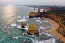
A stack or sea stack is a geological landform consisting of a steep and often vertical column or columns of rock in the sea near a coast, formed by wave erosion. [1] Stacks are formed over time by wind and water, processes of coastal geomorphology. [2] They are formed when part of a headland is eroded by hydraulic action, which is the force of the sea or water crashing against the rock. The force of the water weakens cracks in the headland, causing them to later collapse, forming free-standing stacks and even a small island. Without the constant presence of water, stacks also form when a natural arch collapses under gravity, due to sub-aerial processes like wind erosion. Erosion causes the arch to collapse, leaving the pillar of hard rock standing away from the coast—the stack. Eventually, erosion will cause the stack to collapse, leaving a stump. Stacks can provide important nesting locations for seabirds, and many are popular for rock climbing.

Contents

Isolated steep-sided, rocky oceanic islets typically of volcanic origin, are also loosely called "stacks" or "volcanic stacks".

Formation

Downpatrick Head, County Mayo, Ireland. Clear horizontal bedding is visible, exposing 350 million years of geological formation Downpatrick Head 2021.jpg
Downpatrick Head, County Mayo, Ireland. Clear horizontal bedding is visible, exposing 350 million years of geological formation

Stacks typically form in horizontally bedded sedimentary or volcanic rocks, particularly on limestone cliffs. The medium hardness of these rocks means medium resistance to abrasive and attritive erosion. A more resistant layer may form a capstone. (Cliffs with weaker rock, such as claystone or highly jointed rock, tend to slump and erode too quickly to form stacks, while harder rocks such as granite erode in different ways.) [4]

The formation process usually begins when the sea attacks lines of weakness, such as steep joints or small fault zones in a cliff face. These cracks then gradually get larger and turn into caves. If a cave wears through a headland, an arch forms. Further erosion causes the arch to collapse, leaving the pillar of hard rock standing away from the coast, the stack. Eventually, erosion will cause the stack to collapse, leaving a stump. This stump usually forms a small rock island, low enough for a high tide to submerge.

See also

Related Research Articles

<span class="mw-page-title-main">Tor (rock formation)</span> Large, free-standing rock outcrop on a gentle hill summit

A tor, which is also known by geomorphologists as either a castle koppie or kopje, is a large, free-standing rock outcrop that rises abruptly from the surrounding smooth and gentle slopes of a rounded hill summit or ridge crest. In the South West of England, the term is commonly also used for the hills themselves – particularly the high points of Dartmoor in Devon and Bodmin Moor in Cornwall.

<span class="mw-page-title-main">Natural arch</span> Arch-shaped natural rock formation

A natural arch, natural bridge, or rock arch is a natural landform where an arch has formed with an opening underneath. Natural arches commonly form where inland cliffs, coastal cliffs, fins or stacks are subject to erosion from the sea, rivers or weathering.

<span class="mw-page-title-main">Coastal erosion</span> Displacement of land along the coastline

Coastal erosion is the loss or displacement of land, or the long-term removal of sediment and rocks along the coastline due to the action of waves, currents, tides, wind-driven water, waterborne ice, or other impacts of storms. The landward retreat of the shoreline can be measured and described over a temporal scale of tides, seasons, and other short-term cyclic processes. Coastal erosion may be caused by hydraulic action, abrasion, impact and corrosion by wind and water, and other forces, natural or unnatural.

<span class="mw-page-title-main">Jurassic Coast</span> World Heritage Site on the coast of southern England

The Jurassic Coast is a World Heritage Site on the English Channel coast of southern England. It stretches from Exmouth in East Devon to Studland Bay in Dorset, a distance of about 96 miles (154 km), and was inscribed on the World Heritage List in mid-December 2001.

Landforms are categorized by characteristic physical attributes such as their creating process, shape, elevation, slope, orientation, rock exposure, and soil type.

<span class="mw-page-title-main">Mesa</span> Elevated area of land with a flat top and sides

A mesa is an isolated, flat-topped elevation, ridge or hill, which is bounded from all sides by steep escarpments and stands distinctly above a surrounding plain. Mesas characteristically consist of flat-lying soft sedimentary rocks capped by a more resistant layer or layers of harder rock, e.g. shales overlain by sandstones. The resistant layer acts as a caprock that forms the flat summit of a mesa. The caprock can consist of either sedimentary rocks such as sandstone and limestone; dissected lava flows; or a deeply eroded duricrust. Unlike plateau, whose usage does not imply horizontal layers of bedrock, e.g. Tibetan Plateau, the term mesa applies exclusively to the landforms built of flat-lying strata. Instead, flat-topped plateaus are specifically known as tablelands.

<span class="mw-page-title-main">Hoodoo (geology)</span> Tall, thin spire of relatively soft rock usually topped by harder rock

A hoodoo is a tall, thin spire of rock formed by erosion. Hoodoos typically consist of relatively soft rock topped by harder, less easily eroded stone that protects each column from the elements. They generally form within sedimentary rock and volcanic rock formations.

<span class="mw-page-title-main">Ridge</span> Long, narrow, elevated landform

A ridge is a long, narrow, elevated geomorphologic landform, structural feature, or a combination of both separated from the surrounding terrain by steep sides. The sides of a ridge slope away from a narrow top, the crest or ridgecrest, with the terrain dropping down on either side. The crest, if narrow, is also called a ridgeline. Limitations on the dimensions of a ridge are lacking. Its height above the surrounding terrain can vary from less than a meter to hundreds of meters. A ridge can be either depositional, erosional, tectonic, or a combination of these in origin and can consist of either bedrock, loose sediment, lava, or ice depending on its origin. A ridge can occur as either an isolated, independent feature or part of a larger geomorphological and/or structural feature. Frequently, a ridge can be further subdivided into smaller geomorphic or structural elements.

<span class="mw-page-title-main">Old Harry Rocks</span> Coastal chalk formations in Dorset, England

Old Harry Rocks are three chalk formations, including a stack and a stump, located at Handfast Point, on the Isle of Purbeck in Dorset, southern England. They mark the most eastern point of the Jurassic Coast, a UNESCO World Heritage Site.

<span class="mw-page-title-main">Coastal geography</span> Study of the region between the ocean and the land

Coastal geography is the study of the constantly changing region between the ocean and the land, incorporating both the physical geography and the human geography of the coast. It includes understanding coastal weathering processes, particularly wave action, sediment movement and weather, and the ways in which humans interact with the coast.

<span class="mw-page-title-main">Headward erosion</span> The Geographical processes of the Earth

Headward erosion is erosion at the origin of a stream channel, which causes the origin to move back away from the direction of the stream flow, lengthening the stream channel. It can also refer to the widening of a canyon by erosion along its very top edge, when sheets of water first enter the canyon from a more roughly planar surface above it, such as at Canyonlands National Park in Utah. When sheets of water on a roughly planar surface first enter a depression in it, this erodes the top edge of the depression. The stream is forced to grow longer at the very top of the stream, which moves its origin back, or causes the canyon formed by the stream to grow wider as the process repeats. Widening of the canyon by erosion inside the canyon, below the canyon side top edge, or origin or the stream, such as erosion caused by the streamflow inside it, is not called headward erosion.

<span class="mw-page-title-main">Sea cave</span> Cave formed by the wave action of the sea and located along present or former coastlines

A sea cave, also known as a littoral cave, is a type of cave formed primarily by the wave action of the sea. The primary process involved is erosion. Sea caves are found throughout the world, actively forming along present coastlines and as relict sea caves on former coastlines. Some of the largest wave-cut caves in the world are found on the coast of Norway, but are now 100 feet or more above present sea level. These would still be classified as littoral caves. By contrast, in places like Thailand's Phang Nga Bay, solutionally formed caves in limestone have been flooded by the rising sea and are now subject to littoral erosion, representing a new phase of their enlargement.

Beach evolution occurs at the shoreline where sea, lake or river water is eroding the land. Beaches exist where sand accumulated from centuries-old, recurrent processes that erode rocky and sedimentary material into sand deposits. River deltas deposit silt from upriver, accreting at the river's outlet to extend lake or ocean shorelines. Catastrophic events such as tsunamis, hurricanes, and storm surges accelerate beach erosion.

<span class="mw-page-title-main">Achilles Point</span>

Achilles Point is a rocky point on the headland at the eastern end of the small sandy beach named Ladies Bay, Auckland, New Zealand. The name 'Te Pane o Horoiwi' can also sometimes refer to the whole headland between St Heliers and Tamaki River estuary. Achilles Point is named after a ship called HMNZS Achilles (70) which defeated the German pocket battleship Admiral Graf Spee in 1939. The headland, from the point round to the Tamaki heads, was previously known as Te Pane o Horoiwi, named after Horoiwi who arrived in New Zealand on the Tainui canoe (waka).

<span class="mw-page-title-main">Cliffed coast</span> Coast where waves have formed steep cliffs

A cliffed coast, also called an abrasion coast, is a form of coast where the action of marine waves has formed steep cliffs that may or may not be precipitous. It contrasts with a flat or alluvial coast.

<span class="mw-page-title-main">The Pinnacles (Dorset)</span>

The Pinnacles are two chalk formations, including a stack and a stump, located near Handfast Point, on the Isle of Purbeck in Dorset, southern England.

<span class="mw-page-title-main">Scarp retreat</span>

Scarp retreat is a geological process through which the location of an escarpment changes over time. Typically the cliff is undermined, rocks fall and form a talus slope, the talus is chemically or mechanically weathered and then removed through water or wind erosion, and the process of undermining resumes. Scarps may retreat for tens of kilometers in this way over relatively short geological time spans, even in arid locations.

A fin is a geological formation that is a narrow, residual wall of hard sedimentary rock that remains standing after surrounding rock has been eroded away along parallel joints or fractures. Fins are formed when a narrow butte or plateau develops many vertical, parallel cracks. There are two main modes of following erosion. The first is when water flows along joints and fractures and opens them wider and wider, eventually causing erosion. The second is where the rock type (stratum) is harder and more erosion resistant than neighboring rocks, causing the weaker rock to fall away.

<span class="mw-page-title-main">Cheung Chau Mini Great Wall</span> Hiking trail in New Territories, Hong Kong

The Mini Great Wall or Little Great Wall is a hiking trail on Cheung Chau, an island of Hong Kong.

<span class="mw-page-title-main">Pancake Rocks and Blowholes</span> Coastal rock formation in New Zealand

The Pancake Rocks and Blowholes are a coastal rock formation at Punakaiki on the West Coast of the South Island of New Zealand. They are a popular visitor attraction.

References

  1. Easterbrook, D. J. (1999). Surface Processes and Landforms. Upper Saddle River, New Jersey: Prentice Hall. p. 442. ISBN   0-13-860958-6.
  2. "Sea stacks" britannica.com Archived 2009-04-14 at the Wayback Machine
  3. "Mayo - County Geological Site Report" (PDF). Geoheritage. Geological Survey of Ireland . Retrieved 28 December 2023.
  4. Schwartz, Maurice, ed. (2006). Encyclopedia of Coastal Science. Springer Science & Business Media. p. 238. ISBN   9781402038808.