An estuary is a partially enclosed coastal body of brackish water with one or more rivers or streams flowing into it, and with a free connection to the open sea. Estuaries form a transition zone between river environments and maritime environments and are an example of an ecotone. Estuaries are subject both to marine influences such as tides, waves, and the influx of saline water, and to fluvial influences such as flows of freshwater and sediment. The mixing of seawater and freshwater provides high levels of nutrients both in the water column and in sediment, making estuaries among the most productive natural habitats in the world.

A wetland is a distinct semi-aquatic ecosystem whose groundcovers are flooded or saturated in water, either permanently, for years or decades, or only seasonally. Flooding results in oxygen-poor (anoxic) processes taking place, especially in the soils. Wetlands form a transitional zone between waterbodies and dry lands, and are different from other terrestrial or aquatic ecosystems due to their vegetation's roots having adapted to oxygen-poor waterlogged soils. They are considered among the most biologically diverse of all ecosystems, serving as habitats to a wide range of aquatic and semi-aquatic plants and animals, with often improved water quality due to plant removal of excess nutrients such as nitrates and phosphorus.
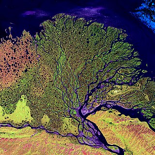
A river delta is a triangular landform created by the deposition of the sediments that are carried by the waters of a river, where the river merges with a body of slow-moving water or with a body of stagnant water. The creation of a river delta occurs at the river mouth, where the river merges into an ocean, a sea, or an estuary, into a lake, a reservoir, or into another river that cannot carry away the sediment supplied by the feeding river. Etymologically, the term river delta derives from the triangular shape (Δ) of the uppercase Greek letter delta. In hydrology, the dimensions of a river delta are determined by the balance between the watershed processes that supply sediment and the watershed processes that redistribute, sequester, and export the supplied sediment into the receiving basin.

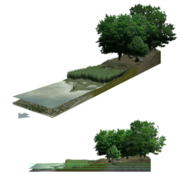
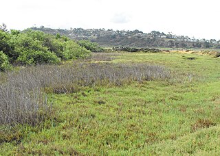
In ecology, a marsh is a wetland that is dominated by herbaceous plants rather than by woody plants. More in general, the word can be used for any low-lying and seasonally waterlogged terrain. In Europe and in agricultural literature low-lying meadows that require draining and embanked polderlands are also referred to as marshes or marshland.

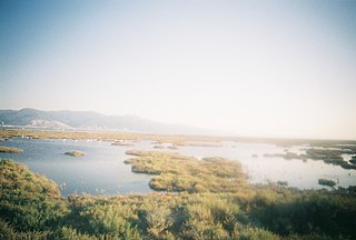
A salt marsh, saltmarsh or salting, also known as a coastal salt marsh or a tidal marsh, is a coastal ecosystem in the upper coastal intertidal zone between land and open saltwater or brackish water that is regularly flooded by the tides. It is dominated by dense stands of salt-tolerant plants such as herbs, grasses, or low shrubs. These plants are terrestrial in origin and are essential to the stability of the salt marsh in trapping and binding sediments. Salt marshes play a large role in the aquatic food web and the delivery of nutrients to coastal waters. They also support terrestrial animals and provide coastal protection.

Coos Bay is an estuary where the Coos River enters the Pacific Ocean, the estuary is approximately 12 miles long and up to two miles wide. It is the largest estuary completely within Oregon state lines. The Coos Bay watershed covers an area of about 600 square miles and is located in northern Coos County, Oregon, in the United States. The Coos River, which begins in the Oregon Coast Range, enters the bay from the east. From Coos River, the bay forms a sharp loop northward before arching back to the south and out to the Pacific Ocean. Haynes Inlet enters the top of this loop. South Slough branches off from the bay directly before its entrance into the Pacific Ocean. The bay was formed when sea levels rose over 20,000 years ago at the end of the Last Glacial Maximum, flooding the mouth of the Coos River. Coos Bay is Oregon's most important coastal industrial center and international shipping port, with close ties to San Francisco, the Columbia River, Puget Sound and other major ports of the Pacific rim.

A tidal creek or tidal channel is a narrow inlet or estuary that is affected by the ebb and flow of ocean tides. Thus, it has variable salinity and electrical conductivity over the tidal cycle, and flushes salts from inland soils. Tidal creeks are characterized by slow water velocity, resulting in buildup of fine, organic sediment in wetlands. Creeks may often be a dry to muddy channel with little or no flow at low tide, but with significant depth of water at high tide. Due to the temporal variability of water quality parameters within the tidally influenced zone, there are unique biota associated with tidal creeks which are often specialised to such zones. Nutrients and organic matter are delivered downstream to habitats normally lacking these, while the creeks also provide access to inland habitat for salt-water organisms.
An aquatic ecosystem is an ecosystem found in and around a body of water, in contrast to land-based terrestrial ecosystems. Aquatic ecosystems contain communities of organisms—aquatic life—that are dependent on each other and on their environment. The two main types of aquatic ecosystems are marine ecosystems and freshwater ecosystems. Freshwater ecosystems may be lentic ; lotic ; and wetlands.

Mangrove forests, also called mangrove swamps, mangrove thickets or mangals, are productive wetlands that occur in coastal intertidal zones. Mangrove forests grow mainly at tropical and subtropical latitudes because mangrove trees cannot withstand freezing temperatures. There are about 80 different species of mangroves, all of which grow in areas with low-oxygen soil, where slow-moving waters allow fine sediments to accumulate.

The wetlands of Louisiana are water-saturated coastal and swamp regions of southern Louisiana, often called "Bayou".
A tidal river is a river whose flow and level are caused by tides. A section of a larger river affected by the tides is a tidal reach, but it may sometimes be considered a tidal river if it had been given a separate and another title name.

Marine ecosystems are the largest of Earth's aquatic ecosystems and exist in waters that have a high salt content. These systems contrast with freshwater ecosystems, which have a lower salt content. Marine waters cover more than 70% of the surface of the Earth and account for more than 97% of Earth's water supply and 90% of habitable space on Earth. Seawater has an average salinity of 35 parts per thousand of water. Actual salinity varies among different marine ecosystems. Marine ecosystems can be divided into many zones depending upon water depth and shoreline features. The oceanic zone is the vast open part of the ocean where animals such as whales, sharks, and tuna live. The benthic zone consists of substrates below water where many invertebrates live. The intertidal zone is the area between high and low tides. Other near-shore (neritic) zones can include mudflats, seagrass meadows, mangroves, rocky intertidal systems, salt marshes, coral reefs, lagoons. In the deep water, hydrothermal vents may occur where chemosynthetic sulfur bacteria form the base of the food web.
Brackish marshes develop from salt marshes where a significant freshwater influx dilutes the seawater to brackish levels of salinity. This commonly happens upstream from salt marshes by estuaries of coastal rivers or near the mouths of coastal rivers with heavy freshwater discharges in the conditions of low tidal ranges.

High marsh is a tidal marsh zone located above the Mean Highwater Mark (MHW) which, in contrast to the low marsh zone, is inundated infrequently during periods of extreme high tide and storm surge associated with coastal storms. This zone is impacted by spring tides, which is a bi-monthly lunar occurrence where the high marsh experiences higher inundation levels. The high marsh is the intermittent zone between the low marsh and the uplands, an entirely terrestrial area rarely flooded during events of extreme tidal action caused by severe coastal storms. The high marsh is distinguished from the low marsh by its sandy soil and higher elevation. The elevation of the high marsh allows this zone to be covered by the high tide for no more than an hour a day. With the soil exposed to air for long periods of time, evaporation occurs, leading to high salinity levels, up to four times that of sea water. Areas of extremely high salinity prohibit plant growth altogether. These barren sandy areas are known as "salt pans". Some cordgrass plants do survive here, but are stunted and do not reach their full size.
Low marsh is a tidal marsh zone located below the Mean Highwater Mark (MHM). Based on elevation, frequency of submersion, soil characteristics, vegetation, microbial community, and other metrics, salt marshes can be divided to into three distinct areas: low marsh, middle marsh/high marsh, and the upland zone. Low marsh is characterized as being flooded daily with each high tide, while remaining exposed during low tides.

Blue carbon is a concept within climate change mitigation that refers to "biologically driven carbon fluxes and storage in marine systems that are amenable to management". Most commonly, it refers to the role that tidal marshes, mangroves and seagrass meadows can play in carbon sequestration. These ecosystems can play an important role for climate change mitigation and ecosystem-based adaptation. However, when blue carbon ecosystems are degraded or lost, they release carbon back to the atmosphere, thereby adding to greenhouse gas emissions.
Estuary freshwater inflow is the freshwater that flows into an estuary. Other types of environmental flows include instream flow, the freshwater water flowing in rivers or streams, and estuary outflow, the outflow from an estuary to the ocean.

Coastal erosion in Louisiana is the process of steady depletion of wetlands along the state's coastline in marshes, swamps, and barrier islands, particularly affecting the alluvial basin surrounding the mouth of the Mississippi River. In the last century, coastal Louisiana has lost an estimated 4,833 square kilometers (1,866 sq mi) of land, approximately the size of Delaware's land area. Coast wide rates of wetland change have varied from −83.5 square kilometers (−32.2 sq mi) to −28.01 square kilometers (−10.81 sq mi) annually, with peak loss rates occurring during the 1970's. One consequence of coastal erosion is an increased vulnerability to hurricane storm surges, which affects the New Orleans metropolitan area and other communities in the region. The state has outlined a comprehensive master plan for coastal restoration and has begun to implement various restoration projects such as fresh water diversions, but certain zones will have to be prioritized and targeted for restoration efforts, as it is unlikely that all depleted wetlands can be rehabilitated.
Sedimentation enhancing strategies are environmental management projects aiming to restore and facilitate land-building processes in deltas. Sediment availability and deposition are important because deltas naturally subside and therefore need sediment accumulation to maintain their elevation, particularly considering increasing rates of sea-level rise. Sedimentation enhancing strategies aim to increase sedimentation on the delta plain primarily by restoring the exchange of water and sediments between rivers and low-lying delta plains. Sedimentation enhancing strategies can be applied to encourage land elevation gain to offset sea-level rise. Interest in sedimentation enhancing strategies has recently increased due to their ability to raise land elevation, which is important for the long-term sustainability of deltas.
The marsh organ is a collection of plastic pipes attached to a wooden framework that is placed in marshes to measure the effects of inundation time and flood frequency on the productivity of marsh vegetation. The information is used for scientific research purposes.