This article relies largely or entirely on a single source .(December 2020) |

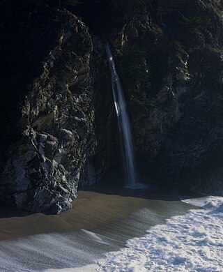
A coastal waterfall is a waterfall that plunges directly into the sea. Another common name for this feature is a tidefall.
This article relies largely or entirely on a single source .(December 2020) |
A coastal waterfall is a waterfall that plunges directly into the sea. Another common name for this feature is a tidefall.

Coastal waterfalls include:

A waterfall is any point in a river or stream where water flows over a vertical drop or a series of steep drops. Waterfalls also occur where meltwater drops over the edge of a tabular iceberg or ice shelf.

The Willamette Falls is a natural waterfall on the Willamette River between Oregon City and West Linn, Oregon, in the United States. It is the largest waterfall in the Northwestern United States by volume, and the seventeenth widest in the world. Horseshoe in shape, it is 1,500 feet (460 m) wide and 40 feet (12 m) high with a flow of 30,849 cu ft/s, located 26 miles (42 km) upriver from the Willamette's mouth. Willamette Falls is a culturally significant site for many tribal communities in the region.

Brontë Waterfall on the South Dean Beck is about a mile south-west of Stanbury, near Haworth in West Yorkshire, England. The area surrounding the waterfall is mainly moorland and farmland in Brontë Country, an area of outstanding beauty famous for its association with the Brontë sisters. Below the falls is Brontë Bridge, an old stone bridge across the beck. A flash flood in May 1989, swept the bridge away. In March 1990, a Lynx helicopter from No. 9 Regiment Army Air Corps, airlifted five gritstone slabs into the narrow valley to allow park rangers to repair the crossing.

Aysgarth Falls are a triple flight of waterfalls, surrounded by woodland and farmland, carved out by the River Ure over an almost one-mile (two-kilometre) stretch on its descent to mid-Wensleydale in the Yorkshire Dales of England, near the village of Aysgarth. The falls are quite spectacular after heavy rainfall as thousands of gallons of water cascade over the series of broad limestone steps, which are divided into three stages: Upper Force, Middle Force and Lower Force.

Uvas Canyon County Park is a 1,147-acre (464 ha) natural park located in upper Uvas Canyon on the eastern side of the Santa Cruz Mountains, west of Morgan Hill, California. The park has several small waterfalls, some of which flow perennially, that feed into tributaries confluent with Uvas Creek. The park is part of the Santa Clara County Parks System, and facilitates picnics, hiking and overnight camping. It is one of the few parks in the area that allows dogs in the campgrounds.

Hardraw Force is a waterfall on Hardraw Beck in Hardraw Scar, a wooded ravine just outside the hamlet of Hardraw, 0.9 miles (1.5 km) north of the town of Hawes, Wensleydale, in the Yorkshire Dales. The Pennine Way long distance footpath passes close by.

Wyke is a ward within the City of Bradford Metropolitan District Council in the county of West Yorkshire, England, named after the village of Wyke. The population taken at the 2011 Census was 14,958.

Trent Falls is the confluence of the River Ouse and the River Trent which forms the Humber between Lincolnshire and the East Riding of Yorkshire in England.

Barron Falls is a steep tiered cascade waterfall in Kuranda, Shire of Mareeba, Queensland, Australia. The falls are created by the Barron River descending from the Atherton Tablelands to the Cairns coastal plain.

The Hopetoun Falls is a waterfall across the Aire River that is located in the Otways region of Victoria, Australia.

The River Twiss is a river in the county of Yorkshire, England. The source of the river is Kingsdale Beck which rises at Kingsdale Head at the confluence of Back Gill and Long Gill in the Yorkshire Dales. Beneath Keld Head, it changes its name to the River Twiss. It has two notable waterfalls, Thornton Force and Pecca Falls, and its course follows part of the Ingleton Waterfalls Walk, then through Swilla Glen to Thornton in Lonsdale and down to Ingleton, where it meets the River Doe to form the River Greta.

The Cleveland Way is a National Trail in the historic area of Cleveland in North Yorkshire, Northern England. It runs 110 miles (177 km) between Helmsley and the Brigg at Filey, skirting the North York Moors National Park.

Ingleton Waterfalls Trail is a well-known circular trail beginning and ending in the village of Ingleton in the English county of North Yorkshire, now maintained by the Ingleton Scenery Company. It is claimed that the trail, some 8 kilometres (5 mi) long, and with a vertical rise of 169 m (554 feet) has some of the most spectacular waterfall and woodland scenery in the north of England. It is on private land and an entrance fee is charged.

Julia Pfeiffer Burns State Park is a state park in California, 12 miles south of Pfeiffer Big Sur State Park on California's Pacific coast. A main feature of the park is McWay Falls, which drops over a cliff of 80 feet (24 m) into the Pacific Ocean. The park is also home to 300-foot (90 m) redwoods which are over 2,500 years old. The park is named after Julia Pfeiffer Burns, a respected resident and rancher in the Big Sur region in the early 20th century, who lived in the area for much of her life until her death in 1928. The 3,762-acre (1,522 ha) park was established in 1962.

McWay Falls is an 80-foot-tall (24 m) waterfall on the coast of Big Sur in central California that flows year-round from McWay Creek in Julia Pfeiffer Burns State Park, about 37 miles (60 km) south of Carmel, into the Pacific Ocean. During high tide, it is a tidefall, a waterfall that empties directly into the ocean. The only other tidefall in California is Alamere Falls.
McWay Creek is a 2.5-mile-long (4.0 km) coastal stream in Monterey County in the U.S. state of California. It flows steeply west and south from McWay Canyon, high in California's Central Coast Range, and spills into the Pacific Ocean at Waterfall Cove after flowing over scenic McWay Falls. Most of the creek and its watershed are contained within Julia Pfeiffer Burns State Park, 12 miles (19 km) south of Pfeiffer Big Sur State Park. The creek is named after Christopher McWay from New York, a pioneer who homesteaded the property.

Phantom Falls or Coal Canyon Falls is a waterfall at Coal Canyon near Oroville, California, within the North Table Mountain Ecological Reserve. The waterfall is 166 feet (51 m) high and runs off the edge of Coal Canyon, in front of a grotto. A small pool at the bottom is home to a California newt subspecies, the Coastal Range newt. As a seasonal waterfall, Phantom Falls runs only during the rainy months, late autumn to early spring. It is named Phantom Falls because it disappears during the dry season.
Western River Wilderness Protection Area, formerly the Western River Conservation Park and the Western River National Park, is a protected area in the Australian state of South Australia located on the north coast of Kangaroo Island about 30 kilometres (19 mi) west of Parndana in the gazetted locality of Western River. Waterfall Creek, with its scenic Billy Goat Waterfall, are within the area.

Wyke Beck is a stream that runs from Roundhay Park to the River Aire in east Leeds, West Yorkshire, England. Described as an Urban Beck, the stream flows through housing estates and then an industrial landscape in its lower reaches. Wyke Beck has been prone to flooding so often, that remediation of its course and flood storage schemes have been initiated by Leeds City Council.
| | This article related to topography is a stub. You can help Wikipedia by expanding it. |

