Point Reyes National Seashore

Last updated

Point Reyes National Seashore
IUCN category V (protected landscape/seascape)
Chimney Rock Trail Point Reyes December 2016 panorama 1.jpg
Headlands of the Point Reyes Peninsula from Chimney Rock, looking north
Relief map of California.png
Red pog.svg
Usa edcp relief location map.png
Red pog.svg
Location Marin County, California, United States
Nearest city Point Reyes Station, California
Coordinates 38°4′N122°53′W / 38.067°N 122.883°W / 38.067; -122.883 [1]
Area71,028 acres (287.44 km2) [2]
EstablishedSeptember 13, 1962
Visitors2,336,202(in 2022) [3]
Governing body National Park Service
Website Point Reyes National Seashore

Point Reyes National Seashore is a 71,028-acre (287.44 km2) park preserve located on the Point Reyes Peninsula in Marin County, California. As a national seashore, it is maintained by the US National Park Service as an important nature preserve. Some existing agricultural uses are allowed to continue within the park. Clem Miller, a US Congressman from Marin County, wrote and introduced the bill for the establishment of Point Reyes National Seashore in 1962 to protect the peninsula from development which was proposed at the time for the slopes above Drake's Bay.

Contents

Geography

Point Reyes National Seashore Wpdms usgs photo point reyes national seashore.jpg
Point Reyes National Seashore

The Point Reyes peninsula is a well defined area, geologically separated from the rest of Marin County and almost all of the continental United States by a rift zone of the San Andreas Fault, [4] about half of which is sunk below sea level and forms Tomales Bay. The peninsula is part of the Salinian Block while across the fault is the Franciscan Complex; the difference in soil composition affects the mix of flora on either side of the fault.

The small town of Point Reyes Station, while not located on the peninsula, provides most services to it. Some services are also available at Inverness on the west shore of Tomales Bay. The small town of Olema, about 3 miles (4.8 km) south of Point Reyes Station, serves as the gateway to the Seashore and its visitor center.

The peninsula includes wild coastal beaches and headlands, estuaries, and uplands. Parts of the park are private farms and ranches which have commercial cattle grazing. These were leased back when the park was purchased to continue these historic uses. [5] Other parts are under the jurisdiction of other conservation authorities with the National Park Service providing signage and managing visitor impact on the entire peninsula and Tomales Bay. The Seashore also administers the parts of the Golden Gate National Recreation area, such as the Olema Valley, that are adjacent to the Seashore. [6]

Wildlife and ecology

Point Reyes National Seashore lies at the convergence of two marine ecological provinces (southern Oregonian and northern Californian) and harbors 45% of North America's bird species and 18% of California's plant species. The National Seashore's 100 miles (160 km) of coastline include estuaries, bays and lagoons which provide rich habitats including subtidal seagrasses, tidal mudflats and marshes that support a rich diversity of wildlife. [7]

Fauna

Tule Elk at Tomales Point Tupeelkpointreyes.jpg
Tule Elk at Tomales Point

The northernmost part of the peninsula is maintained as a reserve for tule elk (Cervus canadensis nannodes), an elk subspecies historically native to the region. Elk are readily seen there. [8] Although they had been completely extirpated from Point Reyes by the nineteenth century, in 1978, ten tule elk were reintroduced to Point Reyes from the San Luis National Wildlife Refuge near Los Banos. [9] By 2009, the population climbed to over 440 elk at Tomales Point's 2,600 acres (1,100 ha) of coastal scrub and grasslands. In 1999, 100 elk from Tomales Point were moved to the Limantour wilderness area of the Seashore and above Drakes Beach to Ranch A, as that ranch's long-term lease expired and was not renewed. [10] The drought in 2012–2015 was also a threat to the elk confined north of the fence on Tomales Point, with nearly half the elk there dying from lack of water. In 2012 there were 540 elk, then only 357 in 2013, and by 2014 only 286. [11] In August and September 2020, drought and wildfires again threaten the Tomales Point elk, leading some conservationists to illegally bring water to the elk north of the fence. [12] The Park Service began a public review and comment period in 2023 on a proposal remove of the tule elk fence with a final decision expected in the summer of 2024. [13]

The preserve is also very rich in raptors and shorebirds. [4] The western snowy plover that nests here is considered "threatened" under the Endangered Species Act. [14]

The Point Reyes Lighthouse attracts whale-watchers looking for the gray whale migrating south in mid-January and north in mid-March.

Elephant seal at Drakes Bay Elephantsealdrakesbeach.jpg
Elephant seal at Drakes Bay

Elephant seals were first observed in 1981 as they recolonized Chimney Beach, which is protected by 100-foot (30 m) cliffs. In January 2019, during the federal government shutdown, park rangers were not working and the seals had pups on Drakes Beach and its parking lot. [15] [16] Small-group tours to view the seals from the edge of the parking lot began the following month after the shutdown ended. [17] Docents help keep the public safe during the winter months as the colony continues to grow each year. [18]

Flora

Point Reyes lies within the California interior chaparral and woodlands ecoregion.

In his book The Natural History of the Point Reyes Peninsula, Jules Evens identifies several plant communities. One of the most prominent is the Coastal Douglas-fir (Pseudotsuga menziesii) forest, which includes Coast live oak, Tanoak, and California bay and reaches across the southern half of Inverness Ridge toward Bolinas Lagoon. Unlogged parts of this Douglas-fir forest contain trees over 300 years old and up to 6 feet (1.8 m) in diameter. But despite these large, old trees, the forest may nevertheless be a result of European settlement. The Coast Miwok people who once lived in the area set frequent fires to clear brush and increase game animal populations, and early explorers' accounts describe the hills as bare and grassy. But as the Native American settlements were replaced by European ones from the seventeenth century onward, the forests expanded as fire frequency decreased, resulting in the forests we see today. [19]

The Bishop pine (Pinus muricata) forest is found on slopes in the northern half of the park. Many of these trees growing in thick swaths came from seeds released after the 1995 Mt. Vision fire.

Salt, brackish, and freshwater marshlands are found adjacent to Drakes Estero and Abbotts Lagoon. The other communities identified by Evens are the coastal strand, dominated by European beach grass ( Ammophila arenaria ), ice plant (Carprobrotus edulis, also called sea fig or Hottentot fig), sea rocket (Cakile maritima) and other species that thrive on the immediate coast; northern coastal prairie, found on a narrow strip just inland from the coastal strand that includes some native grasses; coastal rangeland, the area still grazed by the cattle from the peninsula's remaining working ranches; [20] northern coastal scrub, dominated by coyote bush (Baccharis pilularis); and the intertidal and subtidal plant communities.

Point Reyes is home to the only known population of the endangered Sonoma spineflower, Chorizanthe valida . [21]

Cattle ranches

The park has 28,000 acres (11,000 ha) of dairy and beef cattle ranching. [22] Extremely high levels of fecal coliform bacteria ( Escherichia coli ) concentrations have been documented in streams adjacent to existing dairy operations. Cattle manure spreading areas are correlated with the increased presence of invasive and noxious weed species. Tomales Bay, Drakes Estero and Abbotts Lagoon are all affected by E. coli discharges from cattle operations in rainy winter months. [7] A joint inspection in 2022 by the Marin County Environmental Health Services and the National Park Service found the ranches were discharging raw sewage either through leaks or missing septic systems. [23]

Climate

Fog rolling in from the Pacific at Point Reyes National Seashore. Point Reyes Fog.JPG
Fog rolling in from the Pacific at Point Reyes National Seashore.
Point Reyes National Seashore
Climate chart (explanation)
J
F
M
A
M
J
J
A
S
O
N
D
 
 
112
 
 
12
4
 
 
109
 
 
13
4
 
 
121
 
 
16
6
 
 
51
 
 
16
6
 
 
1
 
 
19
8
 
 
10
 
 
19
10
 
 
1
 
 
21
11
 
 
4
 
 
23
11
 
 
17
 
 
24
11
 
 
31
 
 
21
10
 
 
133
 
 
15
7
 
 
178
 
 
12
4
Average max. and min. temperatures in °C
Precipitation totals in mm
Source: [24]
Imperial conversion
JFMAMJJASOND
 
 
4.4
 
 
54
39
 
 
4.3
 
 
55
39
 
 
4.8
 
 
61
43
 
 
2
 
 
61
43
 
 
0
 
 
66
46
 
 
0.4
 
 
66
50
 
 
0
 
 
70
52
 
 
0.2
 
 
73
52
 
 
0.7
 
 
75
52
 
 
1.2
 
 
70
50
 
 
5.2
 
 
59
45
 
 
7
 
 
54
39
Average max. and min. temperatures in °F
Precipitation totals in inches

Landmarks and facilities

View to the southeast from Chimney Rock Trail Chimney Rock Trail Point Reyes December 2016 panorama 2.jpg
View to the southeast from Chimney Rock Trail

The Point Reyes Lifeboat Station is a National Historic Landmark. It is the last remaining example of a rail-launched lifeboat station that was common on the Pacific coast.

Nova Albion, Francis Drake's 1579 campsite; Sebastião Rodrigues Soromenho's 1595 wreck; and fifteen associated Native American sites are included in the Drakes Bay Historic and Archaeological District National Historic Landmark. This encompasses 5,965 acres (24.14 km2) along the coast of Drakes Bay. [25]

Kule Loklo, a re-created Coast Miwok village, is a short walk from the visitor center.

Lairds Landing was the site of a wharf on the southwest shore of Tomales Bay. [26] It was named after ranchers, Charles and George Laird, who leased the site in 1858 to transport supplies and produce across the bay. [26] The location was settled by the Felix family around 1861, a family of Filipino and Miwok heritage. [27] After the descendants of the Felix family left in 1955, the land was zoned for development, then made part of the Point Reyes National Seashore, before becoming home to artist Clayton Lewis. [28] In 2015, structures built by the Felix family were placed on the National Register of Historic Places. [29]

More than 30,000 acres (120 km2) of the Point Reyes National Seashore are designated as the Phillip Burton Wilderness, named in honor of California Congressman Phillip Burton, who wrote the legislation creating the Golden Gate National Recreation Area and was instrumental in helping to pass the California Wilderness Act of 1984.

The Point Reyes National Seashore attracts 2.5 million visitors annually. Hostelling International USA (part of Hostelling International) maintains a 45-bed youth hostel at the Seashore. [30]

The Point Reyes National Seashore Association, formed in 1964, collaborates with the Seashore on maintenance, restoration and educational projects. [31]

Hiking

A group of people gathered to watch the sunset at Point Reyes National Seashore. People watching sunset at Point Reyes National Seashore.jpg
A group of people gathered to watch the sunset at Point Reyes National Seashore.

Point Reyes has a system of hiking trails for dayhiking and backpacking. Bear Valley Trail is the most popular hike in the park. It travels mostly streamside through a shaded, fern-laden canyon, breaking out at Divide Meadow before heading downward to the coast, where it emerges at Arch Rock. A portion of Arch Rock collapsed on March 21, 2015, killing one person. [32]

A US National Geodetic Survey marker at the peak of Mt. Wittenberg, the highest point in the park. U-S- National Geodetic Survey marker Mt- Wittenberg, Point Reyes National Seashore.jpg
A US National Geodetic Survey marker at the peak of Mt. Wittenberg, the highest point in the park.

Three trails connecting from the west with the Bear Valley trail head upward toward Mount Wittenberg, at 1,407 feet (429 m), the highest point in the park. [4] The Earthquake Trail, a 0.6-mile (0.97 km) loop that runs over the San Andreas Fault. The trail provides descriptions of the fault and the surrounding geology, and features a fence that was pulled 18 feet (5.5 m) apart during the 1906 San Francisco earthquake. [33]

At the western end of the Point Reyes Peninsula is the historic Point Reyes Lighthouse, reached by descending 308 steps. Unlike many lighthouses, that were built high so the light could be seen by ships far out to sea, the Point Reyes lighthouse was built low to get the light below the fog that is so prevalent in the area. Nearby is the short Chimney Rock hike, which is noted for its spring wildflower displays. [4]

Point Reyes offers several beach walks. Limantour Spit winds up on a narrow sandy beach, from which Drakes Beach can be glimpsed across Drakes Bay. North Beach and South Beach are often windswept and wave-pounded. Ocean vistas from higher ground can be seen from the Tomales Point Trail and, to the south, from the Palomarin trailhead at the park's southern entrance outside the town of Bolinas. All of the park's beaches were listed as the cleanest in the state in 2010. [34]

For backpackers, Point Reyes has four hike-in campgrounds available by reservation.

Point Reyes is a terminus of the American Discovery Trail which is the only transcontinental trail in the United States. [35]

Marine Protected Areas

Point Reyes State Marine Reserve & Point Reyes State Marine Conservation Area, Estero de Limantour State Marine Reserve & Drakes Estero State Marine Conservation Area and Duxbury Reef State Marine Conservation Area adjoin Point Reyes National Seashore. These marine protected areas help conserve ocean wildlife and marine ecosystems.

Oyster farm

Point Reyes National Shoreline 2018 Point Reyes National Shoreline.jpg
Point Reyes National Shoreline 2018

A large oyster farm was located in Drakes Estero until, under court order, it closed down at end of 2014. Court appeals to keep the operation in place were dropped in December, 2014. [36]

The farm was purchased by the National Park Service in 1972, and the agency issued a permit to allow the previous owner to continue operations for 40 years. The business was sold to a new owner in 2004, the Drakes Bay Oyster Company, who was informed by the NPS at the time of purchase that their permit to operate would not be renewed beyond the November 30, 2012 expiration date. [37] A federal law enacted in 2009 authorized, but did not require, Interior Secretary Ken Salazar to renew the permit. [38] The NPS and conservation groups viewed the farm as an inappropriate and environmentally-insensitive use of the estero, which was designated a "potential wilderness area" by Congress. The farm's supporters argued that it was not ecologically harmful and was important to the local economy. [38] [39]

On November 29, 2012, Salazar announced that he would not renew the permit, citing the original intent of the Point Reyes Wilderness Act to designate the area as wilderness upon the removal of the oyster farm. [37] Salazar visited the farm the previous week and later personally phoned the farm's owner to give him the news. [40]

The oyster farm closure was challenged in U.S. District Court on January 25, 2013. [41] The challenge was rejected by a federal court judge, who ruled that the law gave Salazar unfettered discretion to approve or deny a renewal of the permit. [42] The California Coastal Commission voted on February 7, 2013 to unanimously approve cease and desist and restoration orders for violations of the California Coastal Act. [43] The United States Court of Appeals for the Ninth Circuit rejected an appeal of the district court's decision, ruling on Sept. 3, 2013 that the oyster farm's owner had not shown a likelihood of success on the merits because Salazar had acted within his discretion in denying the permit. [44] An attempt to have the appeals court rehear the case was rejected on January 14, 2014 and a petition to the United States Supreme Court [45] was denied on June 30, 2014. [46] The oyster farm closed its on site retail operation on July 31, 2014. [47] [48] However, controversy continued over the condition of the estero sea floor and the ongoing off shore operations. [49] Another lawsuit challenging the closure itself was rejected in September 2014. [50] [51]

The work to remove the offshore racks and onshore buildings was completed in May 2017; 1,700 tonnes (1,700 long tons; 1,900 short tons) of debris had been hauled away. The estero is part of the Phillip Burton Wilderness. [52] [53]

See also

Related Research Articles

<span class="mw-page-title-main">Marin County, California</span> County in California, United States

Marin County is located in the northwestern part of the San Francisco Bay Area of the U.S. state of California. As of the 2020 census, the population was 262,231. Its county seat and largest city is San Rafael. Marin County is across the Golden Gate Bridge from San Francisco, and is included in the San Francisco–Oakland–Berkeley, CA Metropolitan Statistical Area.

<span class="mw-page-title-main">Inverness, California</span> Census-designated place in California, United States

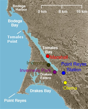
Inverness is an unincorporated community and census-designated place (CDP) in western Marin County, California, United States. It is located on the southwest shore of Tomales Bay 3.5 miles northwest of Point Reyes Station and about 40 miles (65 km) by road northwest of San Francisco, at an elevation of 43 feet. In the 2020 census, the population was 1,379. The community was named by a Scottish landowner after Inverness in Scotland.

<span class="mw-page-title-main">Point Reyes Station, California</span> Census-designated place in California, United States

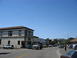
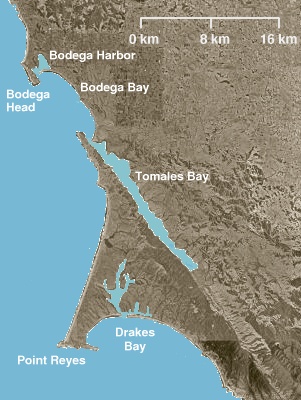
Point Reyes Station is a small unincorporated town in western Marin County, California, United States. Point Reyes Station is located 13 miles (21 km) south-southeast of Tomales, at an elevation of 39 feet (12 m). Point Reyes Station is located along State Route 1 and is a gateway to the Point Reyes National Seashore, an extremely popular national preserve. The Point Reyes Station census-designated place (CDP) covers the unincorporated town and adjacent development to the north, with a total population of 895 as of the 2020 census.

<span class="mw-page-title-main">Coast Miwok</span> Tribe of Native American people

The Coast Miwok are an Indigenous people of California that were the second-largest tribe of the Miwok people. Coast Miwok inhabited the general area of modern Marin County and southern Sonoma County in Northern California, from the Golden Gate north to Duncans Point and eastward to Sonoma Creek. Coast Miwok included the Bodega Bay Miwok, or Olamentko (Olamentke), from authenticated Miwok villages around Bodega Bay, the Marin Miwok, or Hookooeko (Huukuiko), and Southern Sonoma Miwok, or Lekahtewutko (Lekatuit). While they did not have an overarching name for themselves, the Coast Miwok word for people, Micha-ko, was suggested by A. L. Kroeber as a possible endonym, keeping with a common practice among tribal groups and the ethnographers studying them in the early 20th Century and with the term Miwok itself, which is the Central Sierra Miwok word for people.

<span class="mw-page-title-main">Drakes Bay</span> Bay on the coast of California, U.S.

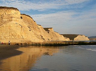
Drakes Bay is a 4 mi (6 km) wide bay named so by U.S. surveyor George Davidson in 1875 along the Point Reyes National Seashore on the coast of northern California in the United States, approximately 30 mi (50 km) northwest of San Francisco at approximately 38 degrees north latitude. The bay is approximately 8 mi (13 km) wide. It is formed on the lee side of the coastal current by Point Reyes. The bay is named after Sir Francis Drake and has long been considered Drake's most likely landing spot on the west coast of North America during his circumnavigation of the world by sea in 1579. An alternative name for this bay is Puerto De Los Reyes.

<span class="mw-page-title-main">Drakes Estero</span> Lagoon in California, United States

Drakes Estero is an expansive estuary in the Point Reyes National Seashore of Marin County on the Pacific coast of northern California in the United States, approximately 25 miles (40 km) northwest of San Francisco.

<span class="mw-page-title-main">Point Reyes</span> Cape in Northern California

Point Reyes is a prominent cape and popular Northern California tourist destination on the Pacific coast. Located in Marin County, it is approximately 30 miles (50 km) west-northwest of San Francisco. The term is often applied to the Point Reyes Peninsula, the region bounded by Tomales Bay on the northeast and Bolinas Lagoon on the southeast. The majority of the peninsula as well as the headlands are protected as part of Point Reyes National Seashore.

<span class="mw-page-title-main">Tomales Bay</span> Inlet of the Pacific Ocean in Marin County, California, US

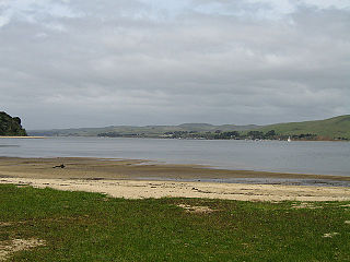
Tomales Bay is a long, narrow inlet of the Pacific Ocean in Marin County in northern California in the United States. It is approximately 15 mi (24 km) long and averages nearly 1.0 mi (1.6 km) wide, effectively separating the Point Reyes Peninsula from the mainland of Marin County. It is located approximately 30 mi (48 km) northwest of San Francisco. The bay forms the eastern boundary of Point Reyes National Seashore. Tomales Bay is recognized for protection by the California Bays and Estuaries Policy. On its northern end, it opens out onto Bodega Bay, which shelters it from the direct current of the Pacific. The bay is formed along a submerged portion of the San Andreas Fault.

<span class="mw-page-title-main">Hog Island (Tomales Bay)</span>

Hog Island is an island roughly 2 acres (0.8 ha) in size located approximately 5 mi (8 km) south of the entrance to Tomales Bay in the West Marin area of Marin County, California.

<span class="mw-page-title-main">Golden Gate Biosphere Network</span>

The Golden Gate Biosphere Network is a voluntary coalition of federal, state, and local government agencies, nonprofit organizations, universities, and private partners within the Golden Gate Biosphere region. The Network works towards protecting the biosphere region's biodiversity and conserving its natural resources to maintain the quality of life for people within the region. The Network has been part of the UNESCO Man and Biosphere Programme since 1988 and is part of the US Biosphere Network and EuroMAB. It is recognized by UNESCO due to the significant biodiversity of the region, as well as the Network's efforts to demonstrate and promote a balanced relationship between humans and the biosphere.

<span class="mw-page-title-main">Tomales Bay State Park</span> State park in California, United States

Tomales Bay State Park is a California state park in Marin County, California. It consists of approximately 2,000 acres (8 km²) divided between two areas, one on the west side of Tomales Bay and the other on the east side. The main area, on the west, is part of the Point Reyes peninsula, and adjacent to Point Reyes National Seashore, which is operated by the U.S. National Park Service. The park is approximately 40 miles (64 km) north of San Francisco.

<span class="mw-page-title-main">Inverness Park, California</span> Unincorporated community in California, United States

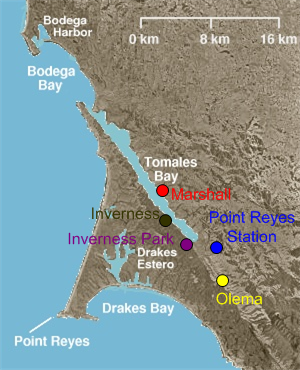
Inverness Park is a small unincorporated community in Marin County, California. It is located 1 mile (1.6 km) west-southwest of Point Reyes Station, at an elevation of 148 feet.

<span class="mw-page-title-main">Tule elk</span> Subspecies of mammal

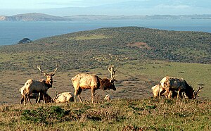
The tule elk is a subspecies of elk found only in California, ranging from the grasslands and marshlands of the Central Valley to the grassy hills on the coast. The subspecies name derives from the tule, a species of sedge native to freshwater marshes on which the Tule elk feeds. When the Europeans first arrived, an estimated 500,000 tule elk roamed these regions, but by 1870 they were thought to be extirpated. However, in 1874–1875 a single breeding pair was discovered in the tule marshes of Buena Vista Lake in the southern San Joaquin Valley. Conservation measures were taken to protect the species in the 1970s. Today, the wild population exceeds 4,000. Tule elk can reliably be found in Carrizo Plain National Monument, Point Reyes National Seashore, portions of the Owens Valley from Lone Pine to Bishop, on Coyote Ridge in Santa Clara Valley, San Jose, California and in Pacheco State Park and areas surrounding San Luis Reservoir near Los Banos, California.

<span class="mw-page-title-main">Phillip Burton Wilderness</span> Protected wilderness area in California, United States

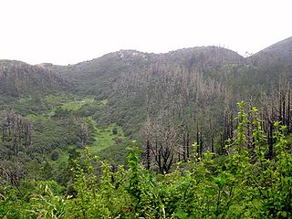
The Phillip Burton Wilderness is part of the 111 sq. mile (288 km2) Point Reyes National Seashore located about 20 miles (32 km) northeast of San Francisco, California. Total wilderness land is 33,373 acres which includes a roadless "potential wilderness" area of over 8,000 acres (32 km2) and is one of only three designated wilderness along the California coast, the others being the King Range Wilderness and the Rocks and Islands Wilderness. The National Park Service manages the wilderness.

<span class="mw-page-title-main">L. Martin Griffin</span>

L. Martin Griffin, widely known as Marty Griffin, is an American environmentalist and conservationist in Northern California and author of the book Saving the Marin–Sonoma Coast. He has also been a doctor, director of the Sonoma Developmental Center, head of the Marin Audubon Society, board member of the Marin Municipal Water District, and owner of Hop Kiln Winery in Sonoma County.

<span class="mw-page-title-main">Estero de Limantour State Marine Reserve & Drakes Estero State Marine Conservation Area</span> Marine conservation area in California, United States

Estero de Limantour State Marine Reserve (SMR) and Drakes Estero State Marine Conservation Area (SMCA) are two adjoining marine protected areas along the Point Reyes National Seashore in Marin County on California’s north central coast. These marine protected areas cover a combined 4.04 square miles (10.5 km2), with 1.49 square miles (3.9 km2) in the SMR and 2.55 square miles (6.6 km2) in the SMCA. Drakes Estero SMCA prohibits the take of all living marine resources from Drakes Estero except the recreational take of clams and formerly the commercial aquaculture of shellfish pursuant to a disputed state water bottom lease and permit, which has been the subject of ongoing legal proceedings since 2012, when the lease was allowed to expire.

Rancho Tomales y Baulines was a 9,468-acre (38.32 km2) Mexican land grant in present-day Marin County, California, given in 1836 by Governor Nicolás Gutiérrez to Rafael Garcia. The grant extended south from Point Reyes Station along the Olema Valley and encompassed present day Olema and Garcia.

<span class="mw-page-title-main">Tomales Point</span> Headland in California, United States

Tomales Point is the North-Western tip of Point Reyes Peninsula. Bodega Bay is to the North, Tomales Bay is to the East, and the Pacific Ocean is to the West. The point is accessible only via a 9.5 mile hike along Tomales Point Trail. The region is home to a tule elk population.

<span class="mw-page-title-main">Drakes Bay Oyster Company</span>

Drakes Bay Oyster Company was an oyster farm and restaurant formerly located at the shoreline and in Drakes Estero at 38°04'57.3"N 122°55'55.0"W, a bay within Point Reyes National Seashore, on the West Marin coast of Marin County, in Northern California. In 2011, the lease for the business operation was not renewed at the direction of the United States Secretary of the Interior. After a two-year court battle, the business was terminated in December 2014, and Drakes Estero was cleared of the offshore racks and onshore structures, with the work completed in 2017.

<span class="mw-page-title-main">Camp Hydle</span> Former United States Navy Base

Camp Hydle also called Drakes Bay Range was a large training center during World War II, located at Drakes Bay, on what is now Point Reyes National Seashore on the coast of northern California in the United States. The camp had several training sites: Camp Hydle, Drakes Bay Air to Ground Gunnery Range, Drakes Bay Dive Bombing Target, Camp Murphy's Ranch, Camp Hydle Maneuver Area, and Camp Hydle Skip and Dive Bombing Range. Also at the camp were landing craft training and air sea rescue training. The site was 10,532 acres of Marin County, California land on the West Coast of the United States. The complete area from Stinson Beach to the south and Dillon Beach to the north was called the Point Reyes Gunnery Range at Point Reyes. The Gunnery Range also included: two radar towers, horse stable, two lifeboat Stations, the Point Reyes Lighthouse, lookout towers, and land strafing targets (rake). The dive bomber airplanes came from Hamilton Army Airfield (AAF), Santa Rosa Army Airfield (AAF), and Naval Air Station Alameda (NAS). In addition to Drakes Bay the planes also training using the nearby Abbotts Lagoon, and Tomales Bay. The landing craft training used Limantour Beach and Limantour Spit. Anti-aircraft gun training was important training for the Pacific War. Camp Hydle base was inland 1/2 mile east of Limantour Beach. For gunner training planes towed targets across Drakes Bay. Ships also trained at the base, like the USS Walton and USS Nevada (BB-36). The Navy's Camp Hydle took over the Point Reyes Lifeboat Station during the war. The 50 men at the Station were air sea rescue pilots, dropping rafts to plane crew that landed in the ocean during training. The first troops arrived at the site on December 7, 1941. The site was also used as a coast defense spot, looking out for Japanese subs and ships. Most of the land was leased from Leland Murphy, after the war in 1962, the site became Point Reyes National Seashore.

References

  1. "Point Reyes National Seashore". Geographic Names Information System . United States Geological Survey, United States Department of the Interior.
  2. "Listing of acreage – December 31, 2010" (XLSX). Land Resource Division, National Park Service. Retrieved July 13, 2011. (National Park Service Acreage Reports)
  3. "NPS Annual Recreation Visits Report". National Park Service. Retrieved July 23, 2023.
  4. 1 2 3 4 Point Reyes National Seashore Archived 2006-09-29 at the Wayback Machine , National Park Service, U.S. Department of the Interior
  5. Sabalow, Ryan (August 8, 2019). "Feds plan to kill elk at Point Reyes to protect ranches. Here's how you can weigh in". Sacramento Bee. Retrieved August 9, 2019.
  6. Houston, Will (September 19, 2020). "Point Reyes releases final plan to preserve ranches, cull tule elk". Marin Independent Journal. Retrieved September 20, 2020.
  7. 1 2 Anitra Pawley; Mui Lay (March 1, 2013). Coastal Watershed Assessment for Golden Gate National Recreation Area and Point Reyes National Seashore Natural Resource Report NPS/PWR/NRR—2013/641 (PDF) (Report). U.S. Department of the Interior National Park Service. Retrieved May 7, 2021.
  8. Post, Charles (March 19, 2015). "A Brief History of Tule Elk on the Point Reyes Peninsula". Marin Coast Guide. Archived from the original on February 10, 2016.
  9. Linse, Kim (1998). "Tule Elk: The Return of a Species" (PDF). Point Reyes National Seashore. National Park Service. Archived (PDF) from the original on October 17, 2013.
  10. "Tule Elk". National Park Service . Retrieved September 5, 2011.
  11. "Drought Likely Cause of Death for 250 Native Elk At Point Reyes National Seashore". AP Press. April 16, 2015. Retrieved September 2, 2020.
  12. Deborah Moskowitz. "Drought and Wildfire Threaten Tule Elk at Point Reyes National Seashore". Western Watersheds Project. Retrieved September 2, 2020.
  13. Ramos, John (June 19, 2023). "Activists, ranchers clash over proposed changes to Point Reyes nature preserve - CBS San Francisco". CBS News. Bay City News Service. Retrieved June 21, 2023.
  14. Valentino, Silas (June 2, 2022). "Access to Point Reyes beach denied so plover birds can thrive". SFGATE. Retrieved June 3, 2022.
  15. "Elephant seals take over beach at Point Reyes for the second time this year". Los Angeles Times. Associated Press. May 23, 2019. Retrieved May 24, 2019.
  16. Amy Graff (January 30, 2019). "Elephant seals took over a Pt. Reyes beach during shutdown. It won't reopen anytime soon". San Francisco Chronicle.
  17. "Beach taken over by elephant seals to reopen for viewing". San Francisco Chronicle. Associated Press. February 1, 2019.
  18. Harrell, Ashley (February 19, 2022). "Huge creatures are taking over a Point Reyes beach". SFGATE. Retrieved February 22, 2022.
  19. Brown, Peter M.; Kaye, Margot W.; Buckley, Dan (1999). "Fire History in Douglas-fir and Coast Redwood Forests at Point Reyes National Seashore, California" (PDF). Northwest Science. 73 (3): 205–216. Archived (PDF) from the original on May 15, 2008.
  20. Serna, Joseph (July 13, 2017). "Conservationists, National Park Service and Point Reyes ranchers reach settlement on disputed land". LA Times . Archived from the original on July 22, 2017. Retrieved July 23, 2017.
  21. CNPS Profile: Chorizanthe valida Archived 2012-04-23 at the Wayback Machine
  22. Houston, Will (September 14, 2021). "Point Reyes adopts controversial ranch, elk plan". Marin Independent Journal. Retrieved September 15, 2021.
  23. Houston, Will (September 7, 2022). "Point Reyes ranch inspections find more sewage leaks". Marin Independent Journal. Retrieved September 8, 2022.
  24. "NASA Earth Observations Data Set Index". NASA. Retrieved January 30, 2016.
  25. "National Historic Landmarks Program: National Park Service: Drakes Bay Historic and Archeological District" (PDF). Archived (PDF) from the original on February 22, 2014. Retrieved October 23, 2012.
  26. 1 2 Durham, David L. (1998). California's Geographic Names: A Gazetteer of Historic and Modern Names of the State. Clovis, Calif.: Word Dancer Press. p. 650. ISBN   1-884995-14-4.
  27. Christy Avery (2009). Tomales Bay Environmental History and Historical Resource Study (Report). United States Department of the Interior. Retrieved September 26, 2018.
  28. Curwen, Thomas (April 18, 2016). "Reminders of a bohemian artist's past will soon fade at Laird's Landing". Los Angeles Times. Retrieved September 26, 2018.
  29. Guth, Anna (September 20, 2018). "Restoration underway at Lairds Landing". Point Reyes Light. Retrieved September 26, 2018.
  30. Archived June 17, 2010, at the Wayback Machine
  31. "About Point Reyes National Seashore Association". Point Reyes National Seashore Association. Archived from the original on August 21, 2015. Retrieved August 9, 2015.
  32. "Hiker dies, another injured after cliff collapse in Point Reyes". Bay City News. March 22, 2015. Archived from the original on March 22, 2015 via San Francisco Chronicle.
  33. Trail Guide & Suggested Hikes - Point Reyes National Seashore Archived 2008-03-15 at the Wayback Machine . Nps.gov. Retrieved on 2013-07-21.
  34. Bay Area beaches grade well for safe swimming Archived 2010-06-22 at the Wayback Machine , May 27, 2010 by Carolyn Jones, San Francisco Chronicle
  35. "American Discovery Trail Society - the only coast-to-coast, non-motorized recreational trail for hiking, biking, riding". Archived from the original on August 1, 2015. Retrieved April 26, 2018. American Discovery Trail website retrieved October 21, 2010
  36. "Legal stand ends for Drakes Bay Oyster Co. supporters". marinij.com. Archived from the original on December 7, 2014. Retrieved May 3, 2018.
  37. 1 2 Secretary Salazar Issues Decision on Point Reyes National Seashore Permit Archived 2014-04-17 at the Wayback Machine , United States Department of the Interior, November 29, 2012
  38. 1 2 9th Circuit Mulls Fate of California Oyster Farm Archived 2014-12-08 at the Wayback Machine , Courthouse News Service, May 15, 2013.
  39. "Oyster farm battle" . Retrieved September 9, 2012.
  40. "Interior secretary denies renewal of oyster company lease on national seashore in California". Archived from the original on December 12, 2012. Retrieved November 29, 2012.
  41. "Drakes Bay attorneys argue for injunction to keep oyster operation open". Archived from the original on January 27, 2013. Retrieved January 27, 2013.
  42. "Federal judge declines to halt closure of Drakes Bay Oyster Co". Archived from the original on February 8, 2013. Retrieved February 4, 2013.
  43. Prado, Mark (February 8, 2013). "Point Reyes oyster farm dealt another setback". Marin Independent Journal. Archived from the original on May 30, 2013. Retrieved July 22, 2013.
  44. Appeals court deals blow to Drakes Bay Oyster Co. Archived 2013-09-04 at the Wayback Machine , Bob Egelko, San Francisco Chronicle , Sept. 3, 2013
  45. "Court denies Drakes Bay Oyster Co. petition to have its case reheard". Archived from the original on January 16, 2014. Retrieved January 14, 2014.
  46. "U.S. Supreme Court refuses to take Drakes Bay Case". Archived from the original on July 6, 2014. Retrieved June 30, 2014.
  47. Drakes Bay Oyster Co. to shut down this month per federal order Archived 2014-07-25 at the Wayback Machine , Mark Prado, Marin Independent Journal, July 10, 2014
  48. Cart, Julie (July 18, 2013). "Oyster farm must comply with California coastal laws, judge rules July 18, 2013". Los Angeles Times . Archived from the original on August 29, 2016. Retrieved August 20, 2016.
  49. "Trash, Invasive Species Left Behind as Controversial Oyster Farm Closes". kcet.org. August 20, 2014. Archived from the original on September 5, 2015. Retrieved May 3, 2018.
  50. "Court battle over Drakes Bay oyster farm set to resume". pressdemocrat.com. September 6, 2014. Archived from the original on December 22, 2017. Retrieved May 3, 2018.
  51. Kovner, Guy. Judge rejects firms’ bid to keep Drakes Bay Oyster Co. open Archived 2014-09-11 at the Wayback Machine , Santa Rosa Press-Democrat, 9 September 2014
  52. "Point Reyes estuary gets cleanup after 80 years of oyster farming". Santa Rosa Press Democrat. April 13, 2017. Archived from the original on January 6, 2018. Retrieved May 3, 2018.
  53. "Drakes Estero Restoration - Point Reyes National Seashore (U.S. National Park Service)". www.nps.gov. Archived from the original on March 17, 2018. Retrieved May 3, 2018.