Channel Islands National Marine Sanctuary

Last updated
Channel Islands National Marine Sanctuary
IUCN category V (protected landscape/seascape)
Orcas off Santa Rosa island.jpg
Relief map of California.png
Red pog.svg
Usa edcp relief location map.png
Red pog.svg
Coordinates 34°N120°W / 34°N 120°W / 34; -120
Area1,470 sq mi (3,800 km2)
Established1980
Governing body National Oceanic and Atmospheric Administration
www.cinms.nos.noaa.gov
Map of Channel Islands sanctuary Channel Islands NMS map.jpg
Map of Channel Islands sanctuary
Santa Barbara Maritime Museum Santa Barbara Maritime Museum.JPG
Santa Barbara Maritime Museum

The Channel Islands National Marine Sanctuary [1] is a sanctuary off the coast of Santa Barbara and Ventura counties in Southern California 350 miles south of San Francisco and 95 miles north of Los Angeles. It was designated in 1980 by the National Oceanic and Atmospheric Administration.

Contents

The sanctuary encompasses approximately 1,470 square miles of ocean waters around Anacapa, Santa Cruz, Santa Rosa, San Miguel and Santa Barbara Islands, extending from the mean high tide of these islands to six nautical miles offshore, and surrounding Channel Islands National Park. It is part of the National Marine Sanctuary program under the administration of the National Oceanic and Atmospheric Administration (NOAA). [2]

Its remote, isolated position at the confluence of two major ocean currents supports remarkable biodiversity and productivity. It's a special place for endangered species, sensitive habitats, historic shipwrecks, other maritime heritage artifacts, and living Chumash culture. Many valuable commercial and recreational activities thrive in the sanctuary, such as fishing, shipping, and tourism.

The sanctuary was federally designated because of its national significance as an area of exceptional natural beauty and resources, and due to heightened concerns following the 1969 oil spill in the Santa Barbara Channel. Protection of sanctuary resources is supported through research, education, conservation, and stewardship programs. The primary goal of the sanctuary is the protection of natural and cultural resources contained within its boundaries. The sanctuary is managed to promote ecosystem conservation, protect cultural resources, and support compatible human uses.

Education

"Los Marineros" is a marine education program for children founded by the CINMS in 1987 and administered by the Santa Barbara Museum of Natural History. Kids 300.jpg
"Los Marineros" is a marine education program for children founded by the CINMS in 1987 and administered by the Santa Barbara Museum of Natural History.
Marine life off Santa Cruz Island Channel Islands marine life.jpg
Marine life off Santa Cruz Island

The Channel Islands National Marine Sanctuary (CINMS) is dedicated to education and outreach aiming to promote understanding, support, and participation in the protection and conservation of marine resources. [3]

The sanctuary's visitor center works to interpret the living and maritime heritage resources that are a part of this iconic place. [4]

Outreach Products

The sanctuary distributes brochures and other resources such as posters, maps and coloring books for the public mostly informing about the biodiversity in the sanctuary as well as how to preserve it. [5]

Students at Sea

Program addressed to High Schools and college students. The objective is to explore different career pathways and learn how science is used to address different resource protection issues that threaten the health of our ocean. [6]

Teachers at See

Program addressed to elementary through high school teachers. They are involved in some hands-on activities such as conducting plankton tows, viewing plankton under a video microscope, piloting remotely operated vehicles, sampling water quality parameters such as pH and salinity and learning about current sanctuary research. The aim of the program is for these teachers to have the tools and resources to then pass them on to their students. [7]

Research

Channel Islands kelp forests off San Miguel and Santa Rosa islands. Kelp beds are difficult to spot in conventional color air photos but stand out clearly in this near-infrared image from Landsat data. Channel Islands kelp beds 2013.jpg
Channel Islands kelp forests off San Miguel and Santa Rosa islands. Kelp beds are difficult to spot in conventional color air photos but stand out clearly in this near-infrared image from Landsat data.

The sanctuary has partnerships with National Marine Fisheries Service, the National Park Service, and the Department of Fisheries and Oceans Canada, as well as regional and international academic institutions such as the University of California, Santa Barbara, Scripps Institution of Oceanography, Woods Hole Oceanographic Institution, Simon Fraser University, and the University of Auckland, New Zealand. These partnerships are facilitated by staff research expertise as well as operational support provided by the NOAA research vessels Shearwater and Shark Cat.

The sanctuary is currently engaging in the following research:

Marine Protected Area monitoring

Within the sanctuary, there is a network of 13 state and federal marine reserves and conservation areas that provide additional protections to the ecosystem. The marine reserves network was established to protect whole ecosystems and restore ecosystem health. One possible effect of marine reserves is that they may provide "spillover benefits" to areas outside the reserves. Sanctuary staff are currently conducting research on the effectiveness of marine reserves for community dynamics. [9] In one project, performed in collaboration with the Channel Islands National Park and colleagues at Simon Fraser University in Burnaby B.C., staff are evaluating the food web interactions expressed in the long-term, Kelp Forest Monitoring data set that the Channel Islands National Park has been collecting since 1984. That project has revealed that trophic relationships within MPAs are more robust, while outside MPAs these relationships are less so and the food web shows lower resilience and stability. In other work, with colleagues at the University of Auckland, they are examining potential competition between predators protected within MPAs (large fish and lobsters) and fishers who are targeting the prey of those predators (sea urchins). In addition, the sanctuary's ongoing maintenance of a network of oceanographic sensors provides a data stream that can contribute to our understanding of larval transport and adult animal movement across MPA boundaries.

Climate variability

This satellite image shows the sea-water temperature variations around the Northern Channel Islands. Temperature ranges are blue = 44-52degF, green, yellow = 56-64degF, and orange, red = 65-72degF. From west to east, the islands are San Miguel, Santa Rosa, Santa Cruz, and Anacapa. Temperature variation in the Northern Channel Islands.jpg
This satellite image shows the sea-water temperature variations around the Northern Channel Islands. Temperature ranges are blue = 44–52°F, green, yellow = 56–64°F, and orange, red = 65–72°F. From west to east, the islands are San Miguel, Santa Rosa, Santa Cruz, and Anacapa.

Sanctuary staff are currently looking at how short-term changes in climate can affect local conditions across large areas. Their work on the role of variability in jet stream trajectory and strength in determining seasonal variability in central Siberia allows a new and significantly more accurate ability to forecast the arrival of harsh winters several months in advance. This work has contributed to a better, more mechanistic understanding of the connectedness of climate processes across the Northern Hemisphere, from Siberia all the way to the US West Coast. More recently, they are looking at how these same processes manifest in long term data on winds along the Central and Southern California coast to see how climate variability signals can affect local winds in the Santa Barbara Channel area. Variation in wind strength has ecological effects by driving upwelling and also has a practical implication for local mariners: if climate change causes more windy days, there are fewer days for boating and fishing in the sanctuary. Additionally, the sanctuary's ongoing maintenance of a network of moorings provides a continuous data series of oceanographic conditions in nearshore waters that is informing climate variability studies.

Sanctuary Aerial Monitoring and Spatial Analysis Program

The Sanctuary Aerial Monitoring and Spatial Analysis Program (SAMSAP) is an ongoing long-term aerial monitoring program that collects data on vessel and visitor use patterns and cetacean populations within the sanctuary. SAMSAP has been active since 1997 and has been instrumental in providing vital data for management, research, and emergency response needs.

Whale research

After populations of large whales were decimated by whaling in the last two centuries, several species are rebounding. Channel Islands National Marine Sanctuary is a seasonal home to several species of those large whales. From early spring to late fall, the sanctuary sees increasing numbers of humpback, blue, and fin whales- with seasonally migrating gray whales transiting the sanctuary on their trips between the North Pacific and the lagoons of Baja California. At times, large whales aggregate in tremendous numbers, with as many as 186 unique photo identifications occurring in a single day. Understanding the causes of this aggregation, such as bloom dynamics of the krill the whales feed on, can provide valuable forecasting information to predict where whales are likely to be in the near term. [10] This information in turn could aid in reducing whale-ship interactions. Ongoing work has focused on behavioral responses of large whales to close encounters with large vessels transiting the Santa Barbara Channel. This work is being extended to focus on two problems: how variability in krill depth is key to whale decision making, and how the whales are selecting specific sized prey within pools of mixed-age krill. To get after these questions, sanctuary staff and contractors are combining an ongoing program of tagging large whales with time-depth-location recording tags with systematic mapping of krill fields around the sanctuary. The sanctuary is assisting the work of partners from Cascadia Research Collective and Scripps Institution of Oceanography.

Shipping

The Port of Los Angeles and Long Beach is the largest commercial harbor on the west coast with over 6,500 vessels stopping each year. Much of that traffic passes the Santa Barbara Channel and the Channel Islands National Marine Sanctuary on its way to ports around the Pacific Rim. These vessels are large, with some being over 1,000 feet long, and fast; they can travel at speeds over 20 knots. They also emit significant exhaust into the area and are the principal source of underwater noise in the sanctuary. To keep track of how these ships may affect the sanctuary staff have been building on a long-term program to monitor broad band acoustics in and around the sanctuary. [11] As a first step they are developing data management solutions with partners at the Scripps Institution of Oceanography and the National Center for Ecological Analysis and Synthesis for two new data streams: broadband acoustic data and Automatic Identification System (AIS) data on ship travel. Although both sources of data were originally developed for other objectives—oceanographic research and safety at sea—these data streams provide valuable information for evaluation of spatial use patterns. For example, recent work evaluating California State air quality rulings on vessel fuel use demonstrated a major change in traffic patterns and emerging conflicts in use of the ocean by shipping and National Defense interests. Evaluating these data in the context of shifts of vessel traffic has also revealed quantitative relationships between economic indicators (numbers of ships and amount of cargo) and noise levels in the sanctuary.

Deep water communities

The sanctuary contains a significant amount of deep-water habitat: about 91.5% of the sanctuary is deeper than 100 ft. From depths of 100 ft to over 5,000 ft, deep water habitat experiences cold water, almost no light, and low oxygen, yet a variety of specially adapted animals such as corals, sponges, crabs, shrimp, fish, anemones, cucumbers, sea stars, and worms reside here. In 2010, a NOAA expedition surveyed an underwater feature in the Footprint Marine Reserve to learn more about the abundance and distribution of coral and sponge habitat and to study the chemistry of the water in which these animals live.

Recreational activities

Spanish shawl nudibranch seen in shallow water, CINMS Spanish shawl nudibranch (Flabellina iodinea) CINMS.jpg
Spanish shawl nudibranch seen in shallow water, CINMS

The sanctuary is also a site for recreational activities, such as scuba diving, snorkeling, kayaking, boating, viewing wildlife, and fishing. [12]

In an effort to balance recreation and conservation, the California Fish and Game Commission established a network of Marine Protected Areas (MPAs) within the nearshore waters of the sanctuary in 2002. The NOAA expanded the MPA network into the sanctuary's deeper waters in 2006 and 2007. The entire MPA network consists of 11 marine reserves: Richardson Rock, Judith Rock, Harris Point, South Point, Carrington Point, Skunk Point, Gull Island, Painted Cave, Scorpion, Footprint, and Anacapa Island. [13] All take and harvest from these marine reserves is prohibited. There are two marine conservation areas that allow limited take of lobster and pelagic fish. This MPA network encompasses 241 square nautical miles (318 square miles).

More than 150 historic ships and aircraft have been reported lost within the waters of the sanctuary, although just 25 have been discovered to date. [ citation needed ]

Maritime Heritage

Channel Islands National Marine Sanctuary is responsible for the protection and preservation of submerged remains of the past that occupy the bottomlands of the sanctuary. Cultural and historic submerged sites include archaeological remains of shipwrecks and prehistoric land sites. Sanctuary stewardship responsibilities include a mandate to inventory sites, encourage research, provide public education and oversee responsible visitor use.

Chumash

Chumash Tomol 'Elye'wun paddlers near Santa Cruz Island, CINMS 2006 Chumash Tomol 'Elye'wun paddlers, CINMS.jpg
Chumash Tomol 'Elye'wun paddlers near Santa Cruz Island, CINMS 2006

The Northern Channel Islands have been home to the Chumash people for millennia, with the earliest known human remains dating back more than 13,000 years ago. The Chumash community continues to celebrate their maritime heritage through local cultural events such as an annual crossing of the Santa Barbara Channel on traditional plank canoes known as tomols. [14]

Protected species

California sea lions in the kelp forest off San Miguel Island, CINMS. Over 80,000 California sea lions live and breed in the Channel Islands. These and other marine mammals are protected by the Marine Mammal Protection Act of 1972. California sea lions in the kelp forest off San Miguel Island.jpg
California sea lions in the kelp forest off San Miguel Island, CINMS. Over 80,000 California sea lions live and breed in the Channel Islands. These and other marine mammals are protected by the Marine Mammal Protection Act of 1972.
Brown pelicans, Pelecanus occidentalis, CINMS Brown pelicans (Pelecanus occidentalis), CINMS.jpg
Brown pelicans, Pelecanus occidentalis , CINMS

The species listed below, found within the Channel Islands National Marine Sanctuary, are recognized as endangered, threatened, or species of concern under the Endangered Species Act and/or the California Endangered Species Act. [15]

Endangered species found within the sanctuary

The species listed below are categorized by Federal and California state government as endangered:

Threatened species found within the sanctuary

The species listed below are categorized by Federal and California state government as threatened:

Species of concern found within the sanctuary

The species listed below are categorized by Federal and California state government as species of concern

Delisted species found within the sanctuary

The species listed below are categorized by Federal and California state government as delisted

Sanctuary Advisory Council

The Sanctuary Advisory Council was established in December 1998 to assure continued public participation in management of the sanctuary. It provides a public forum for consultation and community deliberation on resource management issues affecting the waters surrounding the Channel Islands. It is composed of 21 members and 21 alternate seats that include local stakeholder groups and governmental agencies.

Threats to the sanctuary

Protecting the resources of Channel Islands National Marine Sanctuary is a collaborative effort involving local, state and federal agencies as well as numerous non-governmental organizations. The sanctuary focuses on education, permitting, regulations, emergency response preparedness, enforcement, and consultation with other agencies to help protect the sanctuary's resources.

Current threats in the sanctuary include ship strikes on endangered whales, ocean acidification, invasive species, damage to eelgrass beds, marine debris, poaching, and water pollution. [17]

See also

Related Research Articles

<span class="mw-page-title-main">Channel Islands (California)</span> Archipelago off the coast of southern California, US

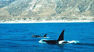
The Channel Islands are an eight-island archipelago located within the Southern California Bight in the Pacific Ocean, off the coast of California. The four Northern Channel Islands are part of the Transverse Ranges geologic province, and the four Southern Channel Islands are part of the Peninsular Ranges province. Five of the islands are within the Channel Islands National Park, and the waters surrounding these islands make up Channel Islands National Marine Sanctuary. The Nature Conservancy was instrumental in establishing the Channel Islands National Marine Sanctuary.

The National Ocean Service (NOS) is an office within the U.S. Department of Commerce, National Oceanic and Atmospheric Administration (NOAA). It is responsible for preserving and enhancing the nation's coastal resources and ecosystems along approximately 95,000 miles (153,000 km) of shoreline, that is bordering 3,500,000 square miles (9,100,000 km2) of coastal, Great Lakes and ocean waters. Its mission is to "provide science-based solutions through collaborative partnerships to address evolving economic, environmental, and social pressures on our oceans and coasts." The office works with partnered agencies to ensure that ocean and coastal areas are safe, healthy, and productive. It`s projects focus on working to ensure safe and efficient marine transportation, promoting the protection of coastal communities, conserving marine and coastal places. It employs 1,700 scientists, natural resource managers, and specialists in many different fields. The National Ocean Service was previously known as the National Ocean Survey until it was renamed in 1983.

<span class="mw-page-title-main">National Marine Sanctuary</span> Zone in US waters designated for special protection

A U.S. National Marine Sanctuary is a zone within United States waters where the marine environment enjoys special protection. The program was established in 1972 by the Marine Protection, Research, and Sanctuaries Act and is currently administered by the National Ocean Service through the National Marine Sanctuaries Act (NMSA).

<span class="mw-page-title-main">Greater Farallones National Marine Sanctuary</span> Marine protected area in California, USA

The Greater Farallones National Marine Sanctuary protects the wildlife, habitats, and cultural resources of one of the most diverse and bountiful marine environments in the world, an area of 3,295 square miles off the northern and central California coast. The waters within Greater Farallones National Marine Sanctuary are part of a nationally significant marine ecosystem, and support an abundance of life, including many threatened or endangered species.

<span class="mw-page-title-main">Marine protected area</span> Protected areas of seas, oceans, estuaries or large lakes

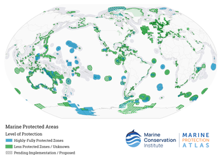
Marine protected areas (MPA) are protected areas of seas, oceans, estuaries or in the US, the Great Lakes. These marine areas can come in many forms ranging from wildlife refuges to research facilities. MPAs restrict human activity for a conservation purpose, typically to protect natural or cultural resources. Such marine resources are protected by local, state, territorial, native, regional, national, or international authorities and differ substantially among and between nations. This variation includes different limitations on development, fishing practices, fishing seasons and catch limits, moorings and bans on removing or disrupting marine life. In some situations, MPAs also provide revenue for countries, potentially equal to the income that they would have if they were to grant companies permissions to fish. The value of MPA to mobile species is unknown.

<span class="mw-page-title-main">Monterey Bay National Marine Sanctuary</span> Marine protected area in California, U.S.

The Monterey Bay National Marine Sanctuary (MBNMS) is a federally protected marine area offshore of California's Big Sur and central coast in the United States. It is the largest US national marine sanctuary and has a shoreline length of 276 miles (444 km) stretching from just north of the Golden Gate Bridge at San Francisco to Cambria in San Luis Obispo County. Supporting one of the world's most diverse marine ecosystems, it is home to numerous mammals, seabirds, fishes, invertebrates and plants in a remarkably productive coastal environment. The MBNMS was established in 1992 for the purpose of resource protection, research, education, and public use.

<span class="mw-page-title-main">Southern California Bight</span> Curved stretch of coastline in Southern California and northwestern Baja California

The Southern California Bight is a 692-kilometer-long stretch of curved coastline that runs along the west coast of the United States and Mexico, from Point Conception in California to Punta Colonet in Baja California, plus the area of the Pacific Ocean defined by that curve. This includes the Channel Islands of California and the Coronado Islands and Islas de Todo Santos of Baja California.

<span class="mw-page-title-main">Cordell Bank National Marine Sanctuary</span> Marine protected area off of California, USA

Cordell Bank National Marine Sanctuary is a marine sanctuary located off the coast of California. It protects an area of 1,286 sq mi (3,331 km2) of marine wildlife. The administrative center of the sanctuary is on an offshore granite outcrop 4.5 sq mi (12 km2) by 9.5 sq mi (25 km2), located on the continental shelf off of California. The outcrop is, at its closest, 6 mi (10 km) from the sanctuary itself.

<span class="mw-page-title-main">Papahānaumokuākea Marine National Monument</span> Protected region of ocean and islands

The Papahānaumokuākea Marine National Monument (PMNM) is a World Heritage listed U.S. National Monument encompassing 583,000 square miles (1,510,000 km2) of ocean waters, including ten islands and atolls of the Northwestern Hawaiian Islands. It was created in June 2006 with 140,000 square miles (360,000 km2) and expanded in August 2016 by moving its border to the limit of the exclusive economic zone, making it one of the world's largest protected areas. It is internationally known for its cultural and natural values as follows:

The area has deep cosmological and traditional significance for living Native Hawaiian culture, as an ancestral environment, as an embodiment of the Hawaiian concept of kinship between people and the natural world, and as the place where it is believed that life originates and to where the spirits return after death. On two of the islands, Nihoa and Mokumanamana, there are archaeological remains relating to pre-European settlement and use. Much of the monument is made up of pelagic and deepwater habitats, with notable features such as seamounts and submerged banks, extensive coral reefs and lagoons.

<span class="mw-page-title-main">Asilomar State Marine Reserve</span> Marine protected area in California

Asilomar State Marine Reserve (SMR) is one of four small marine protected areas (MPAs) located near the cities of Monterey and Pacific Grove, at the southern end of Monterey Bay on California’s central coast. The four MPAs together encompass 2.96 square miles (7.7 km2). The SMR protects all marine life within its boundaries. Fishing and take of all living marine resources is prohibited.

<span class="mw-page-title-main">Edward F. Ricketts State Marine Conservation Area</span> Marine protected area in California

Edward F. Ricketts State Marine Conservation Area is one of four small marine protected areas located near the cities of Monterey and Pacific Grove, at the southern end of Monterey Bay on California’s central coast. The four areas together encompass 2.96 square miles (7.7 km2). Within SMCAs fishing and take of all living marine resources is prohibited except the recreational take of finfish by hook-and-line and the commercial take of giant and bull kelp under certain conditions.

<span class="mw-page-title-main">Lovers Point State Marine Reserve</span> Marine protected area

Lovers Point State Marine Reserve (SMR) is one of four small marine protected areas located near the cities of Monterey and Pacific Grove, at the southern end of Monterey Bay on California’s central coast. The four MPAs together encompass 2.96 square miles (7.7 km2). The SMR protects all marine life within its boundaries. Fishing and take of all living marine resources is prohibited.

<span class="mw-page-title-main">Morro Bay State Marine Recreational Management Area and Morro Bay State Marine Reserve</span> Two marine protected areas in California

Morro Bay State Marine Recreational Management Area (SMRMA) and Morro Bay State Marine Reserve (SMR) are two marine protected areas that provide protection for Morro Bay Estuary on California's central coast. The two marine protected areas together encompass 3.31 square miles (8.6 km2). Within the SMRMA, fishing and take of any living marine resources is prohibited except that north of latitude 35° 19.70′ N the recreational take of finfish and aquaculture of oysters, pursuant to a valid state water bottom lease and permit, is permitted. And recreational hunting of waterfowl is allowed unless otherwise restricted by hunting regulations. The SMR protects all marine life within its boundaries. Fishing and take of any living marine resources is prohibited.

<span class="mw-page-title-main">Pacific Grove Marine Gardens State Marine Conservation Area</span> Marine protected area in California

Pacific Grove Marine Gardens State Marine Conservation Area is one of four small marine protected areas located near the cities of Monterey and Pacific Grove, at the southern end of Monterey Bay on California’s central coast. The four MPAs together encompass 2.96 square miles (7.7 km2). Within the SMCA fishing and take of all living marine resources is prohibited except the recreational take of finfish and the commercial take of giant and bull kelp by hand under certain conditions. According to the Frommer's guide, the Marine Gardens area is "renowned for ocean views, flowers, and tide-pool seaweed beds."

<span class="mw-page-title-main">Piedras Blancas State Marine Reserve and Marine Conservation Area</span> Marine protected areas in California

Piedras Blancas State Marine Reserve (SMR) and Piedras Blancas State Marine Conservation Area (SMCA) are two adjoining marine protected areas that lie offshore of San Luis Obispo County on California’s central coast. The combined area of these marine protected areas is 19.68 square miles (51.0 km2). The SMR protects all marine life within its boundaries. Fishing and take of all living marine resources is prohibited. Within the SMCA fishing and take of all living marine resources is prohibited except the commercial and recreational take of salmon and albacore.

<span class="mw-page-title-main">Point Sur State Marine Reserve and Marine Conservation Area</span> Protected area

Point Sur State Marine Reserve (SMR) and Point Sur State Marine Conservation Area (SMCA) are two adjoining marine protected areas that lie offshore of Point Sur, part of the Big Sur area on California's central coast. The combined area of these marine protected areas is 19.68 square miles (51.0 km2). The SMR protects all marine life within its boundaries. Fishing and taking of all living marine resources is prohibited in the SMR. Within the SMCA, fishing and taking of all living marine resources is prohibited except the commercial and recreational take of salmon and albacore.

Portuguese Ledge State Marine Conservation Area (SMCA) is an offshore marine protected area in Monterey Bay. Monterey Bay is on California’s central coast with the city of Monterey at its south end and the city of Santa Cruz at its north end. The SMCA covers 10.9 square miles (28 km2). Within the SMCA fishing and take of all living marine resources is prohibited except the commercial and recreational take of pelagic finfish.

<span class="mw-page-title-main">Soquel Canyon State Marine Conservation Area</span> Marine protected area in Monterey Bay

Soquel Canyon State Marine Conservation Area (SMCA) is an offshore marine protected area in Monterey Bay. Monterey Bay is on California’s central coast with the city of Monterey at its south end and the city of Santa Cruz at its north end. The SMCA covers 23.41 square miles (60.6 km2). Within the SMCA, fishing and taking of any living marine resources is prohibited except the commercial and recreational take of pelagic finfish.

<span class="mw-page-title-main">Marine policy of the Barack Obama administration</span>

The Marine Policy of the Barack Obama administration comprises several significant environmental policy decisions for the oceans made during his two terms in office from 2009 to 2017. By executive action, US President Barack Obama increased fourfold the amount of protected marine space in waters under United States control, setting a major precedent for global ocean conservation. Using the U.S. president's authority under the Antiquities Act of 1906, he expanded to 200 nautical miles the seaward limits of Papahānaumokuākea Marine National Monument in Hawaiʻi and the Pacific Remote Islands Marine National Monument around the U.S. island possessions in the Central Pacific. In the Atlantic, Obama created the Northeast Canyons and Seamounts Marine National Monument, the first marine monument in the U.S. exclusive economic zone (EEZ) in the Atlantic.

<span class="mw-page-title-main">Anacapa State Marine Reserve</span> Marine reserve in the United States

The Anacapa State Marine Reserve (SMR) is a protected marine reserve located off the coast of Southern California, encompassing the area of water immediately north of Anacapa Island. Established to safeguard the marine ecosystems and biodiversity of the region, the reserve is one of the thirteen Marine Protected Areas (MPAs) of the larger Channel Islands National Park network.

References

  1. "Channel Islands National Marine Sanctuary". channelislands.noaa.gov. Retrieved 2023-11-06.
  2. "NOAA Office of National Marine Sanctuaries". sanctuaries.noaa.gov. Retrieved 2023-11-06.
  3. "Learn | Channel Islands National Marine Sanctuary". channelislands.noaa.gov. Retrieved 2023-11-07.
  4. "Visitor Centers and Exhibits | Channel Islands National Marine Sanctuary". channelislands.noaa.gov. Retrieved 2023-11-07.
  5. "Outreach | Channel Islands National Marine Sanctuary". channelislands.noaa.gov. Retrieved 2023-11-07.
  6. "Students at Sea | Channel Islands National Marine Sanctuary". channelislands.noaa.gov. Retrieved 2023-11-07.
  7. "Teachers at Sea | Channel Islands National Marine Sanctuary". channelislands.noaa.gov. Retrieved 2023-11-07.
  8. Floating Forests Revealed, NASA Earth Observatory, January 6, 2015
  9. Hamilton, SL; Caselle, JE; Malone, DP; Carr, MH (2010). "Incorporating biogeography into evaluations of the Channel Islands marine reserve network". PNAS. 107 (43): 18272–18277. doi: 10.1073/pnas.0908091107 . PMC   2973008 . PMID   20176956.
  10. "Blue whale habitat and prey in the California Channel Islands". Deep Sea Research Part II: Topical Studies in Oceanography. 45.
  11. Administration, US Department of Commerce, National Oceanic and Atmospheric. "NOAA's Channel Islands National Marine Sanctuary". channelislands.noaa.gov. Retrieved 2016-11-05.{{cite web}}: CS1 maint: multiple names: authors list (link)
  12. "Things To Do | Channel Islands National Marine Sanctuary". channelislands.noaa.gov. Retrieved 2023-11-07.
  13. US Department of Commerce, National Oceanic and Atmospheric Administration. "NOAA's Channel Islands National Marine Sanctuary". channelislands.noaa.gov. Retrieved 2019-04-11.
  14. Rick, Torben C.; Erlandson, Jon M.; Vellanoweth, René L.; Braje, Todd J. (2005). "From Pleistocene Mariners to Complex Hunter-Gatherers: The Archaeology of the California Channel Islands". Journal of World Prehistory. 19 (3): 169–228. doi:10.1007/s10963-006-9004-x. S2CID   162492009.
  15. California, State of. "Threatened and Endangered Species - California Department of Fish and Wildlife". www.dfg.ca.gov. Retrieved 2016-11-05.
  16. "Island Fox - Channel Islands National Park (U.S. National Park Service)". www.nps.gov. Retrieved 2016-11-05.
  17. Keller, BD; Gleason, DF; McLeod, E; et al. (December 2009). "Climate Change, Coral Reef Ecosystems, and Management Options for Marine Protected Areas". Environmental Management. 44 (6): 1069–88. doi:10.1007/s00267-009-9346-0. PMC   2791481 . PMID   19636605.