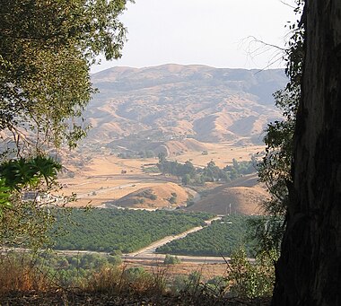
San Timoteo Canyon is a river valley canyon southeast of Redlands, in the far northwestern foothills of the San Jacinto Mountains in the Inland Empire region of Southern California.
San Timoteo Canyon is a river valley canyon southeast of Redlands, in the far northwestern foothills of the San Jacinto Mountains in the Inland Empire region of Southern California.
The canyon runs from its southern inflow mouth in Beaumont in Riverside County, in a northwest alignment, to its northern outflow mouth west of Redlands and east of Loma Linda in San Bernardino County. [1]
San Timoteo Creek formed the canyon, and flows northwest through it to its confluence with the Santa Ana River, being a tributary of it. The creek drains the Banning Valley west of the San Gorgonio Pass water divide, and the watersheds of the San Bernardino and San Jacinto Mountains that feed into it.
The canyon was part of the winter homeland of the Serrano people for thousands of years. There were hot springs in the area.
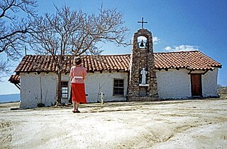
The San Bernardino de Sena Estancia was established in 1819 as a ranch outpost Mission San Gabriel Arcángel, for the grazing of cattle by the Mission Indians. The original buildings grew to include a chapel, tile kiln, lime kiln, and a grist mill.
The canyon was part of Rancho San Bernardino, the 1842 Mexican land grant by Alta California Governor Juan B. Alvarado to José del Carmen Lugo, José María Lugo, Vicente Lugo, and Diego Sepulveda. [2]
On the 27th day of May, 1851, Juan Antonio, the Californian Native American chief of the Mountain Cahuilla band, with a group of his tribesmen pursued and fought the Irving Gang of John "Red" Irving and his San Francisco and Sydney outlaws in San Timoteo Canyon. Irving's band of raiding thieves had robbed people and stolen property throughout the San Bernardino Valley, including on Rancho San Bernardino where Juan Antonio's Cahuilla village at Politana was located. Acting on the orders of the local Justice of the Peace, the Californio owner of the rancho and whose house the Irving Gang were robbing at the time, the Cahuilla attacked and pursued them into San Timoteo Canyon, where in a running fight they killed eleven of the twelve men in the gang after they refused to surrender. [3] There were decades of precedent for the Mountain Cahuilla who working on the local ranchos, tracking and hunting down bandits and other tribe's raiders was a service they were requested for in the San Bernardino region, during the 1822—1846 Mexican rule in Alta California. With this 1851 order, they were still authorized to carry out legally requested local law enforcement actions, now within the year old U.S. state. [3]
However some newly arrived American settlers to Southern California and the area resented the killing of "white men" by "indians" and mistook it to be the beginning of a Mission Indian uprising. A company of militia from the Presidio of San Diego was sent against the Cahuilla. [3] At the time, present day San Bernardino and Riverside Counties were within San Diego County, and served by troops based at the presidio. Juan Antonio's Cahuilla band fled Politana, going to their homelands in the San Jacinto Mountains. The American leader of the militia, Major General Joshua Bean, discovered the truth about the events and with difficulty restrained his troops from attacking the Cahuilla, preventing a battle and massacre. [3]
Closely following the outcome of the Irving Gang incident, in late 1851, Juan Antonio, his warriors and their families, moved eastward from Politana, toward the San Gorgonio Pass and settled in a valley which branched off to the north from San Timoteo Canyon, at a village named Saahatpa. [3]
In November 1851, the Garra Revolt occurred, a conflict of the Yuma War. The Cupeño leader Antonio Garra attempted to bring Juan Antonio and the Mountain Cahuilla band into the Serrano, Cahuilla and Cupeño Indians independence revolt. The Garra Revolt was put an end by Juan Antonio, a new ally of the Americans, who arrested Antonio Garra and handed him over to American authorities. [3]
One of San Timoteo Canyon's more famous residents was the teenaged Wyatt Earp, whose family lived in the canyon from 1864 to 1868.
The canyon was used in 1877 by the Southern Pacific Railroad for its new southern transcontinental route's tracks into/out of the Los Angeles Basin and Southern California, to/from the eastern U.S.
For a time in the mid-1950s it was considered as one of three possible alignments for the path of Interstate 10 in California, as part of the new Interstate Highway System program, though the central route through Redlands was selected. [4]
San Timoteo Canyon State Park is in development for public access and recreation facilities, and is not yet open. [5] [6] In 2001 a portion of the canyon, through the efforts of the Riverside Land Conservancy and others, was protected for a regional park, and then came under management of the California State Parks department. [7]
When the regional park opens, it will add some much-needed public open space for the fast-growing Inland Empire. The park's features will include: trails for hiking and horseback riding; the native flora and fauna of the canyon's varied habitats; and historical landmarks, including the San Timoteo Schoolhouse. [8]
The San Timoteo Canyon Schoolhouse, a museum and park operated by the Riverside County Parks department, was built in 1883, and added to the National Register of Historic Places on January 19, 2001. It was acquired by Riverside County Parks from the Beaumont Unified School District in 1993, but was not opened to the public until after 2007, when a five-year restoration was completed. [9]
Part of the wider San Timoteo Formation in the Badlands, fossils from the Pliocene and early Pleistocene have been excavated in San Timoteo Canyon since the early 1900's. [10] [11] [12]
In 2010, a construction crew found a deposit of Irvingtonian fossils dating back 1.4 million years ago in San Timoteo Canyon. The well-preserved natural cache contained nearly 1,500 bone fragments. They included those of: two species of sabretooth cats; ground sloths the size of a modern-day grizzly bear; two types of camels; and more than 1,200 bones from small rodents. Other finds include new species of deer, horse, and possibly llama. [13] [14] [15]
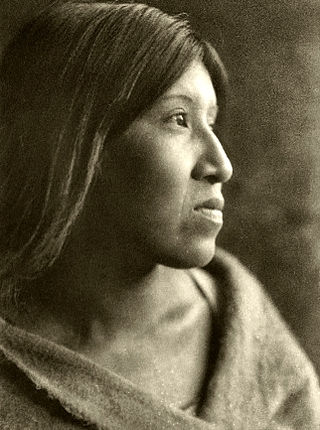
The Cahuilla, also known as ʔívil̃uqaletem or Ivilyuqaletem, are a Native American people of the various tribes of the Cahuilla Nation, living in the inland areas of southern California. Their original territory encompassed about 2,400 square miles (6,200 km2). The traditional Cahuilla territory was near the geographic center of Southern California. It was bounded to the north by the San Bernardino Mountains, to the south by Borrego Springs and the Chocolate Mountains, to the east by the Colorado Desert, and to the west by the San Jacinto Plain and the eastern slopes of the Palomar Mountains.

The San Bernardino de Sena Estancia was a ranch outpost of Mission San Gabriel Arcángel in what is now Redlands, California, United States. It was built to graze cattle, and for Indian reductions of the Serrano people and Cahuilla people into Mission Indians. Over time, it fell into disrepair, until the early 20th century, when a new, larger structure was built as a museum. The new structure shares the same architectural style, but is not otherwise similar to the original buildings.

The San Bernardino Valley is a valley in Southern California located at the south base of the Transverse Ranges. It is bordered on the north by the eastern San Gabriel Mountains and the San Bernardino Mountains; on the east by the San Jacinto Mountains; on the south by the Temescal Mountains and Santa Ana Mountains; and on the west by the Pomona Valley. Elevation varies from 590 feet (180 m) on valley floors near Chino to 1,380 feet (420 m) near San Bernardino and Redlands. The valley floor is home to over 80% of the more than 4 million people in the Inland Empire region.
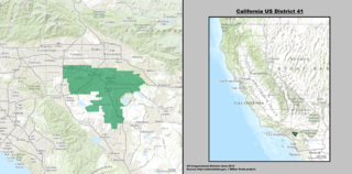
California's 41st congressional district is a congressional district in Riverside County, in the U.S. state of California. The district is currently represented by Republican Ken Calvert.
The Lugo family of California were prominent during the periods of Spanish and Mexican rule. They were among the early colonists who became known as Californios.
San Bernardino, California, was named in 1810.
The California Inland Empire Council (CIEC) of the Boy Scouts of America serves the Inland Empire of California. The service area comprises San Bernardino and Riverside Counties. The CIEC is headquartered in Redlands California where it has officwith ane and a Scout Shop.
Rancho San Bernardino was a 35,509-acre (143.70 km2) Mexican land grant in present-day San Bernardino County, California given in 1842 by Governor Juan B. Alvarado to José del Carmen Lugo, José María Lugo, Vicente Lugo, and Diego Sepulveda. The grant included a large part of the San Bernardino valley, and encompassed present-day San Bernardino, Fontana, Rialto, Redlands and Colton.
Warner Springs is set of springs and a small unincorporated community in northern San Diego County, California. Warner Springs is on the Pacific Crest Trail.
Rancho San Jacinto y San Gorgonio was a 4,440-acre (18.0 km2) Mexican land grant in present-day Riverside County, California given in 1843 by Governor Manuel Micheltorena to James (Santiago) Johnson. At the time of the US Patent, Rancho San Jacinto y San Gorgonio was a part of San Bernardino County. The County of Riverside was created by the California Legislature in 1893 by taking land from both San Bernardino and San Diego Counties. The grant encompassed San Timoteo Canyon.

Riverside County is a county located in the southern portion of the U.S. state of California. As of the 2020 census, the population was 2,418,185, making it the fourth-most populous county in California and the 10th-most populous in the United States. The name was derived from the city of Riverside, which is the county seat.
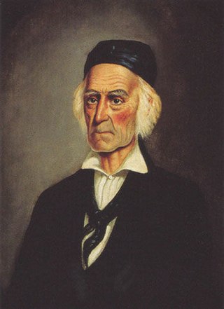
Juan Antonio, Cahuilla name: Cooswootna, Yampoochee,, was a major chief of the Mountain Band of the Cahuilla from the 1840s to 1863.

The Yuma War was the name given to a series of United States military operations conducted in southern California and what is today southwestern Arizona from 1850 to 1853. The Quechan were the primary opponent of the United States Army, though engagements were fought between the Americans and other native groups in the region.
Politana or Apolitana was the first Spanish settlement in the San Bernardino Valley of California. It was established as a mission chapel and supply station by the Mission San Gabriel in the a rancheria of the Guachama Indians that lived on the bluff that is now known as Bunker Hill, near Lytle Creek. Besides the Guachama, it was also at various times the home for colonists from New Mexico and Cahuilla people. Its most prominent landmark today is the St. Prophet Elias Greek Orthodox Church on Colton Avenue, just southwest of the Inland Center Mall, in San Bernardino, California.

Saahatpa was a former Cahuilla settlement in Riverside County. It was a settlement of Juan Antonio's Mountain Cahuilla from 1851 to 1863. It was located in a valley that branched to the northeast from San Timoteo Canyon. The site is marked by California Historical Landmark #749, and is located at the abandoned Brookside Rest Area on westbound Interstate 10 in modern-day Calimesa, California, nearly 3 miles northwest of the I-10/SR 60 junction.

San Timoteo Creek is a stream in Riverside and San Bernardino counties in southern California, United States. A tributary of the Santa Ana River, it flows through San Timoteo Canyon. San Timoteo Creek has a drainage basin of about 125 square miles (320 km2). The creek receives most of its water from headwater tributaries flowing from the San Bernardino Mountains near Cherry Valley, as well as Yucaipa Creek, which flows from Live Oak Canyon.

Reche Canyon is a canyon in the far northwestern foothills of the San Jacinto Mountains, northwest of The Badlands in the Inland Empire region of Southern California. The Tongva village of Homhoangna, from which the canyon's alternative names derives, was located here. The county line between San Bernardino County and Riverside County is at the approximate midway point of the canyon; the San Bernardino half to the north is mostly within the boundaries of Colton, with a small area in Loma Linda, while the southern half is unincorporated territory of Riverside County. Reche Canyon Elementary School is located in the northern part of the canyon.

Kaawchama, alternatively referred to as Wa’aachnga, was a significant Tongva village in the San Bernardino Valley located in what is now west Redlands, California. The village became referred to by the Spanish as the Guachama Rancheria in 1810 after a supply station was constructed at the village for Mission San Gabriel, which then became part of Rancho San Bernardino following the secularization of the missions in 1833.

The Mormon Trail Monument was designated a California Historic Landmark (No.577). The Monument is to remember the 500 Mormon pioneers came to the San Bernardino Valley in June 1851. The Monument is near Phelan, California in San Bernardino County, California. The Monument was built in 1937 and is on California State Route 138, 3.6 Miles West of Interstate 15. In 1857 about half the Mormons were told to return to Utah during the Mormon War, also call the Utah War. the Mormon War, or the Mormon Rebellion

Eden Hot Springs was a historic hot springs and resort in Riverside County, California, United States.