
Imperial County is a county located on the southeast border of the U.S. state of California. As of the 2020 census, the population was 179,702, making it the least populous county in Southern California. The county seat and largest city is El Centro. Imperial is the most recent California county to be established, as it was created in 1907 out of portions of San Diego County.

The Kumeyaay, also known as 'Iipai-Tiipai or by the historical Spanish name Diegueño, is a tribe of Indigenous peoples of the Americas who live at the northern border of Baja California in Mexico and the southern border of California in the United States. They are an indigenous people of California.

Boulevard is a census-designated place (CDP) in the Mountain Empire area of southeastern San Diego County, California. At that time, it had a population of 359 at the 2020 United States census, up from 315 2010 United States census. The area is rural high desert along the Mexican border near the eastern extent of San Diego County.

The Mexico–United States border is an international border separating Mexico and the United States, extending from the Pacific Ocean in the west to the Gulf of Mexico in the east. The border traverses a variety of terrains, ranging from urban areas to deserts. It is the most frequently crossed border in the world with approximately 350 million documented crossings annually. Illegal crossing of the border to enter the United States has caused the Mexico–United States border crisis. It is one of two international borders that the United States has, the other being the northern Canada–United States border; Mexico has two other borders: with Belize and with Guatemala.

Malpai Borderlands is a land area along the U.S.-Mexico border. It encompasses the southeast corner of Arizona and the southwest corner of New Mexico. It is sometimes defined as including areas in the Mexican states of Chihuahua and Sonora. The Malpai is part of the Madrean Region which includes the arid and semi-arid borderlands of the United States and Mexico from California to Texas.

Jacumba Hot Springs is an unincorporated community in the Mountain Empire area of southeastern San Diego County, California, United States. For statistical purposes, the United States Census Bureau defined Jacumba as a census-designated place (CDP) for the first time in the 2010 census, with a population of 561. At the 2020 census, the population decreased to 540. The census definition of the area may not precisely correspond to local understanding of the area with the same name. The ZIP code is 91934 and the town lies within area code 619. Its elevation is 2,829 feet (862 m) above mean sea level (AMSL). On February 26, 2013, the United States Board on Geographic Names approved a petition by a citizen committee to change the town's name from Jacumba to Jacumba Hot Springs.

The Campo Indian Reservation is home to the Campo Band of Diegueño Mission Indians, also known as the Campo Kumeyaay Nation, a federally recognized tribe of Kumeyaay people in the southern Laguna Mountains, in eastern San Diego County, California. The reservation was founded in 1893 and is 16,512 acres (66.82 km2).

The Coyote Mountains are a small mountain range in San Diego and Imperial County in Southern California. The Coyotes form a narrow ESE trending 2 mi (3.2 km) wide range with a length of about 12 mi (19 km). The southeast end turns and forms a 2 mi (3.2 km) north trending "hook". The highest point is Carrizo Mountain on the northeast end with an elevation of 2,408 feet (734 m). Mine Peak at the northwest end of the range has an elevation of 1,850 ft (560 m). Coyote Wash along Interstate 8 along the southeast margin of the range is 100 to 300 feet in elevation. Plaster City lies in the Yuha Desert about 5.5 mi (8.9 km) east of the east end of the range.

The Manzanita Band of Diegueño Mission Indians of the Manzanita Reservation is a federally recognized tribe of Kumeyaay Indians, who are sometimes known as part of the Mission Indians.

The Mountain Empire is a rural area in southeastern San Diego County, California. The Mountain Empire subregion consists of the backcountry communities in southeastern San Diego County. The area is also sometimes considered part of the East County region of San Diego County.
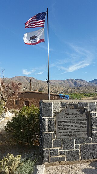
Vallecito, in San Diego County, California, is an oasis of cienegas and salt grass along Vallecito Creek and a former Kumeyaay settlement on the edge of the Colorado Desert in the Vallecito Valley. Its Spanish name is translated as "little valley". Vallecito was located at the apex of the gap in the Carrizo Badlands created by Carrizo Creek and its wash in its lower reach, to which Vallecito Creek is a tributary. The springs of Vallecito, like many in the vicinity, are a product of the faults that run along the base of the Peninsular Ranges to the west.
The Carrizo Creek and Carrizo Wash in California are a stream and an arroyo in San Diego County, California, and Imperial County, California.
San Pasqual, the Kumeyaay pueblo, in San Diego County, California, that was once located in the San Pasqual Valley and for which the valley is named.

Border Angels is a San Diego–based 501(c)(3) tax-exempt nonprofit charitable organization that is focused on migrant rights, immigration reform, and the prevention of immigrant deaths along the border. Border Angels, along with its more than 2000 volunteers serves San Diego County's immigrant population through various migrant outreach programs such as day laborer outreach and legal assistance, and provides life-saving assistance for migrants by placing bottled water in remote mountain and desert border regions of the San Diego and Imperial counties, California.

Carrizo Gorge is a valley in the Jacumba Mountains in San Diego County, California. Its mouth is at an elevation of 1,411 feet (430 m), where it widens out to become Carrizo Canyon, 1 mi (1.6 km) northeast of Palm Grove. Its head is located in the Jacumba Mountains, 1.5 mi (2.4 km) north of Round Mountain, at an elevation of 2,600 ft (790 m) at 32°39′38″N116°11′28″W.
Carrizo Valley is a valley between the Vallecito Mountains and Carrizo Badlands to the north and the Tierra Blanca Mountains, Jacumba Mountains and Coyote Mountains on the south, in San Diego County, California. Its mouth is at an elevation or 623 feet / 190 meters. Its source is at an elevation of 1,315 feet at 32°58′07″N116°18′37″W at the mouth of the narrow Carrizo Canyon where Vallecito Creek passes between the Tierra Blanca Mountains and Vallecito Mountains.
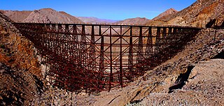
Goat Canyon Trestle is a wooden trestle in San Diego County, California. At a length of 597–750 feet (182–229 m), it is the world's largest all-wood trestle. Goat Canyon Trestle was built in 1933 as part of the San Diego and Arizona Eastern Railway, after one of the many tunnels through the Carrizo Gorge collapsed. The railway had been called the "impossible railroad" upon its 1919 completion. It ran through Baja California and eastern San Diego County before ending in Imperial Valley. The trestle was made of wood, rather than metal, due to temperature fluctuations in the Carrizo Gorge. By 2008, most rail traffic stopped using the trestle.
Goat Canyon is a valley in San Diego County, California, United States, located within the Carrizo Gorge in the Jacumba Mountains. The rock forming the canyon is crystalline basement. One feature of the canyon is a dry waterfall. The canyon is bridged by a wooden railroad trestle, the Goat Canyon Trestle, which is the world's largest curved all-wood trestle. The canyon is accessible by trail by traveling west from Mortero Palms.

Hostile Terrain 94 (HT94) is a participatory art project created and organized by the Undocumented Migration Project (UMP). The exhibition is composed of approximately 3,400 handwritten toe tags that represent migrants who have died trying to cross the Sonoran Desert of Arizona between the mid-1990s and 2021. The tags are geolocated on a large wall map of the Arizona/Mexico border, showing the exact locations where human remains were found. This DIY installation is taking place at over 120 institutions––in the U.S. and abroad––with the intention to raise awareness about the humanitarian crisis at America's southern border and to engage with communities around the world in conversations about migration.
Missing in Brooks County is a 2020 feature-length documentary, directed and filmed by Lisa Molomot and Jeff Bemiss. Its subject is the passage of illegal migrants through Brooks County, Texas, and specifically how thousands die of dehydration and exposure hiking some 35 miles (56 km) across open fields in 100 °F (38 °C) heat, to avoid the Border Patrol internal checkpoint near Falfurrias, Texas. The ground is sandy and taxing to walk in, and lack of landmarks makes it easy for migrants to get lost and go in circles. Brooks County leads the nation in migrant deaths; most bodies are never found, and most of those found are never identified. The county sheriff calls the county "the biggest cemetery in the United States". News stories have called it "migrants' Death Valley."