
San Bernardino County, officially the County of San Bernardino and sometimes abbreviated as S.B. County, is a county located in the southern portion of the U.S. state of California, and is located within the Inland Empire area. As of the 2020 U.S. Census, the population was 2,181,654, making it the fifth-most populous county in California and the 14th-most populous in the United States. The county seat is San Bernardino.

Mohave County occupies the northwestern corner of the U.S. state of Arizona. As of the 2020 census, its population was 213,267. The county seat is Kingman, and the largest city is Lake Havasu City. It is the fifth largest county in the United States.

Mojave National Preserve is a United States National Preserve located in the Mojave Desert of San Bernardino County, California, US, between Interstate 15 and Interstate 40. The preserve was established October 31, 1994, with the enactment of the California Desert Protection Act by the United States Congress, which also established Joshua Tree National Park and Death Valley National Park as National Parks. Previously, some lands contained within the Preserve were the East Mojave National Scenic Area, under the jurisdiction of the Bureau of Land Management. At 1,542,776 acres (6,243 km2), within the contiguous United States it is the third largest unit of the National Park System and the first largest National Preserve. The preserve was created within the Pacific West Region of the National Park Service and remains within that jurisdiction today.
Lake Mead National Recreation Area is a U.S. national recreation area in Southeastern Nevada and Northwestern Arizona. Operated by the National Park Service, Lake Mead NRA follows the Colorado River corridor from the westernmost boundary of Grand Canyon National Park to just north of the cities of Laughlin, Nevada and Bullhead City, Arizona. It includes all of the eponymous Lake Mead as well as the smaller Lake Mohave – reservoirs on the river created by Hoover Dam and Davis Dam, respectively – and the surrounding desert terrain and wilderness.

The Dead Mountains are a mountain range in the southeastern Mojave Desert, in San Bernardino County, California. The range borders the tri-state intersection of Nevada, Arizona and California, and the Mohave Valley, with the Fort Mojave Indian Reservation bordering the range foothills on the east and northeast, in the three states.

The El Paso Mountains Wilderness was created in 1994 and now has a total of 23,780 acres (96.2 km2). All of the wilderness is in the northern Mojave Desert in eastern Kern County, California and is managed by the Bureau of Land Management. It is located south of Ridgecrest, California.

The Hualapai Mountains are a mountain range located in Mohave County, east of Kingman, Arizona. Rising up to 8,417 feet at its highest peak, the higher elevations of the Hualapai Mountains support Madrean Sky Island habitats, and are host to a plethora of unique flora and fauna in a wide range of microclimates, high above the surrounding Mojave Desert.
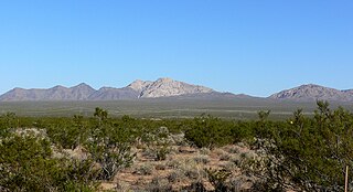
The Piute Mountains are a mountain range located in the Eastern Mojave Desert and within Mojave Trails National Monument, in San Bernardino County, California.

The Bigelow Cholla Garden Wilderness is in the eastern Mojave Desert and within Mojave Trails National Monument, located in San Bernardino County, California.
The Newberry Mountains in Nevada are located east of Cal-Nev-Ari and the United States Coast Guard LORAN station in the southern part of the state. The range is Nevada's southernmost named mountain range, and lies to the northwest of the town of Laughlin and west of Lake Mohave. The Newberry Mountains connect with the Eldorado Mountains and The Highland Mountains. The highest point in the range is Spirit Mountain at 5,642 feet (1,720 m).

Old Woman Mountains Wilderness is a wilderness area in the Old Woman Mountains of the eastern Mojave Desert. It is located south of Essex in San Bernardino County, California.

The Darwin Falls Wilderness is a protected area in the northern Mojave Desert adjacent to Death Valley National Park. The 8,189-acre (3,314 ha) wilderness area was created by the California Desert Protection Act of 1994 and is managed by the Bureau of Land Management as part of the National Wilderness Preservation System.

The Santa Rosa Wilderness is a 72,259-acre (292.42 km2) wilderness area in Southern California, in the Santa Rosa Mountains of Riverside and San Diego counties, California. It is in the Colorado Desert section of the Sonoran Desert, above the Coachella Valley and Lower Colorado River Valley regions in a Peninsular Range, between La Quinta to the north and Anza Borrego Desert State Park to the south. The United States Congress established the wilderness in 1984 with the passage of the California Wilderness Act, managed by both the US Forest Service and the Bureau of Land Management. In 2009, the Omnibus Public Land Management Act was signed into law which added more than 2,000 acres (8.1 km2). Most of the Santa Rosa Wilderness is within the Santa Rosa and San Jacinto Mountains National Monument.

Spirit Mountain Wilderness Area is a 33,518-acre (13,564 ha) wilderness area located in the Newberry Mountains in Clark County, Nevada, 10 miles (16 km) northwest of Laughlin. Spirit Mountain lies within the area. It is managed by the Bureau of Land Management and the National Park Service.

Riverside County is a county located in the southern portion of the U.S. state of California. As of the 2020 census, the population was 2,418,185, making it the fourth-most populous county in California and the 10th-most populous in the United States. The name was derived from the city of Riverside, which is the county seat.

The Clipper Mountain Wilderness is a wilderness area in the Clipper Mountains of the eastern Mojave Desert and within Mojave Trails National Monument, located in northeastern San Bernardino County, California. It is under the jurisdiction of the Bureau of Land Management.

Saddle Peak Hills Wilderness is the smallest designated wilderness area created by the California Desert Protection Act of 1994.

Ireteba Peaks Wilderness is a 32,745 acre wilderness area spanning the area of the southern part of Eldorado Mountains to the northern parts of Lake Mohave. It is located 45 miles (72 km) south of Las Vegas and was designated as a wilderness area in 2002. Iretaba Peaks Wilderness is managed by the National Park Service and the Bureau of Land Management. The western (BLM) portion of the wilderness is part of Avi Kwa Ame National Monument, designated in 2023.
Grass Valley Wilderness is a wilderness area in San Bernardino County, California, near Ridgecrest. It mainly consists of low-lying hills and flat desert covered by vegetation typical of the Mohave Desert, like creosote bush, desert scrub, and isolated stands of Joshua trees. Fauna consists of the desert tortoise and the Mohave ground squirrel. Naval Air Weapons Station China Lake borders the area to the east and a non-wilderness road bisects the area.

Golden Valley Wilderness is a wilderness area located in San Bernardino County, California, near Ridgecrest. It covers 37,786 acres of the Mojave Desert, straddling both the Almond Mountains to the southeast and the Lava Mountains to the northwest in the Golden Valley. Steep canyons of sedimentary rocks line the valley walls, rising as much as 5,000 feet on Dome Mountain. In terms of wildlife, creosote bush scrub dominate the vegetation, while Joshua trees and wildflowers grow intermittently. The area also provides habitat for raptors, Mojave ground squirrels, and desert tortoises.
