Colusa County is a county located in the U.S. state of California. As of the 2020 census, the population was 21,839. The county seat is Colusa. It is in the northern Sacramento Valley, northwest of the state capital, Sacramento.
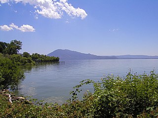
Lake County is a county located in the north central portion of the U.S. state of California. As of the 2020 census, the population was 68,163. The county seat is Lakeport. The county takes its name from Clear Lake, the dominant geographic feature in the county and the largest non-extinct natural lake wholly within California.

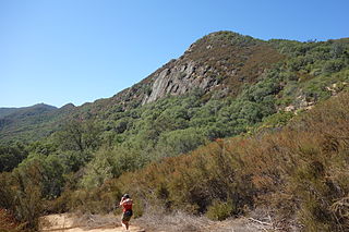
The Santa Monica Mountains is a coastal mountain range in Southern California, next to the Pacific Ocean. It is part of the Transverse Ranges. The Santa Monica Mountains National Recreation Area encompasses this mountain range. Because of its proximity to densely populated regions, it is one of the most visited natural areas in California.

Lake Berryessa is the largest lake in Napa County, California. This reservoir in the Vaca Mountains was formed following the construction of the Monticello Dam on Putah Creek in the 1950s. Since the early 1960s, this reservoir has provided water and hydroelectricity to the North Bay region of the San Francisco Bay Area.

The Patwin are a band of Wintun people in Northern California. The Patwin comprise the southern branch of the Wintun group, native inhabitants of California since approximately 500.

The Mayacamas Mountains are located in northwestern California in the United States. The mountain range is part of the Northern Inner Coast Ranges, of the California Coast Ranges System.

The Fish Creek Mountains Wilderness is located about 25 miles west of Brawley, California, and southeast of the Vallecito Mountains in the United States. The wilderness is located in the Fish Creek Mountains region in the northern part of the Carrizo Impact Area, which is closed to the public.
The community of San Antonio Valley, also called San Antonio or San Antone, is located along the Diablo Range in eastern Santa Clara County, California. The locale is bordered by Alameda County to the north and Stanislaus County to the east. The sparsely populated area is located at the junction of San Antonio Valley Road, Mines Road, and Del Puerto Canyon Road. The area includes the San Antonio Valley Ecological Reserve, a 3,282-acre nature preserve created by a Nature Conservancy purchase of land from local rancher, Keith Hurner, and known for its herd of tule elk.

Cache Creek is an 87-mile-long (140 km) stream in Lake, Colusa and Yolo counties, California.

The Sweetwater River is a 55-mile (89 km) long stream in San Diego County, California.

Putah Creek is a major stream in Northern California, a tributary of the Yolo Bypass, and ultimately, the Sacramento River. The 85-mile-long (137 km) creek has its headwaters in the Mayacamas Mountains, a part of the Coast Range, and flows east through two dams. First, Monticello Dam forms Lake Berryessa, below which Putah Creek forms the border of Yolo and Solano Counties, and then flows to the Putah Diversion Dam and Lake Solano. After several drought years in the late 1980s, the majority of Putah Creek went dry, prompting a landmark lawsuit that resulted in the signing of the Putah Creek Accord in 2000. The Accord established releases from the dams to maintain stream flows in Putah Creek, with natural flow regimes which spike in winter/spring and ebb in summer/fall. The restoration of natural flow regimes has resulted in a doubling of riparian bird species and a return of spawning native steelhead trout and Chinook salmon, as well as protecting the livelihood of farmers on the lower watershed.

The Vaca Mountains are a mountain range in Napa and Solano Counties, California that is one of the California Coast Ranges. They represent the easternmost of the Inner Coast Ranges in north−central California, and divide the Suisun Valley on their west, from the Sacramento Valley on their east.

Adams is an unincorporated community in Lake County, California. It was formerly Adams Springs, a summer resort developed around a small group of mineral water springs.
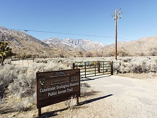
Canebrake Ecological Reserve is a 6,700-acre (27 km2) nature reserve in the South Fork Valley of Kern County, 20 miles (32 km) east of Lake Isabella, California. It is located in the Southern Sierra Nevada region.

The Blue Ridge Berryessa Natural Area is a conservation area forming a contiguous corridor of 800,000 acres (3,200 km2) in northern California. It is a mix of public and private lands overseen by the Blue Ridge Berryessa Natural Area Conservation Partnership. The Partnership was founded in 1997 as a forum for land managers to discuss land use activities, primarily Homestake Mining Company surplus acreage at McLaughlin mine. The meetings evolved into a regional conservation focus and effort.

The Middle Fork Eel River is a major tributary of the Eel River of northwestern California in the United States. It drains a rugged and sparsely populated region of the Yolla Bolly Mountains, part of the California Coast Range, in Trinity and Mendocino Counties. Its watershed comprises roughly 745 square miles (1,930 km2) of land, or 20% of the entire Eel River basin. The river provides groundwater recharge and is used for recreation and for industrial, agricultural and municipal water supply by residents.
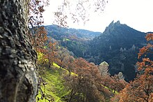
Stebbins Cold Canyon Reserve is a unit of the University of California Natural Reserve System and is administered by the University of California, Davis. It is within the Blue Ridge Berryessa Natural Area, in the Northern Inner California Coast Ranges.

Rivers and creeks in Lake County, California are listed below by river basin and alphabetically. Unless otherwise stated, the information is taken from the Geographic Names Information System maintained by the United States Geological Survey. Coordinates, elevations and lengths from this source are approximate.
The Gardner Swamp Wildlife Area is a 1,180 acres (480 ha) tract of protected land located in Door County, Wisconsin, managed by the Wisconsin Department of Natural Resources. Land to be used for the Wildlife Area was first acquired in 1958, and the master plan for the Wildlife Area was completed in 1980.
The Big Beaver Creek Wildlife Area is a 572-acre (231 ha) tract of protected land located in Dunn County, Wisconsin, managed by the Wisconsin Department of Natural Resources (WDNR). Land to be used for the wildlife area was first acquired in 1959 to provide access to the Big Beaver Creek and Little Beaver Creek, along with the associated wetlands complex. The other major goal was to open up the area to state-sponsored timber harvesting, specifically that of tamarack.