San Gabriel Mountains National Monument

Last updated
San Gabriel Mountains National Monument
Throop Peak Mount Hawkins 033.jpg
Usa edcp relief location map.png
Red pog.svg
Location Los Angeles County, California, United States
Coordinates 34°15′0″N117°50′20″W / 34.25000°N 117.83889°W
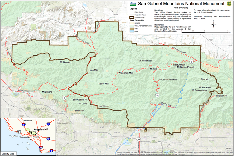
 / 34.25000; -117.83889
Area346,177 acres (140,093 ha)
EstablishedOctober 10, 2014 (2014-10-10)
Governing body U.S. Forest Service
Website San Gabriel Mountains National Monument

The San Gabriel Mountains National Monument is a United States National Monument managed by the U.S. Forest Service, which encompasses parts of the Angeles National Forest and the San Bernardino National Forest in California. On October 10, 2014, President Barack Obama used his authority under the Antiquities Act to create the new monument, protecting 346,177 acres of public lands in the San Gabriel Mountains of the Transverse Ranges. [1] The effort to protect the San Gabriel Mountains began more than a century earlier, in 1891 with another U.S. President, Benjamin Harrison, the 23rd president, using a congressional act, to designate and delineate the first federal protection in the United States of forested lands, using the same mountain range name, as the San Gabriel Timberland Reserve. Two earlier California conservationists, Abbot Kinney and John Muir, influenced President Benjamin Harrison.

Contents

Geography

Telegraph Peak Telegraph Peak.jpg
Telegraph Peak

The monument covers the central and northern regions of the San Gabriel Mountains, extending west to east from Upper Sand Canyon at Little Tujunga Canyon Road to Telegraph Peak. It contains the Sheep Mountain Wilderness, the San Gabriel Wilderness, and Pleasant View Ridge Wilderness. Most of the major peaks of the San Gabriels are within the limits of the monument, including Mount San Antonio, Mount Baden-Powell, and Throop Peak. The Silver Moccasin Trail lies within the monument. The monument only covers a limited portion of the range's western extent, and much of the southern portion of the range has been excluded from the monument. It does not contain the Cucamonga Peak region. [2]

Monument history

The movement to further preserve the San Gabriel Mountains began in 2003 when then Congresswoman Hilda Solis initiated an environmental feasibility report to see if it was possible to increase protection by National Monument designation. [3]

Establishment of the National Monument

President Obama signs proclamation declaring the San Gabriel Mountains as a national monument Obama declares San Gabriel Mountains a National Monument.jpg
President Obama signs proclamation declaring the San Gabriel Mountains as a national monument

The National Monument was established on October 10, 2014, by proclamation of President Barack Obama under the Antiquities Act. More than 15 million people live within 90 minutes of the San Gabriel Mountains, which provides 70 percent of the open space for Angeleños and 30 percent of their drinking water. Polling indicated that 80 percent of Los Angeles County voters supported the proposed protection of the San Gabriel Mountains and rivers. [4]

The creation of the monument was in response to decades of input and support from the local community demanding greater environmental protections for the heavily touristed region. There have been longstanding concerns about pollution and vandalism in the region's subalpine forests and watersheds. Public health and Latino groups also advocated for protecting the public lands in the San Gabriel Mountains as an opportunity to protect access to open space and outdoor recreation as a way to counter the shortage of parks and open space in Los Angeles County which they claim has contributed to high childhood obesity rates. [5]

The Obama administration cited the presence of endangered species, important cultural resources, and the threat of unreliable funding for management and encroaching development as the proximal reasons for the establishment of the monument. In addition, all existing rights-of-way continue to be honored and existing recreational activities — such as hiking, camping, fishing and cycling — will be unaffected. [6]

Local officials, including Los Angeles Mayor Eric Garcetti, cheered the news along with Hispanic, recreation, and conservation groups. [7] Its establishment faced limited opposition from local residents. To alleviate concerns, the extent of the monument does not cover most of the southern slopes of the San Gabriel Mountains, and excludes towns in the region. [6]

Proposed Expansion

In May of 2023, Representative Judy Chu and Senator Alex Padilla introduced a package of bills that would expand the monument by over 100,000 acres and additionally designate 31,000 acres as protected wilderness. [8] [9] In June of 2023, Chu and Padilla sent a letter to President Joe Biden asking him to expand the monument by proclamation under the Antiquities Act. [10]

See also

Related Research Articles

<span class="mw-page-title-main">National forest (United States)</span> Classification of federal lands in the United States

In the United States, national forest is a classification of protected and managed federal lands that are largely forest and woodland areas. They are owned collectively by the American people through the federal government and managed by the United States Forest Service, a division of the United States Department of Agriculture. The U.S. Forest Service is also a forestry research organization which provides financial assistance to state and local forestry industry. There are 154 national forests in the United States.

<span class="mw-page-title-main">National monument (United States)</span> Monuments assigned protected status by Presidents of the US

In the United States, a national monument is a protected area that can be created from any land owned or controlled by the federal government by proclamation of the President of the United States or an act of Congress. National monuments protect a wide variety of natural and historic resources, including sites of geologic, marine, archaeological, and cultural importance. In contrast, national parks in the U.S. must be created by Congressional legislation. Some national monuments were first created by presidential action and later designated as national parks by congressional approval.

<span class="mw-page-title-main">Pinnacles National Park</span> National park in California, United States of America

Pinnacles National Park is an American national park protecting a mountainous area located east of the Salinas Valley in Central California, about five miles (8.0 km) east of Soledad and 80 miles (130 km) southeast of San Jose. The park's namesakes are the eroded leftovers of the western half of an extinct volcano that has moved 200 miles (320 km) from its original location on the San Andreas Fault, embedded in a portion of the California Pacific Coast Ranges. Pinnacles is managed by the National Park Service and the majority of the park is protected as wilderness.

<span class="mw-page-title-main">San Gabriel Mountains</span> Mountain range of the Transverse Ranges in California, United States

The San Gabriel Mountains are a mountain range located in northern Los Angeles County and western San Bernardino County, California, United States. The mountain range is part of the Transverse Ranges and lies between the Los Angeles Basin and the Mojave Desert, with Interstate 5 to the west and Interstate 15 to the east. The range lies in, and is surrounded by, the Angeles and San Bernardino National Forests, with the San Andreas Fault as its northern border.

<span class="mw-page-title-main">Angeles National Forest</span> National forest in California, United States

The Angeles National Forest (ANF) of the U.S. Forest Service is located in the San Gabriel Mountains and Sierra Pelona Mountains, primarily within Los Angeles County in southern California. The ANF manages a majority of the San Gabriel Mountains National Monument.

<span class="mw-page-title-main">Los Padres National Forest</span> National forest in California, United States

Los Padres National Forest is a United States national forest in southern and central California. Administered by the United States Forest Service, Los Padres includes most of the mountainous land along the California coast from Ventura to Monterey, extending inland. Elevations range from sea level to 8,847 feet (2,697 m).

<span class="mw-page-title-main">San Gorgonio Wilderness</span> Protected wilderness area in California, United States

The San Gorgonio Wilderness is located in the eastern San Bernardino Mountains, in San Bernardino County and into northern Riverside County, Southern California.

<span class="mw-page-title-main">Castle Mountains (California)</span>

The Castle Mountains are located in the Eastern Mojave Desert, in northeastern San Bernardino County, California and Clark County, Nevada. The range lies south and east of the New York Mountains, southwest of Searchlight and west of Cal-Nev-Ari, Nevada.

<span class="mw-page-title-main">Santa Rosa and San Jacinto Mountains National Monument</span> Protected area in California

The Santa Rosa and San Jacinto Mountains National Monument is a National Monument in southern California. It includes portions of the Santa Rosa and San Jacinto mountain ranges, the northernmost ones of the Peninsular Ranges system. The national monument covers portions of Riverside County, west of the Coachella Valley, approximately 100 miles (160 km) southeast of downtown Los Angeles.

<span class="mw-page-title-main">California Coastal National Monument</span> All islets, reefs and rock outcroppings

The California Coastal National Monument is located along the entire coastline of the U.S. state of California. This monument ensures the protection of all islets, reefs and rock outcroppings along the coast of California within 12 nautical miles (22 km) of shore along the entire 840-mile (1,350 km) long coastline. Conservative estimates are for at least 20,000 such outcroppings. The monument was created by Bill Clinton via Presidential proclamation on January 11, 2000, with the authority in section two of the Antiquities Act of 1906. As of 2014, the monument has expanded to 2,272 acres (919 ha). The U.S. Bureau of Land Management, an agency of the U.S. Department of the Interior that manages the monument, has developed gateways in cooperation with other agencies along the California coast to introduce the monument to the public. These include the Trinidad, Point Arena, Fort Bragg-Mendocino, Pigeon Point Lighthouse, Piedras Blancas State Marine Reserve and Marine Conservation Area, and the Palos Verdes Peninsula. Although being the most-viewed national monument in California, people are usually unaware that the entire coastline is a national monument.

<span class="mw-page-title-main">The Wilderness Society (United States)</span> American non-profit organization

The Wilderness Society is an American non-profit land conservation organization that is dedicated to protecting natural areas and federal public lands in the United States. They advocate for the designation of federal wilderness areas and other protective designations, such as for national monuments. They support balanced uses of public lands, and advocate for federal politicians to enact various land conservation and balanced land use proposals. The Wilderness Society also engages in a number of ancillary activities, including education and outreach, and hosts one of the most valuable collections of Ansel Adams photographs at their headquarters in Washington, D.C.

<span class="mw-page-title-main">Omnibus Public Land Management Act of 2009</span>

The Omnibus Public Land Management Act of 2009 is a land management law passed in the 111th United States Congress and signed into law by President Barack Obama on March 30, 2009. The bill designates millions of acres in the US as protected and establishes a National Landscape Conservation System. It includes funding for programs, studies and other activities by the Department of the Interior and the Department of Agriculture, and in some cases bars further geothermal leasing, oil and gas leasing, and new mining patents on certain stretches of protected land.

<span class="mw-page-title-main">Cucamonga Wilderness</span> Protected wilderness area in California, United States

The Cucamonga Wilderness is a federally designated wilderness area located in the eastern San Gabriel Mountains, in San Bernardino County, Southern California.

<span class="mw-page-title-main">Browns Canyon National Monument</span> Protected habitat in Chaffee County, Colorado

Browns Canyon National Monument is a 21,586 acres (87 km2) national monument in Chaffee County, Colorado, that was designated as such by President Barack Obama under the Antiquities Act on February 19, 2015. The site will be centered along the Arkansas River between Buena Vista and Salida. Browns Canyon is the most popular destination for whitewater rafting in the country, and is also known for its fishing and hiking. The monument will provide habitat protection for bighorn sheep, peregrine falcons, elk, and golden eagles.

<span class="mw-page-title-main">Basin and Range National Monument</span> National monument in southeastern Nevada, United States

Basin and Range National Monument is a national monument of the United States spanning approximately 704,000 acres of remote, undeveloped mountains and valleys in Lincoln and Nye counties in southeastern Nevada. It is described as "one of the emptiest spaces in a state famous for its emptiness."

<span class="mw-page-title-main">Berryessa Snow Mountain National Monument</span> Land preserve in the Coastal Ranges of California

Berryessa Snow Mountain National Monument is a national monument of the United States comprising 330,780 acres (133,860 ha) of the California Coast Ranges in Napa, Yolo, Solano, Lake, Colusa, Glenn and Mendocino counties in northern California. Cache Creek Wilderness is located within the monument.

<span class="mw-page-title-main">Castle Mountains National Monument</span> Protected area in Mojave Desert, California

Castle Mountains National Monument is a U.S. National Monument located in the eastern Mojave Desert and northeastern San Bernardino County, in the state of California.

<span class="mw-page-title-main">Sand to Snow National Monument</span> National monument in California, United States

Sand to Snow National Monument is a U.S. National Monument located in San Bernardino County and northern Riverside County, Southern California.

<span class="mw-page-title-main">Bears Ears National Monument</span> Protected area in Utah

Bears Ears National Monument is a United States national monument located in San Juan County in southeastern Utah, established by President Barack Obama by presidential proclamation on December 28, 2016. The monument protects 1,351,849 acres of public land surrounding the Bears Ears—a pair of buttes—and the Indian Creek corridor rock climbing area. The Native American names for the buttes have the same meaning in each of the languages represented in the region. The names are listed in the presidential proclamation as "Hoon’Naqvut, Shash Jáa [sic], Kwiyaghatʉ Nükavachi/Kwiyagatu Nukavachi, Ansh An Lashokdiwe"—all four mean "Bears Ears".

References

  1. "President Obama Designates San Gabriel Mountains National Monument". whitehouse.gov . 10 October 2014. Retrieved 10 October 2014 via National Archives.
  2. USFS Map(broken link)
  3. Modern Hiker (27 Mar 2015). "What's Next for the San Gabriel Mountains National Monument?". (broken link)
  4. San Gabriel Mountains Forever (18 August 2014). "Los Angeles County Voters Ask President to Protect San Gabriels". Archived from the original on 16 December 2014.
  5. Jose Calderon (12 September 2014). "San Gabriel Mountains Should be Protected as a National Monument".
  6. 1 2 Louis Sahagun (10 October 2014). "Obama officially designates San Gabriel Mountains a national monument".
  7. Laura Barron-Lopez (10 October 2014). "Obama names new national monument".
  8. "Pasadena Congresswoman Joins U.S. Senator to Introduce Bill Expanding San Gabriel Mountains National Monument – Pasadena Now". www.pasadenanow.com. Retrieved 2023-06-26.
  9. "Padilla Introduces Bill to Protect 1 Million Acres of California Public Lands". Senator Alex Padilla. Retrieved 2023-06-26.
  10. https://www.latimes.com/people/louis-sahagun (2023-06-26). "California Congress members call for expansion of San Gabriel Mountains National Monument". Los Angeles Times. Retrieved 2023-06-26.{{cite web}}: External link in |last= (help)