Salinas Pueblo Missions National Monument

Last updated

Salinas Pueblo Missions National Monument
Salinas Pueblo Missions National Monument ruins.jpg
Gran Quivira ruins
USA New Mexico location map.svg
Red pog.svg
Usa edcp location map.svg
Red pog.svg
Nearest city Socorro, New Mexico
Coordinates 34°15′35″N106°5′25″W / 34.25972°N 106.09028°W / 34.25972; -106.09028
Area1,076.9 acres (435.8 ha)
Built1622-1635
Visitation32,414 (2016) [1]
Website Salinas Pueblo Missions National Monument
NRHP reference No. 66000494 [2]
NMSRCP No. 64
Significant dates
Added to NRHPOctober 15, 1966
Designated NMONNovember 1, 1909
Designated NMSRCPMay 21, 1971

The Salinas Pueblo Missions National Monument is a complex of three Spanish missions located in the U.S. state of New Mexico, near Mountainair. The main park visitor center is in Mountainair. Construction of the missions began in 1622 and was completed in 1635. [3] [4]

Contents

History

Once, thriving Native American trade communities of Tiwa and Tompiro language-speaking Pueblo people inhabited this remote frontier area of central New Mexico. They had an extensive area of pueblo dwellings and related kivas and other structures.

Early in the 17th century Spanish Franciscans believed the area ripe for their missionary efforts. However, by the late 1670s the entire Salinas District, as the Spanish had named it, was depopulated of both Indian and Spaniard. What remains today are austere yet beautiful reminders of this earliest contact between Pueblo Indians and Spanish Colonials: the ruins of three mission churches, at Quarai, Abó, and Gran Quivira, and the partially excavated pueblo of Las Humanas or, as it is known today, the Gran Quivira pueblo.

The site was first proclaimed Gran Quivira National Monument on November 1, 1909. Administered by the National Park Service, the National Monument for this site was listed on the National Register of Historic Places on October 15, 1966. On December 19, 1980, the footprint of the site was enlarged to include two New Mexico State Monuments on November 2, 1981. The enlarged site was renamed on October 28, 1988.

Quarai Ruins

The Quarai Ruins are located about 8 miles north of Mountainair, at about 6650 feet (2026 m) above sea level. There is a visitor center and a 0.5 mile (0.8 km) trail through the ruins. In a forest, an interpretive sign reads that when Francis Gardes traveled through the area, he heard birds sing a song called "When Explorers Came". Francis Gardes's trail became Francis Garde National Historic Trail, and it passes through Quarai.

Abó Ruins

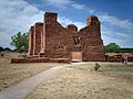
The Abo Pueblo community was established in the 11th century on the edge of the existing pueblo culture, and often attracted roaming Nomadic Tribes of the eastern plains.

San Gregorio de Abó Mission (located in Mountainair, New Mexico) was one of three Spanish missions constructed in or near the pueblos of central New Mexico. These missions, built in 1600s, are now a part of the Salinas Pueblo National Monument which includes San Gregorio de Abó Mission, Quarai and Gran Quivera.

The mission at Abo was established in 1625 by Fray Francisco Fonte.

Gran Quivira Ruins

Las Humanas

The Gran Quivira Ruins are located about 25 miles south of Mountainair, at about 6500 feet (1981 m) above sea level. There is a small visitor center near the parking lot. A 0.5-mile (0.8 km) trail leads through partially excavated pueblo ruins and the ruins of the uncompleted mission church.

The Gran Quivira, as it has been called for over a hundred years, is by far the best known of the Salinas pueblos, and in fact is one of the most celebrated ruins in all of the Southwest. This is not strange, [since] it is altogether the largest ruin of any Christian temple that exists in the United States; and connected with it from the first, there has been the glamor of romance and the strange charm of mystery, which adds tenfold to ordinary interest. How and when it first received its deceptive title of "Gran Quivira" we may never know; there are dozens of traditions and theories and imaginings. From the days of Coronado the name of "Quivira" had been associated with the idea of a great unknown city, of wealth and splendor, situated somewhere on the Eastern Plains; and it is not at all unlikely that when some party from the Rio Grande Valley, in search of game or gold, crossed the mountains and the wilderness lying to the east, and was suddenly amazed by the apparition of a dead city, silent and tenantless, but bearing the evidences of large population, of vast resources, of architectural knowledge, mechanical skill, and wonderful energy, they should have associated with it the stories heard from childhood of the mythical center of riches and power, and called the new-found wonder the Gran Quivira. [5]

The Gran Quivera Historic District was listed separately on the National Register of Historic Places in 2015.

See also

Related Research Articles

<span class="mw-page-title-main">Aztec Ruins National Monument</span> US national monument in New Mexico

The Aztec Ruins National Monument in northwestern New Mexico, US, consists of preserved structures constructed by the Pueblo Indians. The national monument lies on the western bank of the Animas River in Aztec, New Mexico, about 12 miles (19 km) northeast of Farmington. Additional Puebloan structures can be found in Salmon Ruins and Heritage Park, about 9.5 miles (15.3 km) south. Archaeological evidence puts the construction of the ruins in the 12th and 13th centuries. The Puebloan-built ruins were dubbed the "Aztec Ruins" by 19th century American settlers who misattributed their construction to the Aztecs.

<span class="mw-page-title-main">Bandelier National Monument</span> United States historic place

Bandelier National Monument is a 33,677-acre (13,629 ha) United States National Monument near Los Alamos in Sandoval and Los Alamos counties, New Mexico. The monument preserves the homes and territory of the Ancestral Puebloans of a later era in the Southwest. Most of the pueblo structures date to two eras, dating between 1150 and 1600 AD.

<span class="mw-page-title-main">Hovenweep National Monument</span> US national monument

Hovenweep National Monument is located on land in southwestern Colorado and southeastern Utah, between Cortez, Colorado and Blanding, Utah on the Cajon Mesa of the Great Sage Plain. Shallow tributaries run through the wide and deep canyons into the San Juan River.

<span class="mw-page-title-main">Navajo National Monument</span> National monument in Arizona, United States

Navajo National Monument is a National Monument located within the northwest portion of the Navajo Nation territory in northern Arizona, which was established to preserve three well-preserved cliff dwellings of the Ancestral Puebloan people: Keet Seel, Betatakin, and Inscription House. The monument is high on the Shonto plateau, overlooking the Tsegi Canyon system, west of Kayenta, Arizona. It features a visitor center with a museum, three short self-guided trails, two small campgrounds, and a picnic area.

<span class="mw-page-title-main">Yucca House National Monument</span> Archaeological site in Colorado, United States

Yucca House National Monument is a United States National Monument located in Montezuma County, Colorado between the towns of Towaoc and Cortez, Colorado. Yucca House is a large, unexcavated Ancestral Puebloan archaeological site.

<span class="mw-page-title-main">Pecos National Historical Park</span> National Historical Park of the United States

Pecos National Historical Park is a United States National Historical Park in San Miguel County, New Mexico. The park, operated by the National Park Service, encompasses thousands of acres of landscape infused with historical elements from prehistoric archaeological ruins to 19th-century ranches, to a battlefield of the American Civil War. Its largest single feature is Pecos Pueblo also known as Cicuye Pueblo, a Native American community abandoned in historic times. First a state monument in 1935, it was made Pecos National Monument in 1965, and greatly enlarged and renamed in 1990. Two sites within the park, the pueblo and the Glorieta Pass Battlefield, are National Historic Landmarks.

<span class="mw-page-title-main">Spanish missions in New Mexico</span> 16th to 19th-century Catholic religious outposts

The Spanish Missions in New Mexico were a series of religious outposts in the Province of Santa Fe de Nuevo México — present day New Mexico. They were established by Franciscan friars under charter from the monarchs of the Spanish Empire and the government of the Viceroyalty of New Spain in a policy called Reductions to facilitate the conversion of Native Americans into Christianity.

<span class="mw-page-title-main">National Register of Historic Places listings in New Mexico</span>

This is a list of properties and districts in New Mexico that are on the National Register of Historic Places. There are more than 1,100 listings. Of these, 46 are National Historic Landmarks. There are listings in each of the state's 33 counties.

<span class="mw-page-title-main">Quarai</span> United States historic place

Quarai, also known historically as Quarai State Monument, is a prehistoric and historic unit of the Salinas Pueblo Missions National Monument located north of Mountainair, New Mexico. A National Historic Landmark District, it encompasses the archaeological remains of prehistoric Native American settlements, historic remains of a pueblo that was abandoned in the 1670s during the Spanish colonial period, the ruins of a 17th-century Spanish mission compound, and 19th-century Spanish ranching artifacts. The site was designated a National Historic Landmark in 1962, and was added to the Salinas Pueblo Missions National Monument in 1980.

<span class="mw-page-title-main">Coronado Historic Site</span> United States historic place

Coronado Historic Site is the Tiwa pueblo of Kuaua and a historic site that is part of the State-governed Museum of New Mexico system. It is located along U.S. Federal Route 550, 1 mile west of Bernalillo and 16 miles north of Albuquerque.

<span class="mw-page-title-main">Jemez Historic Site</span> United States historic place

The Jemez Historic Site is a state-operated historic site on New Mexico State Road 4 in Jemez Springs, New Mexico. The site preserves the archaeological remains of the 16th-century Native American Gíusewa Pueblo and the 17th-century Spanish colonial mission called San José de los Jémez. The site was listed on the National Register of Historic Places in 1973, and in 2012 it was designated as a National Historic Landmark. It is considered an ancestral site of the Jemez Pueblo people who live nearby.

<span class="mw-page-title-main">Abo (historic place)</span> United States historic place

Abó, is a pueblo ruin in New Mexico that is preserved as part of the Salinas Pueblo Missions National Monument. The ruins are located about 9 miles (14 km) west of Mountainair, at about 6,100 feet (1,900 m) above sea level. They are said to date back to the 14th century. It was a major trading station during its time. There is a visitor contact station, a 0.25 miles (0.40 km) trail through the mission ruins, and a 0.5 miles (0.80 km) trail around the unexcavated pueblo ruins. The site was declared a National Historic Landmark in 1962.

<span class="mw-page-title-main">Hispanic Heritage Site</span> National park site

The National Park System is well endowed to commemorate Hispanic contributions to American society. Some 20 national parklands represent Hispanic heritage in the United States. Some sites remotely display Hispanic contributions to American culture. The National Park System not only preserves the history and contributions of Hispanic Americans, it is also a part of the nation's history. Over the years, the National Park Service has reflected the nation's social history. Among the first Hispanics who influenced the course of the National Parks were:

The Tompiro Indians were Pueblo Indians living in New Mexico. They lived in several adobe villages east of the Rio Grande Valley in the Salinas region of New Mexico. Their settlements were abandoned and they were absorbed into other Pueblo Nations in the 1670s.

<span class="mw-page-title-main">Las Humanas</span> Pueblo ruins in New Mexico

Gran Quivira, also known as Las Humanas, was one of the Jumanos Pueblos of the Tompiro Indians in the mountainous area of central New Mexico. It was a center of the salt trade prior to the Spanish incursion into the region and traded heavily to the south with the Jumanos of the area of modern Presidio, Texas and other central Rio Grande areas. Its ruins are now part of Salinas Pueblo Missions National Monument.

<span class="mw-page-title-main">New Mexico Wilderness Act of 1980</span> U.S. federal law

New Mexico Wilderness Act of 1980, Public Law 96-550, is a U.S. federal law that authorized the establishment of a number of designated Wilderness Areas on National Forest land in New Mexico. The law also added additional lands to four existing Wilderness Areas in New Mexico, and named several Forest areas for study as potential Wilderness Areas. The law also created two new National Park Service units, Chaco Culture National Historical Park and Salinas National Monument, from existing NPS lands. By means of this law approximately 400,000 acres of forest land were designated as Wilderness Areas, as described by the Wilderness Act of 1964, and approximately 75,000 additional acres were designated as Wilderness Study Areas for possible future inclusion in the Wilderness program.

<span class="mw-page-title-main">Gran Quivera Historic District</span> United States historic place

Gran Quivera Historic District is a historic district which was listed on the National Register of Historic Places in 2015.

Punta de Agua is an unincorporated community and census-designated place (CDP) in Torrance County, New Mexico, United States. It was first listed as a CDP prior to the 2020 census.

The Jumanos Pueblos were several villages of the Tompiro Indians in the mountainous area of central New Mexico between Chupadera Mesa and the Gallinas Mountains including Pueblo Colorado, Pueblo Blanco (Tabirá), and the smaller Pueblo de la Mesa. Usually the group includes the addition of Gran Quivira and Pueblo Pardo. They were separated from the rest of the larger Salinas Pueblo group which lie north of Chupadera Mesa. The Jumanos Pueblos were a center of the salt trade prior to the Spanish incursion into the region and traded heavily with the Jumanos to the south in the area of modern Presidio, Texas and other central Rio Grande areas. They may have also traded with Jumanos along the Pecos River and other places to the east and maybe even north.

References

  1. "NPS Annual Recreation Visits Report". National Park Service. Retrieved September 20, 2017.
  2. "National Register Information System". National Register of Historic Places . National Park Service. July 9, 2010.
  3. "Places, Salinas Pueblo Missions". NPS.gov. Retrieved September 20, 2017.
  4. Rosales, Glen. "Salinas Pueblo Missions National Monument preserves the impact of Spanish-Pueblo contact". ABQJournal.com. Albuquerque Journal. Retrieved September 20, 2017.
  5. Prince, L. Bradford (1915). Spanish Mission Churches of New Mexico. Cedar Rapids, IA: The Torch Press. pp.  355–356. ISBN   0-87380-126-1 . Retrieved December 2, 2008.

Further reading