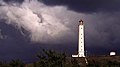
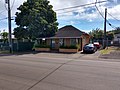
This is a list of properties and historic districts in Hawaii listed on the National Register of Historic Places. More than 370 listings appear on all but one of Hawaii's main islands (Niihau being the exception) and the Northwestern Islands, and in all of its five counties. Included are houses, schools, archeological sites, ships, shipwrecks and various other types of listings. These properties and districts are listed by island, beginning at the northwestern end of the chain.
This National Park Service list is complete through NPS recent listings posted December 20, 2024. [1]
The following are approximate tallies of current listings by island and county. These counts are based on entries in the National Register Information Database as of April 24, 2008 [2] and new weekly listings posted since then on the National Register of Historic Places web site, all of which list properties simply by county; [3] they are here divided by island for the sake of easier navigation. There are frequent additions to the listings and occasional delistings, and the counts here are approximate and not official. New entries are added to the official Register on a weekly basis. [4] Also, the counts in this table exclude boundary increase and decrease listings which modify the area covered by an existing property or district and which carry a separate National Register reference number. The number of NRHP listings on each island are documented by tables in each of the individual island lists, and the number of listings in each county is determined by adding the totals of the islands in that county. Kalawao and Maui counties are the sole exception: Kalawao County is a peninsula on Molokai, which is otherwise a part of Maui County.
Island | # of Sites | |
---|---|---|
1 | Northwestern Hawaiian Islands | 3 |
2 | Niihau | 0 |
3 | Kauai | 40 |
4 | Oahu | 169 |
5 | Molokai | 27 |
6 | Lanai | 2 |
7 | Maui | 39 |
8 | Kahoolawe | 1 |
9 | Hawaii | 94 |
TOTAL | 375 | |
County | # of Sites | |
---|---|---|
1 | Hawaii | 94 |
2 | Honolulu | 172 |
3 | Kalawao | 2 |
4 | Kauai | 40 |
5 | Maui | 67 |
TOTAL | 375 |
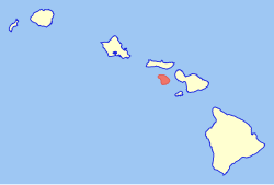
Many small islands, all uninhabited, lie northwest of Kauai. They are included in Honolulu County, [a] despite the vast distance between them and Oahu. [5]
[6] | Name on the Register | Image | Date listed [7] | Location | Community | Description |
---|---|---|---|---|---|---|
1 | Necker Island Archeological District | ![]() | June 13, 1988 (#88000641) | Address Restricted 23°34′00″N164°42′00″W / 23.5667°N 164.7°W | Necker Island | Part or all of the island |
2 | Nihoa Island Archeological District | ![]() | June 13, 1988 (#88000640) | Address Restricted 23°03′41″N161°55′32″W / 23.06141°N 161.92543°W | Nihoa Island | Part or all of the island |
3 | TWO BROTHERS (New England whaling ship) Shipwreck | ![]() | August 7, 2017 (#100001416) | Address Restricted | French Frigate Shoals |
Kauai is the northernmost of the major islands of Hawaii, and except for Niihau, the westernmost. Together with Niihau, it forms Kauai County.
[6] | Name on the Register | Image | Date listed [7] | Location | Community | Description |
---|---|---|---|---|---|---|
1 | Bishop National Bank of Hawaii | November 29, 1978 (#78001026) | Hawaii Route 50 21°57′17″N159°39′59″W / 21.954614°N 159.66648°W | Waimea | Now First Hawaiian Bank, 4525 Panako Rd., Waimea | |
2 | Camp Sloggett | ![]() | August 5, 1993 (#93000773) | Southwest of Hawaii Route 550 22°07′26″N159°39′02″W / 22.123791°N 159.650499°W | Koke'e State Park | Now YWCA Camp |
3 | Civilian Conservation Corps Camp in Koke'e State Park | December 20, 1996 (#96001504) | Hawaii Route 550 at Kokeʻe State Park Headquarters 22°07′51″N159°39′33″W / 22.130842°N 159.659174°W | Koke'e State Park | ||
4 | Coco Palms Resort | ![]() | February 16, 2021 (#100006139) | 4-241 Kuhio Highway 22°02′57″N159°20′09″W / 22.0493°N 159.3359°W | Kapaa | |
5 | Cook Landing Site | October 15, 1966 (#66000298) | 2 miles (3.2 km) southwest of Hawaii Route 50 21°57′11″N159°39′57″W / 21.9531°N 159.6657°W | Waimea | ||
6 | Charles Gay House | November 1, 1984 (#84000203) | Gay Rd. 21°58′00″N159°39′39″W / 21.9666°N 159.6607°W | Waimea | ||
7 | Grove Farm | June 25, 1974 (#74000722) | On Hawaii Route 58, about 1-mile (1.6 km) southeast of Lihue 21°57′59″N159°22′06″W / 21.9663°N 159.3682°W | Lihue | Homestead of plantation owner George N. Wilcox, built 1864, converted to museum in 1978 | |
8 | Grove Farm Company Locomotives | January 19, 1979 (#79000761) | Off Hawaii Route 50 21°58′06″N159°23′50″W / 21.9683°N 159.3972°W | Puhi | ||
9 | Gulick-Rowell House | April 15, 1978 (#78001027) | Missionary Row (now Huakai Rd.) 21°57′41″N159°40′19″W / 21.9614°N 159.6719°W | Waimea | Across from Waimea Canyon Middle School, on way to Kauai Veterans Memorial Hospital, first built 1829 by Rev. Peter Johnson Gulick, completed by Rev. George Rowell in 1846 | |
10 | Haena Archeological Complex | November 16, 1984 (#84000257) | Beyond Ha'ena State Park at end of Hawaii Route 560 between high cliffs and rocky shore of Kēʻē Bay 22°13′10″N159°35′05″W / 22.2195°N 159.5848°W | Hanalei | Sites: (1) house of high chief Lohiʻau (lover of Hi'iaka); (2) Ke-ahu-a-Laka hālau hula platform; (3) Ka-ulu-a-paʻoa heiau platform [8] | |
11 | Hanalei Elementary School | March 14, 1990 (#90000344) | 5-5161 Kuhio Hwy. 22°12′10″N159°29′46″W / 22.2027°N 159.4960°W | Hanalei | Built 1926 | |
12 | Hanalei Pier | ![]() | September 13, 1979 (#79000757) | Hanalei Bay 22°12′45″N159°29′52″W / 22.2126°N 159.4979°W | Hanalei | |
13 | Hanapepe Town Lot No. 18 | ![]() | October 13, 1993 (#93001033) | Hanapepe Rd. west of its junction with Ko Rd. 21°54′41″N159°35′10″W / 21.9114°N 159.5861°W | Hanapepe | Former pool hall |
14 | Haraguchi Rice Mill | ![]() | August 25, 1983 (#83000252) | Ohiki Rd. 22°12′35″N159°28′36″W / 22.2097°N 159.4767°W | Hanalei | In Hanalei Valley, one of four former rice mills |
15 | Kaua'i Belt Road-North Shore section | February 11, 2004 (#03001048) | Hawaii Route 560 22°12′43″N159°31′40″W / 22.2119°N 159.5278°W | Princeville | All or part of Hawaii Route 560 | |
16 | Kikiaola | November 16, 1984 (#84000270) | Menehune Rd., Waimea 21°58′31″N159°39′35″W / 21.9753°N 159.6597°W | Waimea | A historic ditch purportedly built by the Menehune | |
17 | Kilauea Plantation Head Bookkeeper's House | August 5, 1993 (#93000774) | 2421 Kolo Rd. 22°12′18″N159°24′36″W / 22.2050°N 159.4100°W | Kilauea | ||
18 | Kilauea Plantation Head Luna's House | August 5, 1993 (#93000775) | 2457 Kolo Rd. 22°12′21″N159°24′38″W / 22.2058°N 159.4106°W | Kilauea | ||
19 | Kilauea Plantation Manager's House | August 5, 1993 (#93000777) | 4591 Kuawa Rd. 22°12′08″N159°24′35″W / 22.2023°N 159.4096°W | Kilauea | ||
20 | Kilauea Point Light Station | ![]() | October 18, 1979 (#79000759) | Kilauea Point National Wildlife Refuge 22°13′54″N159°24′07″W / 22.2316°N 159.4020°W | Kilauea | A lighthouse located on a narrow peninsula on Kauai's northern coast |
21 | Kilauea School | August 18, 1983 (#83000254) | 2440 Kolo Rd. 22°12′22″N159°24′34″W / 22.2062°N 159.4094°W | Kilauea | Est. 1882 | |
22 | Kong Lung Store | August 5, 1993 (#93000776) | 2484 Keneke Street, on Kilauea Lighthouse Rd., half-mile north of Hawaii Route 56 22°12′44″N159°24′25″W / 22.212318°N 159.407009°W | Kilauea | Originally built to be the Kilauea Plantation store | |
23 | Kukui Heiau | May 18, 1987 (#86002746) | At Alakukui Point on north shore of Wailua Bay (accessible via public right-of-way between the Kauai Sands and Lae Nani Condominium) 22°03′04″N159°19′46″W / 22.051235°N 159.329433°W | Wailua | On state land donated by neighboring condo developers; now landscaped, but retains facing walls and offers good view of Wailua Bay [9] | |
24 | Lihue Civic Center Historic District | December 17, 1981 (#81000204) | Off Hawaii Route 50 21°58′30″N159°22′02″W / 21.975126°N 159.367199°W | Lihue | ||
25 | Lihue Hongwanji Mission | March 21, 1978 (#78001025) | North of Lihue at Hawaii Route 56 21°59′25″N159°21′56″W / 21.990303°N 159.365633°W | Lihue | At 3-3556-A Kuhio Highway, a branch of Honpa Hongwanji Mission of Hawaii | |
26 | Menehune Fishpond | ![]() | March 14, 1973 (#73000677) | On the Hulēʻia River south of Lihue (viewable from lookout on south side of Puhi Road) 21°56′55″N159°22′20″W / 21.948738°N 159.372314°W | Lihue | Also called Alekoko or Niamalu Pond, bounded by wall 900 yards long at large bend in Hulēʻia River [10] |
27 | Na Pali Coast Archeological District | November 16, 1984 (#84000266) | Address Restricted | Hanalei | ||
28 | Old Sugar Mill of Koloa | October 15, 1966 (#66000296) | Maluhia and Koloa Rds. 21°54′17″N159°27′57″W / 21.90463°N 159.465816°W | Koloa | The mill for Hawaii's first commercially successful sugarcane plantation | |
29 | Opaekaa Road Bridge | March 28, 1983 (#83000253) | ʻŌpaekaʻa Rd. 22°03′32″N159°22′41″W / 22.058895°N 159.378138°W | Kapaʻa | First built 1890 | |
30 | Pu'u'opae Bridge | May 25, 2005 (#05000536) | Puʻuʻōpae Bridge between Kalama and Kipapa Rds. 22°04′06″N159°22′23″W / 22.0684°N 159.373096°W | Kapaʻa | One-lane, concrete-encased steel bridge on Puʻuʻōpae Rd. at Kipapa Rd. | |
31 | Russian Fort | ![]() | October 15, 1966 (#66000299) | On Hawaii Route 50, 200 yards southwest of the bridge over the Waimea River 21°57′07″N159°39′52″W / 21.951852°N 159.664383°W | Waimea | |
32 | Sakuichi and Chieko Matsumoto Residence | March 21, 2024 (#100010092) | 2257 Kuai Road 21°52′30″N159°27′06″W / 21.87496°N 159.4517°W | Poipu | ||
32 | Seto Building | September 4, 1979 (#79000758) | 4-1435 Kuhio Highway 22°04′39″N159°19′01″W / 22.077478°N 159.31698°W | Kapaʻa | ||
33 | Sueoka Market | August 16, 2019 (#100004288) | 5392 Koloa Rd. 21°54′15″N159°27′55″W / 21.9042°N 159.4654°W | Koloa | ||
34 | US Post Office-Lihue | November 28, 1989 (#89002011) | 4441 Rice St. 21°58′29″N159°22′08″W / 21.974788°N 159.369004°W | Lihue | ZIP code 96766 | |
35 | Wailua Complex of Heiaus | October 15, 1966 (#66000297) | At the mouth of the Wailua River in the Lihue District, on the eastern coast of Kauai 22°02′37″N159°20′09″W / 22.04372°N 159.335959°W | Wailua | Many ruins of old heiau, ancient Hawaiian temples | |
36 | Waioli Mission District | October 3, 1973 (#73000676) | Off Hawaii Route 560 22°12′04″N159°30′04″W / 22.201111°N 159.501111°W | Hanalei | Established 1834; Mission Hall, built in 1841, is oldest extant church building on the island; was Congregational, now United Church of Christ | |
37 | Albert Spencer Wilcox Beach House | July 30, 1993 (#93000725) | 4943 Weke Rd. 22°12′35″N159°29′44″W / 22.209651°N 159.495607°W | Hanalei | ||
38 | Albert Spencer Wilcox Building | May 31, 1979 (#79000760) | 4428 Rice St. 21°58′30″N159°22′06″W / 21.975026°N 159.368257°W | Lihue | Designed by Hart Wood in 1922, opened as public library in 1924, converted to Kauaʻi Museum in 1970 | |
39 | Yamase Building | April 12, 1996 (#96000398) | 4493 Moana Rd. 21°57′20″N159°40′09″W / 21.955532°N 159.669033°W | Waimea |
Oahu is the only major island in Honolulu County. The location of the city of Honolulu, Oahu is the most populous island in the state.
Molokai is the northernmost of the islands of Maui County. Unlike every other island in the state, it is divided between two counties: Kalawao County consists of the island's northern peninsula.
[6] | Name on the Register | Image | Date listed [7] | Location | Community | Description |
---|---|---|---|---|---|---|
1 | Kalaupapa National Historical Park | ![]() | January 7, 1976 (#76002145) | Coextensive with the county 21°10′40″N156°57′36″W / 21.177778°N 156.96°W | Kalaupapa | Park preserving sites of two isolation settlements for Hansen's disease sufferers. |
2 | U.S. Coast Guard Molokai Light | ![]() | March 25, 1982 (#82001724) | North of Kalaupapa 21°12′44″N156°58′21″W / 21.212222°N 156.9725°W | Kalaupapa | A lighthouse. |
Lanai is the smallest of the populated islands of Maui County, lying between the islands of Maui and Molokai.
[6] | Name on the Register | Image | Date listed [7] | Location | Community | Description |
---|---|---|---|---|---|---|
1 | Kaunolu Village Site | October 15, 1966 (#66000303) | On southwest coast 20°44′05″N156°57′52″W / 20.734722°N 156.964444°W | Lanai City | Former fishing village, abandoned in the 1880s, that is the largest surviving ruins of a prehistoric Hawaiian village. | |
2 | Pu'upehe Platform (50La19) | October 6, 1986 (#86002745) | Between Mānele Bay and Hulopoʻe Bay 20°44′02″N156°53′24″W / 20.733889°N 156.89°W | Lanai City | Also known as Sweetheart Rock |
Maui is the largest and the easternmost island of Maui County.
[6] | Name on the Register | Image | Date listed [7] | Location | Community | Description |
---|---|---|---|---|---|---|
1 | Fred C. Baldwin Memorial Home | December 1, 2011 (#11000437) | 1813 Baldwin Ave. 20°53′12″N156°20′43″W / 20.886667°N 156.345278°W | Makawao | 
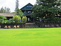
Built in 1910 by Emily Alexander Baldwin and Henry Perrine Baldwin to provide housing for the elderly. Named for their son Fred Baldwin (1881–1905). [11] Originally designed by H.L. Kerr; restored in 2011 by Xorin Balbes to operate as a lodging and educational facility named Lumeria Maui. [12] | |
2 | Henry Perrine Baldwin High School | June 30, 2000 (#00000667) | Junction of Lower Main St. and Kaahumanu Ave. 20°53′45″N156°29′38″W / 20.895833°N 156.493889°W | Wailuku | ||
3 | Bank of Hawaii—Haiku Branch | ![]() | December 4, 2000 (#00001284) | 771 Haiku Rd. 20°54′53″N156°19′22″W / 20.914722°N 156.322778°W | Haʻikū | Built 1931 to serve as bank and post office for bustling Haʻikū; restored in 1998; now used as a commercial property. [13] |
4 | Chee Kung Tong Society Building | ![]() | November 15, 1982 (#82000171) | 2151 Vineyard St. 20°53′36″N156°30′29″W / 20.893333°N 156.508056°W | Wailuku | Part of the Chinese Tong Houses of Maui Island TR #82000173. Collapsed in 1996; only gate and foundation remain. |
5 | Crater Historic District | ![]() | November 1, 1974 (#74000289) | Address Restricted | Kahului | |
6 | Frank and Theresa Gomes House | June 15, 2001 (#01000616) | 32 Pakani Place 20°50′58″N156°19′03″W / 20.849444°N 156.3175°W | Makawao | ||
7 | Haiku Mill | February 6, 1986 (#86000189) | Haiku Rd. 20°55′49″N156°19′58″W / 20.930278°N 156.332778°W | Haʻikū | ||
8 | Hale Paʻi | May 13, 1976 (#76000662) | Lahainaluna High School 20°53′40″N156°39′45″W / 20.894444°N 156.6625°W | Lahaina | ||
9 | Halekii-Pihana Heiau | November 25, 1985 (#85002972) | Hea Pl. off Kuhio Pl. from Waiehu Beach Rd. 20°54′30″N156°29′42″W / 20.908333°N 156.495°W | Wailuku | ||
10 | Hana Belt Road | ![]() | June 15, 2001 (#01000615) | Hana Highway (Hawaii Route 360) and Pi'ilani Highway (Hawaii Route 31) 20°53′52″N156°13′20″W / 20.897778°N 156.222222°W | Makawao | |
11 | Hana District Police Station and Courthouse | August 27, 1991 (#91001086) | Uakea Rd. 20°45′44″N155°59′21″W / 20.762222°N 155.989167°W | Hana | ||
12 | Hardy House | November 8, 1984 (#84002640) | 808 Makawao Ave. 20°51′06″N156°19′25″W / 20.851667°N 156.323611°W | Makawao | 
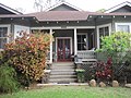
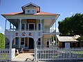
Built in 1897 for Makawao School principal Frederick Hardy (d. 1920) & wife Lillian, who sold the house & 20-acre (81,000 m2) lot in 1920. Ernest and Alene Rezents bought the house in 1961 and restored what is now locally known as the Rezents House. [14] | |
13 | Holy Ghost Catholic Church | August 18, 1983 (#83000255) | 4300 Lower Kula Rd. 20°46′04″N156°20′22″W / 20.767778°N 156.339444°W | Kula | ||
14 | Honokalani Village | November 25, 1985 (#85003333) | Address Restricted | Hana | ||
15 | Iao Theater | February 9, 1995 (#94001622) | 68 N. Market St. 20°53′37″N156°30′17″W / 20.893611°N 156.504722°W | Wailuku | ||
16 | Ka'ahumanu Avenue-Naniloa Drive Overpass | November 19, 2008 (#08001065) | Naniloa Dr. at Kaahumanu Ave. 20°53′19″N156°29′46″W / 20.88871°N 156.49602°W | Wailuku | ||
17 | Ka'ahumanu Church | May 12, 1975 (#75000622) | S. High St. 20°53′49″N156°30′01″W / 20.896944°N 156.500278°W | Wailuku | Est. 1876 | |
18 | Kahului Railroad Administration Building | ![]() | May 17, 2016 (#16000274) | 101 E. Kaahumanu Ave. 20°53′34″N156°27′52″W / 20.892678°N 156.464474°W | Kahului | |
19 | Kalepolepo Fishpond | ![]() | December 30, 1996 (#96001503) | S. Kihei Rd., south of its junction with Hawaii Route 31 in Kalepolepo County Park 20°46′00″N156°27′45″W / 20.766667°N 156.4625°W | Kihei | |
20 | William K. Kaluakini House | July 3, 2013 (#13000458) | 450 Front St. 20°52′00″N156°40′26″W / 20.866688°N 156.673843°W | Lahaina | ||
21 | Kaupo School | June 30, 2000 (#00000662) | Government Rd. 20°38′13″N156°07′21″W / 20.636866°N 156.122592°W | Kaupo | ||
22 | Keanae School | June 30, 2000 (#00000665) | Hana Highway 20°51′21″N156°08′29″W / 20.855833°N 156.141389°W | Keanae | ||
23 | Ket Hing Society Building | November 15, 1982 (#82000172) | Cross Rd. 20°42′35″N156°21′11″W / 20.709722°N 156.353056°W | Kula | Part of the Chinese Tong Houses of Maui Island TR #82000173. | |
24 | King Kamehameha III's Royal Residential Complex | ![]() | May 9, 1997 (#97000408) | Junction of Front and Shaw Sts., Malu'ulu o Lele and Kamehameha Iki Parks 20°52′24″N156°40′39″W / 20.873333°N 156.6775°W | Lahaina | |
25 | Lahaina Historic District | October 15, 1966 (#66000302) | Western side of Maui on Hawaii Route 30 20°52′14″N156°41′03″W / 20.870556°N 156.684167°W | Lahaina | ||
26 | Loaloa Heiau | ![]() | October 15, 1966 (#66000301) | Southeastern coast of Maui, on Hawaii Route 31, about 0.25 miles (0.40 km) north of Kaupo 20°38′41″N156°07′26″W / 20.644722°N 156.123889°W | Kaupo | |
27 | Maʻalaea General Store | September 30, 2013 (#13000795) | 132 Maʻalaea Road 20°47′32″N156°30′42″W / 20.792262°N 156.511624°W | Wailuku vicinity | 
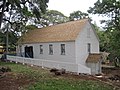
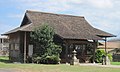
Built in 1910 and accurately restored. The store and the Shinto Shrine next door are all that remains of the Japanese fishing village there prior to World War II. [15] | |
28 | Makawao Union Church | December 17, 1985 (#85003227) | 1445 Baldwin Ave. 20°53′32″N156°21′03″W / 20.892222°N 156.350833°W | Paia | 1916 stone church designed by C. W. Dickey | |
29 | Maui Jinsha Mission | November 21, 1978 (#78001028) | 472 Lipo St. 20°54′29″N156°29′16″W / 20.908056°N 156.487778°W | Wailuku | est. 1915, architect Ichitaro Takata | |
30 | Old Bailey House | ![]() | March 20, 1973 (#73000678) | Iao Valley Rd. 20°53′27″N156°30′37″W / 20.890833°N 156.510278°W | Wailuku | |
31 | Paia School | August 22, 2000 (#00000664) | 955 Baldwin Ave. 20°54′11″N156°21′24″W / 20.903056°N 156.356667°W | Pāʻia | Founded in 1881 as Maui's first all English-speaking school. First principal William Cross refused to learn Hawaiian. 1909 building burned down in 1963. Current main building dates from 1926. Became site of Maui's first public school Hawaiian-immersion program in 1988. [16] | |
32 | Piilanihale Heiau | October 15, 1966 (#66000300) | 4 miles (6.4 km) north of Hana, at the mouth of Honomāʻele Gulch near Kalahu Point 20°47′57″N156°02′18″W / 20.799167°N 156.038333°W | Hana | Within Kahanu Garden | |
33 | Puunene School | August 22, 2000 (#00000663) | East Camp 5 Rd. off Old Puunene Ave. 20°51′44″N156°26′56″W / 20.862222°N 156.448889°W | Puʻnēnē | 1922 school building near sugar mill | |
34 | Wai'ale Drive Bridge | October 30, 1998 (#98001287) | Ka'ahumanu Ave., 0.1 miles (0.16 km) east of Kinipopo St. 20°53′39″N156°30′06″W / 20.894167°N 156.501667°W | Wailuku | ||
35 | Waihee Church | April 21, 1994 (#94000384) | Kahekili Highway 20°56′06″N156°30′54″W / 20.935°N 156.515°W | Waihee | est. 1828 | |
36 | Wailuku Civic Center Historic District | August 20, 1986 (#86001624) | S. High St. between Wells and Kaohu Sts. 20°53′25″N156°30′26″W / 20.890278°N 156.507222°W | Wailuku | 
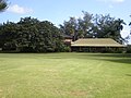
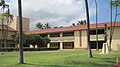
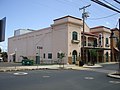
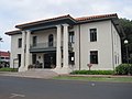
Contributing properties: Old Courthouse (1907, Kerr), Old Police Station (1925, D'Esmond), Wailuku Library (1928, Dickey), Territorial Office Building (1931, Dickey) | |
37 | Wailuku School | June 30, 2000 (#00000666) | 355 S. High St. 20°53′17″N156°30′29″W / 20.888056°N 156.508056°W | Wailuku | est. 1904, [17] architect C. W. Dickey | |
38 | Wananalua Congregational Church | ![]() | November 23, 1988 (#88002533) | Hana Highway and Haouli St. 20°45′07″N155°59′12″W / 20.752002°N 155.986579°W | Hana | |
39 | Wo Hing Society Building | November 15, 1982 (#82000173) | 848 Front St. 20°52′52″N156°40′59″W / 20.881111°N 156.683056°W | Lahaina | In the Lahaina Historic District; Part of the Chinese Tong Houses of Maui Island TR #82000173. |
Kahoolawe is the smallest and the southernmost island of Maui County. Alone among the state's major islands, it is uninhabited.
[6] | Name on the Register | Image | Date listed [7] | Location | Community | Description |
---|---|---|---|---|---|---|
1 | Kahoʻolawe Island Archeological District | ![]() | March 18, 1981 (#81000205) | Kahoolawe 20°33′N156°36′W / 20.55°N 156.6°W | Kahoʻolawe | The district includes the entire island, which contains over 500 individual archeological sites [18] |
The government of the island of Hawaii is Hawaii County, the only county that covers exactly one island, the largest in area in the state. There are 67 properties and districts on the island, including 10 historic districts, six National Historic Landmarks, and one which is a National Historic Landmark District.
Oahu is the third-largest and most populated island of the Hawaiian Islands and of the U.S. state of Hawaii. The state capital, Honolulu, is on Oahu's southeast coast. The island of Oahu and the uninhabited Northwestern Hawaiian Islands constitute the City and County of Honolulu. In 2021, Oahu had a population of 995,638, up from 953,207 in 2010.
Molokai is the fifth most populated of the eight major islands that make up the Hawaiian Islands archipelago in the middle of the Pacific Ocean. It is 38 by 10 miles at its greatest length and width with a usable land area of 260 sq mi (673.40 km2), making it the fifth-largest in size of the main Hawaiian Islands and the 27th largest island in the United States. It lies southeast of Oʻahu across the 25 mi (40 km) wide Kaʻiwi Channel and north of Lānaʻi, separated from it by the Kalohi Channel.
Ancient Hawaiʻi is the period of Hawaiian history preceding the establishment in 1795 of the Kingdom of Hawaiʻi by Kamehameha the Great. Traditionally, researchers estimated the first settlement of the Hawaiian islands as having occurred sporadically between 400 and 1100 CE by Polynesian long-distance navigators from the Samoan, Marquesas, and Tahiti islands within what is now French Polynesia. In 2010, a study was published based on radiocarbon dating of more reliable samples which suggests that the islands were settled much later, within a short timeframe, in about 1219 to 1266.
A heiau is a Hawaiian temple. Made in different architectural styles depending upon their purpose and location, they range from simple earth terraces, to elaborately constructed stone platforms. There are heiau to treat the sick, offer first fruits, offer first catch, start rain, stop rain, increase the population, ensure the health of the nation, achieve success in distant voyaging, reach peace, and achieve success in war (luakini).
Wailua River State Park and the Wailua Complex of Heiaus, which it includes, are located on the eastern side of the Hawaiian island of Kauai. The park consists primarily of the Wailua River valley, which is the only navigable river in Hawaii. Visitors to this park can kayak, take riverboat cruises and explore the rainforest. Even motorboats and water skiing are permissible on the river.
Patrick Vinton Kirch is an American archaeologist and Professor Emeritus of Integrative Biology and the Class of 1954 Professor of Anthropology at the University of California, Berkeley. He is also the former Curator of Oceanic Archaeology in the Phoebe A. Hearst Museum of Anthropology, and director of that museum from 1999 to 2002. Currently, he is professor in the department of anthropology at the University of Hawai'i Manoa, and a member of the board of directors of the Bishop Museum.
Kaniakapūpū, known formerly as Luakaha, is the ruins of the former summer palace of King Kamehameha III and Queen Kalama on the island of Oahu in Hawaii. Built in the 1840s, and situated in the cool uplands of the Nuʻuanu Valley, it served as the king and queen's summer retreat after the capital of the Kingdom of Hawaii moved from Lahaina to Honolulu in 1845. It was famous for being the site of a grand luau attended by an estimated ten thousand guests during the 1847 Hawaiian Sovereignty Restoration Day celebration. The palace had fallen into ruins by 1874; no records exist about its condition in the intervening years. Rediscovered in the 1950s, the site was cleared and efforts were made to stabilize the ruins from further damage by the elements and invasive plant growth. The site remains officially off-limits to the public and trespassers are subjected to citations, although the site is not regularly monitored.
At their peak, there were six Chinese Society Halls on Maui. Operated by the Gee Kung Tong Society, these halls were created to provide services to immigrant Chinese workers, mostly working for the sugarcane plantations. All provided religious and political help, in addition to mutual aid. Only the Wo Hing Society Hall in Lahaina and the Ket Hing Society Hall in Kula have survived. Both were placed on the Hawaii State Register of Historic Places on July 30, 1982, and placed on the National Register of Historic Places on November 15, 1982. The Chee Kung Tong Society Hall was placed onto both State and Federal registers, but collapsed in 1996.
Kīkīaola is a historic irrigation ditch (ʻauwai) located near Waimea on the island of Kauai in the U.S. state of Hawaii. Also known as "Menehune Ditch" or "Peekauai Ditch," it was added to the National Register of Historic Places on November 16, 1984. It is purported to have been built by the Menehune.
Kaunolū Village Site is located on the south coast of the island of Lānaʻi. This former fishing village, abandoned in the 1880s, is the largest surviving ruins of a prehistoric Hawaiian village. The archaeological site is very well preserved and covers almost every phase of Hawaiian culture. It was designated a U.S. National Historic Landmark in 1962 and added to the National Register of Historic Places in 1966.
Halekiʻi-Pihana Heiau State Monument is a 10-acre (4.0 ha) park containing two important luakini heiau on a high ridge near the mouth of ʻIao Stream in Wailuku, Maui. Both Halekiʻi and Pihana were associated with important Hawaiian chiefs, have been closely studied by archaeologists, and overlook the fertile Nā Wai ʻEhā region irrigated by the Wailuku, Waikapu, Waiheʻe and Waiehu streams. The heiau complex was added to the National Register of Historic Places on 25 November 1985.
Agrotis dislocata, the lesser native cutworm, is a moth of the family Noctuidae. It was first described by Francis Walker in 1856. It is endemic to the Hawaiian islands of Niihau, Kauai, Oahu, Molokai, Maui, Lanai, Hawaii and Laysan.
The Kukui Heiau, near Wailua, Hawaii, also known as 'A'A Kukui is a historic archeological site that is listed on the National Register of Historic Places. It is the site of a heiau—a Hawaiian temple—on state land that was donated by neighboring condo developers. It is now landscaped, but retains facing walls and offers a good view of Wailua Bay. A 1.1 acres (0.45 ha) area was listed on the National Register of Historic Places in 1987.
The Haena Archeological Complex, on Kauai near Hanalei, Hawaii, is an archeological site complex that is listed on the U.S. National Register of Historic Places.
The Brick Palace was the first western-style structure built in the Hawaiian Islands for Kamehameha the Great to serve as the first Royal Palace. Lahaina became the seat of government for the Hawaiian Kingdom until 1845. The king commissioned the structure to be built at Keawa'iki point in Lahaina, Maui. Two foreign, ex-convicts from Australia's Botany Bay penal colony built the home. It was begun in 1798 and was completed after 4 years in 1802. The house was intended for Kamehameha's favorite and most powerful wife, Kaahumanu, but she refused to live in the structure and resided instead in a traditional Hawaiian-styled home only feet away.
The 2016 United States House of Representatives elections in Hawaii occurred on November 8, 2016. The electorate chose two candidates to act in the U.S. House, one from each of the state's two districts. Hawaii is one of 14 states that employ an open primary system, meaning voters do not have to state a party affiliation in the election. The primaries were held on August 13.