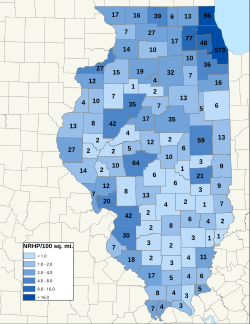
This is a list of properties and districts in Illinois that are on the National Register of Historic Places. There are over 1,900 in total. Of these, 85 are National Historic Landmarks. There are listings in all of the state's 102 counties.
This National Park Service list is complete through NPS recent listings posted January 12, 2024. [1]
[4] | Name on the Register | Image | Date listed [5] | Location | City or town | Description |
---|---|---|---|---|---|---|
1 | Greenville Public Library | August 4, 1995 (#95000991) | 414 W. Main Avenue 38°53′30″N89°24′57″W / 38.891667°N 89.415833°W | Greenville | ||
2 | Old Main, Almira College | April 21, 1975 (#75000638) | 315 E. College St. 38°53′36″N89°24′32″W / 38.893333°N 89.408889°W | Greenville | Hogue Hall at Greenville College. Demolished in 2008. |
[4] | Name on the Register | Image | Date listed [5] | Location | City or town | Description |
---|---|---|---|---|---|---|
1 | Belvidere North State Street Historic District | June 6, 2012 (#12000324) | State Street between Hurlbut Street & Kishwaukee River 42°15′38″N88°50′39″W / 42.260446°N 88.844297°W | Belvidere | ||
2 | Belvidere South State Street Historic District | June 6, 2012 (#12000325) | State Street between Logan Avenue & Madison Street 42°15′21″N88°50′23″W / 42.255777°N 88.839658°W | Belvidere | ||
3 | Belvidere High School | July 25, 1997 (#97000815) | Jct. of Pearl and First Sts. 42°15′17″N88°50′27″W / 42.254722°N 88.840833°W | Belvidere | ||
4 | Lampert-Wildflower House | August 12, 2005 (#05000870) | 410 East Lincoln Avenue 42°15′44″N88°50′28″W / 42.262222°N 88.841111°W | Belvidere | ||
5 | Pettit Memorial Chapel | December 1, 1978 (#78001112) | 1100 N. Main St. 42°16′10″N88°50′50″W / 42.269444°N 88.847222°W | Belvidere | ||
6 | United States Post Office-Belvidere | May 11, 2000 (#00000473) | 200 S. State St. 42°15′28″N88°50′27″W / 42.257778°N 88.840833°W | Belvidere |
[4] | Name on the Register | Image | Date listed [5] | Location | City or town | Description |
---|---|---|---|---|---|---|
1 | La Grange Lock and Dam Historic District | March 10, 2004 (#04000170) | 0.75 miles (1.21 km) south of County Road 795N at the Illinois River 39°56′27″N90°32′02″W / 39.940833°N 90.533889°W | Versailles | ||
2 | Mount Sterling Commercial Historic District | May 8, 1987 (#87000724) | Roughly bounded by Brown Co. Courthouse, Alley E of Capitol, South St., and Alley W of Capitol 39°59′12″N90°45′51″W / 39.986667°N 90.764167°W | Mount Sterling |
[4] | Name on the Register | Image | Date listed | Date removed | Location | City or town | Description |
---|---|---|---|---|---|---|---|
1 | Benjamin Dewitt House | July 28, 1983 (#83000300) | December 8, 1995 | Address Restricted | Versailles |
[4] | Name on the Register | Image | Date listed [5] | Location | City or town | Description |
---|---|---|---|---|---|---|
1 | Beardstown Grand Opera House | May 11, 2000 (#00000471) | 121 State St. 40°01′03″N90°26′03″W / 40.017500°N 90.434167°W | Beardstown | ||
2 | Andrew Cunningham Farm | May 12, 1975 (#75000641) | 2.5 miles east of Virginia off Gridley Rd. 39°57′05″N90°09′30″W / 39.951389°N 90.158333°W | Virginia |
[4] | Name on the Register | Image | Date listed | Date removed | Location | City or town | Description |
---|---|---|---|---|---|---|---|
1 | Park House | February 10, 1983 (#83000304) | December 8, 1995 | 200 W. 2nd St. | Beardstown |
[4] | Name on the Register | Image | Date listed [5] | Location | City or town | Description |
---|---|---|---|---|---|---|
1 | Bolivia Road Bridge | January 28, 2004 (#03001464) | Across the North Fork of the Sangamon River 39°46′03″N89°20′44″W / 39.7675°N 89.3456°W | Bolivia | Extends into Sangamon County | |
2 | Illinois State Bank Building | August 16, 1984 (#84000923) | 201 N. Chestnut St. 39°31′14″N89°02′59″W / 39.5206°N 89.0496°W | Assumption | ||
3 | Louis Jehle House | April 20, 1995 (#95000490) | 511 E. 5th St. 39°23′02″N89°04′33″W / 39.3840°N 89.0758°W | Pana | ||
4 | Kitchell Park | November 5, 1992 (#92001538) | Junction of 9th and Kitchell Sts. 39°22′43″N89°04′47″W / 39.3786°N 89.0797°W | Pana | ||
5 | Taylorville Chautauqua Auditorium | January 21, 1988 (#87002519) | Manners Park 39°32′23″N89°17′45″W / 39.5397°N 89.2958°W | Taylorville | ||
6 | Taylorville Courthouse Square Historic District | December 2, 1985 (#85003058) | Roughly bounded by Vine, Walnut, Adams, and Webster Sts. 39°32′53″N89°17′42″W / 39.5481°N 89.2950°W | Taylorville |
[4] | Name on the Register | Image | Date listed [5] | Location | City or town | Description |
---|---|---|---|---|---|---|
1 | Baltimore and Ohio Railroad Depot | February 20, 1998 (#98000112) | 225 W. Railroad St. 38°40′04″N88°29′18″W / 38.6678°N 88.4883°W | Flora | ||
2 | Clay County Courthouse | May 18, 2015 (#15000224) | 300 Broadway St. 38°46′24″N88°29′55″W / 38.7732°N 88.4985°W | Louisville | ||
3 | Clay County Jail | August 6, 1998 (#98000986) | 195 Main St. 38°46′20″N88°30′03″W / 38.7722°N 88.5008°W | Louisville | ||
4 | Pearl and Bess Meyer House | February 9, 2001 (#01000084) | 233 E. 2nd St. 38°40′14″N88°29′02″W / 38.6706°N 88.4839°W | Flora | ||
5 | Paine House | November 14, 1985 (#85002843) | Rt. 1, Box 19 A 38°38′19″N88°38′05″W / 38.6386°N 88.6347°W | Xenia | ||
6 | Shriver House | May 9, 1983 (#83000306) | 117 E. 3rd St. 38°40′15″N88°29′10″W / 38.6708°N 88.4861°W | Flora |
[4] | Name on the Register | Image | Date listed [5] | Location | City or town | Description |
---|---|---|---|---|---|---|
1 | General Dean Suspension Bridge | April 3, 1973 (#73000693) | E of Carlyle over the Kaskaskia River 38°36′40″N89°21′26″W / 38.6111°N 89.3572°W | Carlyle | ||
2 | James C. Twiss House | February 17, 2010 (#10000020) | 298 N. Page St. 38°36′40″N89°36′22″W / 38.6111°N 89.6060°W | Aviston |
[4] | Name on the Register | Image | Date listed [5] | Location | City or town | Description |
---|---|---|---|---|---|---|
1 | Cumberland County Courthouse | June 11, 1981 (#81000220) | Court House Sq. 39°16′21″N88°14′41″W / 39.2725°N 88.2447°W | Toledo | ||
2 | Greenup Commercial Historic District | February 21, 1991 (#91000083) | 122 E.-123 W. Cumberland Street, 102 N.-203 S. Kentucky Street, 101 N. Mill Street and 101 E.-100 W. Illinois St. 39°14′47″N88°09′51″W / 39.2464°N 88.1642°W | Greenup | ||
3 | Thornton Ward Estate | December 4, 2001 (#01001308) | 1387 U.S. Route 40 39°13′40″N88°12′51″W / 39.2278°N 88.2142°W | Toledo |
[4] | Name on the Register | Image | Date listed [5] | Location | City or town | Description |
---|---|---|---|---|---|---|
1 | Magill House | November 28, 2003 (#03001202) | 100 N. Center St. 40°09′12″N88°57′39″W / 40.1533°N 88.9608°W | Clinton | ||
2 | C. H. Moore House | March 23, 1979 (#79003112) | 219 E. Woodlawn St. 40°09′38″N88°57′29″W / 40.1606°N 88.9581°W | Clinton |
[4] | Name on the Register | Image | Date listed [5] | Location | City or town | Description |
---|---|---|---|---|---|---|
1 | Arcola Carnegie Public Library | May 9, 2002 (#02000459) | 407 E. Main St. 39°41′04″N88°18′12″W / 39.6844°N 88.3033°W | Arcola | ||
2 | Henson House | December 31, 2020 (#100005967) | 103 North Henson Rd. 39°51′48″N88°09′03″W / 39.8634°N 88.1509°W | Villa Grove | ||
3 | Streibich Blacksmith Shop | February 21, 1991 (#91000086) | 1 N. Howard St. 39°47′53″N87°58′58″W / 39.7981°N 87.9828°W | Newman |
[4] | Name on the Register | Image | Date listed | Date removed | Location | City or town | Description |
---|---|---|---|---|---|---|---|
1 | John McCarty Round Barn | December 7, 1982 (#82000394) | December 8, 1995 | Northwest of Filson | Filson |
[4] | Name on the Register | Image | Date listed [5] | Location | City or town | Description |
---|---|---|---|---|---|---|
1 | St. John's Episcopal Church | February 15, 2012 (#12000027) | 20 E. Cherry St. 38°22′32″N88°03′27″W / 38.375556°N 88.057500°W | Albion |
[4] | Name on the Register | Image | Date listed [5] | Location | City or town | Description |
---|---|---|---|---|---|---|
1 | Effingham County Courthouse | September 11, 1985 (#85002304) | 110 E. Jefferson St. 39°07′18″N88°32′28″W / 39.121667°N 88.541111°W | Effingham | ||
2 | Heart Theater | April 12, 2023 (#100008843) | 133 East Jefferson Ave. 39°07′17″N88°32′28″W / 39.1213°N 88.5411°W | Effingham | ||
3 | Dr. Charles M. Wright House | May 8, 1986 (#86001018) | 3 W. Jackson St. 39°03′57″N88°44′53″W / 39.065972°N 88.748056°W | Altamont |
[4] | Name on the Register | Image | Date listed [5] | Location | City or town | Description |
---|---|---|---|---|---|---|
1 | Floyd and Glenora Dycus House | March 2, 2001 (#01000179) | 305 S. Second St. 38°59′41″N88°57′09″W / 38.994722°N 88.952500°W | Brownstown | ||
2 | First Presbyterian Church | March 24, 1982 (#82002534) | 301 W. Main St. 38°57′43″N89°05′37″W / 38.961944°N 89.093611°W | Vandalia | ||
3 | Little Brick House | June 4, 1973 (#73000701) | 621 St. Clair St. 38°57′56″N89°05′54″W / 38.965417°N 89.098333°W | Vandalia | ||
4 | Vandalia Statehouse | January 21, 1974 (#74000760) | 315 W. Gallatin St. 38°57′40″N89°05′38″W / 38.961111°N 89.093889°W | Vandalia |
[4] | Name on the Register | Image | Date listed | Date removed | Location | City or town | Description |
---|---|---|---|---|---|---|---|
1 | Clarence Forehand Round Barn | December 7, 1982 (#82000394) | December 8, 1995 | West of Vandalia off Illinois Route 185 | Vandalia | Destroyed by strong winds, May 26, 1989. | |
2 | PRESIDENT | December 20, 1989 (#89002460) | July 13, 2011 | Scattered over two acres in three separate locations around St. Elmo | St. Elmo | Formerly a National Historic Landmark |
[4] | Name on the Register | Image | Date listed [5] | Location | City or town | Description |
---|---|---|---|---|---|---|
1 | Dunnan-Hampton House | May 22, 2007 (#07000455) | 511 W. Pells St. 40°27′46″N88°06′15″W / 40.462778°N 88.104167°W | Paxton | ||
2 | Paxton Carnegie Public Library | May 9, 2002 (#02000463) | 254 S. Market St. 40°27′38″N88°05′54″W / 40.460556°N 88.098333°W | Paxton | ||
3 | Paxton First Schoolhouse | January 29, 1980 (#80001354) | 406 E. Franklin St. 40°27′17″N88°05′39″W / 40.454861°N 88.094167°W | Paxton | ||
4 | Paxton Water Tower and Pump House | November 13, 1984 (#84000302) | 145 S. Market St. 40°27′36″N88°05′49″W / 40.46°N 88.096944°W | Paxton | ||
5 | Alfred Phillips House | February 5, 1999 (#99000113) | 404 N. Melvin St. 40°28′09″N88°22′13″W / 40.469167°N 88.370278°W | Gibson City |
[4] | Name on the Register | Image | Date listed [5] | Location | City or town | Description |
---|---|---|---|---|---|---|
1 | Franklin County Jail | February 5, 1999 (#99000111) | 209 W. Main St. 37°59′49″N88°55′21″W / 37.996944°N 88.922500°W | Benton | ||
2 | Sesser Opera House | March 12, 1982 (#82002535) | 106 W. Franklin Ave. 38°05′31″N89°03′02″W / 38.091944°N 89.050556°W | Sesser | ||
3 | West Frankfort City Hall | May 9, 2002 (#02000460) | 108 N. Emma St. 37°53′59″N88°55′35″W / 37.899722°N 88.926389°W | West Frankfort |
[4] | Name on the Register | Image | Date listed [5] | Location | City or town | Description |
---|---|---|---|---|---|---|
1 | Cloud State Bank | November 28, 1978 (#78001149) | 108 S. Washington St. 38°05′36″N88°32′12″W / 38.093222°N 88.536667°W | McLeansboro | ||
2 | Aaron G. Cloud House | April 15, 1978 (#78001150) | 164 S. Washington St. 38°05′35″N88°32′12″W / 38.093056°N 88.536667°W | McLeansboro | ||
3 | Chalon Guard and Emma Blades Cloud House | February 18, 2009 (#09000026) | 300 S. Washington St. 38°05′29″N88°32′13″W / 38.091500°N 88.536944°W | McLeansboro | ||
4 | St. James Episcopal Church | January 24, 1995 (#94001602) | 111 N. Pearl St. 38°05′42″N88°32′16″W / 38.095000°N 88.537778°W | McLeansboro |
[4] | Name on the Register | Image | Date listed [5] | Location | City or town | Description |
---|---|---|---|---|---|---|
1 | Battery Rock | November 5, 1998 (#98001257) | West Bank, River Mile 860, Ohio River 37°31′46″N88°04′52″W / 37.529444°N 88.081111°W | Cave-in-Rock | ||
2 | Cave-in-Rock | August 6, 1998 (#98000984) | 0.5 miles north of the town of Cave-In-Rock 37°28′02″N88°09′34″W / 37.467222°N 88.159444°W | Cave-In-Rock | ||
3 | Illinois Iron Furnace | March 7, 1973 (#73000704) | Shawnee National Forest 37°29′58″N88°19′41″W / 37.499444°N 88.327944°W | Near Rosiclare | ||
4 | Orr-Herl Mound and Village Site | November 21, 1978 (#78001151) | Northern bank of the Ohio River midway between Elizabethtown and Rosiclare [6] 37°26′04″N88°19′39″W / 37.43444°N 88.32750°W | Near Rosiclare | ||
5 | Rose Hotel | December 26, 1972 (#72000461) | Main St. 37°26′43″N88°18′16″W / 37.445278°N 88.304444°W | Elizabethtown |
[4] | Name on the Register | Image | Date listed [5] | Location | City or town | Description |
---|---|---|---|---|---|---|
1 | Lock and Dam No. 18 Historic District | March 10, 2004 (#04000178) | 1.5 mi. N of unnamed cty rd. from Gladstone 40°52′55″N91°01′27″W / 40.881944°N 91.024167°W | Gladstone | Extends into Des Moines County, Iowa. | |
2 | Oquawka Wagon Bridge | February 24, 1975 (#75000660) | 2.5 miles (4.0 km) south of Oquawka over Henderson Creek 40°53′39″N90°56′57″W / 40.894167°N 90.949250°W | Oquawka | ||
3 | Alexis Phelps House | April 28, 1982 (#82002537) | On the Mississippi River 40°56′21″N90°57′20″W / 40.939028°N 90.955417°W | Oquawka | ||
4 | South Henderson Church and Cemetery | October 14, 1976 (#76000709) | East of Gladstone 40°52′23″N90°54′48″W / 40.873056°N 90.913333°W | Gladstone |
[4] | Name on the Register | Image | Date listed [5] | Location | City or town | Description |
---|---|---|---|---|---|---|
1 | Glenwood School | May 29, 2020 (#100005232) | 1398 East 800 North Rd. 40°36′08″N87°51′42″W / 40.6021°N 87.8617°W | Cissna Park | ||
2 | Old Iroquois County Courthouse | June 13, 1975 (#75000663) | Cherry Street at 2nd Street 40°46′28″N87°44′09″W / 40.774444°N 87.735833°W | Watseka | ||
3 | Prairie Dell Meetinghouse | August 12, 2005 (#05000846) | Junction of 2550 East and 2150 North Rd. 40°49′34″N87°38′40″W / 40.826111°N 87.644444°W | Iroquois | ||
4 | A. Herr and E. E. Smith Public Library | August 4, 1995 (#95000992) | 105 Adams St. 40°31′04″N88°04′14″W / 40.517778°N 88.070694°W | Loda | ||
5 | St. Mary's Church | May 2, 1996 (#96000514) | 308 St. Charles Avenue 40°57′08″N87°39′09″W / 40.952222°N 87.6525°W | Beaverville | ||
6 | Watseka Union Depot | December 22, 1999 (#99001595) | S. 2nd St. 40°46′32″N87°44′12″W / 40.775417°N 87.736667°W | Watseka | Originally listed in 1988; Ref #88003467. Delisted in early 1999 when it was moved from Cherry Street to current location. |
[4] | Name on the Register | Image | Date listed [5] | Location | City or town | Description |
---|---|---|---|---|---|---|
1 | Embarras River Bridge | May 20, 1998 (#98000472) | Wade Township Road 164 over the Embarras River 38°59′43″N88°09′43″W / 38.995278°N 88.161944°W | Newton |
[4] | Name on the Register | Image | Date listed [5] | Location | City or town | Description |
---|---|---|---|---|---|---|
1 | Appellate Court, 5th District | July 2, 1973 (#73000705) | 14th and Main Sts. 38°19′02″N88°54′30″W / 38.317222°N 88.908333°W | Mount Vernon | ||
2 | C. H. Judd House | December 8, 1983 (#83003571) | Ina-Belle Rive Rd. 38°09′29″N88°45′56″W / 38.158056°N 88.765556°W | Belle Rive |
[4] | Name on the Register | Image | Date listed [5] | Location | City or town | Description |
---|---|---|---|---|---|---|
1 | John Bridges Tavern and Store Site | May 8, 2017 (#100000962) | Illinois Route 146 [7] 37°26′06″N89°00′54″W / 37.435000°N 89.015000°W | Buncombe | ||
2 | John Dupont House | January 19, 2016 (#15000979) | 130 W. 5th St. 37°34′38″N88°46′17″W / 37.577222°N 88.771250°W | New Burnside | ||
3 | Johnson County Courthouse | September 9, 2010 (#10000725) | Courthouse Square 37°24′52″N88°53′48″W / 37.414444°N 88.896528°W | Vienna | ||
4 | Vienna Public Library | January 24, 1995 (#94001603) | 401 Poplar St. 37°24′49″N88°53′47″W / 37.413611°N 88.896389°W | Vienna |
[4] | Name on the Register | Image | Date listed [5] | Location | City or town | Description |
---|---|---|---|---|---|---|
1 | Bridge at 13th Street | April 26, 2016 (#16000198) | 13th St. between Clark and Johnson Sts. 38°35′34″N87°39′12″W / 38.592778°N 87.653333°W | St. Francisville | ||
2 | Lawrence County Courthouse | December 7, 2010 (#10000992) | 1100 State St. 38°43′46″N87°40′56″W / 38.729444°N 87.682222°W | Lawrenceville |
[4] | Name on the Register | Image | Date listed [5] | Location | City or town | Description |
---|---|---|---|---|---|---|
1 | Marshall Site | August 25, 2014 (#14000508) | Address Restricted | Chillicothe | ||
2 | Robert Waugh House | October 4, 1978 (#78001170) | 202 School Street 41°01′45″N89°26′24″W / 41.029167°N 89.44°W | Sparland |
[4] | Name on the Register | Image | Date listed [5] | Location | City or town | Description |
---|---|---|---|---|---|---|
1 | Clear Lake Site | November 28, 1978 (#78001171) | Junction of 1200E and 2600N in Sand Ridge State Park [8] 40°26′08″N89°54′00″W / 40.43555°N 89.90000°W | Manito | Extends into Tazewell County | |
2 | Havana Public Library | February 16, 1994 (#94000014) | 201 W. Adams St. 40°17′57″N90°03′45″W / 40.299167°N 90.062500°W | Havana | ||
3 | Havana Water Tower | April 22, 1993 (#93000325) | Northeastern corner of the junction of Pearl and Main Sts. 40°18′02″N90°03′31″W / 40.300556°N 90.058611°W | Havana | ||
4 | Rockwell Mound | December 10, 1987 (#87000679) | Rockwell Park at the northern end of Orange St. [9] 40°18′18″N90°03′49″W / 40.30500°N 90.06361°W | Havana |
[4] | Name on the Register | Image | Date listed [5] | Location | City or town | Description |
---|---|---|---|---|---|---|
1 | Elijah P. Curtis House | June 9, 1978 (#78001172) | 405 Market St. 37°09′04″N88°44′02″W / 37.151111°N 88.734000°W | Metropolis | ||
2 | Fort Massac Site | July 14, 1971 (#71000293) | Southeast of Metropolis on the Ohio River 37°08′47″N88°42′32″W / 37.146389°N 88.708889°W | Metropolis | ||
3 | Kincaid Site | October 15, 1966 (#66000326) | Newcut Rd. [10] 37°04′50″N88°29′31″W / 37.08055°N 88.49194°W | Brookport | Extends into Pope County |
[4] | Name on the Register | Image | Date listed | Date removed | Location | City or town | Description |
---|---|---|---|---|---|---|---|
1 | R.W. McCartney Music Hall | August 13, 1986 (#86001490) | December 8, 1995 | 116-120 E. 4th St. | Metropolis |
[4] | Name on the Register | Image | Date listed [5] | Location | City or town | Description |
---|---|---|---|---|---|---|
1 | Lincoln's New Salem Village | June 19, 1972 (#72000464) | South of Petersburg in New Salem State Park 39°58′43″N89°50′42″W / 39.978611°N 89.845000°W | Petersburg | ||
2 | North Sangamon United Presbyterian Church | March 23, 1979 (#79000858) | North of Athens on Illinois Route 2 40°00′14″N89°43′23″W / 40.003889°N 89.723056°W | Athens | ||
3 | Petersburg Historic District | June 17, 1976 (#76000722) | Illinois Route 97; also the Smoot Hotel at the corner of 6th and Douglas 40°00′40″N89°51′00″W / 40.011111°N 89.850000°W | Petersburg | Second set of boundaries represents a boundary increase of January 31, 1986 | |
4 | Robinson-Bonnett Inn | August 3, 1990 (#90001198) | Whites Crossing Rd., east of Clary Creek 40°04′31″N89°59′18″W / 40.075278°N 89.988333°W | Bobtown | ||
5 | Col. Matthew Rogers Building | May 22, 2005 (#05000431) | 200 S. Main St. 39°57′36″N89°43′26″W / 39.960000°N 89.723889°W | Athens |
[4] | Name on the Register | Image | Date listed [5] | Location | City or town | Description |
---|---|---|---|---|---|---|
1 | Moultrie County Courthouse | April 20, 1995 (#95000489) | 10 S. Main St. 39°35′57″N88°36′25″W / 39.599167°N 88.606944°W | Sullivan |
[4] | Name on the Register | Image | Date listed [5] | Location | City or town | Description |
---|---|---|---|---|---|---|
1 | Du Quoin State Fairgrounds | July 11, 1990 (#90000719) | U.S. Route 51 north of its junction with Illinois Route 14 37°58′57″N89°13′37″W / 37.9825°N 89.226944°W | Du Quoin | ||
2 | Perry County Jail | August 10, 2000 (#00000943) | 108 W. Jackson St. 38°04′50″N89°23′01″W / 38.080556°N 89.383611°W | Pinckneyville |
[4] | Name on the Register | Image | Date listed [5] | Location | City or town | Description |
---|---|---|---|---|---|---|
1 | Golconda Historic District | October 22, 1976 (#76000726) | Illinois Route 146 37°22′00″N88°29′04″W / 37.366667°N 88.484444°W | Golconda | ||
2 | Kincaid Site | October 15, 1966 (#66000326) | Newcut Rd. [10] 37°04′53″N88°29′22″W / 37.08138°N 88.48944°W | Brookport | Extends into Massac County | |
3 | Millstone Bluff | October 15, 1973 (#73000716) | Illinois Route 147 west of its junction with Illinois Route 145 [11] 37°28′01″N88°41′17″W / 37.46694°N 88.68805°W | Glendale |
[4] | Name on the Register | Image | Date listed [5] | Location | City or town | Description |
---|---|---|---|---|---|---|
1 | Illinois Central Railroad Depot | August 18, 1999 (#99000978) | Junction of Central Avenue and Ullin Avenue 37°16′38″N89°11′05″W / 37.277222°N 89.184861°W | Ullin | ||
2 | Mound City Civil War Naval Hospital | October 9, 1974 (#74002285) | Commercial Avenue and Central Street 37°05′04″N89°09′39″W / 37.084444°N 89.160833°W | Mound City | Destroyed by fire in 1976 | |
3 | Mound City National Cemetery | October 8, 1997 (#97001174) | Junction of U.S. Route 51 and Illinois Route 37 37°05′14″N89°10′41″W / 37.087222°N 89.178056°W | Mound City | ||
4 | Olmstead Depot | December 15, 1989 (#89002101) | Front Street and Caledonia Avenue 37°10′52″N89°05′20″W / 37.181111°N 89.088889°W | Olmsted |
[4] | Name on the Register | Image | Date listed [5] | Location | City or town | Description |
---|---|---|---|---|---|---|
1 | Clear Creek Meeting House | November 5, 1992 (#92001534) | 14365 North 350th Avenue [12] 41°09′16″N89°11′36″W / 41.15444°N 89.19333°W | McNabb | ||
2 | Cortland Condit House | September 16, 1983 (#83000335) | Off Illinois Route 29 41°10′53″N89°23′46″W / 41.181389°N 89.396111°W | Putnam | ||
3 | Edward Pulsifer House | September 4, 1979 (#79000864) | Illinois Route 71 41°15′27″N89°20′27″W / 41.2575°N 89.340833°W | Hennepin | ||
4 | Putnam County Courthouse | March 4, 1975 (#75000672) | 4th St. 41°15′12″N89°20′33″W / 41.253333°N 89.342500°W | Hennepin |
[4] | Name on the Register | Image | Date listed [5] | Location | City or town | Description |
---|---|---|---|---|---|---|
1 | Elliott Street Historic District | November 26, 1980 (#80001405) | S. Elliott Street between Chestnut Street and South Avenue 38°43′32″N88°04′48″W / 38.725556°N 88.080000°W | Olney | ||
2 | Ambrose Hopkinson House | February 9, 2001 (#01000083) | 122 W. Elm St. 38°43′44″N88°05′09″W / 38.728889°N 88.085833°W | Olney | ||
3 | Larchmound | January 3, 1980 (#80001406) | 1030 S. Morgan St. 38°43′11″N88°04′53″W / 38.719722°N 88.081389°W | Olney | ||
4 | Olney Carnegie Library | February 14, 2002 (#02000037) | 401 E. Main St. 38°43′51″N88°04′57″W / 38.730833°N 88.082500°W | Olney |
[4] | Name on the Register | Image | Date listed [5] | Location | City or town | Description |
---|---|---|---|---|---|---|
1 | Carrier Mills Archeological District | August 25, 1978 (#78001184) | Along the Saline River south of Carrier Mills [13] 37°39′28″N88°37′04″W / 37.65777°N 88.61777°W | Carrier Mills | ||
2 | Eldorado City Hall | November 7, 1995 (#95001237) | 1604 Locust St. 37°48′45″N88°26′31″W / 37.812500°N 88.441944°W | Eldorado | ||
3 | Harrisburg City Hall | November 12, 1998 (#98001356) | 110 E. Locust St. 37°44′22″N88°32′20″W / 37.739444°N 88.538889°W | Harrisburg | ||
4 | Saline County Poor Farm | January 22, 2001 (#00001048) | 1600 Feazel Rd. 37°43′08″N88°33′08″W / 37.718889°N 88.552222°W | Harrisburg |
[4] | Name on the Register | Image | Date listed [5] | Location | City or town | Description |
---|---|---|---|---|---|---|
1 | Phoenix Opera House Block | May 9, 1985 (#85001010) | 112-122 W. Lafayette St. 40°07′14″N90°33′47″W / 40.120556°N 90.563056°W | Rushville | ||
2 | White Oak Hall | February 5, 2003 (#02001757) | Southeastern corner of the junction of White Oak and Lower Beardstown Rds. 40°06′32″N90°31′09″W / 40.108889°N 90.519167°W | Rushville |
[4] | Name on the Register | Image | Date listed [5] | Location | City or town | Description |
---|---|---|---|---|---|---|
1 | Naples Archeological District | December 22, 1979 (#79000869) | Eastern bank of the Illinois River south of Naples [14] 39°44′18″N90°37′06″W / 39.73833°N 90.61833°W | Naples | ||
2 | Winchester Historic District | February 14, 1979 (#79000870) | Illinois Route 106 39°37′44″N90°27′19″W / 39.628889°N 90.455278°W | Winchester |
[4] | Name on the Register | Image | Date listed [5] | Location | City or town | Description |
---|---|---|---|---|---|---|
1 | Chicago, Burlington & Quincy Railroad Depot | April 30, 1987 (#87000650) | Williams St. 41°03′41″N89°46′07″W / 41.061389°N 89.768611°W | Wyoming |
[4] | Name on the Register | Image | Date listed [5] | Location | City or town | Description |
---|---|---|---|---|---|---|
1 | Beall-Orr House | February 4, 1994 (#94000028) | 503 Cherry St. 38°24′43″N87°45′30″W / 38.411944°N 87.758333°W | Mt. Carmel |
[4] | Name on the Register | Image | Date listed [5] | Location | City or town | Description |
---|---|---|---|---|---|---|
1 | Louisville and Nashville Depot | March 1, 1985 (#85000496) | 101 E. Railroad St. 38°20′54″N89°22′57″W / 38.348472°N 89.382500°W | Nashville | ||
2 | Original Springs Hotel and Bathhouse | December 22, 1978 (#78001194) | 506 N. Hanover St. 38°26′03″N89°32′55″W / 38.434167°N 89.548611°W | Okawville | ||
3 | Frank Schlosser Complex | August 15, 1983 (#83000337) | W. Walnut St. 38°26′03″N89°33′06″W / 38.434167°N 89.551528°W | Okawville |
[4] | Name on the Register | Image | Date listed [5] | Location | City or town | Description |
---|---|---|---|---|---|---|
1 | G.J. George House | February 9, 2006 (#06000006) | 205 W. Center 38°22′40″N88°21′46″W / 38.377778°N 88.362778°W | Fairfield | ||
2 | Mayberry Mound and Village Site | November 21, 1978 (#78001195) | Northeast of the junction of County Road 900E and the Skillet Fork [15] 38°19′15″N88°31′30″W / 38.32083°N 88.52500°W | Sims | ||
3 | Turney-Hall House | April 19, 2018 (#100002329) | 502 SE 4th St. 38°22′30″N88°21′24″W / 38.3751°N 88.3568°W | Fairfield |
[4] | Name on the Register | Image | Date listed [5] | Location | City or town | Description |
---|---|---|---|---|---|---|
1 | Willis Allen House | February 11, 1982 (#82002606) | 514 S. Market St. 37°43′41″N88°55′39″W / 37.728194°N 88.927500°W | Marion | ||
2 | Goddard Chapel | November 6, 1986 (#86003157) | Rose Hill Cemetery 37°44′35″N88°55′54″W / 37.743194°N 88.931667°W | Marion | ||
3 | Marion Veterans Administration Hospital Historic District | January 9, 2013 (#12001146) | 2401 W. Main St. 37°43′28″N88°57′17″W / 37.724412°N 88.954777°W | Marion | ||
4 | Ed M. Stotlar House | November 21, 2002 (#02001354) | 1304 W. Main St. 37°43′52″N88°56′23″W / 37.731111°N 88.939722°W | Marion | ||
5 | Williamson County Jail | May 30, 2007 (#07000476) | 105 S. Van Buren St. 37°43′49″N88°55′41″W / 37.730278°N 88.928056°W | Marion |
The Mound House is an archeological site located in Greene County, Illinois in the Illinois River floodplain. The site is a multicomponent site; however, the mounds were constructed during the Middle Woodland and are associated with the Havana Hopewell culture. The mound center has two identified mounds.
Clear Lake Site is an archaeological site located in Sand Ridge State Park 6.5 miles (10.5 km) from Manito, Illinois. The site was occupied for the majority of the period from 500 B.C. to 1500 A.D.; cultures which have occupied the site include the Early Woodland, Havana Hopewell, and Mississippian. The site consists of a village area and two burial mounds. University of Chicago archaeologists conducted the first excavations at the site in 1932. Significant further excavations were conducted by George and Ethel Schoenbeck of the Peoria Academy of Science; the couple recovered 24,000 pottery shards from the site which represent every pottery type found in Central Illinois. The Illinois State Museum, which received all artifacts recovered by the Schoenbecks, conducted its own excavations at the site in the 1950s.
This is a list of the National Register of Historic Places listings in Will County, Illinois.
This is a list of the National Register of Historic Places listings in Whiteside County, Illinois.
This is a list of the National Register of Historic Places listings in Fulton County, Illinois.
This is a list of the National Register of Historic Places listings in Madison County, Illinois.
This is a list of the National Register of Historic Places listings in St. Clair County, Illinois.
This is a list of properties on the National Register of Historic Places in Vermilion County, Illinois.
This is a list of the National Register of Historic Places listings in Greene County, Illinois.
This is a list of the National Register of Historic Places listings in White County, Illinois.
This is a list of the National Register of Historic Places listings in Alexander County, Illinois.
This is a list of the National Register of Historic Places listings in Crawford County, Illinois.
This is a list of the National Register of Historic Places listings in Calhoun County, Illinois.
This is a list of the National Register of Historic Places listings in Union County, Illinois.
The Ware Mounds and Village Site (11U31), also known as the Running Lake Site, located west of Ware, Illinois, is an archaeological site comprising three platform mounds and a 160-acre (65 ha) village site. The site was inhabited by the Late Woodland and Mississippian cultures from c. 800 to c. 1300. The village is one of the only Mississippian villages known to have existed in the Mississippi River valley in Southern Illinois. As the village was located near two major sources of chert, which Mississippian cultures used to make agricultural tools, it was likely a trading center for the mineral.
Dogtooth Bend Mounds and Village Site is an archaeological site located on the western shore of Lake Milligan in Alexander County, Illinois. The site includes two mounds and a village site stretching northwest of the mounds. The village was inhabited by Middle Mississippian peoples from roughly 900-1600 A.D. It likely served as a trade hub and a social center for residents of the surrounding farmland. Formal archaeological investigation of the site was initiated in 1950 by Irvin Peithman of Southern Illinois University.
The Orr-Herl Mound and Village Site is an archaeological site located along the Ohio River in Hardin County, Illinois, United States. The site consists of a mound, which includes a sizable midden, and the remains of a village. The village was inhabited from roughly 900 to 1500 AD by Mississippian peoples. The site was an important source of fluorspar, which Mississippian peoples used for carvings and beads. The village was likely a manufacturing site for fluorspar items, which were then traded to other villages; this theory is supported by fluorspar artifacts recovered from the Kincaid Site, a Mississippian chiefdom center on the Ohio River in Illinois.
The Collins Archeological District is a pre-Columbian archaeological site located in Kennekuk County Park in Vermilion County, Illinois. The site dates from the Late Woodland period and was used roughly from 900 to 1100 A.D. The core of the site includes two mounds and a ceremonial area. The inhabitants of the region used the site for ceremonial purposes, and the ceremonies conducted at the site were influenced by Mississippian traditions. The site provides evidence of the spread of Mississippian culture from Cahokia to other peoples and regions.
The Naples Archeological District is an archaeological district located on the east bank of the Illinois River at Naples, Illinois. The district includes sixteen archaeological sites which were primarily occupied during the Woodland period. The area was most active during the Middle Woodland period, when it served as an important trade site in the Hopewell exchange system. Over a dozen mounds are included in the district; these mounds mainly served as burial sites, though a number were used to store refuse. The area also includes several large village sites, as Naples was a habitation site in addition to a trade center.