National Register of Historic Places listings in Jersey County, Illinois

Last updated

Location of Jersey County in Illinois Map of Illinois highlighting Jersey County.svg
Location of Jersey County in Illinois

This is a list of the National Register of Historic Places listings in Jersey County, Illinois.

Contents

This is intended to be a complete list of the properties and districts on the National Register of Historic Places in Jersey County, Illinois, United States. Latitude and longitude coordinates are provided for many National Register properties and districts; these locations may be seen together in a map. [1]

There are 21 properties and districts listed on the National Register in the county.


    This National Park Service list is complete through NPS recent listings posted April 8, 2022. [2]

Map all coordinates using: OpenStreetMap  
Download coordinates as: KML

Current listings

[3] Name on the RegisterImageDate listed [4] Location City or townDescription
1 Charles Brainerd House
Charles Brainerd House Charles brainerd grafton.JPG
Charles Brainerd House
February 5, 1998
(#98000065)
420 E. Main St. (Illinois Route 100)
38°58′19″N90°25′45″W / 38.9719°N 90.4292°W / 38.9719; -90.4292 (Charles Brainerd House)
Grafton
2 Duncan Farm
Duncan Farm Duncan Farm Site.jpg
Duncan Farm
August 24, 1982
(#82002542)
Southern side of Illinois Route 100, ½ mile west of Brussels Ferry [5]
38°58′05″N90°30′49″W / 38.9681°N 90.5136°W / 38.9681; -90.5136 (Duncan Farm)
Grafton
3 Elsah Historic District
Elsah Historic District Mill and Selma, Elsah.jpg
Elsah Historic District
July 27, 1973
(#73000706)
North of the McAdams Highway
38°57′15″N90°21′37″W / 38.9542°N 90.3602°W / 38.9542; -90.3602 (Elsah Historic District)
Elsah
4 Fisher-Chapman Farmstead
Fisher-Chapman Farmstead Image Fisher-Chapman House.jpg
Fisher-Chapman Farmstead
February 15, 2012
(#12000028)
24818 Homeridge Dr.
39°08′29″N90°20′42″W / 39.1414°N 90.3451°W / 39.1414; -90.3451 (Fisher-Chapman Farmstead)
Jerseyville
5 Col. William H. Fulkerson Farmstead
Col. William H. Fulkerson Farmstead Image Faulkerson Mansion.jpg
Col. William H. Fulkerson Farmstead
August 6, 1998
(#98000977)
1510 N. State St. (US Highway 67)
39°08′52″N90°20′54″W / 39.1478°N 90.3483°W / 39.1478; -90.3483 (Col. William H. Fulkerson Farmstead)
Jerseyville
6 Grafton Bank
Grafton Bank Bank grafton.JPG
Grafton Bank
February 16, 1994
(#94000016)
225 E. Main St. (Illinois Route 100)
38°58′10″N90°25′55″W / 38.969444°N 90.431944°W / 38.969444; -90.431944 (Grafton Bank)
Grafton
7 Grafton Boat Works April 5, 2022
(#100007582)
400 Front St.
38°58′07″N90°25′50″W / 38.9687°N 90.4306°W / 38.9687; -90.4306 (Grafton Boat Works)
Grafton
8 Grafton Historic District
Grafton Historic District Main northwest of Maple in Grafton.jpg
Grafton Historic District
February 16, 1994
(#94000020)
105-225 and 24-214 W. Main St. (Illinois Route 100), and stone wharf at Maple St.
38°58′09″N90°26′16″W / 38.9692°N 90.4378°W / 38.9692; -90.4378 (Grafton Historic District)
Grafton
9 Hamilton Primary School
Hamilton Primary School Image The Hamilton Primary School.jpeg
Hamilton Primary School
August 6, 1998
(#98000975)
200 ft. west of the intersection of Otterville and McClusky Rds.
39°03′04″N90°23′50″W / 39.0511°N 90.3973°W / 39.0511; -90.3973 (Hamilton Primary School)
Otterville
10 Jersey County Courthouse
Jersey County Courthouse Jersey, IL County courthouse 19th century.JPG
Jersey County Courthouse
May 8, 1986
(#86001008)
Courthouse Square (bordered by W. Pearl, N. Lafayette, W. Exchange, and N. Washington Streets)
39°07′08″N90°19′44″W / 39.1189°N 90.3289°W / 39.1189; -90.3289 (Jersey County Courthouse)
Jerseyville
11 Jerseyville Downtown Historic District
Jerseyville Downtown Historic District Jerseycourt.png
Jerseyville Downtown Historic District
December 29, 1986
(#86003528)
Roughly bounded by Spruce, N. Lafayette, Prairie, and N. Jefferson Streets
39°07′07″N90°19′41″W / 39.1186°N 90.3281°W / 39.1186; -90.3281 (Jerseyville Downtown Historic District)
Jerseyville
12 Jerseyville First Presbyterian Church February 17, 2021
(#100005968)
400 South State St.
39°07′00″N90°19′33″W / 39.1168°N 90.3259°W / 39.1168; -90.3259 (Jerseyville First Presbyterian Church)
Jerseyville
13 Paris Mason Building
Paris Mason Building Paris Mason Building.jpg
Paris Mason Building
February 16, 1994
(#94000017)
100 N. Springfield St.
38°58′17″N90°27′01″W / 38.9714°N 90.4503°W / 38.9714; -90.4503 (Paris Mason Building)
Grafton
14 John and Amelia McClintock House
John and Amelia McClintock House John and Amelia McClintock House.jpg
John and Amelia McClintock House
February 16, 1994
(#94000019)
321 E. Main St. (Illinois Route 100)
38°58′11″N90°25′49″W / 38.9696°N 90.4304°W / 38.9696; -90.4304 (John and Amelia McClintock House)
Grafton
15 New Piasa Chautauqua Historic District
New Piasa Chautauqua Historic District New Piasa Chautauqua.jpg
New Piasa Chautauqua Historic District
June 15, 1982
(#82002541)
Off McAdams Parkway
38°57′57″N90°23′05″W / 38.9658°N 90.3847°W / 38.9658; -90.3847 (New Piasa Chautauqua Historic District)
Chautauqua
16 Nutwood Site February 9, 1979
(#79003784)
Western side of Illinois Route 100, 500 feet south of the Narrows Creek bridge [6]
39°04′54″N90°33′23″W / 39.0817°N 90.5564°W / 39.0817; -90.5564 (Nutwood Site)
Nutwood
17 Pere Marquette State Park Lodge and Cabins
Pere Marquette State Park Lodge and Cabins Pere Marquette State Park (2151794565).jpg
Pere Marquette State Park Lodge and Cabins
March 4, 1985
(#85002405)
Box 158
38°58′18″N90°32′28″W / 38.9717°N 90.5411°W / 38.9717; -90.5411 (Pere Marquette State Park Lodge and Cabins)
Grafton
18 Principia College Historic District
Principia College Historic District Principia College (2152575562).jpg
Principia College Historic District
April 19, 1993
(#93001605)
River Rd.
38°57′01″N90°21′01″W / 38.9503°N 90.3503°W / 38.9503; -90.3503 (Principia College Historic District)
Elsah
19 Ruebel Hotel
Ruebel Hotel Ruebel Hotel.jpg
Ruebel Hotel
February 16, 1994
(#94000015)
207-215 E. Main St. (Illinois Route 100)
38°58′11″N90°25′56″W / 38.9697°N 90.4322°W / 38.9697; -90.4322 (Ruebel Hotel)
Grafton
20 Slaten-LaMarsh House
Slaten-LaMarsh House LaMarsh house grafton.JPG
Slaten-LaMarsh House
February 16, 1994
(#94000018)
25 E. Main St. (Illinois Route 100)
38°58′10″N90°26′03″W / 38.9694°N 90.4342°W / 38.9694; -90.4342 (Slaten-LaMarsh House)
Grafton
21 Smith-Duncan House and Eastman Barn
Smith-Duncan House and Eastman Barn Pere Marquette, Vadalabene-201405117-112.jpg
Smith-Duncan House and Eastman Barn
November 22, 1999
(#99001379)
Illinois Route 100 at Pere Marquette State Park, 2,000 feet (610 m) west of Deer Lick Hollow
38°58′09″N90°30′43″W / 38.9692°N 90.5119°W / 38.9692; -90.5119 (Smith-Duncan House and Eastman Barn)
Grafton

See also

Related Research Articles

National Register of Historic Places listings in Adams County, Illinois

This is a list of the National Register of Historic Places listings in Adams County, Illinois.

National Register of Historic Places listings in Whiteside County, Illinois

This is a list of the National Register of Historic Places listings in Whiteside County, Illinois.

National Register of Historic Places listings in Fulton County, Illinois

This is a list of the National Register of Historic Places listings in Fulton County, Illinois.

National Register of Historic Places listings in Madison County, Illinois

This is a list of the National Register of Historic Places listings in Madison County, Illinois.

National Register of Historic Places listings in LaSalle County, Illinois

This is a list of the National Register of Historic Places listings in LaSalle County, Illinois.

National Register of Historic Places listings in Peoria County, Illinois Wikipedia list article

This is a list of the National Register of Historic Places listings in Peoria County, Illinois.

National Register of Historic Places listings in Pike County, Illinois

This is a list of the National Register of Historic Places listings in Pike County, Illinois.

National Register of Historic Places listings in Randolph County, Illinois

This is a list of the National Register of Historic Places listings in Randolph County, Illinois.

National Register of Historic Places listings in St. Clair County, Illinois

This is a list of the National Register of Historic Places listings in St. Clair County, Illinois.

National Register of Historic Places listings in Greene County, Illinois

This is a list of the National Register of Historic Places listings in Greene County, Illinois.

National Register of Historic Places listings in Jackson County, Illinois

This is a list of the National Register of Historic Places listings in Jackson County, Illinois.

National Register of Historic Places listings in Kankakee County, Illinois

This is a list of the National Register of Historic Places listings in Kankakee County, Illinois.

National Register of Historic Places listings in Kendall County, Illinois

This is a list of the National Register of Historic Places listings in Kendall County, Illinois.

National Register of Historic Places listings in White County, Illinois

This is a list of the National Register of Historic Places listings in White County, Illinois.

National Register of Historic Places listings in Monroe County, Illinois

This is a list of the National Register of Historic Places listings in Monroe County, Illinois.

National Register of Historic Places listings in Alexander County, Illinois

This is a list of the National Register of Historic Places listings in Alexander County, Illinois.

National Register of Historic Places listings in Gallatin County, Illinois

This is a list of the National Register of Historic Places listings in Gallatin County, Illinois.

National Register of Historic Places listings in Edgar County, Illinois

This is a list of the National Register of Historic Places listings in Edgar County, Illinois.

National Register of Historic Places listings in Crawford County, Illinois

This is a list of the National Register of Historic Places listings in Crawford County, Illinois.

National Register of Historic Places listings in Calhoun County, Illinois

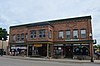
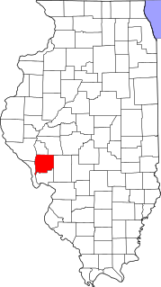
This is a list of the National Register of Historic Places listings in Calhoun County, Illinois.

References

  1. The latitude and longitude information provided in this table was derived originally from the National Register Information System, which has been found to be fairly accurate for about 99% of listings. Some locations in this table may have been corrected to current GPS standards.
  2. National Park Service, United States Department of the Interior, "National Register of Historic Places: Weekly List Actions", retrieved April 8, 2022.
  3. Numbers represent an alphabetical ordering by significant words. Various colorings, defined here, differentiate National Historic Landmarks and historic districts from other NRHP buildings, structures, sites or objects.
  4. The eight-digit number below each date is the number assigned to each location in the National Register Information System database, which can be viewed by clicking the number.
  5. Wagner, Suzanne. National Register of Historic Places Inventory/Nomination: Duncan Farm. National Park Service, 1981-07-30, 5.
  6. Maruszak, Kathleen. National Register of Historic Places Inventory/Nomination: Nutwood Site. National Park Service, 1977-02, 5.