National Register of Historic Places listings in Fulton County, Illinois

Last updated

Location of Fulton County in Illinois Map of Illinois highlighting Fulton County.svg
Location of Fulton County in Illinois

This is a list of the National Register of Historic Places listings in Fulton County, Illinois.

Contents

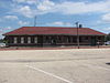
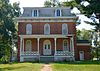
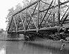
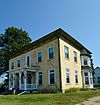
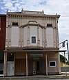
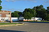
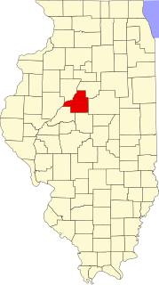
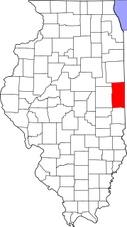
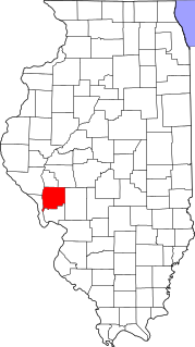
This is intended to be a complete list of the properties and districts on the National Register of Historic Places in Fulton County, Illinois, United States. Latitude and longitude coordinates are provided for many National Register properties and districts; these locations may be seen together in a map. [1]

There are 42 properties and districts listed on the National Register in the county. Another two properties were formerly listed but have been removed.


    This National Park Service list is complete through NPS recent listings posted March 4, 2022. [2]

Map all coordinates using: OpenStreetMap  
Download coordinates as: KML

Current listings

[3] Name on the RegisterImageDate listed [4] Location City or townDescription
1 Babylon Bend Bridge
Babylon Bend Bridge Babylon Bend Bridge.jpg
Babylon Bend Bridge
October 29, 1980
(#80001355)
Illinois Route 123
40°35′25″N90°20′52″W / 40.5903427°N 90.3479107°W / 40.5903427; -90.3479107 (Babylon Bend Bridge)
Ellisville
2 Bernadotte Bridge
Bernadotte Bridge Bernadotte Bridge, Bernadotte Illinois.JPG
Bernadotte Bridge
October 29, 1980
(#80001360)
Illinois Route 2
40°24′13″N90°19′15″W / 40.403611°N 90.320833°W / 40.403611; -90.320833 (Bernadotte Bridge)
Smithfield
3 Buckeye Bridge
Buckeye Bridge VIEW TO NORTHWEST NEAR EAST PORTAL - White's Ferry Bridge, Spanning Spoon River at Township Road 209, Blyton, Fulton County, IL HAER ILL, 29-BLY. V, 1-3.tif
Buckeye Bridge
October 29, 1980
(#80001361)
Spans Spoon River
40°31′54″N90°18′40″W / 40.531667°N 90.311111°W / 40.531667; -90.311111 (Buckeye Bridge)
Smithfield Replaced in 1994
4 Chicago, Burlington and Quincy Railroad Station
Chicago, Burlington and Quincy Railroad Station Chicago, Burlington and Quincy Railroad Depot, Canton, Illinois.JPG
Chicago, Burlington and Quincy Railroad Station
August 31, 1993
(#93000842)
Along 4th Ave. between E. Elm St. and E. Chestnut St.
40°33′23″N90°01′44″W / 40.556389°N 90.028889°W / 40.556389; -90.028889 (Chicago, Burlington and Quincy Railroad Station)
Canton
5 Edith Chipman House
Edith Chipman House Image Chipman House.jpg
Edith Chipman House
November 7, 1996
(#96001290)
201 W. 3rd St.
40°17′43″N90°25′44″W / 40.295278°N 90.428889°W / 40.295278; -90.428889 (Edith Chipman House)
Vermont
6 Dickson Mounds
Dickson Mounds Dickson-museum.jpg
Dickson Mounds
May 5, 1972
(#72000457)
Off County Road 4
40°21′03″N90°06′31″W / 40.350833°N 90.108611°W / 40.350833; -90.108611 (Dickson Mounds)
Lewistown
7 Robert Dilworth House
Robert Dilworth House Robert Dilworth House.jpg
Robert Dilworth House
November 12, 1993
(#93001236)
606 E. 5th St.
40°17′39″N90°25′11″W / 40.294167°N 90.419722°W / 40.294167; -90.419722 (Robert Dilworth House)
Vermont
8 Duncan Mills Bridge October 29, 1980
(#80001356)
West of Havana
40°20′28″N90°11′27″W / 40.341111°N 90.190833°W / 40.341111; -90.190833 (Duncan Mills Bridge)
Lewistown Demolished.
9 William Franklin and Rebecca Durell House
William Franklin and Rebecca Durell House Image Durell House.jpg
William Franklin and Rebecca Durell House
November 7, 1996
(#96001292)
408 W. 5th St.
40°17′38″N90°25′55″W / 40.293889°N 90.431944°W / 40.293889; -90.431944 (William Franklin and Rebecca Durell House)
Vermont
10 Duvall-Ash Farmstead November 12, 1993
(#93001237)
Off Illinois Route 9, 1 mile east and 1.2 miles north of its junction with Illinois Route 97
40°34′40″N90°08′23″W / 40.577778°N 90.139722°W / 40.577778; -90.139722 (Duvall-Ash Farmstead)
Fiatt
11 East Waterford School
East Waterford School East Waterford School.jpg
East Waterford School
November 10, 2009
(#09000897)
Junction of North Dickson Mounds Rd. and East Prairie Rd.
40°20′59″N90°06′55″W / 40.349861°N 90.115278°W / 40.349861; -90.115278 (East Waterford School)
Lewistown
12 Edward Hamer House
Edward Hamer House Image Edward Hamer House.jpg
Edward Hamer House
November 7, 1996
(#96001293)
200 W. 2nd St.
40°17′48″N90°25′45″W / 40.296667°N 90.429167°W / 40.296667; -90.429167 (Edward Hamer House)
Vermont
13 Patterson Hamer House
Patterson Hamer House Image Patterson Hamer House.jpg
Patterson Hamer House
November 7, 1996
(#96001287)
405 W. 5th St.
40°17′36″N90°25′52″W / 40.293333°N 90.431111°W / 40.293333; -90.431111 (Patterson Hamer House)
Vermont
14 William Hoopes House
William Hoopes House Hoopes House2 NRHP 96001285 Fulton County, IL.jpg
William Hoopes House
November 7, 1996
(#96001285)
204 N. Liberty St.
40°17′45″N90°25′44″W / 40.295833°N 90.428889°W / 40.295833; -90.428889 (William Hoopes House)
Vermont
15 Lucinda Hunter House
Lucinda Hunter House Image Hunter House.jpg
Lucinda Hunter House
November 7, 1996
(#96001286)
101 E. 8th St.
40°17′26″N90°25′38″W / 40.290556°N 90.427222°W / 40.290556; -90.427222 (Lucinda Hunter House)
Vermont
16 Indian Ford Bridge
Indian Ford Bridge Fulton County Indian Ford Bridge1.jpg
Indian Ford Bridge
October 29, 1980
(#80001357)
Illinois Route 20
40°41′25″N90°17′24″W / 40.690278°N 90.29°W / 40.690278; -90.29 (Indian Ford Bridge)
London Mills Now demolished.
17 Larson Site
Larson Site Larson Site from the road.jpg
Larson Site
November 21, 1978
(#78001145)
Waterford Rd. north of the Waterford Cemetery [5]
40°20′36″N90°07′52″W / 40.34333°N 90.13111°W / 40.34333; -90.13111 (Larson Site)
Lewistown
18 London Mills Bridge
London Mills Bridge Fulton County London Mills Bridge1.jpg
London Mills Bridge
October 29, 1980
(#80001358)
Illinois Route 39
40°42′36″N90°16′00″W / 40.71°N 90.266667°W / 40.71; -90.266667 (London Mills Bridge)
London Mills Now demolished.
19 Charles Emmor McCormick House
Charles Emmor McCormick House McCormick HouseImage.jpg
Charles Emmor McCormick House
November 7, 1996
(#96001284)
712 W. 3rd St.
40°17′45″N90°26′05″W / 40.295833°N 90.434722°W / 40.295833; -90.434722 (Charles Emmor McCormick House)
Vermont
20 Joab Mershon House
Joab Mershon House Mersin HouseImage.jpg
Joab Mershon House
November 7, 1996
(#96001294)
507 W. 5th St.
40°17′36″N90°25′59″W / 40.293333°N 90.433056°W / 40.293333; -90.433056 (Joab Mershon House)
Vermont
21 Daniel O'Connell House
Daniel O'Connell House Image O'Connell House.jpg
Daniel O'Connell House
November 7, 1996
(#96001288)
115 N. Union St.
40°17′43″N90°25′34″W / 40.295278°N 90.426111°W / 40.295278; -90.426111 (Daniel O'Connell House)
Vermont
22 Oak Hill Cemetery
Oak Hill Cemetery Image Oak Hill Cemetery.jpg
Oak Hill Cemetery
November 13, 1995
(#95001240)
1000 block of N. Main St. (Illinois Routes 97 and 100)
40°24′08″N90°09′24″W / 40.402222°N 90.156667°W / 40.402222; -90.156667 (Oak Hill Cemetery)
Lewistown
23 Odd Fellows Opera Block
Odd Fellows Opera Block Odd Fellows Opera Block.jpg
Odd Fellows Opera Block
August 8, 1996
(#96000876)
Southwestern corner of the junction of Main and Mechanic Sts.
40°37′36″N90°18′16″W / 40.626667°N 90.304444°W / 40.626667; -90.304444 (Odd Fellows Opera Block)
Ellisville
24 Ogden-Fettie Site
Ogden-Fettie Site Dickson-mound.jpg
Ogden-Fettie Site
July 31, 1972
(#72000458)
South of Lewistown
40°20′27″N90°07′06″W / 40.340833°N 90.118333°W / 40.340833; -90.118333 (Ogden-Fettie Site)
Lewistown
25 Orendorf Site September 13, 1977
(#77000484)
Western side of U.S. Route 24 near the northern end of the Duck Creek Cooling Pond [6]
40°29′15″N89°57′06″W / 40.48750°N 89.95166°W / 40.48750; -89.95166 (Orendorf Site)
Canton
26 Ulysses G. Orendorff House
Ulysses G. Orendorff House Image Orendorff House.jpg
Ulysses G. Orendorff House
December 9, 1971
(#71000292)
345 W. Elm St.
40°33′25″N90°02′33″W / 40.556944°N 90.0425°W / 40.556944; -90.0425 (Ulysses G. Orendorff House)
Canton
27 Henry H. Page House
Henry H. Page House Image Page House.jpg
Henry H. Page House
November 7, 1996
(#96001289)
221 N. Union St.
40°17′46″N90°25′34″W / 40.296111°N 90.426111°W / 40.296111; -90.426111 (Henry H. Page House)
Vermont
28 Hiram Palmer House
Hiram Palmer House Hiram Palmer House.jpg
Hiram Palmer House
May 20, 1999
(#99000589)
703 E. Fort St.
40°41′53″N89°59′38″W / 40.698056°N 89.993889°W / 40.698056; -89.993889 (Hiram Palmer House)
Farmington
29 Parlin Library
Parlin Library Parlin Library, Canton, Illinois.JPG
Parlin Library
May 6, 1994
(#94000434)
210 E. Chestnut St.
40°33′24″N90°01′53″W / 40.556667°N 90.031389°W / 40.556667; -90.031389 (Parlin Library)
Canton
30 Harvey Lee Ross House
Harvey Lee Ross House Harvey Lee Ross Farm Residence.jpg
Harvey Lee Ross House
November 7, 1996
(#96001295)
602 S. Main St.
40°17′20″N90°25′41″W / 40.288889°N 90.428056°W / 40.288889; -90.428056 (Harvey Lee Ross House)
Vermont
31 Seville Bridge
Seville Bridge Seville Bridge3 NRHP 80001359 Fulton County, IL.jpg
Seville Bridge
October 29, 1980
(#80001359)
Spans the Spoon River in Seville
40°28′22″N90°17′27″W / 40.472778°N 90.290833°W / 40.472778; -90.290833 (Seville Bridge)
Seville
32 Sheets Site December 22, 1978
(#78001146)
County Road 14, west of Lewistown [7]
40°24′01″N90°12′40″W / 40.40027°N 90.21111°W / 40.40027; -90.21111 (Sheets Site)
Lewistown
33 Sleeth Site
Sleeth Site Sleeth Site from the road.jpg
Sleeth Site
May 17, 1979
(#79000837)
Northeast of the junction of U.S. Route 24 and Pollitt Rd. [8]
40°25′27″N90°00′00″W / 40.42416°N 90.00000°W / 40.42416; -90.00000 (Sleeth Site)
Liverpool
34 Elsworth Snowden House
Elsworth Snowden House Image Snowden House.jpg
Elsworth Snowden House
November 7, 1996
(#96001283)
504 W. 3rd St.
40°17′44″N90°26′00″W / 40.295556°N 90.433333°W / 40.295556; -90.433333 (Elsworth Snowden House)
Vermont
35 South Fulton Churchhouse
South Fulton Churchhouse South Fulton Churchhouse.jpg
South Fulton Churchhouse
October 28, 1994
(#94001264)
2.2 miles south of the junction of Astoria-Bader Rd. and U.S. Route 24
40°11′45″N90°21′26″W / 40.195833°N 90.357222°W / 40.195833; -90.357222 (South Fulton Churchhouse)
Astoria
36 St. James Episcopal Church
St. James Episcopal Church Image St. James.jpg
St. James Episcopal Church
December 31, 1974
(#74000761)
Northeastern corner of the junction of MacArthur and Broadway
40°23′56″N90°09′06″W / 40.398889°N 90.151738°W / 40.398889; -90.151738 (St. James Episcopal Church)
Lewistown
37 Stapleford-Hoover-Whitney House
Stapleford-Hoover-Whitney House Image Whitney House.jpg
Stapleford-Hoover-Whitney House
November 7, 1996
(#96001291)
401 N. Main St.
40°17′51″N90°25′38″W / 40.2975°N 90.427222°W / 40.2975; -90.427222 (Stapleford-Hoover-Whitney House)
Vermont
38 Table Grove Community Church
Table Grove Community Church Table Grove Community Church.jpg
Table Grove Community Church
February 9, 1979
(#79003783)
N. Broadway and W. Liberty Sts.
40°22′00″N90°25′32″W / 40.366667°N 90.425556°W / 40.366667; -90.425556 (Table Grove Community Church)
Table Grove
39 Tampico Mounds May 14, 1979
(#79000838)
West of the junction of U.S. Route 24 and County Road 8 [9]
40°24′58″N90°00′56″W / 40.41611°N 90.01555°W / 40.41611; -90.01555 (Tampico Mounds)
Maples Mill
40 Tartar's Ferry Bridge
Tartar's Ferry Bridge Tarter-ferry-rd-bridge fulton-county-illinois.jpg
Tartar's Ferry Bridge
October 29, 1980
(#80001363)
Spans the Spoon River southwest of Smithfield
40°26′47″N90°21′02″W / 40.446389°N 90.350556°W / 40.446389; -90.350556 (Tartar's Ferry Bridge)
Smithfield
41 Vermont Historic District
Vermont Historic District Vermont State Bank 106 N. Main St.jpg
Vermont Historic District
November 24, 1997
(#97001334)
Roughly bounded by 2nd, Union, 4th, and Liberty Sts.
40°17′42″N90°25′40″W / 40.295075°N 90.427713°W / 40.295075; -90.427713 (Vermont Historic District)
Vermont
42 Vermont Masonic Hall
Vermont Masonic Hall Vermont Masonic Hall.jpg
Vermont Masonic Hall
November 16, 1988
(#88002236)
N. Main St.
40°17′42″N90°25′39″W / 40.295°N 90.4275°W / 40.295; -90.4275 (Vermont Masonic Hall)
Vermont

Former listing

[3] Name on the RegisterImageDate listedDate removedLocationCity or townDescription
1 Carithers Store Building
Carithers Store Building Table Grove square, northwestern quadrant.jpg
Carithers Store Building
August 3, 1987
(#87001262)
January 6, 2020Table Grove village square, west of U.S. Route 136
40°21′58″N90°25′32″W / 40.366096°N 90.4255°W / 40.366096; -90.4255 (Carithers Store Building)
Table Grove
2 Elrod Bridge October 29, 1980
(#80001362)
December 8, 1995Southeast of Smithville spanning the Spoon River
40°23′29″N90°15′16″W / 40.391444°N 90.254556°W / 40.391444; -90.254556 (Elrod Bridge)
Smithfield Destroyed by a tornado in 1995.

See also

Related Research Articles

National Register of Historic Places listings in Illinois

This is a list of properties and districts in Illinois that are on the National Register of Historic Places. There are over 1,900 in total. Of these, 85 are National Historic Landmarks. There are listings in all of the state's 102 counties.
     This National Park Service list is complete through NPS recent listings posted March 4, 2022.

National Register of Historic Places listings in Will County, Illinois

This is a list of the National Register of Historic Places listings in Will County, Illinois.

National Register of Historic Places listings in Adams County, Illinois

This is a list of the National Register of Historic Places listings in Adams County, Illinois.

National Register of Historic Places listings in Whiteside County, Illinois

This is a list of the National Register of Historic Places listings in Whiteside County, Illinois.

National Register of Historic Places listings in Madison County, Illinois

This is a list of the National Register of Historic Places listings in Madison County, Illinois.

National Register of Historic Places listings in Jersey County, Illinois

This is a list of the National Register of Historic Places listings in Jersey County, Illinois.

National Register of Historic Places listings in Randolph County, Illinois

This is a list of the National Register of Historic Places listings in Randolph County, Illinois.

National Register of Historic Places listings in St. Clair County, Illinois

This is a list of the National Register of Historic Places listings in St. Clair County, Illinois.

National Register of Historic Places listings in Tazewell County, Illinois

This is a list of the National Register of Historic Places listings in Tazewell County, Illinois.

National Register of Historic Places listings in Vermilion County, Illinois

This is a list of properties on the National Register of Historic Places in Vermilion County, Illinois.

National Register of Historic Places listings in Greene County, Illinois

This is a list of the National Register of Historic Places listings in Greene County, Illinois.

National Register of Historic Places listings in Kendall County, Illinois

This is a list of the National Register of Historic Places listings in Kendall County, Illinois.

National Register of Historic Places listings in White County, Illinois

This is a list of the National Register of Historic Places listings in White County, Illinois.

National Register of Historic Places listings in Alexander County, Illinois

This is a list of the National Register of Historic Places listings in Alexander County, Illinois.

National Register of Historic Places listings in Crawford County, Illinois

This is a list of the National Register of Historic Places listings in Crawford County, Illinois.

National Register of Historic Places listings in Calhoun County, Illinois

This is a list of the National Register of Historic Places listings in Calhoun County, Illinois.

National Register of Historic Places listings in Union County, Illinois

This is a list of the National Register of Historic Places listings in Union County, Illinois.

Sleeth Site United States historic place

The Sleeth Site is an archaeological site located near Liverpool in Fulton County, Illinois. The side encompasses a 10-acre (4.0 ha) village area including a sizable midden. The site was occupied by people of the Spoon River Culture, a local culture within the Middle Mississippian culture; it is the only known site within the Sleeth Phase of the culture and has been dated to 1500 A.D. Cultural artifacts recovered from the site include many projectile points and pottery shards from jars, plates, and bowls.

The Sheets Site is a prehistoric archaeological site located in Fulton County, Illinois, near the city of Lewistown. The site was occupied from roughly 700 to 400 B.C., spanning the Late Archaic and Early Woodland periods. Its inhabitants were part of the Marion Culture, a culture which lived in much of northern Illinois and neighboring states at the time; it can be identified as such by the presence of Kramer projectile points and Marion Thick pottery, the latter of which is the oldest known type of pottery found in Illinois. Firepits and hearths have also been found at the site, providing potential insight into the diet and subsistence methods of the Marion Culture.

References

  1. The latitude and longitude information provided in this table was derived originally from the National Register Information System, which has been found to be fairly accurate for about 99% of listings. Some locations in this table may have been corrected to current GPS standards.
  2. National Park Service, United States Department of the Interior, "National Register of Historic Places: Weekly List Actions", retrieved March 4, 2022.
  3. 1 2 Numbers represent an alphabetical ordering by significant words. Various colorings, defined here, differentiate National Historic Landmarks and historic districts from other NRHP buildings, structures, sites or objects.
  4. The eight-digit number below each date is the number assigned to each location in the National Register Information System database, which can be viewed by clicking the number.
  5. Maruszak, Kathleen. National Register of Historic Places Inventory/Nomination: Larson Site. National Park Service, 1977-09, 6.
  6. Maruszak, Kathleen. National Register of Historic Places Inventory/Nomination: Orendorf Site. National Park Service, 1976-11-09, 2.
  7. Maruszak, Kathleen, and Debi A. Jones. National Register of Historic Places Inventory/Nomination: Sheets Site. National Park Service, 1978-06, 2.
  8. Maruszak, Kathleen, and Debi A. Jones. National Register of Historic Places Inventory/Nomination: Sleeth Site. National Park Service, 1978-09, 4.
  9. Maruszak, Kathleen, and Debi A. Jones. National Register of Historic Places Inventory/Nomination: Tampico Mounds. National Park Service, 1978-09, 5.