National Register of Historic Places listings in Jo Daviess County, Illinois

Last updated

Location of Jo Daviess County in Illinois Map of Illinois highlighting Jo Daviess County.svg
Location of Jo Daviess County in Illinois

This is a list of the National Register of Historic Places listings in Jo Daviess County, Illinois.

Contents

This is intended to be a complete list of the properties and districts on the National Register of Historic Places in Jo Daviess County, Illinois, United States. Latitude and longitude coordinates are provided for many National Register properties and districts; these locations may be seen together in a map. [1]

There are 18 properties and districts listed on the National Register in the county.


    This National Park Service list is complete through NPS recent listings posted August 26, 2022. [2]

Map all coordinates using: OpenStreetMap  
Download coordinates as: KML

Current listings

[3] Name on the RegisterImageDate listed [4] Location City or townDescription
1 Apple River Fort Site
Apple River Fort Site Elizabeth Il Apple River Fort2.JPG
Apple River Fort Site
November 7, 1997
(#97001332)
0.25 miles east-southeast of the junction of Mrytle and Illinois Sts.
42°19′05″N90°12′51″W / 42.318056°N 90.214167°W / 42.318056; -90.214167 (Apple River Fort Site)
Elizabeth
2 Bishop's Busy Big Store-Lyric Opera House August 15, 2022
(#100008001)
137 North Main St.
42°19′05″N90°13′17″W / 42.3181°N 90.2215°W / 42.3181; -90.2215 (Bishop's Busy Big Store-Lyric Opera House)
Elizabeth
3 John Chapman Village Site
John Chapman Village Site Wapello Land and Water Reserve.jpg
John Chapman Village Site
December 10, 2009
(#09001058)
Western side of Illinois Route 84, south of Hanover [5]
42°14′33″N90°16′03″W / 42.24250°N 90.26750°W / 42.24250; -90.26750 (John Chapman Village Site)
Hanover
4 Chicago Great Western Railroad Depot
Chicago Great Western Railroad Depot Elizabeth Il Chicago Great Western Depot1.JPG
Chicago Great Western Railroad Depot
February 16, 1996
(#96000098)
Myrtle St. between N. Madison and Vine Sts.
42°19′01″N90°13′21″W / 42.316944°N 90.2225°W / 42.316944; -90.2225 (Chicago Great Western Railroad Depot)
Elizabeth
5 East Dubuque School
East Dubuque School East Dubuque IL E Dubuque School1.JPG
East Dubuque School
November 12, 1982
(#82000396)
Montgomery Ave.
42°29′38″N90°38′29″W / 42.493889°N 90.641389°W / 42.493889; -90.641389 (East Dubuque School)
East Dubuque
6 Henry N. Frentess Farmstead
Henry N. Frentess Farmstead Image Frentess House.jpeg
Henry N. Frentess Farmstead
February 4, 2011
(#10001202)
19140 U.S. Route 20 W.
42°28′20″N90°36′30″W / 42.472222°N 90.608333°W / 42.472222; -90.608333 (Henry N. Frentess Farmstead)
East Dubuque
7 Galena Historic District
Galena Historic District Main Street westview Galena Illinois P2140173 House w Pine Tree.jpg
Galena Historic District
October 18, 1969
(#69000056)
Roughly bounded by Davis Creek and 4th, 5th, Adams, Field, Wann, N. Dodge, Fulton, N. Hickory, Hill, Ridge, and Spring Sts.
42°25′06″N90°25′40″W / 42.418333°N 90.427778°W / 42.418333; -90.427778 (Galena Historic District)
Galena Boundary increase and decrease October 23, 2013.
8 Ulysses S. Grant House
Ulysses S. Grant House USGrantHomeGalena.jpg
Ulysses S. Grant House
October 15, 1966
(#66000322)
511 Bouthillier St.
42°24′40″N90°25′27″W / 42.411111°N 90.424167°W / 42.411111; -90.424167 (Ulysses S. Grant House)
Galena
9 Henry W. Miller House
Henry W. Miller House Image Miller House.jpeg
Henry W. Miller House
October 13, 2010
(#10000836)
11672 W. Norris Ln.
42°26′48″N90°27′36″W / 42.446667°N 90.46°W / 42.446667; -90.46 (Henry W. Miller House)
Galena
10 Millville Town Site
Millville Town Site Apple River IL Millville Town Site2.JPG
Millville Town Site
March 3, 2003
(#03000066)
Apple River Canyon State Park, 8663 E. Canyon Rd.
42°26′36″N90°03′07″W / 42.443333°N 90.051944°W / 42.443333; -90.051944 (Millville Town Site)
Apple River
11 Old Market House
Old Market House Galena IL Old Market House1.JPG
Old Market House
July 16, 1973
(#73000707)
Market Square-Commerce St.
42°24′56″N90°25′38″W / 42.415556°N 90.427222°W / 42.415556; -90.427222 (Old Market House)
Galena
12 Old Stone Hotel
Old Stone Hotel Warren IL Old Stone Hotel1.JPG
Old Stone Hotel
April 16, 1975
(#75000665)
110 W. Main St.
42°29′50″N89°59′28″W / 42.497222°N 89.991111°W / 42.497222; -89.991111 (Old Stone Hotel)
Warren
13 Scales Mound Historic District
Scales Mound Historic District Scales Mound IL Scales Mound Historic District Wm Atkinson House1.JPG
Scales Mound Historic District
September 5, 1990
(#90001199)
Roughly bounded by the village limits
42°28′55″N90°15′10″W / 42.481944°N 90.252778°W / 42.481944; -90.252778 (Scales Mound Historic District)
Scales Mound
14 Townsend House
Townsend House Stockton IL Townsend Home2.JPG
Townsend House
May 17, 2005
(#05000111)
117 N. Canyon Park Rd.
42°22′26″N90°03′03″W / 42.373889°N 90.050833°W / 42.373889; -90.050833 (Townsend House)
Stockton
15 Warren Commercial Historic District
Warren Commercial Historic District Gidonb Warren 2.jpg
Warren Commercial Historic District
November 7, 1995
(#95001241)
102-165 E. Main St., 204-210 E. Bunett, 102-108 S. Railroad
42°29′45″N89°59′15″W / 42.495833°N 89.9875°W / 42.495833; -89.9875 (Warren Commercial Historic District)
Warren
16 Elihu Benjamin Washburne House
Elihu Benjamin Washburne House Galena IL Elihu B. Washburne House1.JPG
Elihu Benjamin Washburne House
July 5, 1973
(#73000708)
908 3rd St.
42°24′50″N90°25′54″W / 42.413889°N 90.431667°W / 42.413889; -90.431667 (Elihu Benjamin Washburne House)
Galena
17 Charles Wenner House
Charles Wenner House Wenner House in autumn.jpg
Charles Wenner House
August 22, 1984
(#84001073)
Rocky Rd.
42°27′40″N90°24′39″W / 42.461111°N 90.410833°W / 42.461111; -90.410833 (Charles Wenner House)
Galena
18 W.E. White Building
W.E. White Building Stockton IL W.E. White Bldg1.JPG
W.E. White Building
November 7, 1997
(#97001339)
100 N. Main St.
42°21′00″N90°00′24″W / 42.35°N 90.006667°W / 42.35; -90.006667 (W.E. White Building)
Stockton

See also

Related Research Articles

<span class="mw-page-title-main">National Register of Historic Places listings in Winnebago County, Illinois</span>

This is a list of the National Register of Historic Places listings in Winnebago County, Illinois.

National Register of Historic Places listings in Dubuque County, Iowa

This is a list of the National Register of Historic Places listings in Dubuque County, Iowa.

National Register of Historic Places listings in Jackson County, Iowa

This is a list of the National Register of Historic Places listings in Jackson County, Iowa.

<span class="mw-page-title-main">National Register of Historic Places listings in Champaign County, Illinois</span>

This is intended to be a complete list of the properties and districts on the National Register of Historic Places in Champaign County, Illinois, United States. Latitude and longitude coordinates are provided for many National Register properties and districts; these locations may be seen together in a map.

<span class="mw-page-title-main">National Register of Historic Places listings in Henry County, Illinois</span>

This is a list of the National Register of Historic Places listings in Henry County, Illinois.

<span class="mw-page-title-main">National Register of Historic Places listings in Jackson County, Illinois</span>

This is a list of the National Register of Historic Places listings in Jackson County, Illinois.

<span class="mw-page-title-main">National Register of Historic Places listings in Logan County, Illinois</span>

This is a list of the National Register of Historic Places listings in Logan County, Illinois.

<span class="mw-page-title-main">National Register of Historic Places listings in Warren County, Illinois</span>

This is a list of the National Register of Historic Places listings in Warren County, Illinois.

National Register of Historic Places listings in Daviess County, Indiana

This is a list of the National Register of Historic Places listings in Daviess County, Indiana.

National Register of Historic Places listings in Dubois County, Indiana

This is a list of the National Register of Historic Places listings in Dubois County, Indiana.

National Register of Historic Places listings in Greene County, Indiana

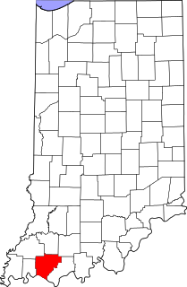
This is a list of the National Register of Historic Places listings in Greene County, Indiana.

National Register of Historic Places listings in Knox County, Indiana

This is a list of the National Register of Historic Places listings in Knox County, Indiana.

National Register of Historic Places listings in Pike County, Indiana

This is a list of the National Register of Historic Places listings in Pike County, Indiana.

National Register of Historic Places listings in Spencer County, Indiana

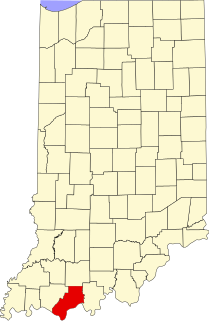
This is a list of the National Register of Historic Places listings in Spencer County, Indiana.

National Register of Historic Places listings in Warrick County, Indiana

This is a list of the National Register of Historic Places listings in Warrick County, Indiana.

National Register of Historic Places listings in Martin County, Indiana

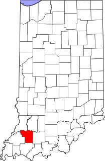
This is a detailed table of the National Register of Historic Places listing in Martin County, Indiana.

<span class="mw-page-title-main">National Register of Historic Places listings in Mercer County, Illinois</span>

This is a list of the National Register of Historic Places listings in Mercer County, Illinois.

<span class="mw-page-title-main">National Register of Historic Places listings in Clark County, Illinois</span>

This is a list of the National Register of Historic Places listings in Clark County, Illinois.

<span class="mw-page-title-main">National Register of Historic Places listings in Woodford County, Illinois</span>

This is a list of the National Register of Historic Places listings in Woodford County, Illinois.

<span class="mw-page-title-main">National Register of Historic Places listings in Knox County, Illinois</span>

This is a list of the National Register of Historic Places listings in Knox County, Illinois.

References

  1. The latitude and longitude information provided in this table was derived originally from the National Register Information System, which has been found to be fairly accurate for about 99% of listings. Some locations in this table may have been corrected to current GPS standards.
  2. National Park Service, United States Department of the Interior, "National Register of Historic Places: Weekly List Actions", retrieved August 26, 2022.
  3. Numbers represent an alphabetical ordering by significant words. Various colorings, defined here, differentiate National Historic Landmarks and historic districts from other NRHP buildings, structures, sites or objects.
  4. The eight-digit number below each date is the number assigned to each location in the National Register Information System database, which can be viewed by clicking the number.
  5. "Grant Propoosal: Wapello Land & Water Reserve Habitat Restoration Project Archived 2008-04-23 at the Wayback Machine ". Illinois Department of Natural Resources, 2006, 2/18.