The Chicago metropolitan area, also referred to as the Greater Chicago Area and Chicagoland, is the largest metropolitan statistical area in the U.S. state of Illinois, and the Midwest, containing the City of Chicago along with its surrounding suburbs and satellite cities. Encompassing 10,286 square mi (28,120km2), the metropolitan area includes the city of Chicago, its suburbs and hinterland, that span 14 counties across northeast Illinois, northwest Indiana, and southeast Wisconsin. The MSA had a 2020 census population of 9,618,502 and the combined statistical area which spans up to 19 counties had a population of nearly 10 million people.[5][6] The Chicago area is the third largest metropolitan area in the United States and the fourth largest metropolitan area in North America (after the metro areas of Mexico City, New York City, and Los Angeles), and the largest in the Great Lakes megalopolis. Its urban area is one of the forty largest in the world.
According to the 2020 Census, the metropolitan's population is approaching the 10 million mark. The metropolitan area has seen a substantial increase of Latin American residents on top of its already large Latino population, and the Asian American population also increased according to the 2020 Census. The metro area has a large number of White, Black, Latino, Asian, and Arab American residents, and also has Native American residents in the region, making the Chicago metropolitan area population truly diverse. The Chicago metropolitan area represents about 3 percent of the entire US population.
Chicagoland has one of the world's largest and most diversified economies. With more than six million full and part-time employees, the Chicago metropolitan area is a key factor of the Illinois economy, as the state has an annual GDP of over $1 trillion.[7] The Chicago metropolitan area generated an annual gross regional product (GRP) of approximately $700 billion in 2018.[8] The region is home to more than 400 major corporate headquarters, including 31 in the Fortune 500[9] such as McDonald's, United, and Blue Cross Blue Shield. With many companies moving to Chicagoland, and many current companies expanding, the area ranked as the nation's top metropolitan area for corporation relocations and expansions for nine consecutive years, the most consecutive years for any region in the country.[10]
There are many transportation options around the region. Chicagoland has three separate rail networks; the Chicago Transit Authority (CTA), Metra, and the South Shore Line. The CTA operates elevated and subway lines that run primarily throughout the city, Downtown Chicago, and into some suburbs. The CTA operates some of its rail lines 24 hours a day, every day of the year, nonstop service, making Chicago, New York City, and Copenhagen the only three cities in the world to offer some 24 hour rail service running nonstop, everyday throughout their city limits. The Metra commuter rail network runs numerous lines between Downtown Chicago and suburban/satellite cities, with one line stretching to Kenosha, Wisconsin, which is part of the Chicago metropolitan area. The interurban South Shore Line runs between Downtown Chicago and the northwest Indiana portion of the metropolitan area. In addition, Amtrak operates Union Station in Downtown Chicago as one of its largest rail hubs, with numerous lines radiating to and from the station.
CTA bus routes serve the city proper, with some service into the suburbs. Pace bus routes serve the suburbs, with some service into the city. In addition, numerous CTA bus routes operate 24 hours a day, nonstop.
Definitions
Chicago Metropolitan statistical area
The Chicago–Naperville, IL–IN–WI Combined Statistical Area as defined by the U.S. Office of Management and Budget:
Chicago–Naperville–Elgin, IL–IN–WI MSA
Michigan City–La Porte, IN MSA
Kankakee, IL MSA
Ottawa, IL MSA
The Chicago metropolitan statistical area (MSA) was originally designated by the United States Census Bureau in 1950. It comprised the Illinois counties of Cook, DuPage, Kane, Lake and Will, along with Lake County in Indiana. As surrounding counties saw an increase in their population densities and the number of their residents employed within Cook County, they met Census criteria to be added to the MSA. The Chicago MSA, now defined by the U.S. Office of Management and Budget (OMB) as the Chicago–Naperville–Elgin, IL–IN–WI Metropolitan Statistical Area, is the third largest MSA by population in the United States. The 2022 census estimate for the population of the MSA was 9,441,957.[11]
The Chicago MSA is further subdivided into four metropolitan divisions. A breakdown of the county constituents and 2021 estimated populations of the four metropolitan divisions of the MSA are as follows:[11]
Chicago–Naperville–Elgin, IL–IN–WI Metropolitan Statistical Area (9,509,934)
Chicago–Naperville–Schaumburg, IL Metropolitan Division (7,159,394)
The OMB also defines a slightly larger region as a Combined Statistical Area (CSA). The Chicago–Naperville, IL–IN–WI Combined Statistical Area combines the following core-based statistical areas, listed with their 2021 estimated populations. The combined statistical area as a whole had a population of 9,806,184 as of 2022.[11]
Chicago–Naperville–Elgin, IL–IN–WI metropolitan statistical area (9,509,934)
Kankakee, IL metropolitan statistical area (106,601)
The Chicago urban agglomeration, according to the United NationsWorld Urbanization Prospects report (2023 revision), lists a population of 8,937,000.[12] The term "urban agglomeration" refers to the population contained within the contours of a contiguous territory inhabited at urban density levels. It usually incorporates the population in a city, plus that in the contiguous urban, or built-up area.
Chicagoland
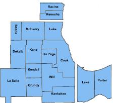
Chicagoland by county and stateA map of Chicagoland in relation to the states of Wisconsin, Illinois, and Indiana
Chicagoland is an informal name for the Chicago metropolitan area. The term Chicagoland has no official definition, and the region is often considered to include areas beyond the corresponding MSA, as well as portions of the greater CSA.[citation needed]
Colonel Robert R. McCormick, editor and publisher of the Chicago Tribune, usually gets credit for placing the term in common use.[14][15] McCormick's conception of Chicagoland stretched all the way to nearby parts of four states (Indiana, Wisconsin, Michigan, and Iowa).[14] The first usage was in the Tribune's July 27, 1926, front page headline, "Chicagoland's Shrines: A Tour of Discoveries", for an article by reporter James O'Donnell Bennett.[16] He stated that Chicagoland comprised everything in a 200-mile (320km) radius in every direction and reported on many different places in the area. The Tribune was the dominant newspaper in a vast area stretching to the west of the city, and that hinterland was closely tied to the metropolis by rail lines and commercial links.[17]
Today, the Chicago Tribune's usage includes the city of Chicago, the rest of Cook County, eight nearby Illinois counties (Lake, McHenry, DuPage, Kane, Kendall, Grundy, Will, and Kankakee), and the two Indiana counties of Lake and Porter.[18] Illinois Department of Tourism literature uses Chicagoland for suburbs in Cook, Lake, DuPage, Kane, and Will counties,[19] treating the city separately. The Chicagoland Chamber of Commerce defines it as all of Cook, DuPage, Kane, Lake, McHenry, and Will counties.[20]
The term "collar counties" is a colloquialism for the five counties (DuPage, Kane, Lake, McHenry, and Will) of Illinois that border Chicago's Cook County. After Cook County, they are also the next five most populous counties in the state. According to the Encyclopedia of Chicago, there is no specifically known origin of the phrase, but it has been commonly used among policy makers, urban planners, and in the media. However, it also notes that as growth has spread beyond these counties, it may have lost some of its usefulness.[22]
Chicago Metropolitan Agency for Planning (CMAP) is an Illinois state agency responsible for transportation infrastructure, land use, and long-term economic development planning for the areas under its jurisdiction within Illinois.[23] The planning area has a population of over 8 million, which includes the following locations in Illinois:[24]
The city of Chicago lies in the Chicago Plain, a flat and broad area characterized by little topographical relief. The few low hills are sand ridges. North of the Chicago Plain, steep bluffs and ravines run alongside Lake Michigan.
Along the southern shore of the Chicago Plain, sand dunes run alongside the lake. The tallest dunes reach up to near 200 feet (61m) and are found in Indiana Dunes National Park. Surrounding the low plain are bands of moraines in the south and west suburbs. These areas are higher and hillier than the Chicago Plain. A continental divide, separating the Mississippi River watershed from that of the Great Lakes and Saint Lawrence River, runs through the Chicago area.
A 2012 survey of the urban trees and forests in the seven county Illinois section of the Chicago area found that 21% of the land is covered by the tree and shrub canopy, made up of about 157,142,000 trees. The five most common tree species are buckthorn, green ash, boxelder, black cherry, and American elm. These resources perform important functions in carbon storage, water recycling, and energy saving.[25][26]
Night aerial view of Chicago and vicinity
Demographics
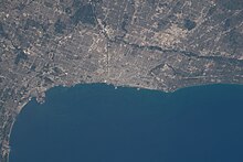
Taken from the ISS on June 23, 2022; downtown Chicago is at the center by the lake.
As of 2022, the metropolitan area had a population of 9,442,159. The population density was 1,312.3 per square mile. The racial makeup was 50.1% Non-Hispanic White, 23.4% were Hispanic, 15.5% were Non-Hispanic African Americans, 7.2% were Asian, 0.1% were Non-Hispanic Native American, 0.4% identified as “some other race,” and 3.2% were non-Hispanic multiracial.[27]
The suburbs, surrounded by easily annexed flat ground, have been expanding at a tremendous rate since the early 1960s. Aurora, Elgin, Joliet, and Naperville are noteworthy for being four of the few boomburbs outside the Sun Belt, West Coast and Mountain States regions, and exurban Kendall County ranked as the fastest-growing county (among counties with a population greater than 10,000) in the United States between the years 2000 and 2007.[32]
Settlement patterns in the Chicago metropolitan area tend to follow those in the city proper: the northern and northwestern suburbs are generally affluent and upper-middle class, while the southern suburbs (sometimes known as Chicago Southland) have somewhat lower median incomes and a cost of living, with the exception being the southwest suburbs which contain many upper-middle class areas. Another exception to this is the West Side, which has a somewhat lower median income, but the western suburbs contain many affluent and upper-middle class areas. According to the 2000 Census, DuPage County as a whole had the highest median household income of any county in the Midwestern United States, although there are individual cities and towns in other surrounding counties in the metro that have even higher median incomes.
According to 2022 estimates from the U.S. Census, poverty rates of the largest counties from least poverty to most are as follows: McHenry 4.0%, Dupage 6.7%, Will 6.9%, Kane 7.8%, Lake 8.0%, and Cook 13.6%.[33] However, Cook County, which contains luxury high rises and expensive houses in sections of the city and expensive houses along the waterfront in the North Shore area, would also have the highest percentage of expensive homes in the region.
In an in-depth historical analysis, Keating (2004, 2005) examined the origins of 233 settlements that by 1900 had become suburbs or city neighborhoods of the Chicago metropolitan area. The settlements began as farm centers (41%), industrial towns (30%), residential railroad suburbs (15%), and recreational/institutional centers (13%). Although relations between the different settlement types were at times contentious, there also was cooperation in such undertakings as the construction of high schools.[citation needed]
Population
As the Chicago metropolitan area has grown, more counties have been partly or totally assimilated with the taking of each decennial census.
Counties highlighted in gray were not included in the MSA for that census. The CSA totals in blue are the totals of all the counties listed above, regardless of whether they were included in the Chicago Combined Statistical Area at the time.[34]
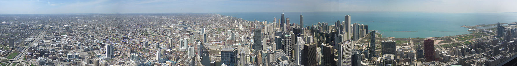
View of Chicago greater metropolitan region and the North branch of the Chicago River from the Willis Tower
Urban areas within
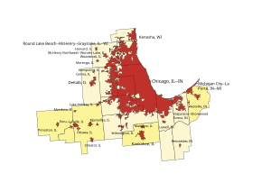
Within the boundary of the 16-county Chicago Combined Statistical Area lies the Chicago urban area, as well as 26 smaller urban areas.[35] Some of the urban areas below may partially cross into other statistical areas. Only those situated primarily within the Chicago combined statistical area are listed here.
Urban areas contained within the Chicago combined statistical area as of the 2020 census:
A key piece of infrastructure for several generations was the Union Stock Yards of Chicago, which from 1865 until 1971 penned and slaughtered millions of cattle and hogs into standardized cuts of beef and pork. This prompted poet Carl Sandburg to describe Chicago as the "Hog Butcher for the World".[36]
The Chicago area, meanwhile, began to produce significant quantities of telecommunications gear, electronics, steel, crude oil derivatives, automobiles, and industrial capital goods.
By the early 2000s, Illinois' economy had moved toward a dependence on high-value-added services, such as financial trading, higher education, logistics, and health care. In some cases, these services clustered around institutions that hearkened back to Illinois's earlier economies. For example, the Chicago Mercantile Exchange, a trading exchange for global derivatives, had begun its life as an agricultural futures market.
The Wall Street Journal summarized the Chicago area's economy in November 2006 with the comment that "Chicago has survived by repeatedly reinventing itself."[40]
Chicago has been at the center of the United States' railroad network since the 19th century. Almost all Class I railroads serve the area, the most in North America.[41]
Amtrak operates Union Station which is the major Amtrak passenger rail hub with connections to Metra and the within a few blocks of connections to several 'L' lines. Amtrak also operates a connecting station out of Joliet.
Major highways
Interstates
Interstate 41 (I-41) runs concurrently with Interstate 94 at the northern terminus of the Tri-State Tollway.
I-80 is officially called the Borman Expy (cosigned with I-94), Kingery Expy (cosigned with I-94 for 3 miles), Tri-State Tollway (cosigned with I-294 for 4 miles) and is unofficially called the Moline Expy west of I-294.
I-88 is the Ronald Reagan Memorial Tollway (formerly East-West Tollway)
I-90 is locally known as Jane Addams Tollway (formerly Northwest Tollway), John F Kennedy Expy (cosigned with I-94), Dan Ryan Expy (cosigned with I-94), and Chicago Skyway Toll Bridge. The Chicago Skyway is disputed since around 2000 if it actually is I-90. Currently it is signed as "To I-90" in both directions.
I-190 is the John F. Kennedy Expy spur heading into Chicago-O'Hare Int'l Airport.
I-94 is Tri-State Tollway in Lake County, Edens Spur, Edens Expy, John F. Kennedy Expy (cosigned with I-90), Dan Ryan Expy (cosigned with I-90), Bishop Ford Frwy (formerly Calumet Expy), Kingery Expy (cosigned with I-80) and Borman Expy (cosigned with I-80).
Elementary and secondary education within the Chicago metropolitan area is provided by dozens of different school districts, of which by far the largest is the Chicago Public Schools with 400,000 students.[42] Numerous private and religious school systems are also found in the region, as well as a growing number of charter schools. Racial inequalities in education in the region remain widespread, often breaking along district boundaries;[43] for instance, educational prospects vary widely for students in the Chicago Public Schools compared to those in some neighboring suburban schools.[44]
From 1947 until 1988, the Illinois portion of the Chicago metro area was served by a single area code, 312, which abutted the 815 area code. In 1988 the 708 area code was introduced and the 312 area code became exclusive to the city of Chicago.
It became common to call suburbanites "708'ers", in reference to their area code.
The 708 area code was partitioned in 1996 into three area codes, serving different portions of the metro area: 630, 708, and 847.
At the same time that the 708 area code was running out of phone numbers, the 312 area code in Chicago was also exhausting its supply of available numbers. As a result, the city of Chicago was divided into two area codes, 312 and 773. Rather than divide the city by a north–south area code, the central business district retained the 312 area code, while the remainder of the city took the new 773 code.
In 2002, the 847 area code was supplemented with the overlay area code 224. In February 2007, the 815 area code (serving outlying portions of the metro area) was supplemented with the overlay area code 779. In October 2007, the overlay area code 331 was implemented to supplement the 630 area with additional numbers.
Plans are in place for overlay codes in the 708, 773, and 312 regions as those area codes become exhausted in the future.
312 Chicago - City (The Loop and central neighborhoods, e.g. the Near North Side)
773 Chicago - City (Everywhere else within the city limits, excluding central area)
872 Chicago - City (overlay for 312 & 773, effective November 7, 2009)
Will County is a county in the northeastern part of the state of Illinois. According to the 2020 census, it had a population of 696,355, an increase of 2.8% from 677,560 in 2010, making it Illinois's fourth-most populous county. The county seat is Joliet. Will County is one of the five collar counties of the Chicago–Naperville–Elgin, IL–IN–WI Metropolitan Statistical Area. The portion of Will County around Joliet uses area codes 815 and 779, while 630 and 331 are for far northern Will County and 708 is for central and eastern Will County.
Kane County is a county in the U.S. state of Illinois. According to the 2020 census, it has a population of 516,522, making it the fifth-most populous county in Illinois. Its county seat is Geneva, and its largest city is Aurora. Kane County is one of the collar counties of the metropolitan statistical area designated "Chicago–Naperville–Elgin, IL–IN–WI" by the US census.
DuPage County is a county in the U.S. state of Illinois, and one of the collar counties of the Chicago metropolitan area. As of the 2020 census, the population was 932,877, making it Illinois' second-most populous county. Its county seat is Wheaton.
Des Plaines is a city in Cook County, Illinois, United States. Per the 2020 census, the population was 60,675. The city is a suburb of Chicago and is located just north of O'Hare International Airport. It is situated on and is named after the Des Plaines River, which runs through the city just east of its downtown area.
Woodridge is a village in DuPage County, Illinois, with small portions in Will and Cook counties, and a southwestern suburb of Chicago. Per the 2020 census, the population was 34,158.
Metro Detroit is a major metropolitan area in the U.S. state of Michigan, consisting of the city of Detroit and over 200 municipalities in the surrounding area with its largest employer being Oakland County. There are varied definitions of the area, including the official statistical areas designated by the Office of Management and Budget, a federal agency of the United States.
The Indianapolis metropolitan area is an 11-county metropolitan area in the U.S. state of Indiana. Its principal cities are Indianapolis, Carmel, Greenwood, and Anderson. Other primary cities with populations of more than 50,000 include Fishers, Noblesville, and Westfield. Located in Central Indiana, it is the largest metropolitan area entirely within Indiana and the seventh largest in the American Midwest.
Greater St. Louis is the 21st-largest metropolitan statistical area (MSA) in the United States, the largest in Missouri, and the second-largest in Illinois. Its core city—St. Louis, Missouri—sits in the geographic center of the metro area, on the west bank of the Mississippi River. The river bisects the metro area geographically between Illinois and Missouri, although the latter portion is much more populous. The MSA includes St. Louis County, which is independent of the City of St. Louis; their two populations are generally tabulated separately.
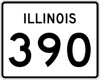
Illinois Route 390 (IL 390), previously known as the Elgin–O'Hare Expressway, now known as the Elgin–O'Hare Tollway, is a 9.8-mile (15.8 km) controlled-access toll road in northeastern Illinois. IL 390 currently connects U.S. Route 20 in Hanover Park to the interchange with Illinois Route 83 and Thorndale Avenue in Wood Dale. The only other towns it borders are Schaumburg and Roselle. Construction is underway to extend the road from IL 83 to the western edge of O'Hare International Airport.
Area code 312 is a telephone area code in the North American Numbering Plan for the city of Chicago, including downtown, the Chicago Loop, and its immediate environs. The numbering plan area is completely surrounded by area code 773, which serves the rest of Chicago. Both area codes form an overlay complex with area code 872. 312 is an enclave area code, and is roughly bounded by North Avenue on the north, Western Avenue on the west, and 35th Street on the south, with Lake Michigan to the east. In terms of geographic area covered, 312 is one of the smallest area codes in the nation, encompassing only a few square miles.
Area codes 630 and 331 are telephone area codes in the North American Numbering Plan (NANP) for portions of Chicago's near and far western suburbs, including the majority of DuPage County, Illinois. To the northwest, the numbering plan area (NPA) also includes a small portion of Cook County, including parts of Schaumburg, Streamwood and Hanover Park. To the west, Kane County is divided between area codes 847 and 224 in the north, including Elgin, and area codes 630 and 331 in the south, including Aurora. To the south, the northern part of Will County and a small part of southern Cook County, including the village of Burr Ridge and parts of the village of Lemont, are also included in the 630 and 331 area codes. To the southwest, the city of Yorkville, in exurban Kendall County, is included, as well.
Illinois is in the midwestern United States. Surrounding states are Wisconsin to the north, Iowa and Missouri to the west, Kentucky to the east and south, and Indiana to the east. Illinois also borders Michigan, but only via a northeastern water boundary in Lake Michigan. Nearly the entire western boundary of Illinois is the Mississippi River, except for a few areas where the river has changed course. Illinois' southeastern and southern boundary is along the Wabash River and the Ohio River, whereas its northern boundary and much of its eastern boundary are straight survey lines. Illinois has a maximum north–south distance of 390 miles (630 km) and 210 miles (340 km) east-west. Its total area is 57,918 square miles (150,010 km2).
The Toledo Metropolitan Area, or Greater Toledo, or Northwest Ohio is a metropolitan area centered on the American city of Toledo, Ohio. As of the 2020 census, the four-county Metropolitan Statistical Area (MSA) had a population of 646,604. It is the sixth-largest metropolitan area in the state of Ohio, behind Cincinnati–Northern Kentucky, Cleveland, Columbus, Dayton, and Akron.
Interstate 94 (I-94) generally runs north–south through the northeastern portion of the US state of Illinois, in Lake and Cook counties. It is signed east–west in Illinois in accordance with its general alignment across the country, with west signage aligned with northbound travel and vice versa. I-94 in Illinois is 61.53 miles (99.02 km) long.
The 11th congressional district of Illinois is represented by Democrat Bill Foster.
Northern Illinois is a region generally covering the northern third of the U.S. state of Illinois. The region is by far the most populous of Illinois, with nearly 9.7 million residents as of 2010.
The U.S. State of Illinois currently has 47 statistical areas that have been delineated by the Office of Management and Budget (OMB). On July 21, 2023, the OMB delineated 14 combined statistical areas, 12 metropolitan statistical areas, and 21 micropolitan statistical areas in Illinois. As of 2023, the largest of these is the Chicago-Naperville, IL-IN-WI CSA, comprising the area around Illinois' largest city, Chicago.
Collar counties is a colloquialism for DuPage, Kane, Lake, McHenry, and Will counties, the five counties of Illinois that border Cook County, which is home to Chicago. The collar counties are part of the Chicago metropolitan area and comprise many of the area's suburbs. While Lake County, Indiana, also borders Cook County, it is not typically included in the phrase "Collar Counties" due to different socioeconomic characteristics and positionality.
The 2020 estimate of the Jewish population in metropolitan Chicago is around 319,600, according to Brandeis University's Chicago Report. The population of Jewish people within the City of Chicago's limits is estimated to be around 240,000, with another 80,000 residing in the suburbs surrounding the major city. At the end of the 20th century there were a total of 270,000 Jews in the Chicago area, with 30% in the city limits. In 1995, over 80% of the suburban Jewish population lived in the northern and northwestern suburbs of Chicago. At this time, West Rogers Park was the largest Jewish community within the city of Chicago. However, the Jewish population within the city had been declining and tended to be older and more well-educated than the Chicago average. The Jewish immigrants to Chicago came from many different countries, with the most common being Eastern Europe and Germany.
↑ Mariner, Richard D. (July 10, 2018). "Collar Counties". The Electrictronic Encyclopedia of Chicago. Chicago, IL: Chicago Historical Society (2005), Newberry Library (2004).
This page is based on this Wikipedia article Text is available under the CC BY-SA 4.0 license; additional terms may apply. Images, videos and audio are available under their respective licenses.