Greater Dhaka

Last updated
Greater Dhaka
Dhaka oli 202279 lrg.jpg
Satellite image of Greater Dhaka metropolitan region
GreaterDhaka.png
Dhaka city is shown in blue and other towns and cities are shown in red
City corporation and Municipalities
Area
  Total1,854 km2 (716 sq mi)
Population
 (2022)
  Total22,478,116
GDP (PPP, constant 2015 values)
  Year2023
  Total$285.1 billion [1]
  Per capita$12,300

Greater Dhaka is the Megalopolis including and surrounding the Bangladeshi capital city of Dhaka, which has grown into one of the world's largest megacities, and shows a very rapid rate of expansion. Dhaka not only grows because it is the capital and largest urban center but also due to massive internal displacement from millions of people living in a perennially flood-prone river delta.

Contents

Definition

The area of Dhaka Statistical Metropolitan Area was 1,353 square kilometers, of which Dhaka City Corporation occupied 276 square kilometers at the 2001 census. [2] The Dhaka Statistical Metropolitan Area (SMA) covers the Dhaka Municipal Corporation area and Savar Upazila and Keraniganj Upazila of Dhaka District (note: only a portion of the district is part of the metropolitan area), Narayanganj Sadar Upazila, Bandar Upazila and Rupganj Upazila of Narayanganj District, Gazipur Sadar Upazila and Kaliakair Upazila of Gazipur District. New 2021 estimates for Bangladesh Bureau of Statistics (web) tally just over 24 million for 4 districts in their entirety. (white area in map also includes 6 districts: Manikganj and Munshiganj)

Components of the Metropolitan Area

Since the 2001 Census, Dhaka has grown tremendously, as evidenced by the 2011 Census figures. However, definitions were changed between the two censuses, with several outlying upazilas situated in neighbouring administrative districts being included in the expanded definition. The following table shows the revision of the metropolitan area, shown in blue and red on map, based on 2011 figures:

Administrative districtIncluded areaArea in km2 (2011) [lower-alpha 1] Population (2001) [3] Population (2011) [3] [4] [5] [6] Population per km2 (2011)
Dhaka District Dhaka City Corporation and Surrounding Thanas (blue on map)3016,881,0258,906,03930,749
Savar Upazila 283629,6951,385,9105,115
Keraniganj Upazila 167649,373794,3604,943
Narayanganj District Narayanganj Sadar Upazila 101946,2051,323,60013,717
Bandar Upazila 54267,021312,8416,015
Rupganj Upazila 176423,135534,8683,163
Gazipur District Gazipur Sadar Upazila 458925,4541,820,3744,151
Kaliakair Upazila 314278,967483,3081,604
Metropolitan Area1,85411,000,87515,561,3008394
  1. Areas may differ from 2001 due to changes in accuracy or natural changes in land boundaries.

Related Research Articles

<span class="mw-page-title-main">Comilla District</span> District of Bangladesh in Chittagong Division

Comilla District, officially known as Cumilla District, is a district located in southeastern Bangladesh. It lies about 100 kilometres south east of Dhaka. Comilla is bordered by Brahmanbaria and Narayanganj districts to the north, Noakhali and Feni districts to the south, Tripura state of India to the east and Munshiganj and Chandpur districts to the west.

<span class="mw-page-title-main">Tangail District</span> District in Dhaka Division, Bangladesh

Tangail is a district (zila) in the central region of Bangladesh. In 1969, Tangail district was created by Tangail Mohokuma from its 237 square kilometers of land and 3177 square kilometers of land acquired from Mymensingh district. It is the largest district of Dhaka division by area and second largest by population. The population of Tangail zila is about 4 million and its area is 3,414.28 square kilometres (1,318.26 sq mi). The main city of the district is Tangail. It is surrounded by Jamalpur District on the north, the Dhaka and Manikganj Districts on the south, the Mymensingh and Gazipur on the east, and the Sirajganj on the west.

<span class="mw-page-title-main">Narayanganj District</span> Place in Dhaka, Bangladesh

Narayanganj District is a district in central Bangladesh which is a part of the Dhaka Division. It is second smallest district in Bangladesh after Jhenaidah .It is home to the ancient city of one of the oldest industrial districts in the country. The district lies on the banks of the Shitalakshya River and the Meghna River. It is an industrial hub and plays an important part in the country's jute trade, plant processing and sector. It is nicknamed the "Dundee of Bangladesh" due to the presence of many jute mills.

<span class="mw-page-title-main">Narsingdi District</span> District of Bangladesh in Dhaka

Narsingdi District is a district in central Bangladesh. It is located 50 km north-east of Dhaka, capital city of Bangladesh. It is a part of the Dhaka Division. The district is famous for its textile craft industry. Narsingdi is bordered by Kishoreganj in the north and north-east, Brahmanbaria in the east and south-east, Narayanganj in the south and south-west and Gazipur in the west.

<span class="mw-page-title-main">Gazipur District</span> District in Dhaka, Bangladesh

Gazipur is a district in central Bangladesh, part of the Dhaka Division. It has an area of 1741.53 km2. It is the home district of Tajuddin Ahmad, the first Prime Minister of Bangladesh and has been a prominent centre of battles and movements throughout history. Gazipur is home to the Bishwa Ijtema, the second-largest annual Muslim gathering in the world with over 5 million attendees. There are many facilities available in this district as it contains numerous universities, colleges, the Bangabandhu Sheikh Mujib Safari Park, Bhawal National Park as well as the country's only business park - the Bangabandhu Hi-Tech City.

<span class="mw-page-title-main">Gazipur</span> Metropolis in Dhaka Division, Bangladesh

Gazipur is a city in central Bangladesh. It is located in the Gazipur District. It is a major industrial city 25 km (16 mi) north of Dhaka. It is a hub for the textile industry in Bangladesh. 75% of all the garments industries are situated here. It is one of the biggest and fastest growing cities in Bangladesh. It is one of the 11 cities of Bangladesh which are administered by a city corporation Among the city corporations it is the youngest, only having been established in 2013, although it is the largest in size. Mirzapur Union is situated at the north of the city, in south Dhaka North City Corporation and Savar Yarpur Union are situated. In the east side there is Baria Union, Kaliganj Upazila, Gazipur and Sreepur Upazila, Gazipur. Mouchak and Maddhapara union of Kaliakair Upazila, and Shimulia and Damshona of Savar are at the west.

<span class="mw-page-title-main">Dohar Upazila</span> Upazila in Dhaka, Bangladesh

Dohar is an upazila of Dhaka District in the division of Dhaka, Bangladesh. The upazila is situated in the southernmost part of Dhaka District. The Padma River borders the southern part of the upazila.

<span class="mw-page-title-main">Keraniganj Upazila</span> Upazila in Dhaka, Bangladesh

Keraniganj is an upazila of Dhaka District in the division of Dhaka, Bangladesh.

<span class="mw-page-title-main">Gazipur Sadar Upazila</span> Upazila in Dhaka, Bangladesh

Gazipur Sadar is an upazila (sub-district) of the Gazipur District in central Bangladesh, part of the Dhaka Division.

<span class="mw-page-title-main">Kaliakair Upazila</span> Upazila in Dhaka, Bangladesh

Kaliakair is an upazila (sub-district) of the Gazipur District in central Bangladesh, part of the Dhaka Division.

<span class="mw-page-title-main">Jamalpur Sadar Upazila</span> Upazila in Mymensingh Division, Bangladesh

Jamalpur Sadar is an upazila of Jamalpur District in the Division of Mymensingh, Bangladesh.

<span class="mw-page-title-main">Munshiganj Sadar Upazila</span> Upazila in Dhaka, Bangladesh

Munshiganj Sadar is an upazila of Munshiganj District in the Division of Dhaka, Bangladesh.

<span class="mw-page-title-main">Sreenagar Upazila</span> Upazila in Dhaka, Bangladesh

Sreenagar is an upazila of Munshiganj District in the Division of Dhaka, Bangladesh. Division of Dhaka

<span class="mw-page-title-main">Bandar Upazila</span> Upazila in Dhaka, Bangladesh

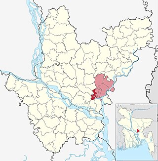
Bandar is an upazila (sub-district) of the Narayanganj District in central Bangladesh, part of the Dhaka Division. Bandar is a part of Greater Dhaka; the conurbation surrounding the Bangladeshi capital city of Dhaka.

<span class="mw-page-title-main">Narayanganj Sadar Upazila</span> Sub-District in Narayanganj district,Dhaka division,Bangladesh

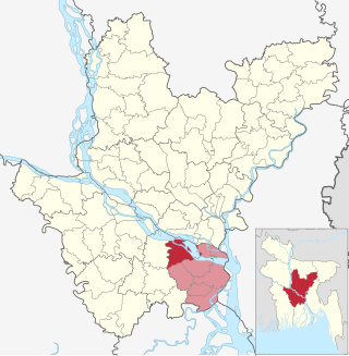
Narayanganj Sadar is an upazila of Narayanganj District in the Division of Dhaka, Bangladesh.

<span class="mw-page-title-main">Baliakandi Upazila</span> Upazila in Dhaka, Bangladesh

Baliakandi is an Upazila of Rajbari District in the Division of Dhaka, Bangladesh.

<span class="mw-page-title-main">Zajira Upazila</span> Upazila in Dhaka, Bangladesh

Zajira is an upazila of Shariatpur District in the Division of Dhaka, Bangladesh. Zajira Thana was established in 1973 and was converted into an upazila in 1984. It was named after its administrative center, the town of Zajira.

<span class="mw-page-title-main">Gazipur-3</span> Constituency of Bangladeshs Jatiya Sangsad

Gazipur-3 is a constituency represented in the Jatiya Sangsad of Bangladesh since 2024 by Rumana Ali of the Awami League.

<span class="mw-page-title-main">Narayanganj-5</span> Constituency of Bangladeshs Jatiya Sangsad

Narayanganj-5 is a constituency represented in the Jatiya Sangsad of Bangladesh since 2014 by Salim Osman of the Jatiya Party (Ershad).

References

  1. "TelluBase—Dhaka Fact Sheet (Tellusant Public Service Series)" (PDF). tellusant.com. Tellusant, Inc. Retrieved 2024-01-11.
  2. "Introduction" (PDF). Dhaka City State of the Environment: 2005. United Nations Environment Programme. 2003. Archived from the original (PDF) on 2014-07-15.
  3. 1 2 Bangladesh Bureau of Statistics - Community Report
  4. "Community Report: Dhaka Zila". Archived from the original on 2012-10-09. Retrieved 2012-10-09.
  5. "Community Report: Gazipur Zila". Archived from the original on 2012-10-07. Retrieved 2012-10-09.
  6. "Community Report: Munshiganj Zila". Archived from the original on 2012-10-08. Retrieved 2012-10-09.