Tongi

Last updated • 3 min readFrom Wikipedia, The Free Encyclopedia
Tongi
টঙ্গী
Tongi Flyover.JPG
A road in Tongi
Bangladesh Dhaka division location map.svg
Red pog.svg
Tongi
Location in Dhaka Division
Bangladesh adm location map.svg
Red pog.svg
Tongi
Location in Bangladesh
Coordinates: 23°54′N90°25′E / 23.90°N 90.41°E / 23.90; 90.41
Country Flag of Bangladesh.svg  Bangladesh
Division Dhaka Division
District Gazipur District
Government
  Type Mayor–Council
  Body Gazipur City Corporation
Area
  Total
32.07 km2 (12.38 sq mi)
Population
 (2011)
  Total
350,000 [1]
  Rank
36th [2]
Time zone UTC+6 (Bangladesh Time)
National Dialing Code +880

Tongi (Bengali : টঙ্গী) is a major township in Gazipur, Bangladesh, with a population of 350,000. It hosts the Biswa Ijtema and features a BSCIC industrial area, which produces BDT 1500 crore of industrial products annually, [3] [4] and marks the northern border of Dhaka since 1786. [5] Tongi Shahid Smrity high School compound is mass burial site of the genocide in Liberation War of Bangladesh. [3]

Contents

History

Ruins of Tungy Bridge, an etching by Charles D'Oyly's (1825). Ruins of Tungy Bridge (1825).jpg
Ruins of Tungy Bridge, an etching by Charles D'Oyly's (1825).

Mir Jumla II (1660–1663) built a fort to protect the northern entry of Dhaka during his reign as a Mughal subadar (1660–1663). [5] [6] The subadar also built a bridge over the river Turag. [5] Mir Jumla constructed a road, now a part of the Dhaka-Mymensingh highway, that connected Tongi with Bag-e-Badshahi . It served as an axis of urban growth in the 19th and 20th centuries as sites for establishment of new urban settlements - Gulshan (formed in 1961), Banani (in 1964), Baridhara (in 1972) and Uttara (in 1965) - were picked off the highlands along that axis road. [5]

In 1786, Tongi-Jamalpur was designated as the northern boundary of Dhaka by the East India Company, reaffirmed by John Taylor, the first English Commercial Resident of Dhaka in 1800. [5]

Geography and administration

Tongi, a thana (police station) within the Gazipur Sadar Upazila along with Joydebpur since 1983, [3] is located immediately north of Dhaka. It lies within the jurisdiction Gazipur District, which is a part of the Dhaka Division.

Geologically, the Tongi area comprises the southern extension of the Madhupur tract, a long narrow tract of tectonically elevated area of older sediments only a few metres above the surrounding rivers the Turag. Locally, the Tract is subdivided into the Bhawal Garh terrace which is a part of an inlier, an elevated area surrounded by lowlands by very young riverine sediments occupying the surrounding valleys. The older sediment sequence consists of sandstone of the Dupi Tila Formation overlain by Madhupur Clay, which in turn is overlain by alluvium. The elevation of the Tract varies from 2 to 14 m above mean sea level and it has shallow bedrock which forms a firm substrate for supporting large structures. [7]

Demography

Many of the people who live in Tongi commute to Dhaka each day, mainly by bus. Many people are also employed at factories in Export Processing Zones, areas given special tax and tariff exemptions by the government in order to stimulate industry. [8]

River

Turag River Fishing in Turag River, Dhaka, Bangladesh.jpg
Turag River

Tongi has a bordering river called the Turag River, it is very actively used by the local commuters and traders. [9] The annual Bishwa Ijtema is also held in Tongi beside the banks of Turag River. [10]

Thana

There are two thanas in Tongi – Tongi East [11] and Tongi West Thana. [12]

Transport

Tongi junction Tongi Railway Station, Bangladesh.JPG
Tongi junction

The newly constructed Tongi Diversion Road forms another important artery of the road network leading to Dhaka. [5]

The Narayanganj–Dhaka–Mymensingh State railway was opened in 1885–86. [5] Tongi has a break of gauge junction station in the same name where the new cross country line across the Jamuna Bridge from the western section joins the eastern section. Tongi is situated on the bank of the river Turag, transport boats and cargo boats are also available here.

Education

Educational institutions in this area include:

Medical colleges and hospitals

Notable People

Related Research Articles

<span class="mw-page-title-main">Jamalpur District</span> District of Bangladesh in Mymensingh

Jamalpur District is a district in Bangladesh, part of the Mymensingh Division. It was established in 1978. It has its headquarters in Jamalpur.

<span class="mw-page-title-main">Netrokona District</span> District of Bangladesh in Mymensingh

Netrokona District is a district of Mymensingh Division in north-east of Bangladesh.

<span class="mw-page-title-main">Gazipur District</span> District of Bangladesh in Dhaka

Gazipur District is a district in central Bangladesh, that is part of the Dhaka Division. It has an area of 1806.36 km2. It is the home district of Tajuddin Ahmad, the first Prime Minister of Bangladesh and has been a prominent centre of battles and movements throughout history. Gazipur is home to the Bishwa Ijtema, the second-largest annual Muslim gathering in the world with over 5 million attendees. The district is home to numerous universities, colleges, the Bangabandhu Sheikh Mujib Safari Park, Bhawal National Park as well as the country's only business park - the Bangabandhu Hi-Tech City.

<span class="mw-page-title-main">Bishwa Ijtema</span> Worldwide Muslim gathering in Bangladesh

The Bishwa Ijtema is an annual gathering of Muslims in Tongi, by the banks of the River Turag, in the outskirts of Dhaka, Bangladesh. The Ijtema is considered a demonstration of Muslim unity, solidarity, mutual love and respect and an opportunity to reiterate their commitment to Islamic values. It is the biggest festival by population in Bengali culture, one of the largest peaceful gatherings in the world, and the second-largest Muslim gathering, with 5 million adherents, after the Arba'een Pilgrimage's 15–20 million attendees in Iraq, both surpassing the 2–3 million worshipers who participate in the Hajj, considered to be one of the five pillars of Islam, in Saudi Arabia. Bishwa Ijtema is a modern event where Muslim participation is voluntary.

<span class="mw-page-title-main">Dhaka District</span> District of Bangladesh in Dhaka

Dhaka District is a district in central Bangladesh, and is the densest district in the nation. It is a part of the Dhaka Division. Dhaka, the capital of Bangladesh, and rests on the eastern banks of the Buriganga River which flows from the Turag to the southern part of the district. The former Dhaka city corporation occupied only about a fifth of the area of Dhaka district until 2011 where the municipal corporation was fractionated and rearranged in North and South corporations due to being the economic, political and cultural centre of the district and also the country. Dhaka District consists of Dhaka city, Keraniganj, Nawabganj, Dohar, Savar and Dhamrai upazila. Dhaka District is an administrative entity, and like many other cities, it does not cover the modern conurbation which is Greater Dhaka, which has spilled into neighbouring districts, nor does the conurbation cover the whole district, as there are rural areas within the district.

<span class="mw-page-title-main">Gazipur Sadar Upazila</span> Upazila in Dhaka, Bangladesh

Gazipur Sadar is an upazila (sub-district) of the Gazipur District in central Bangladesh, part of the Dhaka Division.

<span class="mw-page-title-main">Kaliakair Upazila</span> Upazila in Dhaka, Bangladesh

Kaliakair is an upazila (sub-district) of the Gazipur District in central Bangladesh, part of the Dhaka Division.

<span class="mw-page-title-main">Fulbaria Upazila</span> Upazila in Mymensingh, Bangladesh

Fulbaria is an upazila of the Mymensingh District in Bangladesh.

<span class="mw-page-title-main">Ishwarganj Upazila</span> Upazila in Mymensingh, Bangladesh

Ishwarganj is an administrative area in north-eastern Bangladesh. It is an upazila in Mymensingh District.

<span class="mw-page-title-main">Khaliajuri Upazila</span> Upazila in Mymensingh, Bangladesh

Khaliajuri is an upazila (sub-district) of the Netrokona District in Bangladesh, part of the Mymensingh Division.

<span class="mw-page-title-main">Uttara (neighbourhood)</span> Planned residential neighbourhood in Dhaka, Bangladesh

Uttara Model Town or simply Uttara is a neighbourhood of Dhaka, the capital of Bangladesh. The name derives from the Bengali word uttor meaning "north". It lies on the road to Gazipur, and adjoins Hazrat Shahjalal International Airport.

<span class="mw-page-title-main">Turag River</span> River in Bangladesh

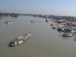
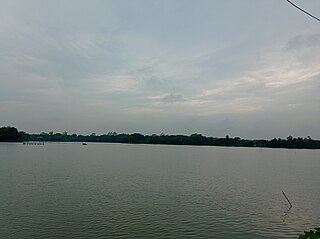
Turag River is the upper tributary of the Buriganga, a major river in Bangladesh. The Turag originates from the Bangshi River, the latter an important tributary of the Dhaleshwari River, flows through Gazipur and joins the Buriganga at Mirpur in Dhaka District. It is navigable by boat all year round.

<span class="mw-page-title-main">Bhawal National Park</span> National park in Bangladesh

Bhawal National Park is a nature reserve and national park of Bangladesh.

<span class="mw-page-title-main">Bangshi River</span> River in Bangladesh

The Bangshi is an important river in central Bangladesh. It originates in Jamalpur, from the course of the old Brahmaputra and flows past the Madhupur tract. It flows through Tangail and meets the Tongi in Ghazipur. It passes near Jatiyo Smriti Soudho in Savar and falls into the Dhaleshwari. About 238 kilometres (148 mi) long, it is not navigable for most of the year except when swelled by the monsoon rains. Louhajang River is a tributary of the Bangshi. Dhamrai on the banks of the Bangshi is famous for its muslin weaving.

The Tongi–Bhairab–Akhaura line is a railway line connecting Tongi and Akhaura, via Bhairab Bazar in Bangladesh. There is a branch line from Bhairab Bazar to Mymensingh via Gouripur. These tracks are under the jurisdiction of Bangladesh Railway.

Uttar Khan is a Thana of Dhaka District in the Division of Dhaka, Bangladesh.

Khilkhet Thana is a thana (sub-district) of Dhaka, Bangladesh. It was created in 2005.

Turag Thana is a thana, an administrative unit, in Dhaka City, Bangladesh. Turag Thana police station is the designated police station of the thana.

<span class="mw-page-title-main">Tongi Junction railway station</span> Railway station in Gazipur, Bangladesh

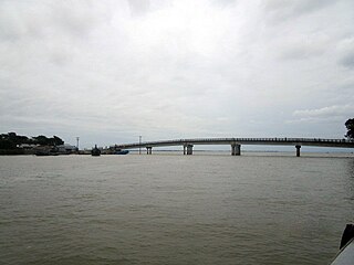
Tongi Junction Railway Station is a railway station in Bangladesh located in Tongi, Gazipur District. It is a station between Dhirashram and Dhaka Airport railway station. It is about 5 km north of the airport station and about 12 km south of Joydebpur. The station is served by two dual gauge lines and two platforms. Tongi–Bhairab–Akhaura line starts from this station. During the Bishwa Ijtema, it become a hub of communication and additional trains plied the station.

<span class="mw-page-title-main">New Dhaka</span> Region in Dhaka District, Bangladesh

New Dhaka, is an unofficial term used to describe the area located north of Old Dhaka that has been incorporated in the city of Dhaka, the capital and largest city of Bangladesh over time. The term is ambiguous, as it may refer either to upscale and/or planned neighbourhoods with wider streets, modern buildings, and improved facilities, or to the city of Dhaka excluding the Old Dhaka region.

References

  1. "Population & Housing Census-2011: Urban Area Report" (PDF). Bangladesh Bureau of Statistics . Retrieved 2019-10-07.
  2. "Population & Housing Census-2011: Urban Area Report" (PDF). Bangladesh Bureau of Statistics. p. 11. Retrieved 2019-10-07.
  3. 1 2 3 Ahmed, Md Farid Uddin (2012). "Gazipur District". In Islam, Sirajul; Jamal, Ahmed A. (eds.). Banglapedia: National Encyclopedia of Bangladesh (Second ed.). Asiatic Society of Bangladesh.
  4. "Tongi Bangladesh Small and Cottage Industries Corporation (BSCIC), produces Tk 1500 cr industrial goods annually". Daily News Monitoring Service. BSS. 2005-01-20. Archived from the original on 2011-07-23. Retrieved 2007-04-24.
  5. 1 2 3 4 5 6 7 Chowdhury, AM (2012). "Dhaka". In Islam, Sirajul; Jamal, Ahmed A. (eds.). Banglapedia: National Encyclopedia of Bangladesh (Second ed.). Asiatic Society of Bangladesh.
  6. Alam, Helemul (2006-03-21). "DCC demolishes Dhaka gate at Banani". New Age. Archived from the original on 2007-09-30. Retrieved 2007-04-23.
  7. Alam, MK; Aurangzeb, MM (1975). "Geological environment for Greater Dhaka City". Proceedings of 3rd Annual Conference. Dhaka: Bangladesh Geological Society. pp. 34–37.
  8. "Bangladesh". Global Connectivity and Exchange Project. Department of State, USA. Retrieved 2007-04-22.
  9. "Turag River". Banglapedia.
  10. "2nd phase of Biswa Ijtema ends with prayer for peace". Dhaka Tribune. 21 January 2018.
  11. "লিখে দেওয়া জমিতে বাড়ি করেছেন ছেলে, সেখানে ঠাঁই হলো না মায়ের". Prothom Alo (in Bengali). 13 March 2022.
  12. "গাজীপুর মেট্রোপলিটন পুলিশে বদলি টঙ্গী পশ্চিম থানায় নতুন ওসির যোগদান". Daily Naya Diganta (in Bengali). 5 December 2020.